Morne Trois Pitons, Dominica
| Topics: |
Geology (main)
|
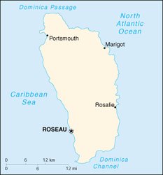
Morne Trois Pitons, named for its highest point, a 1437 meter high volcanic stub, includes extensive undisturbed tropical forest in the Lesser Antilles and the headwaters of most of the major streams and rivers of southern Dominica. Its range of five volcanoes contains a rare combination of precipitous slopes and deeply incised valleys, the richest biodiversity in the Lesser Antilles with freshwater lakes, 50 fumaroles, hot springs, a boiling lake, and spectacular scenery. The site was designated as Morne Trois Pitons National Park in 1975. Morne Trois Pitons (15°16'-15°23'N, 61°17'-61°21'W) is located 13 kilometers (km) east of the town of Roseau in the highlands of south-central Dominica.
Contents
- 1 Date and History of Establishment
- 2 Area
- 3 Land Tenure
- 4 Altitude
- 5 Physical Features
- 6 Climate
- 7 Vegetation
- 8 Fauna
- 9 Cultural Heritage
- 10 Local Human Population
- 11 Visitors and Visitor Facilities
- 12 Scientific Research and Facilities
- 13 Conservation Value
- 14 Conservation Management
- 15 IUCN Management Category
- 16 Further Reading
Date and History of Establishment
- 1952: Morne Trois Pitons was first proposed as a forest reserve
- 1975: The area was designated as National Park under the National Parks and Protected Areas Act No. 16 of July
- 1997: Inscribed on the World Heritage List
Area
6,857 hectares (ha) .
Land Tenure
Morne Trois Pitons National Park was established from former government lands and a private contribution from the former Middleham Estate, which was originally donated to The Nature Conservancy by John Archbold. The Conservancy held the approximately 400 ha of land in trust until 1980, and then transferred ownership to the Commonwealth of Dominica for inclusion in the park. A few small private inholdings remain and certain rights-of-way have been granted to the Dominica's Electric Utility Company (DOMLEC).
Altitude
500 to 1,220 meters (m).
Physical Features
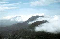
Morne Trois Pitons is the basaltic spike-like remains of a former volcano rising to approximately 1,300 m, within 8 km of the {C}sea. The landscape is characterized by volcanic piles with precipitous slopes, and deeply incised {C}valleys (glacis slopes). There is also a {C}fumarole known as Valley of Desolation (or Grand Soufriere), with fumaroles, {C}hot springs, mud pots, {C}sulfur vents and the Boiling Lake, which is the world's second largest of its kind. The valley is a large amphitheatre surrounded by mountains and consisting of at least three separate craters where {C}{C}steam vents, small {C}{C}ponds, and hot springs bubble up through the ground. Boiling Lake is surrounded by cliffs and is almost always covered by clouds of {C}{C}steam. The lake's {C}water level and colour are highly variable, often bubbling and churning at about 95°C, and making dull roaring sounds. The Valley of Desolation drains into the Pointe Mulatre River, which flows into the {C}Atlantic Ocean.
Other outstanding features in the area include the Emerald Pool, fed by the Middleham Falls; Stinking Hole, a {C}lava tube in the middle of the forest; and the Boeri and Freshwater Lakes. The Freshwater Lake is the largest and second deepest of Dominica's four freshwater lakes. The Boeri Lake is the second largest in Dominica, and is located in the crater of an extinguished volcano. Both lakes are separated from each other by Morne Macaque (1,221 m) and vary in depth with the season. Both are thought to have originated about 25,000-30,000 years ago. The park also encompasses nearly all the headwaters of the streams and rivers in the southern half of the island.
There are three types of soils groups represented within the park, allophanoid clays, kandoid, and protosols. These soils are primarily differentiated by the degree of chemical weathering they have undergone.
Climate
The climate is classified as humid tropical marine (Air masses and frontal transitional zones), with little seasonal or diurnal variation. During most of the year there are gentle trade winds averaging 14.5 km per hour (kph). Average temperature range is about 19-27°C from January to June, and 21°C-28°C during the rest of the year. Relative [[humid]ity] is very high at approximately 95 percent, rarely falling below 85 percent. Nearly all the lower elevation rainfall occurs between June and January. Precipitation is usually short in duration but intense, with an average exceeding 7,600 millimeters (mm) per year.
Vegetation
The following five natural vegetation zones are recognized within the area, plus a small patch of encroaching agricultural land. First, elfin/cloud forest, which occurs at the highest elevations, above 914 m, and is almost constantly covered by mist and subject to high winds, rain, and cold [[temperature]s]. Main vegetation types consist of mosses, ferns, shrubs and stunted trees covered by lichens. The two predominant species are Clusia venosa and Lobelia cirisifolia. Second, montane thicket, which is transitional between elfin and montane [[forest]s], and is dominated by spindly trees, about 12-15 m high with small canopies. The most common tree found on steep slopes is Podocarpus coriaceus, the island's only {C}native {C}conifer. In flatter areas, the main tree is Amanoa caribaea (V). Third, montane rain forest, which grows above 610 m and is frequently in cloud cover or fog. The {C}species composition is similar to that of mature {C}rain forest, yet much reduced in stature. Non-vascular {C}epiphytes cover most montane rain forest {C}plants. Fourth, mature rain forest, which grows below 460 m. This zone contains the most luxuriant growth, and is dominated by Dacryodes excelsa, Sloanea spp., and Licania ternatensis. Fifth, secondary rain forest. Vestigial old {C}stands often remain, surrounded by smaller re-growth. Common species include Cyathea spp., Miconia guianensis, Simarouba amara and Chimarrhis cymosa.
Fauna
A full {C}faunal inventory is yet to be completed. However, previous surveys indicate the occurrence of at least seven {C}species of {C}mammal, 50 {C}birds, 12 reptiles and amphibians and 12 {C}crustaceans.
Apart from {C}introduced opossum Didelphys marsupialis and agouti Dasyprocta agouti, there are no terrestrial mammals in the area. Other introduced mammals include {C}feral cats and pigs and rats.
Birds include imperial amazon Amazona imperialis (VU) and red-necked amazon A. arausiaca (VU). Imperial amazon was formerly common but is now threatened in Dominica. A reduced population of the species existed in the Morne Watt area prior to Hurricane David, but now its existence in the park is uncertain. Red-necked amazon was also a commonly seen species, but now is rarely observed in only a few small areas of the park.
There are no poisonous {C}snakes in Dominica. Boa Boa constrictor nebulosa grows to 3.6 m in length and is common in Morne Trois Pitons. Three species of {C}lizards, including the {C}endemic Anolis oculatus, exist in the park. The {C}island's two native species of tree frogs, including the endemic Eleutherodactylus amplinympha, also occur in the park.
There is also a wide variety of moths, butterflies and other insects.
Cultural Heritage
No information available.
Local Human Population
Being located in the roadless interior of Dominica there are only a few small holder farmers using land near the park boundary. Because the area contains the major source of electric power for the island, and of freshwater for several southern communities, the Commonwealth of Dominica reserved certain water (Water governance) and power rights when the National Parks and Protected Areas Act of 1975 was conceived. Currently, DOMLEC rights-of-way and about 2 ha of private inholdings are clustered near Freshwater Lake, a primary entry to the park. There is also a small quarry towards the northeastern border of the Park.
Visitors and Visitor Facilities
The area receives a number of tourists which increases each year. Visitors can drive into the park at two locations: the village of Laudat on the road from Roseau, and the Emerald Pool site on the cross-island road between Roseau and Castle Bruce. Approximately 10,000-15,000 visitors walk to the Emerald Pool each year, and another 1,500-2,000 take the 6 km hike to the Boiling Lake. A number of ancient trails or footpaths, traverse the park running roughly east-west between mountains or north-south along ridges. Some of these were used in the recent past (before the development of roads to the east, completed in 1960) for access to Roseau, and are use for sightseeing. Others were used for hunting and still are used for access to the Valley of Desolation. Some facilities (picnic shelters, tables, washrooms) have been constructed in the park. In addition, a variety of publications (brochures, booklets, leaflets) pertaining to the park and its main attractions have been produced. The park's education program is facilitated through the Environmental Education Unit of the Forestry and {C}Wildlife Division.
Scientific Research and Facilities
Scientific research in the park includes {C}biological studies ({C}flora and {C}fauna {C}distribution/abundance) in the Freshwater Lake area; assessment of environmental impact of {C}ecotourism and recreation; measures of the flow rate of selected streams in the Freshwater/Boeri Lakes area; analysis of past impact of tropical cyclones; studies of natural {C}regeneration of the flora; assessment of the impact of Hurricane David (1979) on the {C}vegetation; and evaluations of the presence of {C}inert gases released by {C}fumaroles in the Valley of Desolation. A university research and training facility is located adjacent to the park at Springfield.
Conservation Value
Morne Trois Pitons {C}National Park includes within its boundaries the {C}headwaters of most major streams and rivers in the southern half of the {C}island. The area protects large tracts of almost intact tropical forest and associated {C}fauna. In particular, the park appears is important for imperial and red-necked amazons, as well as for other {C}species of {C}conservation concern.
Conservation Management
The agency responsible for the management of Morne Trois Pitons National Park is the Forestry and {C}Wildlife Division of the Ministry of Agriculture and the Environment of Dominica. {C}Nongovernmental organizations with important supporting roles include the Dominica {C}Conservation Association (DCA) and Dominica's Electric Utility Company (DOMLEC). In 1975, the first preliminary plan outlining management guidelines for the park was prepared. In 1989, a ten-year management plan for the park was written. Guidelines for the management of the park are also included in the plan prepared by Scheele on behalf of the Organization of American States (1991).
Management Constraints
In 1990, Morne Trois Pitons National Park was classified as being in peril by The Nature Conservancy. A major threat to the area is the foreseeable continuation of hydroelectric and thermal energy development. Recent construction of a hydroelectric project in the park, which occurred without adequate impact assessment and mitigation design, resulted in temporarily increased soil erosion around Freshwater Lake and along the pipeline, deterioration of an access road, stream sedimentation, and possibly a major landslide. Pipeline rights-of-way for one hydroelectric project have been transferred to DOMLEC, complicating decision making in the park. Increased tourism, the need for increasing monitoring and other programs are placing pressure on the limited staff and financial resources of the Forestry and Wildlife Division. It is not known to what extent introduced mammal species may be disturbing the native fauna and flora.
Staff
A total staff of three full time people, including a deputy director and two forest officers. Field supervision is part of the duties of local forest rangers. Some 20 casual laborers also work on trail and facility maintenance.
Budget
An operational budget is provided but capital improvement projects have only been carried out with donor assistance.
IUCN Management Category
- Morne Trois Pitons National Park II (National Park)
- Natural World Heritage Site - Criteria i, iv
Further Reading
- Honychurch, P. N. (1978). Brochures on different facets of the park (Concept and Purpose, Geology and Soils, Wildlife, Vegetation and Water). Dominica National Park Service.
- Lang, D. M. (1967). Soils and land use surveys, No. 21. Dominica. University of the West Indies, Trinidad.
- MacKenzie, T. A. (1984). Preparation of Actual Land Use Map of Dominica. OAS, Washington, DC.
- Organization of American States (1991). Dominica - Morne Trois Pitons National Park Management Plan 1990-2000. Department of Regional Development and Environment, OAS, Washington, DC.
- The Commonwealth of Dominica (1996). World Heritage Nomination of Morne Trois Pitons National Park. 45 pp. + annexes.
- The Nature Conservancy (1995). Parks in Peril Source Book. The Nature Conservancy, Latin America and Caribbean Division. Arlington, Virginia, USA. ISBN: 1886765014 .
- Thorsell, J. W. and Wood, G. (1976). Dominica's Morne Trois Pitons National Park. Nature Canada 5.
- Webber, B. E. (1973). National park creation in a developing nation: A case study of Dominica, West Indies. Ph.D. Thesis, Colorado State University.
| Disclaimer: This article contains information that was originally published by the United Nations Environment Programme- World Conservation Monitoring Centre (UNEP-WCMC). Topic editors and authors for the Encyclopedia of Earth have edited its content and added new information. The use of information from the United Nations Environment Programme- World Conservation Monitoring Centre (UNEP-WCMC) should not be construed as support for or endorsement by that organization for any new information added by EoE personnel, or for any editing of the original content. |