Middle Rocky Mountain Steppe - Coniferous Forest - Alpine Meadow Province
Contents
Middle Rocky Mountain Steppe - Coniferous Forest - Alpine Meadow Province (Bailey)
Blue Mountains, Salmon River Mountains, basins and ranges of southwestern Montana, 81,800 mi2 (211,900 km2)
Land-surface form
Most of central Idaho and the Salmon River Mountains are formed by granitic intrusions that collectively make up the Idaho Batholith, with altitudes ranging from 3,000 to 7,000 ft (900 to 2,130 m). The batholith is deeply dissected, with a relief greater than 3,000 ft, and its granite is heavily weathered over large areas. East of the batholith is a basin-and-range area consisting of mountains, alluvial fans at their bases, and floodplains along the streams draining the valleys. To the west lie the Blue Mountains, which seldom exceed 8,000 ft (2,400 m) but have at least one peak 10,000 ft (3,050 m) high. The Snake River crosses the province at the bottom of Hells Canyon, which is deeper than the Grand Canyon. Many of the region's higher reaches have been glaciated.
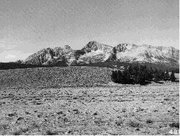 Altitudinal zonation in the Sawtooth Mountains of Idaho, with semidesert shrubs in the foreground, coniferous forests on the lower mountain slopes, and alpine tundra toward the top.
 Climate
Despite the northerly latitudes and high altitudes of this region, its climates are surprisingly mild due to their proximity to the Pacific Ocean. Mean monthly temperatures at Canyon City, Oregon (near John Day), range from just above freezing to 68F (20C). In the mountain valleys of Montana, January temperatures average as much as 10°F (6°C) higher and summer temperatures 5 to 10°F (3 to 6°C) lower than on the Great Plains just to the east. The average length of the growing season is about the same as on the Great Plains, roughly 120 days. Temperature and snowfall, of course, vary greatly with altitude. Winds are from the west, with much of their moisture precipitated where they cross the Pacific ranges. Consequently, most of this portion of the Rocky Mountains is semiarid. Valleys get less than 20 in (510 mm) of precipitation each year; up to 30 in (770 mm) falls in the mountains, mostly as snow.
Vegetation
Altitudinal zones are evident. Below the subalpine zone, Douglas-fir is the climax dominant, with grand fir as an associate west of the continental divide, chiefly on westfacing slopes. Lodgepole pines and grasses grow principally in the basins and ranges in the eastern and southeastern part of the province. Below the Douglas-fir belt, ponderosa pine is dominant to the west of the continental divide, constituting a xerophytic forest. The lower slopes of the mountains and the basal plain are dominated by sagebrush semidesert or steppe.
Due to aridity, forests directly east of the Bitterroot Mountains are usually restricted to northern and eastern slopes. Although south- and westfacing slopes receive comparable precipitation, they are hotter and evaporation is higher. Consequently, they support few trees and are covered by shrubs and grasses.
Soils
Soils of the fans and valley floors, most of which lie below 2,000 ft (600 m), are Mollisols. These soils support sagebrush and grass. Above 2,000 ft, under coniferous forest, the soils are Alfisols. Areas recently glaciated or with steep slopes have Inceptisols.
Fauna
Fauna in the Middle Rocky Mountain Province are like those elsewhere in the Rockies to the north and south. However, parts of the province are filled with mountain ranges that are isolated by stretches of arid territory. Each such range usually contains a group of species peculiar to the region, and some of these species may be found only in a single range.
Return to Ecoregions of the United States
| Disclaimer: This article is taken wholly from, or contains information that was originally published by, the United States Forest Service. Topic editors and authors for the Encyclopedia of Earth may have edited its content or added new information. The use of information from the United States Forest Service should not be construed as support for or endorsement by that organization for any new information added by EoE personnel, or for any editing of the original content. |