MacQuarie Island, Australia
| Topics: |
Contents
- 1 Geographical Location
- 2 Date and History of Establishment
- 3 Area
- 4 Land Tenure
- 5 Altitude
- 6 Physical Features
- 7 Climate
- 8 Vegetation
- 9 Fauna
- 10 Cultural Heritage
- 11 Local Human Population
- 12 Visitors and Visitor Facilities
- 13 Scientific Research and Facilities
- 14 Conservation Value
- 15 Conservation Management
- 16 IUCN Management Category
- 17 Further Reading
Geographical Location
MacQuarie Island (54°29'-54°47'S, 158°47'-158°58'E) is a World Heritage Site located in the Southern Ocean, about half way between New Zealand and the Antarctic continent, approximately 1,500 kilometers (km) south-south-east of Tasmania. Comprises all those areas of Crown land being the islands known as Macquarie Island, Bishop and Clerk Islets, 37 km to the south, Judge and Clerk Islets, 11 km to the north, and including all offshore islands, rocks and reefs extending in each case to the low water mark. The island is part of the State of Tasmania, administratively within the local government area of Esperance. The only access is by sea. The property nominated for inclusion on the World Heritage List comprises that described above, in addition to the surrounding waters to a distance of 12 nautical miles (approximately 22 km).
Date and History of Establishment
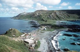 MacQuarie Island, Australia. (Source: Australian Government: Geoscience Australia)
 The island was declared a nature sanctuary in 1933 under the provisions of the Animals and Birds Protection Act, 1928. It was declared a conservation area when the Tasmanian National Parks and Wildlife Act 1970 came into force, and was subsequently made a state reserve under the same act on 14 June 1972. Then, it was approved as a biosphere reserve in 1977 under the UNESCO Man and the Biosphere Programme, and was also put on the Register of the National Estate in the same year. The reserve was extended to its present boundaries and formally named as a nature reserve in 1978. The island was declared a restricted area in 1978 and inscribed on the World Heritage List in 1997.
Area
12,785 hectares (ha).
Land Tenure
The State of Tasmania is the owner of MacQuarie Island, Bishop and Clerk islets, Judge and Clerk islets, adjacent seastacks and reefs and the surrounding water to 3 nautical miles. The Commonwealth of Australia has jurisdiction over the marine area from the limit of Tasmania's territorial waters to 12 nautical miles.
Altitude
0-433 meters (m).
Physical Features
The reserve, an island 34 km long and up to 5 km wide, is the exposed crest of the Macquarie Ridge Complex. This is a component of the oceanic crust, formed in deep water at a spreading ridge and raised to its present position as the Indian-Australian tectonic plate interacts with the Pacific plate. It is perhaps the best preserved section on the globe of oceanic crust formed in deep water and now exposed above sea level. Volcanic rocks, mainly pillow lavas with varying proportions of rare massive lava flows, basaltic dykes and various sediments comprise about 80% of the island. A study of coccoliths in the nanno/foram ooze, characteristic of ocean floor deposition at depths of between 2,000 m and 4,000 m, indicates that the crust was formed during the early or middle Miocene. The northern part of the island mainly comprises intrusive rocks apparently derived from deeper crustal levels than the southern section. Dolerite dyke swarms are extensive in the northern region and also around Lusitania Bay and Sandell Bay in the south. Besides the dyke swarms, the northern section is composed mainly of serpentinised peridotite and gabbro masses, although there are small areas of extrusive volcanic rocks.
The main landscape feature is a central rolling plateau 250m-300 m above sea level, bounded on all sides by steep cliffs, from the foot of which extends a coastal platform up to 800 m wide. Glacial drift up to 20 m thick covers much of the plateau and there are several lakes with a combined area of more than 200 ha. Numerous smaller lakes, tarns and pools are found both on the plateau and on the raised beach terraces. Soils are gravelly loams and peat. The coastline is generally rocky with a number of offshore islands and stacks.
Climate
Meteorological observations have been carried out at the ANARE (Australian National Antarctic Research Expedition) station on the Isthmus during 1911-1913, 1913-1915 and from 1948 to the present.
The island has a cold temperate oceanic climate. Mean seasonal temperature, measured at sea level, varies from 6.6°C in summer to 3.3°C in winter. Mean annual precipitation is 901 millimeters (mm), falling over an average of 308 days per annum. Some 70% of winds are westerly, cloud cover averages seven-eighths in all months, and mean daily sunshine ranges from 0.6 hours in June to 3.5 hours in February.
Vegetation
The vascular flora comprises at least 46 species, in addition to 80 moss species and at least 50 hepatic species. Lichens number some 141 species, and there are at least 90 diatoms and 20 other species of freshwater (Freshwater biomes) algae. The number of marine algae known around the reserve is over 100, Antarctic kelp (Durvillaea antarctica) being dominant. Over 135 mushrooms, 60 cup fungi, 22 slime moulds and 1 false slime mould were recently identified.
Since their introduction to the island, rabbits have modified vegetation alliances in most areas. The rabbit control program, which commenced in 1978, has led to rapid changes in the growth and to a lesser extent the distribution of many vascular species in the reserve.
Four main vegetation formations are recognized: tall tussock grassland, short tussock grassland, mire and feldmark. Tall tussock grassland provides the tallest vegetation cover on the island, there being no trees or tall shrubs. It is dominated by Poa foliosa, either in pure stands or allied with P. cookii and/or Stilbocarpa polaris. Herbfield and short grassland cover areas of the raised beach terraces and the plateau. They also occur on extensive areas of coastal slopes which may previously have been covered by tall tussock grassland associations. Mire occurs on areas of the raised beach terraces, valley bottoms and some poorly drained areas on the plateau and rush Juncus scheuchzerioides is dominant in many areas. Feldmark is the most widespread formation, covering approximately half of the island and occupying the most wind-exposed areas of the plateau region and mountain tops. The cushion-forming Azorella macquariensis is the dominant vascular species in the more sheltered parts of the feldmark.
Fauna
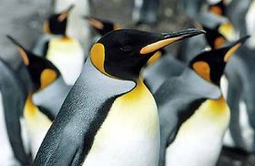 The king penguin Aptenodytes patagonicus has recovered dramatically from the slaughter of the last century, and there population is noted to still be expanding. (Source: Australian Antarctic Division)
 The indigenous fur seal, species unknown, was virtually exterminated within ten years of the island being discovered. The remaining indigenous mammals are all marine, comprising whales and seals, and include Southern right whale (Balaena glacialis), rare sightings of sperm whale (Physeter macrocephalus), orca (Orcinus orca), the most common whale observed at Macquarie Island, and long fin pilot whale (Globicephala melaena), the only other whale to be seen in any numbers around Macquarie Island. The only other positive whale records are southern bottlenose whale (Hyperoodon planifrons) and Cuviers beaked whale (Ziphius cavirostris).
Southern elephant seal (Mirounga leonina) numbered 110,000 during the mid-1950s. New Zealand fur seal (Arctocephalus forsteri), sub-Antarctic fur seal (A. tropicalis) and Antarctic fur seal (A. gazella) are found. Hookers sea lion (Phocarctos hookeri) and leopard seal (Hydrurga leptonyx) visit each winter and spring. Weddell seal (Leptonychotes weddelli) and crabeater seal (Lobodon carcinophagus) are very rare vagrants from the south.
Four species of introduced mammal still survive. In 1978 the over wintering population of European rabbit (Oryctolagus cuniculus) was estimated at 150,000, but in December 1978 control measures were begun using myxomatosis, with an initial overall reduction of more than 50% and in some areas a reduction of over 90%. In 1993 the rabbit population was estimated at less than 10,000. Feral cat (Felis catus) numbers 170-250; their disastrous effects on some of the smaller indigenous birds have been well documented by Jones (1977) and Brothers (1985). House mouse (Mus musculus) and ship rat (Rattus rattus) both became established on the island in the last century.
Seventy-two species of birds have been recorded at Macquarie Island, comprising two endemic sub-species which became extinct in the 19th century (banded rail Rallus phillippensis macquariensis and red-fronted parakeet Cyanoramphus novaezelandiae erythrolis), 25 breeding species, four probably breeding, 38 non-breeding species and three species of domestic poultry which are no longer on the island). The breeding bird fauna includes four penguin species, four albatrosses, fourteen petrels, two ducks, two passerine, one species each of rail, skua, gull, tern, and an endemic sub-species of king cormorant (Phalacrocorax albiventer purpurascens), estimated at 660 pairs.
Penguins are the most numerous birds breeding on the island at the present day. King penguin (Aptenodytes patagonicus) has recovered dramatically from the slaughter of the last century and the population, estimated at 400,000 in 1989, is still expanding; gentoo penguin Pygoscelis papua papua population in the area is about 5,000 breeding pairs; royal penguin (Eudyptes schelegli) is endemic to the MacQuarie Island, with a breeding population of 850,000 in 57 colonies; and rockhopper penguin (E. chrysocome) breed in medium to large colonies with a total population of 500,000 breeding pairs.
Wandering albatross (Diomedea exulans), black-browed albatross (D. melanophrys) and grey-headed albatross (D. chrysostoma) occur in lower numbers than the 1,500-2,000 pairs of light-mantled sooty albatross Phoebetria palpebrata. No native passerine have been recorded, but redpoll (Acanthis flammea) and common starling (Sturnus vulgaris) are both widespread and common. Weka Gallirallus australis scotti were introduced from New Zealand in the mid 1800s as a source of food for the sealers. They probably contributed significantly to the extinction of the endemic sub-species of land rails and parakeets.
The number of fish recorded around the island is 12 benthic and 21 pelagic species. Some 27 species of marine mollusc (64%) are endemic.
It has been estimated that the MacQuarie Island fauna has probably less than 300 species of terrestrial invertebrates. Approximately 10 percent are endemic with a few others doubtfully so.
An annotated checklist of mammals, birds and fish is given in DPWH (1991), and of mammals and birds is given in Commonwealth of Australia (1996).
Cultural Heritage
Sealers discovered the island in 1810 and inhabited it periodically throughout the 19th century, exterminating the fur seals and greatly reducing the elephant seal population. In 1870, gangs came to exploit the king and royal penguins [[population]s] also for oil, eliminating the former. The original elephant seal population of about 93,000 to 110,000 animals was reduced by 70 percent as a result of these operations. The visitors also brought exotic (Exotic species) mammals and caused the extermination of two endemic subspecies of land birds.
Local Human Population
In recent years the ANARE station on the Isthmus has been staffed by 13-21 overwintering personnel, but over the summer periods the number can double. Temporary influxes of over 100 people may occur when resupply or tourist ships visit the island.
Visitors and Visitor Facilities
There is provision within the management plan for tourism, and guidelines for tourism operations are given based on the Tasmanian National Parks and Wildlife Reserves Regulations, 1971. Visitors must be ship-based and facilities such as walkways and viewing platforms may be provided to protect the reserve. A maximum figure of 500 tourists per year has been set by the Parks and Wildlife Service of Tasmania. In fact, since this limit was introduced in 1990-1991, it has only been reached on one occasion.
Scientific Research and Facilities
An active program is conducted under the auspices of ANARE, by an overwintering staff with visiting university and government scientists. A meteorological station was established in 1948 and is still maintained. The station comprises over 40 buildings and structures and smaller structures housing scientific equipment and experiments. Research is wide-ranging and recently has focused on seabird and mammal ecology, causes of erosion and the effects of introduced animals and their control. The Department of Parks, Wildlife and Heritage carries out long-term monitoring (Environmental monitoring and assessment) programs covering changes in the distribution and abundance of individual species and also association composition. A comprehensive bibliography is provided in DASETT (1991).
Proposals to carry out scientific research programs in the reserve are considered by several committees, including Macquarie Island Advisory Committee (MIAC) which liaises between the Department of Parks, Wildlife and Heritage, the Antarctic Division of the Federal Department of the Arts, Sport, the Environment, Tourism and Territories, and other organizations.
Conservation Value
The major purpose of the reservation as a state reserve was the conservation, including the preservation and protection of its flora, fauna natural beauty and cultural resources. The reserve appears to be the best preserved fragment of ocean crust known above sea level.
Conservation Management
A management plan, prepared in accordance with the requirements of the Tasmanian National Parks and Wildlife Act, 1970, took effect on 26 June 1991. This aims to provide maximum protection for the natural and historical assets of the reserve, to repair past damage as far as is desirable and practical, and to encourage research and data-collecting programs on the natural and historical features of the region, providing that they have no long-term detrimental effects. Tourism is catered for within the management plan, but limited to the carrying capacity of the island and its wildlife.
Three zones have been established: one covering the ANARE station; a second covering the whole of the rest of the island, where limited activities may occur; and a third covering the outlying islands which are to be preserved in as near a pristine state as is possible.
Daily administration in the reserve is carried out by the ANARE station leader who is employed by the Antarctic Division and made an honourary ranger under the National Parks and Wildlife Act (1970) for the duration of their stay in the reserve. Legislation relevant to the Island totals 18 Australian Government acts and seven Tasmanian State Government acts, listed in DASETT (1991).
Management Constraints
Rabbits have been the main threat in the past, causing widespread vegetation changes and providing an abundance of prey for cats and the main native predator, brown skua Catharacta lonnbergi, which is now declining as a result of rabbit control. Alien vertebrates are the main threat to native species and the relationships between the two faunas are complex and difficult to assess.
Although Macquarie Island has been severely affected by alien species, management activities are successfully reversing the problem. Programs to eradicate introduced species are being undertaken and considerable success has already been observed. It is possible that wekas no longer exist on Macquarie Island, and cat numbers are now very low, probably fewer than 100 individuals. Parts of the nominated area appear to have remained in pristine condition, including Bishop and Clerk Islets, Judge and Clerk islets and the surrounding marine area.
Increased human activity on the island, through the maintenance of the ANARE station and through tourist visits, has brought with it inevitable, although limited, environmental impacts through, for instance, logistical operations, waste disposal, walking tracks and field huts. It also holds the potential threat of introduction of serious pest species. The Tasmanian Department of Parks, Wildlife and Heritage and the Antarctic Division have established management procedures to deal with these concerns and these are formalized in DPWH (1991).
Staff
The Tasmanian Parks and Wildlife Service usually has between one and three authorized officers working in the area throughout the year. These may be rangers, technical officers, scientific officers or wildlife management officers carrying out research and management programs. Maintenance, communication and other back-up staff are provided by the Antarctic Division.
Budget
Estimated in A$4.7 million for the period between 1 July 1995 to 30 June 1996.
IUCN Management Category
- MacQuarie Island Nature Reserve Ia (Strict Nature Reserve)
- Natural World Heritage Site - Criteria i, iii
Further Reading
- Brothers, N.P. (1985). Breeding biology, diet and morphometrics of the King shag, Phalacrocorax albiventer purpurascens, at Macquarie Island. Australian Wildlife Research 12: 81-94. (Unseen)
- Brothers, N.P. and Skira, I.J. (1984). The weka on Macquarie Island. Notornis 31: 145-154.
- Carrick, R. (1956). The Wildlife of Macquarie Island. Australian Museum Magazine 12(8): 255-260.
- Carrick, R. and Ingham, S.Q. (1962). Studies on the Southern elephant seal, Mirounga leonina (L.). V. population dynamics and utilisation. CSIRO Wildlife Research 7: 198-206. (Unseen)
- Christodoulou, C., Griffin, B.J. and Foden, J. (1984). The geology of Macquarie Island. ANARE Research Notes 21. (Unseen)
- Commonwealth of Australia (1996). MacQuarie Island. Nomination by the Government of Australia for inscription on the World Heritage List. 96 pp. + Annexes. A comprehensive bibliography
- Copson, G.R. (1984). An annotated atlas of the vascular flora of Macquarie Island. ANARE Research Notes 18. 70 pp.
- Copson, G.R. (1988). The status of the black-browed and grey-headed albatrosses on Macquarie Island. Paper Proceedings Royal Society of Tasmania 122(1): 137-141. (Unseen)
- Copson, G.R. and Rounsevell, D.E. (1987). The abundance of royal penguins (Eudyptes schlegii, Finsch) breeding at Macquarie Island. ANARE Research Notes 41. (Unseen)
- Cumpston, J.S. (1968). Macquarie Island. ANARE Scientific Reports Series A(1) No. 93. 330 pp.
- DASETT (1991). Nomination of Macquarie Island by the Government of Australia for inscription on the World Heritage List. Prepared by the Department of the Arts, Sport, the Environment, Tourism and Territories. Canberra, ACT. 79 pp.
- Dell, R.K. (1964). Macquarie and Heard Islands' mollusca. Rec. Dominion Museum 4: 267-301. (Unseen)
- DPWH (1991). Macquarie Island Nature Reserve Management Plan 1991. Department of Parks, Wildlife and Heritage, Tasmania. 57 pp.
- Gillham, M.E. (1967). Subantarctic sanctuary. Reed, Sydney.
- Griffin, B.J. (1982). Igneous and metamorphic petrology of lavas and dykes of the Macquarie Island ophiolite complex. Ph.D. thesis. University of Tasmania. (Unseen)
- Griffin, B.J. and Varne, R. (1980). The Macquarie Island ophiolite complex: mid-tertiary oceanic lithosphere from a major ocean basin. Chemical Geology 30: 285-308. (Unseen)
- Holdgate, M.W. and Wace, N.M. (1961). The influence of man on the floras and faunas of southern islands. Polar Record 10(68): 473-493.
- Jones, E. (1977). Ecology of the feral cat, Felis catus (L.), (Carnivora: Felidae), on Macquarie Island. Australian Wildlife Research 4: 249-262. (Unseen)
- Jones, E. (1980). A survey of burrow-nesting petrels at Macquarie Island based upon remains left by predators. Notornis 27(1): 11-20.
- Jones, E. and Skira, I.J. (1979). Breeding distribution of the great skua at Macquarie Island in relation to numbers of rabbits. Emu 79(1): 19-23.
- Kerry, K.R. and Colback, G.C. (1972). Following the band! Light-mantled sooty albatrosses on Macquarie Island. Australian Bird Bander 10: 61-62. (Unseen)
- King, J.E. (1964). Seals of the world. British Museum (Natural History), London. ISBN: 0801499534.
- Law, P.G. and Bunstall, T. (1953). Macquarie Island. ANARE Interim Reports No. 14.
- Lowry, J.K. and Horning, D.S., Poore, G.C.B., and Ricker, R.W. (1978). The Australian Museum Macquarie Island expedition, summer 1977-78. The Australian Museum Trust November. (Unseen)
- Parks and Wildlife Service of Tasmania (1994). Rabbits and vegetation - their future on MacQuarie Island. 12 pages.
- Quilty, P.G.J., Rubenach, M. and Wilcoxon, J.A. (1973). Miocene ooze from Macquarie Island. Search 4: 163-164. (Unseen)
- Ricker, R.W. (1981). Macquarie Island: a blend of cold temperate, subantarctic and Antarctic seaweeds. Eighth International Biological Congress Abstracts: 186. (Unseen)
- Robertson, G.R. (1986). Population size and breeding success of the gentoo penguin Pygoscelis papua at Macquarie Island. Australian Wildlife Research 13(4): 583-587. (Unseen)
- Rounsevell, D.E. (1984). Summary of biological research on Macquarie Island 1971-82. Tasmanian Naturalist 78: 6-7.
- Rounsevell, D.E. and Brothers, N.P. (1984). The status and conservation of seabirds at Macquarie Island. In: Croxhall, J.P., Evans, P.G.H. and Schreiber, R.W. (Eds.), Status and conservation of the world's seabirds. ICBP Technical Publication No. 2. ICBP, Cambridge, UK. Pp. 587-592. ISBN: 0946888035.
- Rounsevell, D.E. and Copson, G.R. (1982). Growth rate and recovery of a king penguin, Aptenodytes patagonicus, population after exploitation. Australian Wildlife Research 9: 519-525. (Unseen)
- Selkirk, P.M., Seppelt, R.D. and Selkirk, D.R. (1990). Subantarctic Macquarie Island: environment and biology. Cambridge University Press. 285 pp. ISBN: 052107603X.
- Seppelt, R.D., Copson, G.R. and Brown, M.J. (1984). Vascular flora and vegetation of Macquarie Island. Tasmanian Naturalist 78: 7-12.
- Taylor, B.W. (1955). The flora, vegetation and soils of Macquarie Island. ANARE Reports Series B, vol. II, Publication No. 19.
- Taylor, R.H. (1979). How the Macquarie Island parakeet became extinct. N.Z. Journal of Ecology 2: 42-45. (Unseen)
- Tomkins, R.J. (1985). Reproduction and mortality of wandering albatrosses on Macquarie Island. Emu 85(1): 40-42. (Unseen)
- Varne, R. and Rubenach, M.J. (1972). Geology of Macquarie Island and its relationship to oceanic crust. American Geophysics Union Antarctic Research Series 19: 251. (Unseen)
- Varne, R. and Rubenach, M.J. (1973). Geology of Macquarie Island in relation to tectonic environment. In: Coleman, P.J. (Ed.), The western pacific island: island areas, marginal seas, geochemistry. University of W.A. Press. (Unseen)
- Varne, R., Gee, R.D. and Quilty, P.G.J. (1969). Macquarie Island and the cause of oceanic linear magnetic anomalies. Science 166: 230-233. (Unseen)
- Warham, J. (1967). The white-headed petrel Pterodroma lessonii at Macquarie Island. Emu 67: 1-22.
- Watson, G.E. (1975). Birds of the Antarctic and Subantarctic. AGU, Washington. ISBN: 0875901247.
- Williams, R. (1988). The nearshore fishes of Macquarie Island. Paper Proceedings Royal Society of Tasmania. 122(1): 233-245. (Unseen)
| Disclaimer: This article is taken wholly from, or contains information that was originally published by, the United Nations Environment Programme-World Conservation Monitoring Centre (UNEP-WCMC). Topic editors and authors for the Encyclopedia of Earth may have edited its content or added new information. The use of information from the United Nations Environment Programme-World Conservation Monitoring Centre (UNEP-WCMC) should not be construed as support for or endorsement by that organization for any new information added by EoE personnel, or for any editing of the original content. |