Los Katíos National Park, Colombia
Contents
- 1 Introduction
- 2 Geographical Location
- 3 Date and History of Establishment
- 4 Area
- 5 Land Tenure
- 6 Altitude
- 7 Physical Features
- 8 Climate
- 9 Vegetation
- 10 Fauna
- 11 Cultural Heritage
- 12 Local Human Population
- 13 Visitors and Visitor Facilities
- 14 Scientific Research and Facilities
- 15 Conservation Value
- 16 Conservation Management
- 17 IUCN Management Category
- 18 Further Reading
Introduction
Los Katios National Park (7°49'N, 77°12'W) is a World Heritage Site located in Colombia (Los Katíos National Park, Colombia) that shares a border with the Darién National Park in Panama. It is noted for it's diverse habitats and presence of flora and fauna specific to the Central and Southern American regions.
Geographical Location
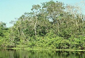 Los Katios National Park, Colombia. (Source: Columbian Ministry of Culture)
 Los Katíos is located in north-west Colombia in the north of the Department of Chocó between the frontier with Panama and the west bank of the river Atrato. It also includes the swamps of Tumaradó to the east of this river and land between the Cacarica, Perancho and Peye rivers. Los Katíos forms a transfrontier protected area with Panama's Darién National Park and World Heritage Site. 7°49'N - 77°12'W
Date and History of Establishment
- 1974: Executive Decree No. 172 created Los Katíos
- 1974: Decree 2811 regulates national parks
- 1977: Reglamentary Decree 622 regulates national parks
- 1980: Executive Decree No. 91extended size from 52,000 hectares (ha) to present size of 72,000 ha
- 1994: Inscribed on the World Heritage List in 1994
Area
72,000 ha, contiguous to Darién National Park (597,000 ha), Panama.
Land Tenure
All land is owned by the government.
Altitude
50 meters (m) to 600 m.
Physical Features
The park extends along the foothills of the Serranía del Darién and the topography is gently undulating. The park comprises two main regions: the mountains of the Serranía del Darién in the west accounting for 53% of the park, and in the east the floodplain of the Atrato river making up 47%. The area is composed of alluvial plain]]with regularly flooded terraces, alluvial plains with rarely flooded high terraces, low hills up to 250 m high, hills up to 60 0m high and marshes. The Atrato river is the fastest flowing river in the world, emptying 4,900 cubic meters of water into the Caribbean every second.
Climate
The park receives a high rainfall of 2,000-4,500 millimeters (mm) per year. Average temperature is 27°C and relative humidity is between 75% and 95%. The months of December to March are slightly drier.
Vegetation
Lowland swamp forests cover approximately half of the park whilst the remainder is lowland through to montane tropical rainforest. The wetlands of the Atrato floodplain are of special interest, and Polygonum acuminatum, Montrichardia arborescens,Raphia taedigera and cativo Prioria copaifera are typical species. Cativo can reach 50 m and gives its name to a formation called 'catival' which is only found in Colombia, south Central America and Jamaica. The tropical rainforests are characterized by Ceiba petandra, Cavanillesia platanifolia (IK), Hura crepitans, caracolí Anacardium excelsum, guaco Brosimum utile, and palma mil pesos Jessenia polycarps (IK). A total of 669 plant species had been recorded by 1993, 20-25% of which are endemic.
Fauna
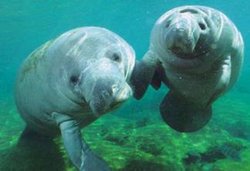 Trichechus manatus. (Source: Duke University)
 Los Katíos supports a number of species which are characteristic of Central America and are only found in this part of South America such as the mouse Heteromys desmarestianus and grey-headed chachalaca Ortalis cinereiceps. The Serranía del Darién is home to many endemic species such as the rufous-cheeked hummingbird Geothalsia bella and violet-capped hummingbird Goldmania violiceps and the frog Rhamphophyrne acrolopha. More than 450 species of bird (representing respectively 25% and 50% of the avifauna of Colombia and Panama) have been recorded within the park. Some 550 species of vertebrate (excluding fish) have been found in the park. The manatee Trichechus manatus (V) has recently been found in the Ciénaga de Tumuradó and the American crocodile Crocodylus acutus (V) occurs in the Ciénaga de Cacarica. Other threatened mammals include bush dog Speothos venaticus (V), giant anteater Myrmecophaga tridactyla (V) and Central American tapir Tapirus bairdii (V).
Cultural Heritage
The region was previously inhabited by the Cunas, an indigenous group which was forced to migrate to Panama because of inter-tribal fighting with the Katío-Embera group which is now established throughout Colombia's Chocó region. The Darién region, including Los Katíos, was historically important for the crossing of the first colonisers from North America some 20,000 years ago, as has been confirmed by the discovery of archaeological remains. The Spanish conquistadors Rodrigo de Bastidas, Alonso de Ojeda and Vasco Núñez de Balboa visited the area in 1501.
Local Human Population
Human activities are concentrated in Sautatá. Some 700 ha (1% of the park) was originally cultivated, mostly for sugar cane, by 700 people. By 1981 the relocation of human inhabitants of the park (some 150 families) in the nearby towns of Unguía, Puente América, Tumaradó and Cacarica was complete. These settlements are currently inhabited by timber traders whose activities threaten the park. The rest of the park has never been cultivated, although there has always been occasional felling of timber trees such as Ceiba petandra and Cedrela.
Visitors and Visitor Facilities
Since 1990, the park has had trails and lodges for 20 people. Access to the administrative center at Sautatá is by boat from Turbo which can be reached by air from Medellín. Alternative access is from Quibdó and Riosucio which connect with Sautatá via the Río Atrato. Some 500 visitors reach the park every year.
Scientific Research and Facilities
Universities have carried out research projects on birds, insects, plant communities and the fisheries of the Tumaradó swamps.
Conservation Value
Los Katíos is important for its very high biodiversity, the protection of species endemic to the Darién region and for its role in the biogeography of South America. Due to its geographical location in northern Colombia at the southern endof the Central American land bridge, it acted as a filter for the interchange of fauna between North and South America during the Tertiary and Pleistocene periods. This process continues today, and it is still the only area in South America where large numbers of Central American taxa are found. Los Katíos National Park is contiguous with Darién National Park and World Heritage Site, thus protecting a total of 640,000 ha of the Darién region's ecosystems. The park also protects outstanding scenery, particularly the Tendal (25 m) and Tilupo (100 m) waterfalls and the Ciénagas de Tumaradó swamp.
Conservation Management
The management agency is the National Parks Department of the Institute of Renewable Natural Resources and the Environment. The park has obtained international support, particularly from the US Department of Agriculture (USDA) through the Colombian Institute of Farming and Animal Husbandry (ICA), for the control of foot-and-mouth disease. A number of community education programs have been carried out. Rural extension work is used to identify sustainable alternative uses for the natural resources of the buffer zone.
Los Katíos is one of the best preserved parks in the country. The acquisition of private properties, completed in 1981, and the allocation of additional resources since 1974 from the ICA-USDA agreement, has resulted in effective protection. Since 1992, the Global Environmental Facility (GEF) funded Biopacific Program is helping to improve knowledge of the Chocó region. A preliminary management plan for the park has already been drawn up. This plan is to be jointly reviewed by the Panamanian and Colombian governments and a bilateral agreement to this effect was signed in July 1993.
Management Constraints
The construction of the Panamerican Highway is a serious potential threat to the integrity of the area, and both Colombia and Panama are working together to control its impacts. Two sections of the highway will affect the park: the 11 kilometers (km) Lomas Aisladas -Cacarica section and the 30 km Cacarica - Palo de Letras section. The former will cut through the Atrato river and will act as a barrier to migratory flow and affect the dispersal of aquatic and terrestrial fauna. However, the greatest problem associated with highway construction is increased colonization from farmers in Cacarica. The free movement of people between Panama and Colombia needs to be controlled as considerable trafficking of wildlife takes place by this route. A further management constraint is guerrilla activity.
Staff
Thirty one, comprising a director and 30 rangers.
Budget
41.5 million Colombian pesos in 1980 and 25.5 million Colombian pesos in 1981.
IUCN Management Category
- II (National Park)
- Natural World Heritage Site - Criteria ii, iv
Further Reading
- Government of Colombia (1993) World Heritage List Nomination Form. Los Katíos National Park (Colombia). Extension of the World Heritage Status hold by El Darién National Park in Panamá. 15pp.
- Groombridge, B. (Ed.) (1993). 1994 IUCN Red List of Threatened Animals. IUCN Gland, Switzerland and Cambridge, UK. lvi + 286pp. ISBN: 2831701945.
- INDERENA (1984) Colombia. Parques Nacionales. Instituto Nacional de los Recursos Naturales Renovables y del Ambiente-Financiera Eléctrica Nacional-Fondo para la Protección del Medio Ambiente José Celestino Mutis, Bogotá, Colombia. 262pp.
- IUCN (1982). IUCN Directory of Neotropical Protected Areas. Tycooly, Dublin, Ireland. 436pp. ISBN: 0907567622.
- Pintor, D.O. (1992). Colombian-Panamanian Border National Parks in Darién. Pp. 77-82 in Thorsell, J. (Ed.). World Heritage Twenty Years Later. IUCN, Gland, Switzerland and Cambridge, UK. 191 pp. ISBN: 2831701090.
| Disclaimer: This article is taken wholly from, or contains information that was originally published by, the United Nations Environment Programme-World Conservation Monitoring Centre (UNEP-WCMC). Topic editors and authors for the Encyclopedia of Earth may have edited its content or added new information. The use of information from the United Nations Environment Programme-World Conservation Monitoring Centre (UNEP-WCMC) should not be construed as support for or endorsement by that organization for any new information added by EoE personnel, or for any editing of the original content. |