Lord Howe Island Group, Australia
Contents
- 1 Geographic Location
- 2 Date and History of Establishment
- 3 Area
- 4 Land Tenure
- 5 Altitude
- 6 Physical Features
- 7 Climate
- 8 Vegetation
- 9 Fauna
- 10 Cultural Heritage
- 11 Local Human Population
- 12 Visitors and Visitor Facilities
- 13 Scientific Research and Facilities
- 14 Conservation Value
- 15 Conservation Management
- 16 IUCN Management Category
- 17 Further Reading
Geographic Location
The Lord Howe Island Group (31°30'-31°50'S, 159°00'-159°17'E) is a World Heritage Site located in the South Pacific Ocean, 700 kilometers (km) north-east of Sydney and included administratively in New South Wales. The preserve includes some 75% of the land area of Lord Howe Island and all of the offshore islands and rocks of significant size in the region. These include the Admiralty Group (immediately to the north-east of Lord Howe Island); Mutton Bird and Sail Rock (just east of the central part of Lord Howe Island); Blackburn (Rabbit) Island (in the lagoon on the western side of Lord Howe Island); Gower Island (just off the southern tip of Lord Howe Island); and Ball's Pyramid (25 km south-east of Lord Howe Island), together with a number of small islands and rocks. The seaward boundary follows the mean high water mark and consequently excludes all littoral and marine areas. A detailed description of the boundary is given in Schedule 1 of the 1981 Lord Howe Island (Amendment) Act. 31°30'-31°50'S, 159°00'-159°17'E
Date and History of Establishment
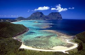 The Lord Howe Island Group, Tasman Sea. (Source: Australian Government: Department of the Environment and Water Resources)
 The preserve was established on 1 January 1982 under Section 19A of the Lord Howe Island (Amendment) Act, 1981. The Lord Howe Island Board was originally constituted under Section 4(1) of the Lord Howe Island Act, 1953. The entire island region was inscribed on the World Heritage List in 1982.
Area
Approximately 1,176 hectares (ha). The World Heritage Site includes the whole island region, covering approximately 1,540 ha of land area. The wider island group which includes Admirality Islands, Mutton Bird Islands, Balls Pyramid and associated coral reefs and marine areas covers 136,300 ha.
Land Tenure
State Government of New South Wales. All permanent private occupation is on leasehold from the government subject to various conditions.
Altitude
Sea level to 875 meters (m).
Physical Features
The main island of Lord Howe measures 10 km from north and south and is little more than 2 km in width. It roughly describes a crescent, enclosing a coral reef lagoon on its south-western side. The island's topography is dominated by the southerly Mount Gower (875 m) and Mount Lidgbird (777 m). Steep cliffs rise several hundred meters to form the seaward flanks of Mount Gower. Only a narrow isthmus of lowland country in the north-central part of the island is habitable. The northern tip consists of steep hillsides culminating in extensive sea cliffs against the northern coastline. Scattered around the main island are several groups of smaller islands and rocks. The most distant of these is a group of small islets and rock stacks around the 650 m pinnacle of Balls Pyramid, 25 km to the south-east of Lord Howe.
Lord Howe Island is the eroded remnant of a large shield volcano which erupted from the sea floor intermittently for about 500,000 years, 6.5 to 7 million years ago in the late Miocene. The island group represents the exposed peaks of a large volcanic seamount which is about 65 km long and 24 km wide and which rises from ocean depths of over 1,800 m. The Lord Howe seamount is near the southern end of a chain of such seamounts, mostly below sea level, extending for over 1,000 km. These mark the successive movement of the Australian tectonic plate over a 'hotspot' within the upper mantle below. Four separate series of volcanic rocks are recognized on the main island group, the oldest being exposed in the Admiralty Group and on the north-eastern tip of Lord Howe. These include tuffs, breccia and basalts, with widespread intrusion of basaltic dykes, and are overlain by progressively younger units to the south. The youngest volcanic rock is Mt. Lidgbird basalt, which is present in lava flows up to 30 m thick. Sedimentary aeolian calcarenite or dune limestone characterize the lowland parts of the main island.
The dominant landforming process on Lord Howe since the last of the volcanic eruptions has been marine erosion, which has cut and maintained major cliffs. Slope failure and accumulation of talus at the foot of some cliffs, especially in the south, have modified their original shape. Local variations in lithology are the major determinant of the shape of the irregular rocky coastline and of the small residual islands and rock stacks. There are numerous resistant projecting points and sea caves.
Subsequent erosion means that the present islands occupy only one-fortieth of the original area. Lord Howe Island has sedimentary deposits of Pleistocene and Holocene (Recent) age, including cross-bedded calcarenite with intercalated soil horizons, lagoonal deposits, a single sand dune, and alluvium. The island supports the southernmost true coral reef in the world, which is of Pleistocene to Recent age and differs considerably from more northerly warm water reefs. It is unique in being a transition between the algal and coral reef, due to fluctuations of hot and cold water around the island. The entire island group has remarkable volcanic exposures not known elsewhere, with slightly weathered exposed volcanics showing a great variety of upper mantle and oceanic type basalts. Ball's Pyramid represents the nearly complete stage in the destruction of a volcanic island. The intercalated soil horizons have yielded important palaeontological data, with interesting fossil finds such as the shells of land snail Placostylus and the terrestrial giant horned turtle Meiolania platyceps, which probably became extinct more than 20,000 years ago. A fossil bat skull, uncovered in 1972, has been described as a new species Nyctophilus howensis; it may have persisted into modern times.
Climate
Climate is humid subtropical with a mean temperature of 16°C in August and 23°C in February. Both diurnal and seasonal temperature range is about 7°C. A temperature of 0°C has been recorded on the summit of Mount Gower. Mean annual rainfall in the lowlands is almost 1,700 millimeters (mm), with a pronounced maximum in winter and a mean rainfall of 100 mm in February. The highest annual rainfall recorded in the lowlands is 2,870 mm, with a minimum of 1,000 mm. The southerly part of Lord Howe Island is generally wetter due to orographic effects. Relative humidity is high at 75-78% and wind levels average 13 knots in August, 9-10 knots in January and March.
Vegetation
A wide variety of vegetation types has been described for the islands, with the diversity corresponding with the range of habitats, viz. lowland, montane, valleys, ridges and areas exposed to the maritime influence. Variable exposure to wind and penetration of salt spray appear to be the main determinants of vegetation occurrence, structure and floristics. Lord Howe Island is almost unique among small Pacific Ocean islands in that its mountains have sufficient altitude for the development of true cloud forest on their summits. These are 241 native species of vascular plants on the island, including 105 endemics. Sixteen of these are considered rare, endangered (IUCN Red List Criteria for Endangered) or vulnerable. There are four endemic palm species in three endemic genera. There are also two other endemic genera in the families Asteraceae and Gesneriaceae. Other endemic species are widely scattered among families. Endemism is particularly noticeable among ferns and in the families Asteraceae, Myrsinaceae, Myrtaceae and Rubiaceae. There are 48 species of indigenous pteriodphytes (including 19 endemic ferns) belonging to 32 genera, and 180 species of angiosperms (56 endemics) in 149 genera. A further four species are represented by endemic subspecies or varieties; there are no gymnosperms. Some of the endemics suggest recent speciation, and many have confusing origins, such as the three endemic palm genera Howea, Hedyscope and Lepidorrhachis, and also Dietes sp., the three congeners of which are endemic to southern Africa and which has seeds with apparently only short range dispersal capacity. Other noteworthy endemics are Dendrobium moorei and Bubbia howeana. Many species are threatened or have restricted distribution on the island; there is only one known plant of non-endemic Pandanus pedunculatus, and Chionochloa conspicua ssp. nov. (Poaceae) is an endemic known only from one clump on Mount Lidgbird.
The vegetation has affinities with sub-tropical and temperate rain forests, and 129 plant genera are shared with Australia, 102 with New Caledonia (Biological diversity in New Caledonia) and only 75 with New Zealand. There are 160 naturalized, introduced plant species, mostly, but not exclusively, in the lowland settlement area. Weed species of the greatest immediate concern within the preserve are bone seed (biton bush), kikuya grass and asparagus fern Protoasparagus eathiopicus. Many other species are potentially serious problems.
Twenty-five vegetation associations in twenty alliances have been identified. Fourteen of these associations have endemic species as their dominant components. The slopes of the northern hills are dominated mostly by Drypetes/Cryptocaria rain forest, with Howea forsterana palm forest on the flats behind North Bay and H. belmoreana palm forest in the narrower gullies running down towards Old Settlement Beach. Melaleuca/Cassinia scrubs and Cyperus and Poa grasslands occur on the exposed slopes of Mount Eliza and along the crest of the sea cliffs on the northern coast. The southern mountains are covered with a more variable suite of rain forest and palm associations, often with Pandanus along drainage lines, and with scrub and cliff associations in the more exposed parts and along the coastline. Mutton Bird Point (on the east coast) and King Point (at the southern tip) have small occurrences of Poa grassland. The upper slopes of mounts Gower and Lidgbird include areas of forest dominated by another of the endemic palms, Hedyscepe canterburyana. The very humid summit plateau on Gower and the summit ridge on Lidgbird consist of structurally distinct gnarled mossy forest.
Fauna
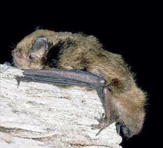 Eptesicus sagittula, otherwise known as the large forest bat, is the only indigenous native mammal known to be living in the Lord Howe Island Group. (Source: Museum Victoria)
 A small population of little cave eptesicus Eptesicus sagittula still occurs. No other indigenous native mammals are known. Introduced species, however, include mouse Mus musculus and rats Muridae, goat Capra hircus and, formerly, pig Sus domestica.
There are at least 129 native and introduced bird species, mostly vagrants, with 27 breeding regularly. Lord Howe is now the only known breeding ground for providence petrel Pterodroma solandri, although it also probably breeds on Ball's Pyramid. Fleshy-footed shearwater Puffinus carneipes hullianus breeds in substantial numbers on Lord Howe, with possibly half the world's population present. Other important species breeding within the preserve include Kermadec petrel Pterodroma neglecta, black-winged petrel P. nigripennis, wedge-tailed shearwater Puffinus pacificus, little shearwater P. assimilis, white-bellied storm petrel Fregetta grallaria, masked booby Sula dactylatra, red-tailed tropic bird Phaeton rubricauda in greater concentrations than probably anywhere else in the world. Sooty tern Sterna fuscata, noddy Anous stolidus and grey ternlet Procelsterna cerula. Several migratory wader species are regular visitors to the island, principally are double-banded dotterel Charadrius bicinctus, eastern golden plover Pluvialis dominica, turnstone Arenaria interpres, whimbrel Numenius phaeopus and bar-tailed godwit Limosa lapponica. Four endemic birds are present. Lord Howe Island woodhen Tricholimnas sylvestris, reduced to some 26 individuals in 1975, has been successfully bred in captivity and now numbers around 220. The other endemic land birds are silver-eye Zosterops tephropleura, Lord Howe Island golden whistler Pachycephala pectoralis contempta, both reasonably abundant. The Lord Howe Island currawong Strepera graculina crissalis is relatively common in the southern mountains, with lesser number found in the north.
The islands support two species of terrestrial reptile, skink Leiolopisma lichenigera and gecko Phyllodactylus guentheri, which are threatened with extinction on the main island but are abundant on other islands in the group. Many of the endemic invertebrates from the moss forest on the summit of Mount Gower have been collected and described. The small terrestrial gastropods (Hydrobiidae) comprises nine species and sixteen subspecies, a greater number of subspecies than those found on the eastern Australian mainland. The terrestrial molluscs have suffered from habitat changes; two colonies of large ground snails Placostylus sp. appear to be maintaining their numbers, though distinct forms seem to have become extinct on other parts of the island. There are five endemic species of flies (Diptera) and a further nine confined to Lord Howe and Norfolk Islands. Specimens of Lord Howe Island phasmid Dryococoelus australis (Ex), a large flightless phasmatid thought to be extinct on Lord Howe Island, is known to occur still on Ball's Pyramid. Over 50% of more than 100 species of spiders recorded for Lord Howe Island are thought to be endemic. One endemic species of leech and ten endemic species of earthworm have also been recorded. The terrestrial and freshwater (Freshwater biomes) crustacea are not well known, but include a freshwater crab Halicarcinus lacustris and a freshwater prawn Paratya howensis. Three new genera and 12 new species of terrestrial isopod have been recorded and recently anew species of talitrid amphipod from the top of Mount Gower was described. The waters around Lord Howe Island provide an unusual mixture of temperate and tropical organisms, 477 fish species having been recorded in 107 families of which 4% are unrecorded elsewhere other than in Norfolk Island-Middleton Reef waters. Lionfish Pterois volitans is protected in the marine waters.
Cultural Heritage
The earliest European discovery of Lord Howe appears to have been in 1788 by the British colonial vessel HMS Supply. There is no recognized evidence of prior Polynesian or Melanesian discovery or settlement. A small permanent settlement was established in the 19th century, subsisting on trade with passing ships. With numerous fluctuations over the years, the settlement slowly expanded and consolidated, developing a distinctive social structure and culture with the passage of time. The island is an interesting example of restricted island settlement, although the World Heritage nomination was not made on cultural grounds.
Local Human Population
There is currently a resident population of approximately 300 individuals inhabiting the relatively level ground in the central part of the main island. Tourism is the major component of the island economy, followed by public administration and community service. Approximately 10% of the main island's vegetation has been cleared for agriculture, and another 10% has been subject to physical disturbance. Commercial activities within the preserve include collection of palm seed, especially Kentia palm Howea forsterana and cutting of Pandanus foliage for production of baskets and other craft items, subject to control by the Lord Howe Island Board.
Visitors and Visitor Facilities
Some three to four hundred tourists may be present simultaneously during the summer, although neither the annual total number of visitors, nor the revenue derived from tourism is known. The principal means of access to the island for visitors is by light aircraft. There are four licensed guest houses providing full board accommodation and 13 self-contained apartment complexes. Walking, often for nature study, bird watching or photography, is the major recreation activity. There is an extensive system of walking tracks ramifying throughout the reserve and a guide service is available. Scenic flights are available over the entire island group and several commercial operators offer boat tours. Proposed interpretation and environmental education activities are outlined in the current management plan.
Scientific Research and Facilities
There has been considerable scientific interest in Lord Howe ever since discovery of the island. A succession of scientific expeditions in the 19th century quickly established the international significance of the island's natural history. In the early 1970s the Australian Museum undertook a terrestrial environmental survey of the island for the Lord Howe Island Board which included inter alia a recommendation to establish an extensive land reserve for the protection of terrestrial flora and fauna. Land use planning studies undertaken for the Board also recommended the establishment of a substantial reserve on the island. A major research project culminated in the successful captive breeding of Lord Howe Island woodhen in the early to mid-1970s.
Conservation Value
The Lord Howe Islands Group was inscribed on the World Heritage List for its unique landforms and biota, its diverse and largely intact ecosystems, natural beauty, and habitats for threatened species.
Conservation Management
The affairs, care, control and management of Lord Howe Island, including the smaller islands offshore, are administered by the Lord Howe Island Board. The Lord Howe Island (Amendment) Act, 1981, reconstituted the Board, such that one of its members is an officer of the New South Wales National Parks and Wildlife Service, nominated by the Minister administering the 1974 National Parks and Wildlife Act. Section 15B of the amended Act provides for the preparation of a management plan in respect of the preserve, prepared by the Director of Parks and Wildlife, in terms of Part V of the 1974 Act. The plan is to be approved by the Minister administering the Lord Howe Island Act. The Board has adopted a "land use policy set", based on a model that proposes that the region comprises two components: the settlement area, and the preserve. One of the objectives of the land use policy set is "to ensure that the management plan for the settlement area will complement the future permanent park preserve plan of management and form a plan of management for the island as a whole".
The Lord Howe Island management plan states that the fundamental management objectives are to: maintain the natural land-forming processes; protect significant landforms; maintain natural plant and animal [[population]s]; avoid all unnatural disturbances of plant associations and habitats; protect all individuals and the population of each species from unnatural disturbances; eliminate human disturbance; restore disturbed areas; control or eliminate introduced species; preserve outstanding natural scenery and natural character of the preserve; promote appreciation and enjoyment of the preserve; maintain the full range of plant genetic diversity; and make provision for continued livelihood of the local populace. Specific management activities have included the elimination of goats from the Northern Hills, resulting in substantial recovery of the understorey and a severe reduction in the number of feral pigs. Pigs are reported to have subsequently been eliminated. Funds and labor have been allocated to an intensive effort to control weed infestations and feral animals affecting native vegetation and birds. However, funding and labor constraints have so far only allowed the control, and not elimination, of introduced flora and fauna. The Board is seeking Commonwealth Government funding in order to fully implement the eradication program.
Management Constraints
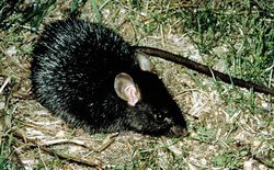 Introduction of Rattus rattus, the black rat, has created problems of species extinction in the Lord Howe Island Group. (Source: Museum Victoria)
 Nine of the fifteen species of land birds recorded when the Island was first discovered are now extinct, of which seven were endemics. Their destruction has been due to hunting, introduction of black rat Rattus rattus, owls and feral cats, or through habitat changes caused by introduced goats and pigs. The size of some seabird colonies on the main island has also declined. Endemic land snails are less abundant and confined to isolated colonies although exact details are not known, and the two lizards are very restricted if not extinct on the main island. There are 175 introduced species of plant, although most of these have not invaded the indigenous plant communities. In the lower-lying areas, destruction of native vegetation has been virtually complete where clearings have been made for settlement, grazing and agriculture, and regrowth tends to be of invading weed species, including introduced plants such as guava, bitou bush, ferny asparagus and asparagus fern. However, adequate samples of intact lowland vegetation remain in less accessible parts of the island, some of them in special flora reserves.
Staff
No information.
Budget
Approximately 10% of the Board's budget is committed annually to environmental protection.
IUCN Management Category
- II (National Park)
- Natural World Heritage Site - Criteria iii, iv
Further Reading
- Anon. (1969). Climatic averages Australia temperature, relative humidity and rainfall. Bureau of Meteorology, Melbourne (sic).
- Anon. (1974). Australian Natural History 18(2), June. (Entire issue devoted to Lord Howe Island). (Unseen)
- Anon. (1989) Information update on the cultural sites inscribed on the World Heritage list: Lord Howe Island Group. Department of the Arts, Sport, the Environment, Tourism and Territories, Canberra. Unpublished. 3 pp.
- Ashton, N. (1974). Report to the Lord Howe Island Board on the future land use and land management of Lord Howe Island. Sydney, State Planning Authority of New South Wales. (Unseen)
- Australian National Parks and Wildlife Service. Nomination of the Lord Howe Island Group for inclusion in the World Heritage List. New South Wales Government. 30 pp.
- Brown, I. (1979). Birds of Ball's Pyramid, Lord Howe Island. Australian Birds 13(3): 41-42. (Unseen)
- Davey, A. (1986). Plan of management: Lord Howe Island Permanent Park Preserve. New South Wales National Parks and Wildlife Service, Sydney. 118 pp.
- DEST/ERIN (1995). Lord Howe Island Group. Managed Area Report. Department of the Environment, Sports and Territories/Environmental Resources Information Network, Australia.
- Disney, H.J. and Smithers, C.N. (1972). The Distribution of Terrestrial and Freshwater Birds on Lord Howe Island, in comparison with Norfolk Island. The Australian Zoologist 17(1). (Unseen)
- Elenius, E. (1979). Lord Howe Island - World heritage threatened. National Parks Journal 13: 13-14. (Unseen)
- Gentilli, J. (1971). Climates of Australia and New Zealand. In: World Survey of Climatology Volume 13. Elsevier, Amsterdam.
- McDougall, I., Embleton, B.J.J. and Stone, D.S. (1981). Origin and evolution of Lord Howe Island - South-west Pacific Ocean. Journal of the Geological Society of Australia 28: 156-176. (Unseen)
- McKean, John L. (1975). The Bats of Lord Howe Island with the description of a new Nyctophiline bat. Journal of the Australian Mammal Society 1(4): 329-332. (Unseen)
- Miller, B. (1981). Liberate the woodhen, the theme of the '80's. 'Napawi' Staff Newsletter of the National Parks Wildlife Service, NSW (2): 17-19. (Unseen)
- Miller, B. and Kingston, T. (1980). Lord Howe Island Woodhen. Endangered Species of New South Wales. National Parks and Wildlife Service. (Unseen)
- NPWS (n.d.). Walks and tours: Mount Gower Walk. New South Wales National Parks and Wildlife Service, Sydney. Leaflet. 2 pp.
- Paramonovs, S.J. (1958). Pacific Science 12: 82-91. (Unseen)
- Paramonovs, S.J. (1960). Pacific Science 14: 75-85. (Unseen)
- Paramonovs, S.J. (1963). Pacific Science 17: 361-373. (Unseen)
- Pollard, D.A. (1977). A proposed Lord Howe Island Marine Reserve: Protecting the southernmost coral reef in the World. Collected Abstracts and Papers of the International Conference on Marine Parks and Reserves, Japan. (Unseen)
- Pickard, J. (1983). Vegetation of Lord Howe Island. Cunninghamia 1: 133-266. (Unseen)
- Pope, E.C. (1960). Australian Museum Magazine 13(7): 207-210. (Unseen)
- Rabone, H.R. (1972). Lord Howe Island - Its discovery and early associations 1788-1888. Sydney, Australia. (Unseen)
- Randall, J.E. (1975). Lord Howe Island, a land and sea preserve. Proceedings of the First World Conference on Marine Parks and Reserves, Tokyo, Japan. (Unseen)
- Recher, H.F. and Clark, S.S. (1974). A biological survey of Lord Howe Island with recommendations for the conservation of the island's wildlife. Biological Conservation 6(4): 263-273. (Unseen)
- Recher, H.F. and Clark, S.S. (1974). Environmental survey of Lord Howe Island. A Report to the Lord Howe Island Board. Australian Museum. (Unseen)
- Rodd, A.N. (1981). Field Trip 17 Lord Howe Island Handbook, produced for the XIII International Botanical Congress, Sydney. (Unseen)
- Standard, J.C. (1963). Geology of Lord Howe Island. Journal and Proceedings of the Royal Society of New South Wales 96: 107-121. (Unseen)
- Thompson, D, Bliss, P. and Priest, J. (1987). Lord Howe Island geology. Lord Howe Island Board, Sydney. Brochure.
- Waterhouse, D.R. (1976). A new national park in the Pacific. Tigerpaper (3)1.
| Disclaimer: This article is taken wholly from, or contains information that was originally published by, the United Nations Environment Programme-World Conservation Monitoring Centre (UNEP-WCMC). Topic editors and authors for the Encyclopedia of Earth may have edited its content or added new information. The use of information from the United Nations Environment Programme-World Conservation Monitoring Centre (UNEP-WCMC) should not be construed as support for or endorsement by that organization for any new information added by EoE personnel, or for any editing of the original content. |