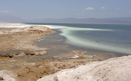
Lake Assal
Lake Assal, located in east-central Djibouti, is the largest hypersaline lacustrine water body in Africa. This crater lake is classified as a thalassohaline body, meaning it is dominated by sodium and chloride, reflecting the ionic composition of ocean waters; Lake Assal is an endorheic basin, implying it has no flow outlet, so that salinity is concentrated as massive evaporation proceeds in this hot arid climate.
The lake shoreline's rich salt deposits have been exploited since prehistory, but the magnitude of present day harvesting has exploded since independence from France, damaging the shorelinenatural features. Not only did prehistoric hominins inhabit the Lake Assal basin, but they engaged in very productive Paleolithic toolmaking manufacture, in addition to advanced pick-axe designs for extracting the salt resource.
Contents
Geography
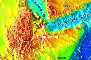
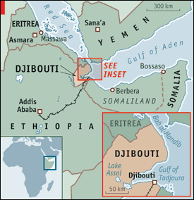 Regional setting of Lake Assal. Source: Public domain
Lake Assal is a crater lake situated near the western end of Gulf of Tadjoura, which is a bay of the Indian Ocean along the Horn of Africa. This endorheic setting is known as the Afar Depression. A neck of land separates the lake from the Gulf of Tadjoura, which narrow landform, was likely earlier absent, yielding a prehistoric connection of Lake Assal with the ocean. This crater lake lies within the nation of Djibouti, previously within the territory of the previous French Somaliland. With a lake surface elevation of 155 meters below mean sea level, Lake Assal is the lowest elevation point of the African continent and one of the lowest altitude lakes of the world.
Geology and Formation
Lake Assal sits over a volcanic basaltic basement with a depth of about 255 meters below present day mean sea level. Lying immediately above that basalt are the next oldest formations, consisting of fifteen meter thick freshwater deposits: marls, tufas and calcretes; Fossil organisms dominant in these freshwater formations are the freshwater snail red-rimmed melania (Melanoides tuberculatus) and species of the freshwater bivalves of the genus Coelatura. Immediately above the freshwater layer is a layer of marine deposition which is evidenced by fossils of marine gastropods of the genera Cerithium and Ervilia. This layer clearly suggests a marine invasion of an earlier freshwater lake.
Immediately overlying the marine deposition layer is a diatomaceous layer characterized by fossilized species of the genus Navicula, a taxon of boat shaped phytoplankton. Above the diatom layer is a gypsum layer; finally, the top geologic layer is rock salt that forms the present day lake bottom. The lake depth averages about 7.4 meters, with a maximum depth to rock salt of approximately 45 meters.
About three kilometers distant is the active Ardoukôba fissure vent volcano.
There are two main theories of the formation of Lake Assal, one being that the neck of land severing the lake from the Gulf of Tadjoura was formed by volcanic eruption.
The alternate theory is that of sea level rise in the face of lower prehistoric coastal terrace topography. A variation of this marine invasion theory is that subsurface marine springs being fed by Indian Ocean waters. This theory is supported by the fact that such subsurface springs are the chief mechanism of water influx to the lake at the present time. This springwater influx arrives at a flow rate of approximately four to eight thousand cubic meters per second.
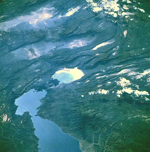 Satellite view of Gulf of Tadjoura (lower left) and Lake Assal (center).
Source: NASA
Presently much of the land around Lake Assal, including the neck of land separating it from the Gulf of Tadjoura, consists of an almost barren landscape of relatively recent black lava. There are actually active volcanic vents on that neck of land separating the lake from the gulf, explaining the source of heat that warms the subsurface gravity fed channel of seawater feeding the lake. Lake Assal and the head of the Gulf of Tadjoura trend north-northwest are aligned with an active rift zone of the approximate size as the spreading centers along the Mid-Atlantic Ridge. In examining space platform photographs, one sees the breadths of shadows along fault scarps as clear insights as to the extent of vertical offset for each fault. In the NASA satellite photo (right), the dramatic cliff in shadow at the north side of Lake Assal measures 1230 meters in height.
Hydrology and Water Chemistry
The chief feed of Lake Assal is geothermal subsurface spring water, which is actually a conduit through basaltic structures that intervene between the Gulf of Tadjoura and the lake itself. This influx has very similar chemistry and salinity as the seawater itself, having little alteration during its five kilometre route in the subsurface channel; however, the influent water has become heated with contact of the geothermal basaltic formations.
Lake Assal's total catchment area is approximately 900 square kilometres. Lake dimensions are approximately: seven kilometers maximum width and 19 kilometers maximum length. Minimal surface runoff of freshwater occurs in the watershed, and is limited to that generated from sporadic rainfall producing ephemeral streams; in other words, there are no permanent rivers in the watershed. This intermittent flow regime impacts the lake via salt pan inundation.
Because of the robust stream of subsurface gulf water feeding Lake Assal, it is not surpsrising that the ionic composition of the lake somewhat mimics that of ocean waters. Chief anion concentrations in the lake are approximately as follows in grams per liter: Na+, 78; K+, 5; Mg+2, 8; and Ca+2, 15. Principal cation concentrations correspondingly in grams per liter are: Cl-, 181; SO4-2 2; and Br- 5. The surface concentration of salts is about 276.5 g/L for Lake Assal. Bottom waters are about ten percent higher in salinity.
Aquatic Ecology
Compared to other major world lakes, there is a paucity of ecological information for Lake Assad. A number of taxa of halophilic bacteria and extremely halophilic archaea have been found here. Indirect evidence for microbial presence is also suggested by the evaporites of the lake, which crystals are often occur as salt ooids having a radial concentric structure, suggestive of microbially assisted crystallization. Specific aerobic bacteria taxa isolated in the lake include species of the genera micrococcus and staphylococcus.
Due to the lake's hypersalinity, there are no fish, amphibians or other higher faunal lifeforms here. The immediate shoreline and backshore area are also almost devoid of plants and higher fauna, because of the salt deposits and hypersaline soil perimeter. However, this absence of apparent life may be misleading, in that future researchers may find this entire lake and its perimeter a laboratory for discovering extremophile lifeforms, much like the overtly biologically depauperate San Juan Pond in Antarctica has become an exemplar Earth laboratory for trying to understand the unconventional lifeforms that might be present on Mars.
Terrestrial Ecosystem
See main article: Ethiopian xeric grasslands and shrublands
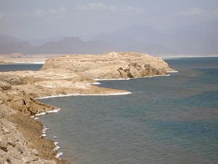 Biologically depauperate rocky shoreline of Lake Assal.
Source: C.D.Fisher/Creative Commons
This ecoregion as a whole extends inland from the Red Sea and the Gulf of Oman, including the Dahlak Archipelago and other islands, stretching from the Sudanese-Eritrean border, south through Djibouti, it mainly lies between sea level and 800 meters (m). There are also fault-induced depressions, such as the Danakil Depression and Lac Assal itself (the earlier French name)
The region is currently extremely active tectonically, and it experiences frequent seismic events associated with the continuing enlargement of the Rift Valley. Volcanoes in the ecoregion are also intermittently active. Basement rocks are composed mainly of Tertiary lava flows. Soils developed over the lava deposits are mainly lithosols, while regosols are predominant on the Quaternary and pre-Cretaceous basinal deposits. There are very few permanent watercourses.
The climate is very hot and dry. Mean annual rainfall varies from less than 100 mm close to the coast to around 200 mm further inland. Mean minimum temperatures range from 21° to 24°C, and mean maximum temperature is around 30°C. Inland, near Lake Assal, vegetation is chiefly grass shrub steppe. Acacia mellifera and Rhigozum somalense dominate the basaltic lava fields while scattered Acacia tortilis,A. nubica, and Balanites aegyptiaca can be found in the sandy plains. Stands of Hyphaene thebaica occur in depressions and along wadis(streams).
Among mammals, desert ungulates are well represented. Beira antelope (Dorcatragus megalotis, Vulnerable) occur in the region where Djibouti, Ethiopia, and Somalia meet. Dorcas gazelles (Gazella dorcas,Vulnerable), Soemmerring's gazelles (Gazella soemmerringii, Vulnerable), Salt’s dikdik (Madoqua saltiana), and gerenuks (Litocranius walleri) all still occur in the general area. Beisa oryx (Oryx beisa) persist, but have been greatly reduced by hunting pressure.
The reptilian fauna is relatively rich, but there are very few amphibians. Levels of endemism are generally low, with strict endemics limited to only one bird, Archer’s lark (Heteromirafra archeri,Vulnerable), a gerbil Gerbillus acticola, and two geckos, Arnold’s leaf-toed gecko (Hemidactylus arnoldi) and a subspecies of the northern sand gecko (Tropiocolotes tripolitanus somalicus). Among the plants, dragon ombet (Dracaena ombet, EN) and Bankoualé palm (Livistona carinensis,Vulnerable) are notable.
Prehistory
Rich finds of pristine looking Late Neolithic stone pick-axes have been found on the neck of land that divides Lake Assal from the gulf. Archaeologists properly reasoned that the picks lacked much damage, since they were likely used for extraction of the salt deposits along the shoreline of Lake Assal. Along the eroded gravelly surface of the neck landform were also recovered an extensive collection of prehistoric discs, cores and flakes; the weathered conditions of these artifacts suggest an age even earlier than the pick-axes.
The most remarkable aspect of this large assembly of Paleolithic flakes and other worked tools was the clear evidence of Levallois technology, a manufacturing process usually associated with Neanderthal culture. This discovery suggests Neanderthals, who thrived 300,000 to 30,000 years before present were active further south than the Levant, a generally ascribed southern limit of Neanderthal culture. A further southern migration may have occurred during the rapid Earth cooling at the end of the Eemian period, when glaciation conditions further north may not have been hospitable. It is important to note the Levallois tools were corroborated in excavations at Obok and in the Mabla Mountains, both sites to the north of the Gulf of Tadjoura.
Nomadic tribes of the Afar people drove their camels along the salt laden shores of Lake Assal, thus creating the alignment of an ancient caravan drovers road in the region. This route linked Lake Assad to Ethiopian mountain regions to trade salt, coal and sorghum. Trade routes extending to Abyssinia also conveyed not only commodites such as ivory and coffee, but also traffic in human slavery.
References
-
 Regional setting of Lake Assal from space. Source: NASAAharon Oren. 2002. Halophilic microorganisms and their environments. Springer. 575 pages
 - Chase Bertus. Africa: history, geography, people. Publisher: Forgotten Books
- The prehistoric cultures of the Horn of Africa. 1951. Cambridge University Press
- Russell H.Vreeland and Lawrence I.Hochstein. 1993. The Biology of halophilic bacteria. CRC Press. 320 pages
- John K.Warren. 2006. Evaporites: sediments, resources and hydrocarbons. Birkhäuser. ISBN 9783540260110
- F.White. 1983. The vegetation of Africa, a descriptive memoir to accompany the UNESCO/AETFAT/UNSO Vegetation Map of Africa (3 Plates, Northwestern Africa, Northeastern Africa, and Southern Africa, 1:5,000,000). UNESCO, Paris. ISBN: 9231019554
- World Wildlife Fund. 1998. A conservation assessment of terrestrial ecoregions of Africa: Draft proceedings of a workshop, Cape Town, South Africa, August C1998. World Wildlife Fund, Washington, DC, USA.
