Water profile of Jordan
The water profile of Jordan is dominated by systematic unsustainable overdrafting of groundwater and extraction of surface water. Principal overexploitation of water has been occurring in the Jordan River Valley, with resultant delcine in the level of the Dead Sea and in the Jordan Valley.
Contents
Geography and Population
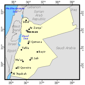
Jordan, with a total area of about 89,210 square kilometers (km2), lies to the east of the Jordan river and is divided into eight governorates: Amman, Zarqa, Irbid, Mafraq, Balqa, Karak, Tafileh, and Ma'an. It is bordered in the north by Syria, in the northeast by Iraq, in the southeast and south by Saudi Arabia, in the far southwest by the Gulf of Aqaba (northern shores of the Red Sea), and in the west by Israel.
The country can be divided into four physiographic regions:
- The Ghors (lowlands) in the western part of the country, which consist of 3 zones: the Jordan valley which starts at Lake Tiberias in the north (220 meters (m) below sea level), the lowlands along the Dead Sea (405 m below sea level) and the Wadi Araba which extends in a southerly direction to the northern shores of the Red Sea (total area: 5000 km2);
- The highlands, which run from north to south at an altitude of between 600 and 1600 m above sea level (total area: 5510 km2);
- The plains, which extend from north to south along the western borders of the desert (Badiah) (total area: 10,000 km2);
- The desert region (Badiah) in the east, which is an extension of the Arabian desert (total area: 68,700 km2).
The cultivable land was estimated at 381,740 hectares (ha) in 1992, or 4.3% of the total area of the country. In 1991, the total cultivated area was estimated at 214,767 ha, which is about 56% of the cultivable area, of which 120,077 ha consisted of annual crops and 94,690 ha consisted of permanent crops. In addition, each year up to 50,000 ha of rainfed land can be left fallow due to fluctuating and unevenly distributed annual rainfall.
The total population is almost 5.5 million (1995), of which 29% is rural. The population growth is estimated at 3.4% not including fluctuations caused by international political events. Currently, about 90% of the population is concentrated in the northwest quadrant of the country, where rainfall is highest and where most of the water resources are located. Agriculture accounted for 6% of Jordan's gross domestic product (GDP) in 1992 and for 12% of its exports earnings, mainly fruits and vegetables, in 1991. In 1992, 10% of the labor force were employed in agriculture.
Climate and Water Resources
Climate
The climate in Jordan is characterized by a long, dry, hot summer, a rainy winter and a drier-than-spring autumn. The temperature increases towards the south, with the exception of some southern highlands. Rainfall varies considerably with location, due mainly to the country's topography. Annual rainfall ranges between 50 millimeters (mm) in the eastern and southern desert regions to 650 mm in the northern highlands. Over 90% of the country receives less than 200 mm of rainfall per year. Average annual rainfall for the country as a whole gives a total volume of 8.43 cubic kilometers (km3).
Surface Water Resources
Surface water resources are unevenly distributed among 15 basins. The largest source of external surface water is the Yarmouk river, at the border with Syria. Originally, the annual flow of the Yarmouk river was estimated at about 400 million m3 (of which about 100 million m3 are withdrawn by Israel). Total flow is now much lower than 400 million m3 as a result of the upstream Syrian development works which were done in the 1980's. The Yarmouk river accounts for 40% of the surface water resources of Jordan, including water contributed from the Syrian part of the Yarmouk basin. It is the main source of water for the King Abdullah canal and is thus considered to be the backbone of development in the Jordan valley. Other major basins include Zarqa, Jordan river side wadis, Mujib, the Dead Sea, Hasa and Wadi Araba. Internally generated surface water resources are estimated at 400 million m3/year.
Groundwater Resources
Jordan's groundwater is distributed among 12 major basins. Total internally produced renewable groundwater resources have been estimated at 500 million m3/year, of which 220 million m3 constitute the base flow of the rivers. Groundwater resources are concentrated mainly in the Yarmouk, Amman-Zarqa, and Dead Sea basins.
The safe yield of renewable groundwater resources is estimated at 275 million m3/year. Most of it is at present exploited at maximum capacity, in some cases beyond safe yield. Of the 12 groundwater basins, 6 are being overextracted, 4 are balanced with respect to abstraction and 2 are under-exploited. Average groundwater depletion was estimated at 190 million m3/year in 1990. Over-extraction of groundwater resources has degraded water quality and reduced exploitable quantities, resulting in the abandonment of many municipal and irrigation water well fields, such as in the area of Dhuleil.
The main non-renewable aquifer presently exploited is the Disi aquifer (sandstone fossil), in southern Jordan with a safe yield estimated at 125 million m3/year for 50 years. Other nonrenewable water resources are found in the Jafer basin, for which the annual safe yield is 18 million m3. In total it is estimated by the Water Authority of Jordan that the safe yield of fossil groundwater is 143 million m3/year.
Dam Capacity
Total dam capacity in Jordan is estimated at 143 million m3, including the desert dams. The largest dam (the King Talal dam on the Zarqa river) has a total capacity of 80 million m3. The other main dams are located on the Wadis Araba (20 million m3), Ziglab (4.3 million m3), Kafrein (3.8 million m3), and Shueib (2.3 million m3). The proposed design of the Wahda (Unity) dam on the Yarmouk river, following a treaty between Jordan and Syria, allows for a dam of 100 m in height with a gross storage capacity of about 230 million m3. Another proposed dam is the Karameh dam on Wadi Mallaha with a gross storage capacity of 55 million m3. Following the signature of the Peace Treaty with Israel (1995), investigations have been initiated to assess the need for future storage facilities on the Jordan and Yarmouk rivers.
Wastewater
The produced wastewater was estimated at 232 million m3/year in 1993 and the quantity of reused treated wastewater reached 50 million m3, of which 48 million m3 for irrigation and 2 million m3 for industrial purposes. The reuse of treated wastewater in Jordan reaches one of the highest levels in the world. The treated wastewater flow in the country is returned to the Search river and the King Tall dam, where it is mixed with the surface flow and used in the pressurized irrigation distribution system in the Jordan valley. The importance of reused wastewater is an essential element of Jordan's water strategy.
Water Withdrawal
In 1993, total annual water withdrawal was estimated at 984 million m3, up from 619 million m3 in 1986. Agricultural water withdrawal accounted for 74.9% of the total water withdrawal (73.9% for agriculture and 1% for livestock, industrial, and domestic use accounted for 3.4% and 21.7%, respectively) including the use of treated wastewater. Due to limited and widely scattered sources of water, the construction of important water conveyance facilities was undertaken between 1962 and 1987 in order to meet the demand of the population which is concentrated in some areas. Some shortages have been observed during recent years, but they are generally limited to less than 10% of the demand. However, during the dry year of 1990, the water shortage affected 17% of the water demand.
Environment
The level of the Dead Sea falls each year by 85 centimeters (cm) due to extensive water use in the Jordan basin. Irrigated soils along the Jordan valley are showing signs of salinization since natural floods are no longer available to flush the irrigated land and leach salts.
International Rivers
Most of Jordan's water resources are shared with other countries. The Jordan river is the largest river of the country, where water allocation to riparian countries is one of the most difficult regional issues. Failure so far to develop a unified approach to managing these water resources has encouraged unilateral development by the various riparian countries. Other important shared water resources are the groundwater resources of North Jordan (the Azraq, Yarmouk, and Amman-Zarqa basins), where a significant percentage of the natural recharge probably occurs in Syria. Additional Syrian development of groundwater in these basins would endanger current Jordanian development and greatly reduce the safe yield available to Jordan.
The Yarmouk/Jordan river system is the main surface water resource. Given the extreme scarcity of water resources in the region, the importance of developing acceptable water resources allocation strategies was recognized as early as the 1930s. Although no comprehensive agreement exists on sharing the jointly-owned water resources, eleven plans for water use were prepared between 1939 and 1955. The last one was the Johnston Plan of 1955, allocating water between Jordan and Syria.
Irrigation and Drainage Development
The potential for irrigated cultivation is estimated at around 840,000 ha. However, taking into consideration potentially available water resources, the irrigation potential is about 85,000 ha, including the area currently irrigated.
Although irrigation has been reported in Jordan for a very long time, particularly in the Jordan valley, intensive irrigation projects have been implemented since 1958 when the Government decided to divert part of the Yarmouk river water and constructed the East Ghor canal (later named King Abdullah canal). The canal was 70 km long in 1961 and was extended three times between 1969 and 1987 to reach a total length of 110.5 km. The construction of dams on the side wadis and the diversion of the flows from other wadis has allowed the development of irrigation over a large area. At the same time, wells were drilled in the Jordan valley to abstract groundwater, not only for domestic purposes but also for irrigation.
Apart from in the Jordan valley, irrigation is also reported in the highlands, mainly dependent on groundwater resources. The irrigation system here relies on wells, from 100 to 5,000 m deep, and pumps which deliver water to the agricultural land. There are three types of irrigated farming entities in these areas:
- private holders who have received loans from the ACC (Agriculture Credit Corporation) for drilling, pumps, and farm irrigation systems;
- Bedouin-settlement irrigation projects operated and maintained by the Ministry of Agriculture and the Water Authority;
- Private companies operating large-scale projects in the southeast of the country.
In 1995, the total area equipped for irrigation was estimated at 72,850 ha; in 1991, it was 64,300 ha (38,300 ha under micro-irrigation, 5,700 ha under sprinkler irrigation). One of the main sources of water is the King Talal dam on the Zarqa river from which water is diverted into the King Abdullah canal. Irrigation water was originally distributed by open canals. This design was changed to reduce losses and all new developed zones have been provided with pipe systems. The techniques used by farmers have gradually changed from surface irrigation (furrow and basin) to micro-irrigation.
In 1992, it was estimated that about 55% of the area was irrigated from groundwater, 39% from surface water and 6% from treated wastewater. The Disi irrigation project, one of the largest schemes in Jordan covering a total area of 3,000 ha, is supplied with fossil groundwater.
In 1991, two different types of schemes coexisted in Jordan:
- In the Disi-Mudwara area, the schemes larger than 1,000 ha cover a total area of 6,400 ha. They are owned by large companies. In total, about 1,000 households are working on these schemes. All water is pumped from groundwater and no water charge exists. The average cost of development of such an irrigation project is estimated at $US 30,000 (e.g. the government's investments in the Ghors), while annual operation and maintenance costs can reach $US 4,800/ha.
- The small schemes, generally less than 10 ha each, cover a total area of 57,900 ha.
The total number of beneficiaries is 250,000 households considering only the Jordan valley. The price charged for irrigation water has been $US 11.4 every 1,000 m3 since October 1994 (it was only $US 8.6 previously). The average cost of irrigation development for the production of vegetables varies between $US 6,000 and 9,000/ha and the annual average operation and maintenance costs are about $US 4,800/ha.
The main crops grown in Jordan are wheat and barley (used largely as animal feed), which are generally rainfed. In 1991, irrigated cereals covered an area of 8,890 ha, of which 6,320 ha was wheat and 2,570 ha barley. The average yield for irrigated wheat was 3.5 tons per hectare (tons/ha) in the case of supplementary irrigation and up to 6 tons/ha under permanent irrigation in southeastern areas. The yield of rainfed wheat varied between 0.7 and 1.4 tons/ha. The yield of irrigated barley was 2.5 tons/ha as against 0.6 tons/ha for rainfed barley.
The major irrigated crops are vegetables, fruit trees, and olives. The cropping intensity of irrigated annual crops is 112%. Vegetables covered a total area of 36,120 ha in 1991 of which 80% was irrigated. They contributed on average 30% to the total gross value of agricultural production during the period 1980-1990. They also remain the highest contributor to food exports, providing 58% of total food exports in 1990. In 1991, olives occupied 67,880 ha with about 20% irrigated, and fruit trees occupied 26,810 ha with over 50% irrigated. Irrigation covers 80% of the total agricultural production.
In 1992, drainage existed on about 4,000 ha of the irrigated area, mainly through open drains, and all by gravity. The average cost of drainage development is estimated at $US 2,000/ha.
Institutional Environment
The following ministries/institutions are involved in the water sector in Jordan:
- The Ministry of Water and Irrigation (MOWI), with the Water Authority of Jordan (WAJ) and the Jordan Valley Authority (JVA) as its operational entities
- The Ministry of Agriculture
- The National Center for Agricultural Research and Technology Transfer
- The Ministry of Municipal and Rural Affairs and the Environment (MMRAE)
- The Water and Environment Research and Study Center
The Ministry of Water and Irrigation is the body responsible in Jordan for the formulation and implementation of water and wastewater development programs. A policy package, covering all aspects of the water sector, was in preparation in 1995.
Municipal water use was made more systematic with the creation of the Water Authority in 1985. Prior to that, many agencies and municipalities were responsible for the production and distribution of municipal water.
A land and water settlement law (No. 40) was enacted to distribute water among farmers. Water is distributed by shares, with each dunum (equivalent to 0.1 hectare) situated on a source having one share. In some cases, water is broken into time units known as fasl. The fasl allows the farmer to use the entire flow of water from a channel for a fixed time, usually 3, 6 or 12 hours.
Trends in Water Resources Management
Jordan's past economic development plans reveal that surface water resources have been extensively developed by the Government, with priority given to the construction of dams and irrigation projects in the Jordan valley in order to maximize the utilization of this resource before its drainage to the Dead Sea. Limited additional untapped surface water resources could be developed in the Jordan valley side wadis and in the Mujib, Zarqa, Ma'an, and Zara basins, subject to specific conditions.
It is no surprise that future trends in irrigation are closely linked to water development possibilities. Aquifers in the Disi-Mudwara, Jafer, and Hamad areas are prime fresh water sources, able to supply an additional 80 million m3/year of water for 100 years. Full utilization of these resources would require adequate management practices to avoid salinization and should be accompanied by reducing extraction from over-utilized aquifers. Plans are under way for a better assessment of the Hamad and Al-Sarhan basins' potential.
Jordan, Israel, and the West Bank are presently over-exploiting their water resources by between 10% and 20%. Water levels are dropping, groundwater resources are being mined, salinization and salt water intrusion are observed and the domestic water supply does not reach adequate standards. The following actions are envisaged to remedy this crisis:
- reduction of water demand for irrigation
- importation of water from water-rich countries like Turkey
- desalinization of sea water
As part of the efforts towards joint management of water resources, the Jordanian-lsraeli Peace Treaty includes the following arrangements:
- 20 million m3 of Yarmouk water will be stored by Israel in the winter and released to Jordan in the summer;
- 10 million m3 will be released from the Tiberias lake outside the summer season for Jordan until the construction of a desalinization plant;
- construction of storage facilities on the Yarmouk and Jordan rivers and groundwater potential in wadi Araba are under investigation;
- 50 million m3 of drinking water should be further allocated to Jordan through cooperation between both parties.
Although the potential for irrigation development in the highlands is great, a very small increase in irrigated agriculture is anticipated due to the unavailability of water resources. The average water consumption for irrigation in the Jordan valley and southern Ghor is less than 10,000 m3/ha per year, which is much less than in the highlands where it reaches on average 16,000 m3/ha per year. This may be due to the fact that in the highlands irrigation water is mostly groundwater pumped individually by farmers with less supervision than in the Jordan valley where the Jordan Valley Authority controls the delivery of water.
Some of the water resources which would be made available for irrigation purposes are recycled water from municipal wastewater treatment plants. The total quantity of reused treated wastewater is expected to grow from 50 million m3 in 1993 to about 89 million m3 in 2000 and 237 million m3 in 2020.
If the Jordan valley plans to improve water use efficiency through conversion from surface to pressurized irrigation networks, it is expected that this will increase the available water resources by 25 million m3/year. Future development of water resources in order to meet the increasing demand for water for agriculture will require the implementation of expensive projects for the development and conveyance of water to the land. These projects would place a heavy burden on the national budget and would seriously affect the national economy.
Future projects include the construction of storage facilities on major river and side wadis (the Wehdad, Karameh, Walah, Tannur, Mujub, and Yabis dams) to alleviate part of the water shortages for agricultural activities. The total yield of these darns for agricultural purposes will be about 200 million m3/year. The total cost of water development projects for the decade 1995-2005 is estimated at around $US 1,860 million, for an estimated yield of between 385 and 475 million m3 of water.
Water harvesting techniques have not yet been developed in Jordan. However, small research pilot projects are trying to see whether this technique would suit the country's characteristics.
A revision of the National Water Master Plan (NWMP), first prepared in 1977, began in 1993, with the assistance of GTZ.
Further Reading
- Water profile of Jordan, Food and Agriculture Organization.
- World Factbook: Jordan, Central Intelligence Agency.
- Bani Hadi, Mohammed A. 1995. Water policy reform in Jordan. Paper prepared for the 12th FAO Regional Land and Water Commission, Beiruth, December 1996.
- Department of Statistics. 1991. Statistical Yearbook 1990.
- El Naser, H. and Elias, Z. 1993. Jordan's water sector. Country paper presented at the regional symposium on water use and conservation, organized by ESCWA and CEHA.
- ESCWA/FAO/Ministry of Agriculture. 1993. National Farm Data Handbook, Jordan. Amman, Jordan.
- FAO. 1992. Agricultural sector programming mission. Rome, Italy.
- FAO/ESCWA. 1994. Land and water policies in the Near East Region. Case studies on Egypt, Jordan and Pakistan. Amman, Jordan.
- PRIDE and Chemonics International. 1992. A water management study for Jordan. USAID/Ministry of Water and Irrigation.
- Qasem, S. and Shatanawi, M. 1993. Policies and strategies for the optimization of development and performance of irrigated agriculture in Jordan. Ministry of Agriculture.
- Salameh, H. 1991. Jordan's water resources and their future potential. Proceedings of the Symposium 27-28 October 1991. Published by Friedrich Ebert Stiftung. 1992. Amman, Jordan.
- World Bank. 1993. Jordan River Basin Study. The Regional Office for Integrated Development.
| Disclaimer: This article contains information that was originally published by the Food and Agriculture Organization. Topic editors and authors for the Encyclopedia of Earth have edited its content and added new information. The use of information from the Food and Agriculture Organization should not be construed as support for or endorsement by that organization for any new information added by EoE personnel, or for any editing of the original content. |