Haiti Earthquake, January 12, 2010
| Topics: |
Geology (main)
|
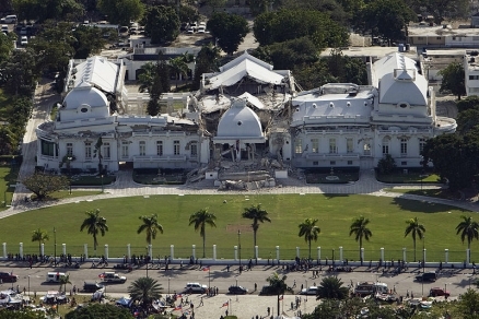
Damaged Haitian national palace, Port-au-Prince. Source: UN
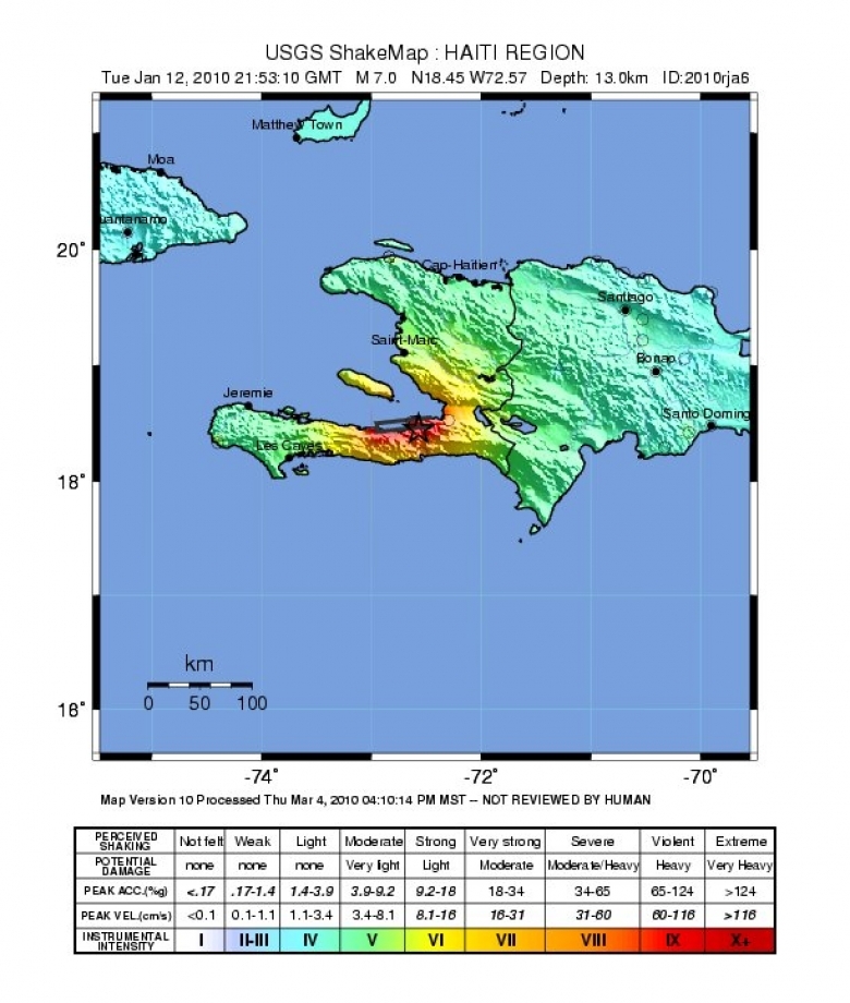
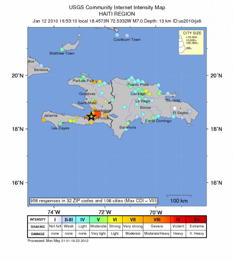
On January 12, 2010 at 4:53 p.m. local time, Haiti experienced a major earthquake of magnitude 7.0 on the Richter Scale, centered 10 miles (15 km) southwest of the capitol city of Port-au-Prince at a depth of 13 km (8.1 miles). (18.457°N, 72.533°W)
While the country experiences earthquakes frequently, this was the largest earthquake experienced by the island in over a century and occurred near a heavily populated area with few buildings designed or built to withstand significant earthquakes. The US Geological Survey (USGS) estimated that nearly three million people were exposed to severe shaking. Because the earthquake occurred inland, there was no related tsunami, however landslides related to the earthquake are expected.
According to official estimates by the Haitian government::
- 316,000 people were killed,
- 300,000 injured,
- 1.3 million displaced,
- 97,294 houses destroyed and 188,383 damaged in the Port-au-Prince area and in much of southern Haiti.
Other estimates suggest substantially lower numbers of casualties, perhaps as low as fewer than 100,000. The casualties include at least 4 people killed by a local tsunami in the Petit Paradis area near Leogane.
The United Nations Office for Coordination of Humanitarian Affairs estimated the fatalities at 222,570.
Contents
Background
Haiti occupies the western part of the Caribbean island of Hispaniola, one of the Greater Antilles islands, situated between Puerto Rico and Cuba. The eastern two-thirds of Hispaniola is occupied by the Dominican Republic. Much of the island of Hispaniola sits on the Gonave microplate, a small strip of the earth’s crust in the boundary region between two major tectonic plates - the Caribbean plate and the North America plate. The Caribbean plate is moving eastward with respect to the North America plate.
Two major east-west trending, "strike-slip fault systems" cross the island as shown in Figure 2. -- the Septentrional fault system to the north and the Enriquillo-Plaintain Garden fault system (EPGFZ) to the south. This earthquake occurred in the Enriquillo-Plaintain Garden fault system.
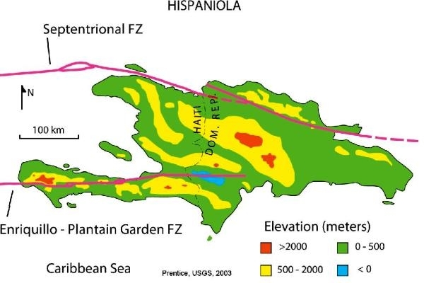
The Enriquillo-Plaintain Garden fault system is so named because it extends from the Enriquillo Valley of the Dominican Republic the east to the region of the Plantain Garden River in Jamaica to the west.The fault crosses the southern peninsula of Haiti, crosses the Jamaica Passage between the islands of Jamaica and Hispaniola and along the southern edge of the Blue Mountains of eastern Jamaica.
The Enriquillo-Plaintain Garden fault system marks the southern edge of the Gonave microplate. This fault system accommodates movement of about 7 mm/year, nearly half the overall motion between the Caribbean plate and North America plate.
The Enriquillo-Plaintain Garden fault system has not produced a major earthquake in recent decades. The EPGFZ is the likely source of historical large earthquakes in 1860, 1770, 1761, 1751, 1684, 1673, and 1618, though none of these has been confirmed in the field as associated with this fault.
According to French historian Moreau de Saint-Méry (1750–1819), "only one masonry building had not collapsed" in Port-au-Prince following an earthquake on 18 October 1751, while "the whole city collapsed" during the earthquake of 3 June 1770. Another earthquake destroyed the city of Cap-Haïtien and other towns in the north of Haiti and the Dominican Republic on 7 May 1842; this earthquake also destroyed the Sans-Souci Palace.[11] In 1946, a magnitude-8.0 earthquake struck the Dominican Republic and also shook Haiti, producing a tsunami that killed 1,790 people and injured many others.[12]
In 2008, a group led by Paul Mann of the University of Texas, noted the risk of a 7.2 earthquake if the strain built up in the fault were released in a single event. They reported:
The linearity of the fault and its association with en echelon folds, pull-apart basins, and restraining bends indicates that motion is left-lateral and late Quaternary in age. Historical earthquakes indicate that the last major ruptures of the fault occurred in an east to west time-space progression that began in 1751 in south-central Hispaniola and perhaps culminated in the Kingston, Jamaica , event in 1907. Recorded seismicity over the past 40 years is sparse as expected from a fully locked fault plane. GPS-constrained block models with elastic strain accumulation give ~8 mm/year of slip rate on the fault. Since the last major event in south-central Dominican Republic was in 1751, that yields ~2 meters of accumulated strain deficit, or a Mw=7.2 earthquake if all is released in a single event today. The two largest cities within 30 km of the fault zone are Port-au-Prince, Haiti , and Kingston, Jamaica , with a combined population of 3.65 million inhabitants. We present initial results from a paleoseismic study of the Jamaica segment of the EGPGFZ conducted in January, 2008, to determine the chronology of its historic and prehistoric ruptures. Such studies should be considered high priority in Jamaica, Haiti and the Dominican Republic given the seismic hazards posed by the fault.
Felt Reports
 Figure 3. Source time function, describing the rate of moment release with time after earthquake origin. Source: Gavin Hayes, National Earthquake Information Center (NEIC), US Geological Survey
 According to official estimates, 316,000 people killed, 300,000 injured, 1.3 million displaced, 97,294 houses destroyed and 188,383 damaged in the Port-au-Prince area and in much of southern Haiti. Other estimates suggest substantially lower numbers of casualties, perhaps as low as fewer than 100,000. The casualties include at least 4 people killed by a local tsunami in the Petit Paradis area near Leogane.
Tsunami waves were also reported at Jacmel, Les Cayes, Petit Goave, Leogane, Luly and Anse a Galets. The tsunami had recorded wave heights (peak-to-trough) of 12 cm at Santo Domingo, Dominican Republic and 2 cm at Christiansted, US Virgin Islands.
Uplift was observed along the coast from Leogane to L'Acul and subsidence was observed along the coast from Grand Trou to Port Royal.
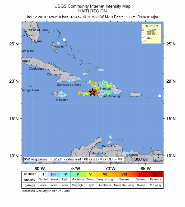
Felt:
- (VIII - Severe) at Leogane, 29km (18mi) west of Port-au-Prince.;
- (VII - Very Strong) at Carrefour, Port-au-Prince and Petionville;
- (VI - Strong) at Vieux Bourg d'Aquin;
- (V - Moderate) at Port-de-Paix, La Vega, Moca and San Cristobal;
- (IV - Light) at Bani, Bonao, Luperon, Nagua, Puerto Plata, Santiago, Santo Domingo and Sosua, Dominican Republic, and at Santiago de Cuba
- (III -Weak) at Oranjestad, Aruba; at Guantanamo, Cuba; at Cockburn Harbour, Turks and Caicos Islands; and at Maracaibo, Venezuela
- (II) - Weak) in the Kingston-Mona area, Jamaica;at Carolina and San Juan, Puerto Rico; at Cockburn Town, Turks and Caicos Islands; and at Caracas, Venezuela.
- Felt in parts of The Bahamas, Puerto Rico and the US Virgin Islands and as far as southern Florida, northern Colombia and northwestern Venezuela.
Tectonic Summary
The January 12, 2010, Haiti earthquake occurred in the boundary region separating the Caribbean plate and the North America plate. This plate boundary is dominated by left-lateral strike slip motion and compression, and accommodates about 20 mm/y slip, with the Caribbean plate moving eastward with respect to the North America plate.
Haiti occupies the western part of the island of Hispaniola, one of the Greater Antilles islands, situated between Puerto Rico and Cuba. At the longitude of the January 12 earthquake, motion between the Caribbean and North American plates is partitioned between two major east-west trending, strike-slip fault systems -- the Septentrional fault system in northern Haiti and the Enriquillo-Plantain Garden fault system in southern Haiti.
The location and focal mechanism of the earthquake are consistent with the event having occurred as a combination of reverse and left-lateral strike slip faulting on the Enriquillo-Plantain Garden fault system. The overall Enriquillo-Plantain Garden fault system accommodates about 7 mm/y of motion, nearly half the total oblique convergence between the Caribbean and North America plates. The January 12 main shock did not produce observable surface displacement on the geomorphologically well-expressed main-strand of the Enriquillo-Plantain Garden fault system, but appears instead to have primarily involved rupture of a fault or faults distinct from the previously mapped principal strand, causing significant uplift of the Léogâne delta.
The Enriquillo-Plantain Garden fault system has not produced a major earthquake in recent decades. The EPGFZ is the likely source of historical large earthquakes in 1860, 1770, and 1751, though none of these has been confirmed in the field as associated with this fault.
Sequence of events possibly associated with the Enriquillo fault in 1751-1860 are as follows.
October 18, 1751: a major earthquake caused heavy destruction in the gulf of Azua (the eastern end of the Enriquillo Fault) which also generated a tsunami. It is unclear if the rupture occurred on the Muertos thrust belt or on the eastern end of Enriquillo Fault.
Nov. 21, 1751: a major earthquake destroyed Port-au-Prince but was centered to the east of the city on the Plaine du Cul-de-Sac.
June 3, 1770: a major earthquake destroyed Port-au-Prince again and appeared to be centered west of the city. As a result of the 1751 and 1770 earthquakes and minor ones in between, the authorities required building with wood and forbade building with masonry.
April 8, 1860: there was a major earthquake farther west accompanied by a tsunami.
"Haiti Mission Report"
In a "Haiti Mission Report" by the United Nations Environment Programme released two months after the eathquake, the impacts was sumarrized as follows:
According to official United Nations (UN) estimates, the earthquake killed 222,570 people, injured an estimated 300,000 and left 1,000,000 homeless, making it comparable, in terms of human tragedy, to the South-East Asian tsunami of 2004 (which caused 230,000 deaths spread across fourteen countries). This catastrophic event was also characterized by severe damage to the capital city, where the majority of casualties were incurred, and by the enormity of its impact on humanitarian response mechanisms, due to the destruction of all lifeline buildings (ranging from the presidential palace to schools and hospitals).
In addition to the severe damage in Port-au-Prince, several cities and villages in the south of the island were impacted, resulting in extensive death and destruction. The Government has estimated that some 250,000 residences and 30,000 commercial buildings collapsed or were badly damaged. The earthquake has thus led to significant population displacement, with many people, including some whose homes were not damaged, vacating the city and moving out into the open. The United Nations estimates that up to 1.9 million people are in need of food aid for the foreseeable future.
and,
. . . all the fatalities in this case occurred within 100 kilometers of Port-au-Prince in an area covering only about 25 percent of the total geographical area of Haiti. The earthquake killed 222,570 people – one in every 45 Haitians – which is perhaps one the largest such ratios in history (major tragedies have typically occurred in more populated places). In addition, it devastated the capital city, demolished the presidential palace (along with numerous other ministries and Government buildings), destroyed the office of the United Nations (killing 92 UN staff including the Head of the Mission), and killed the leader of the opposition party and the capital’s archbishop.
Images
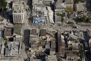 Port-au-Prince, the downtown core shows the damage after the earthquake. Source: United Nations Development Programme Port-au-Prince, the downtown core shows the damage after the earthquake. Source: United Nations Development Programme |
 Port-au-Prince, the Haitian national palace shows heavy damage after earthquake. Source: United Nations Development Programme Port-au-Prince, the Haitian national palace shows heavy damage after earthquake. Source: United Nations Development Programme |
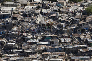 Port-au-Prince, a poor neighbourhood shows the damage after earthquake. Source: United Nations Development Programme Port-au-Prince, a poor neighbourhood shows the damage after earthquake. Source: United Nations Development Programme |
 A Haitian boy receives treatment at an ad hoc medical clinic following the earthquake. Source: United Nations Development Programme A Haitian boy receives treatment at an ad hoc medical clinic following the earthquake. Source: United Nations Development Programme |
Further Reading
- Magnitude 7.0 - HAITI REGION US Geological Survey (accessed January 16, 2010)
- [[class="printonly">http://www.ig.utexas.edu/jsg/18_cgg/Mann3.htm class="reference-accessdate">. class="citation web">"Entiquillo-Plantain Garden Strike-Slip Fault Zone: A Major Seismic Hazard Affecting Dominican Republic, Haiti and Jamaica"]], Mann, Paul, Calais, Eric, Demets, Chuck, Prentice, Carol S., and Wiggins-Grandison, Margaret (March 2008). 18th Caribbean Geological Conference. Retrieved 2010-01-13.