Turks and Caicos Islands
| Topics: |
This content is not assigned to a topic
|

Location of Turks and Caicos Islands. Source: Raimond Spekking/Wikipedia
Countries and Regions of the World Collection  The Turks and Caicos Islands are a British Overseas Territory consisting of two groups of tropical islands in the West Indies, the larger Caicos Islands and the smaller Turks Islands, known for tourism and as an offshore financial centre. Approximately fourty six thousand people live on the Turks and Caicos.
The Turks and Caicos Islands are situated about 600miles (970km) southeast of Miami in the United States, and 50miles (80km) southeast of Mayaguana in the Bahamas, and have a total land area of 166square miles (430km2).
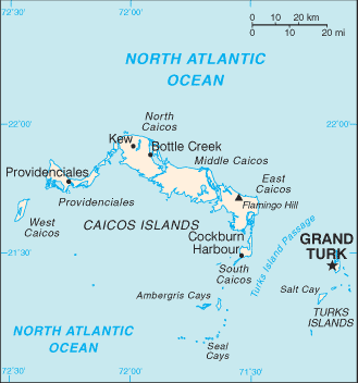 Map of Turks and Caicos Islands (Source: CIA, The World Factbook)
The islands are geographically contiguous to the Bahamas, but are politically a separate entity.
The islands were part of the UK's Jamaican colony until 1962, when they assumed the status of a separate crown colony upon Jamaica's independence. The governor of The Bahamas oversaw affairs from 1965 to 1973. With Bahamian independence, the islands received a separate governor in 1973. Although independence was agreed upon for 1982, the policy was reversed and the islands remain a British overseas territory.
Its major environmental issues include: limited natural fresh water resources, private cisterns collect rainwater.
Geography
Location: Caribbean, two island groups in the North Atlantic Ocean, southeast of The Bahamas, north of Haiti.
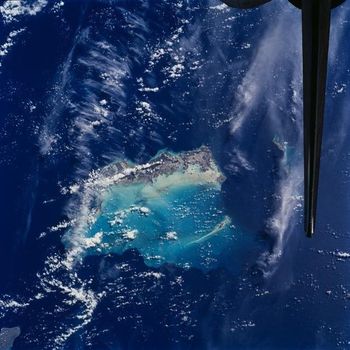 The Turks and Caicos Islands as seen from the space shuttle. In this view, the extensive shallow water areas of Caicos Bank (turquoise) dominate to the south of the Caicos Islands. Caicos Bank covers an area of 7,680 sq km (2,965 sq mi). The coral reefs of Caicos are primarily along the north deep water edge of the islands, and in a barrier to the south of the bank. East of Caicos Bank, near the tail of the shuttle, is the island of Grand Turk, part of the much smaller Turks Bank. The channel that runs between the two banks is more than 2,200 m (1.4 mi) deep. Source: NASA.
 Geographic Coordinates:21 45 N, 71 35 W
Area: total: 430 sq km
arable land: 2.33%
permanent crops: 0%
other: 97.67% (2005)
Coastline:389 km
Maritime Claims: Territorial sea to 12 nautical miles and an Exclusive fishing zone to 200 nautical miles.
Natural Hazards: Frequent hurricanes
Terrain: Low, flat limestone; extensive marshes and mangrove swamps. The highest point is Blue Hills (49 meters)
Climate: Tropical; marine; moderated by trade winds; sunny and relatively dry
Capital:Grand Turk (Cockburn Town) - 6,000 (2009)
Ecology and Biodiversity
The Bahamian dry forests ecoregion is distributed over a wide geographic area among the Bahamas and Turks-Caicos archipelago. These dry tropical forests support a large fraction of the human population in the Caribbean Sea area putting them under intense pressure from deforestation and intensive agricultural use. Considerable progress has been made in the designation of protected areas and reserves within this ecoregion, however, forestry practices still are not well developed. Of the endemic plants and animals found in these dry forests, perhaps the most notable are the five species of West Indian Rock Iguana (Cyclura sp.). All flora and fauna however suffer from the same problems (i.e., population-related development, agricultural encroachment, hunting, introduced species, and limited enforcement of wildlife and environmental legislation) that must be addressed in any long-term conservation strategies.
The Bahamian mangroves ecoregion is found in a large area of shallow water that is of high importance for its ecological productivity. The mangroves are an important source of nutrients and provide shelter for many juvenile species of fish associated with this area, which also includes extensive coral reefs and seagrass beds. They also contain areas of high importance for large populations of resident and migratory waterfowl as well as many other species of avifauna.
Biological diversity in the Caribbean Islands
See: Common coral reef fishes of West Caicos;
People and Society
Population: 46,335 (July 2012 est.)
Ethnic groups: black 87.6%, white 7.9%, mixed 2.5%, East Indian 1.3%, other 0.7% (2001 census)
Age Structure:
0-14 years: 22.7% (male 5,188/female 5,008)
15-64 years: 73.2% (male 16,653/female 16,156)
65 years and over: 4% (male 813/female 1,001) (2011 est.)
Population Growth Rate: 3.17% (2012 est.)
Birthrate: 17.44 births/1,000 population (2012 est.)
Death Rate: 3 deaths/1,000 population (July 2012 est.)
Net Migration Rate: 17.27 migrant(s)/1,000 population (2012 est.)
Life Expectancy at Birth: 79.26 years
male: 76.53 years
female: 82.12 years (2012 est.)
Total Fertility Rate: 1.7 children born/woman (2012 est.)
Languages:English (official)
Literacy: 98% (1970 est.)
Urbanization: 93% of total population (2010) growing at a 1.6% annual rate of change (2010-15 est.)
Economy
The Turks and Caicos economy is based on tourism, offshore financial services, and fishing. Most capital goods and food for domestic consumption are imported. The US is the leading source of tourists, accounting for more than three-quarters of the 175,000 visitors that arrived in 2004. Major sources of government revenue also include fees from offshore financial activities and customs receipts.
GDP: (Purchasing Power Parity):$216 million (2002 est.)
GDP- per capita (PPP):$11,500 (2002 est.)
GDP - Composition by sectors:
agriculture: 1% (corn, beans, cassava (tapioca), citrus fruits; fish)
industry: 24.4%
services: 74.6% (2011 est.)
Industries: tourism, offshore financial services
Natural Resources:spiny lobster, conch
Currency: the US dollar is used