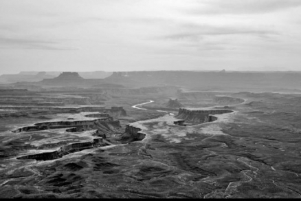
Green River (Utah)
| Topics: |
Geology (main)
|
The Green River drains portions of southwest Wyoming, northwest Colorado and northeast Utah, prior to discharging to the Colorado River in the USA.
 Map of the Green River Basin. Source: K.Musser/USGS The Green River rises in the Wind River Mountains of southwestern Wyoming. On the border between Wyoming and Utah, the Green River passes through the 207,363 acre Flaming Gorge National Recreation Area which includes the 91 mile (146 km) long Flaming Gorge Reservoir, behind the theFlaming Gorge Dam. Farther south the river arcs east into Colorado where it is joined by the Yampa River. The 210,278 acre Dinosaur National Monument covers this area. The 337,570 acre Canyonlands National Park is at the confluence of the Green River and the Colorado River.
There are a number of endangered fish species in the Green River, which are threatened by the Flaming Gorge hydroelectric project, which has reduced the rapid flowing habitat of the Green River.
The Green River Basin is one of the most notable locales in North America for faunal fossil recovery of extinct species.
The Green River Basin holds some of the largest and most significant oil shale deposits in North America. The basin along with the enitre Colorado River Basin is the exemplar formation of river cut sandstone from rapid mountain river flowing waters in the USA.
While the Grand Canyon of the Colorado River boasts the highest visitation, the Green River exhibits equally spectacular, even if less deep, sinuous gorge formations.
Contents
Hydrology
The course of the Green River extends 1175 kilometers, beginning with its headwaters in the Wind River Mountains of southwestern Wyoming. The Green River is the chief tributary of the Colorado River, with the confluence occurring in eastern Utah. Mean discharge near the confluence is approximately 173 cubic meters per second.
Water quality
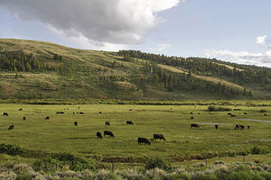 Grazing in the South Piney Creek watershed, a sub-shed of the Green. @ U.S. Department of Agriculture According to tests by the U.S. Government, the mean concentration of total dissolved solids in agricultural reaches of the Green River in Utah is about 360 milligrams per liter (mg/l); however, samples collected from seeps and drains where water was returned to the Green River during low-flow conditions was approximately 4170 mg/l. Dissolved-solids levels from the shallow part of the groundwater basin ranged widely from about 690 to 55,900 mg/l.
Discernible concentrations of total dissolved solids discharging to the Green River are present almost exclusively along the river banks or near the mouths of dry washes that drain agricultural areas. The median total dissolved solids load in discharge from agricultural drains and seeps 20 kilograms per drain per day. Seasonal estimates of the dissolved-solids load ranged from 140 tons per drain in the winter to 380 tons per drain in the spring.
The USGS also assessed water samples collected from within the Green River agricultural areas for naturally occurring isotopes of strontium and boron, which isotopes can be useful for differentiating dissolved-solids sources. Substantial variations in the delta strontium-87 and delta boron-11 values among the sites were measured. Canal and river samples had relatively low concentrations of strontium and the heavier isotopic ratios, while drains and seeps had a wide range of strontium concentrations and isotopic ratios that generally were lighter.
Nitrate levels in the Green River typically amount to approximately two to five milligrams per liter, and are chiefly attributed to agricultural runoff from grazing of livestock and from additions of chemical fertilizers to cropping areas.
Aquatic biota
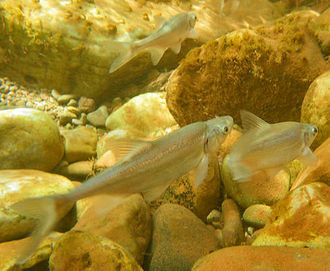 Juvenile Gila cypha in the wild. Source: Melissa Trammell, U.S.National Park Service There are a number of significant fishes in the Green River, including the endangered humpback sucker (Gila cypha), a large minnow specialized to rapid current and wide temperature swings. Two of the known six populations of the humpback sucker are found in the Green River: Desolation and Gray canyons, Utah; and in Dinosaur National Monument, Colorado and Utah.
The bonytail chub (Gila elegans) is another endangered minnow found in limited stretches of the Green and Colorado Rivers.
The Vulnerable Colorado pikeminnow (Ptychocheilus lucius), the largest cyprinid fish in North America, is found in only a few drainages of the upper Colorado Basin, including the Green River, Gunnison River, White River, San Juan River and Yampa River.
The Vulnerable flannelmouth sucker (Catostomus latipinnis) is also found in the Green River, along with parts of the larger Colorado River Basin All four of these fish species have been threatened by the Flaming Gorge hydroelectric dam as well as the Glen Canyon downriver on the Colorado River.
Terrestrial ecoregions
The following ecoregions lie within the drainage basin of the Green River:
The South Central Rockies forests prevail in most of the headwaters area on the Colorado Plateau in southwestern Wyoming. The dominant vegetation regime in this ecoregion is coniferous forest, with chief plant association type of Douglas-fir / spruce-fir forest, which is dominated by Engleman spruce (Picea englemannii), subalpine fir (Abies lasiocarpa), and Douglas-fir (Psuedotsuga menziesii).
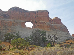 Scrub habitat at the Arches National Park. @ C.Michael Hogan TheColorado Plateau shrublands is a cold desert ecoregion that occupies the lower reaches of the Green River. This desolate landscape boasts a number of endemic vertebrate species including: Kaibab squirrel (Sciurus aberti kaibabensis); banner-tailed kangaroo rat, Bailey’s race (Dipodomys spectabilis baileyi); desert night lizard, Utah race (Xantusia vigilis utahensis); and Gunnison sage grouse (Centrocercus sp.) In spite of the fact that this landscape appears largely intact, a number of vertebrate species have been extirpated from the Colorado Plateau shrublands, even though they remain extant, but threatened in their surviving range; chief among these vertebrate extirpations are: grizzly bear (Ursus arctos), gray wolf (Canis lupus), black-footed ferret (Mustela nigripes), lynx (Lynx lynx), wolverine (Gulo gulo), bison (Bison bison) and river otter (Lontra canadensis).
However, some large mammals that previously inhabited this ecoregion were driven totally extinct on Earth during the ascent of prehistoric man; these extinctions include: the Columbian mammoth (Mammuthus columbi) and Shasta ground sloth (Nothrotheriops shastensis).
This ecoregion supports over 300 endemic plants, examples of which include: Jones cycladenia (Cycladenia humilis var. jonesii), Kachina daisy (Erigeron kachinensis), Shultz stickleaf (Mentzelia shultziorum), Jane’s globemallow (Sphaeralcea janeae) and Welsh’s milkweed (Asclepias welshii).
Natural history
The Green River Basin is one of the richest areas in the USA for Fossil recovery, including skeletons of dinosaurs,Columbian mammoth and numerous fishes such as those of the genus Knightia. In addition to the abundance of Knightia in the Eocene, many other predators of Knightia have been recovered in fossil form, including specimens of Diplomystus, Lepisosteus, Amphiplaga, Mioplosus, Phareodus, Amia, and Astephus, all of which have all been recovered in fossil form with Knightia in either the jaws or digestive tract.
The first giant ant fossil discovered in the Western Hemisphere was found at the Farson Fossil Fish Beds in the Green River Basin; Titanomyrma lubei, an ant the size of a hummingbird was dated to 49.5 million years before present. Other key paleontological loci in the Green River Basin are the Eighteenmile Canyon Fish Beds, and Canyon Creek Fossil Rookery sites.
Prehistory
The earliest and best preserved burial site and human habitations are found in the headwaters area in Sublette County, Wyoming. This area is known as the Finley site and dates to the Archaic Period of Native American prehistory in this region. The site locus is also within the Jonah Field of energy exploration.
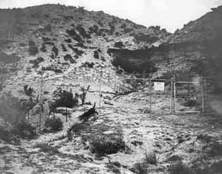 Wardell Buffalo Trap box canyon. Source: Wyoming State Historic Preservation Office In the late Prehistoric Period the Green River Basin occupied an important part of western Native American cultural development. This locus served as the center of the westward expanding Plains bison hunting during the era from 500 to 1500 AD; at that time the Plains bison hunting culture was expanding into Idaho and Oregon. During the latter part of this era, the notable bison killing site known as the Wardell Buffalo Trap was used intensively; this box canyon near Big Piney, Wyoming was excavated by archaeologists to find a staggering 17 meter deep layer of bison bones. Projectile points found here are of the Avonlea type, and ceramics can be traced to the Athabaskan culture.
The Shoshone entered the Green River Basin circa 1500 AD.
Notable archaeological sites in the Green River Basin are:
- Sage Creek Mountain burial sites;
- LaClede stage station;
- White Mountain petroglyphs;
- Cedar Canyon petroglyphs;
- Tolar petroglyphs;
- LaBarge Bluffs petroglyphs;
- Pine Spring;
- North Table Mountain stratified site; and,
- Eden-Farson site.
History
The Green River Basin did not enter recorded history until the fourth quarter of the eighteenth century. Fathers Francisco Atanasio Dominguez and Silvestre Velez de Escalante led an expedition into the Green River Basin in 1776, although a lesser known exploration led by Rivera occurred at a relatively similar timeframe, but the latter yielded much less recorded information. The Escalante/Dominguez expedition chose a route to avoid contact with the notarious Chirumas tribe, reputed aggressive cannibals.
Arriving from the south, Escalante and Dominguez crossed the Green River and followed the Duchesne and Strawberry Rivers upstream. Moving from the Uinta Basin into the catchment of Diamond Fork, the party descended to the Spanish Fork River.
References
- S.J.Gerner, L.E.Spangler, B.A.Kimball, D.E.Wilberg, and D.L.Naftz. 2006. Scientific Investigations Report 2006-5186 Hydrology and Water Quality in the Green River and Surrounding Agricultural Areas near Green River in Emery and Grand Counties, Utah, 2004-05. U.S.Geological Survey. Government Printing Office, Washington DC
- James D. Keyser & George Poetschat. 2005. Warrior art of Wyoming's Green River Basin: biographic petroglyphs. books.google.com Oregon Archaeological Society. 190 pages
- Frank W.Osterwald & William Harold Wilson. 1966. Mineral resources of Wyoming. books.google.com 287 pages
- Katieri Treimer, C.Michael Hogan, Marc Papineau, et al. 1989. Site research report, site no. 916, Southwest Colorado. Earth Metrics Inc. and SRI International for Contel Systems and the U.S. Air Force. Published by the Government Printing Office
- D.E.Wilberg, J.R.Tibbetts, Michael Enright, C.B.Burden, Cynthia Smith, and C.E.Angeroth. 2006. Water-resources data for the 2005 water year for Utah. U.S.Geological Survey, Washington DC
