Glacier Bay National Park and Preserve, United States
| Topics: |
Contents
- 1 Geographical Location
- 2 Date and History of Establishment
- 3 Area
- 4 Land Tenure
- 5 Altitude
- 6 Physical Features
- 7 Climate
- 8 Vegetation
- 9 Fauna
- 10 Cultural Heritage
- 11 Local Human Population
- 12 Visitors and Visitor Facilities
- 13 Scientific Research and Facilities
- 14 Conservation Value
- 15 Conservation Management
- 16 IUCN Management Category
- 17 Further Reading
Geographical Location
Glacier Bay National Park (58°10'-59°15'N, 135°15'-138°40'W_ and adjacent Preserve to the north-west are a World Heritage Site located in the northern part of south-east Alaska which lies at the north-western end of the Alexander Archipelago. The center of the park is approximately 144 kilometers (km) north-west of Juneau, and about 965 km south-east of Anchorage. It is bounded by the Gulf of Alaska to the west, Cross Sound and Icy Strait to the south, the Chilkat Range and Canada to the east, and the St. Elias Mountains, Alsek River and Tongass National Forest to the north/
Date and History of Establishment
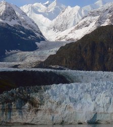 Glacier Bay National Park and Preserve. (Source: U.S. National Park Service)
 Glacier Bay National Monument was created by Presidential Proclamation in 1925 under the authority of the Antiquities Act, 1906. The monument was expanded by proclamation in 1939 and again in 1978 to 1.13 million hectares (ha). By virtue of the Alaska National Interest Lands Conservation Act, 1980, Glacier Bay National Preserve was created in the vicinity of the Alsek River, and Glacier Bay National Monument was enlarged and re-designated as Glacier Bay National Park. Prior to 1980, the area of the preserve was managed by the US Forest Service as part of Tongass National Forest. About 85% of the national park has been designated a wilderness area under the Wilderness Act, 1964, with other areas currently being considered. Glacier Bay, together with the nearby Admiralty Island National Monument, was internationally recognized as a Biosphere Reserve under UNESCO's Man and the Biopshere Programme in 1986. Glacier Bay National Park and Preserve were inscribed on the the World Heritage List in 1992, as part of the existing Canadian/USA transfrontier World Heritage Site of Kluane National Park/Wrangell-St. Elias National Park and Reserve.
Area
Glacier Bay National Park (1,312,424 ha) and Preserve (23,068 ha) cover 1,335,492 ha, comprising 252,000 ha of saltwater and 1,415 km of coastline. Glacier Bay-Admiralty Island Biosphere Reserve has a total area of 1,714,851 ha. Glacier Bay is contiguous to Endicott River Wilderness (Tongass National Forest) (40,540ha) and Tongass National Forest (6,708,900 ha) in the United States.
Land Tenure
Glacier Bay National Park and Preserve are owned by the federal government, except for about 80 ha of Brady Ice Field (west of Glacier Bay) which are patented mining claims, two private tracts of land of about 80 ha on the shoreline near Gustavus, and 4,000 ha of tentative native allotment claims which 10 people have identified for subsistence uses under the Alaska Native Claims Settlement Act, 1972.
Altitude
Ranges from 500 meters (m) below sea level to 4,670 m.
Physical Features
The area, which contains numerous landscapes (Landform development) and ecosystems, is a superlative example of the ice-affected landscapes typical of the central segment of the Sitkan Province. High mountain ranges, coastal beaches with protected coves, deep fjords, tidewater glaciers, coastal and estuarine waters, and freshwater lakes are characteristic of the region.
Glacier Bay, a large fjord of 105 km in length, has experienced four major advances and retreats of glaciers in recent geological time. Two centuries ago, the Bay was completely filled with Grand Pacific Glacier and has witnessed an unprecedented rate of glacial retreat of about 95 km in the past 200 years. As the main glacier has retreated, 20 separate glaciers, many of them tidewater glaciers, have been created.
The landscape falls into three broad categories: land covered by snow, ice or bare rock (35%); successional vegetation (30%); and more mature vegetation (35%). There are parts of four mountain ranges, running in a north-south direction within park boundaries: the Fairweather Range to the west, culminating in Mount Fairweather at 4,670 m; the tip of the St. Elias Range to the north; the Takhinsha Range to the north-east; and the Chilkat Range to the east. The Alsek River, which joins with Canada's Tatshenshini River, is one of very few river systems to breach the coastal range from the subarctic interior, and the Alsek River delta represents the confluence of several streams and rivers in the park. Marine areas include an inshore portion of the continental shelf, fjord systems of various depths and isolated saltwater bodies or 'salt chucks'.
One major and several lesser faults run through the park and preserve and earthquakes are noted to occur regularly. The bedrock geology is complex with a wide variety of depositional, intrusive and tectonic events ranging in age from early Palaeozoic to Tertiary. The park includes six geological provinces, which are, from south-west to north-east: Lituya, Fairweather, Tarr Inlet, Geikie, Chilkat, and Muir. A total of 17 areas has been identified as either containing important mineral deposits or being favorable for their occurrence.
Climate
Conditions are maritime with cool, wet summers and mild, wet winters. At higher altitudes, severe arctic conditions prevail. Annual precipitation is approximately 1,800 millimeters (mm), with precipitation being greatest on the coast at 2,870 mm and 1,390 mm inland. Temperatures range from a January mean high of -2°C and a mean low of -7°C to a July mean high of 17°C and a mean low of 8°C. Prevailing winds are east-south-east with an average annual wind speed of 8-10 knots.
Vegetation
There are four terrestrial habitats in and around the properties: wet tundra; coastal western hemlock Tsuga heterophylla/sitka spruce forest Picea sitchensis; alpine tundra; and glaciers and icefields. Surface material deposits from glaciers and icefields form moraines which are colonized by lichens and mosses, horsetail Equisetum sp., willows Salix spp., fire weed Epilobium sp., and mountain avens Dryas drummondii. These are followed by alder Alnus spp., willow, soapberry Sapindus drummondi and cottonwoodPopulus balsamifera var. trichocarpa. More mature forest associations of western hemlock and sitka spruce occur in areas further away. Wet tundra, present near Gustavus, has a ground cover of sedges Cyperaceae and cottongrass Eriophorum sp., with lodgepole pine Pinus contorta, shrubby willow Salix sp. and sitka alder Alnus sp. Coastal western hemlock and sitka spruce occur along the western and southern edges of the park, mixed with black cottonwood Populus sp. and sitka alder along streams and beach fringes, and an understorey of moss, blueberry Vaccinium sp. devil's-club Oplopanax horridus, skunk cabbage and ferns. Alpine tundra occurs above 760 m and consists of barren [[rock]s] and rubble interspersed with woody herbaceous and shrubby plant communities. Willows and dwarf blueberry are found in this habitat.
Aquatic habitats include freshwater (Freshwater biomes) (lakes, rivers, streams, muskets, and freshwater marshes) and marine (intertidal and neritic zones, estuaries, fjords and upper inlets). Characteristic marine algae are Laminaria spp. Alaria spp., Ulva spp., Porphyron spp., Fucus districhus and Nereocystis spp.
Fauna
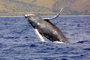 North Pacific humpback whale. (Source: NOAA)
 Twenty-eight terrestrial mammals are found in the park and preserve, including grey wolf Canis lupus (V), brown bear Ursus arctos, black bear U. americanus, wolverine Gulo luscus, river otter Lutra canadensis, Canadian lynx Lynx canadensis, black-tailed deer Odocoileus hemionus, moose Alces alces and mountain goat Oreamnos americanus. Unique to Glacier Bay is the Glacier Bay water shrew Sorex alaskanus, which is being considered for listing as threatened or endangered under the US Endangered Species Act, 1973. There are eight marine mammals including harbour seal Phoca vitulina, Stellar sea lion Eumetopias jubata, and humpback whale Megaptera novaeangliae. An unsuccessful attempt was made to reintroduce sea otter Enhydra lutris in 1968. The only endangered species known to occur in the area are humpback whale and peregrine falcon Falco peregrinis.
Of the 210 recorded bird species only 14 sea and 23 land birds can be considered common, including bald eagle Haliaeetus leucocephalus. Other species include marbled murrelet Brachyramphus marmoratus, trumpeter swan Cygnus buccinator, and golden eagle Aquila chrysaetos. At least 65 species of seabirds migrate or breed along the outer coast of Glacier Bay National Park and Preserve, and adjacent waterways.
Over 237 fish species occur, including all five species of Alaskan pacific salmon: chum Oncorhynchus keta, red O. nerka, silver O. kisutch, pink O. gorbuscha, and king O. tshawytscha. Marine fish are diverse and include Pacific halibut Hippoglossus stenolepis, Pacific herring Clupea pallasii, Pacific cod Gadus macrocephalus, capelin Mallotus villosus and Pacific sandlance Ammodytes hexapterus. Pacific halibut and various rockfish Sebastes spp. and Sebastolobus spp. comprise the finfish harvest, while the shellfish harvest comprises red king crab Paralithodes camtschatica, Dungeness crab Cancer magister, blue king crab Paralithodes platypus, brown king crab Lithodes aequispina, and tanner crab Chionoecetes biardi. The freshwater (Freshwater biomes) fish fauna is more limited and includes dolly varden Salvelinus malma, cut-throat trout Salmo clarki and three-spined stickleback Gasterosteus aculeatus.
Cultural Heritage
The earliest evidence of occupation in the area dates back to about 10,000 years BP. In the 18th and 19th century the territory was occupied by the Tlingits whose main settlements were in the vicinity of Excursion Inlet/Point Couverden; Point Frederick, where the present village of Hoonah is located; Listi Village by Dundas River; and Dry Bay which had a permanent Tlingit village, indicating the importance of the Alsek River in regional history. The Tlingits also had seasonal food gathering camps, 21 of which have been identified in the park and preserve. Following the Tlingits, sporadic settlements arose in connection with European mining, fur-trading, logging, commercial fishing and pioneering. The damp climate and rapidly growing vegetation of the region have, however, obliterated most of these settlements.
The area is of historic interest, having been visited by navigators, explorers and fur-traders such as Chirikoff (1741), Cook (1778), Vancouver (1794) and Muir in 1879. Two historic structure complexes are currently on the park's List of Classified Structures: Harbeson cabin and woodshed (1930s and 1940s) on the east shore of Dundas Bay, and Dundas Bay cannery complex (from 1898) on the west shore of Dundas Bay. Cape Spencer lighthouse is listed on the National Register of Historic Places.
Local Human Population
More than 200 people reside temporarily in Dry Bay during the summer to partake in commercial and subsistence hunting and fishing in the preserve. There is also a fish processing plant and related support facilities at Dry Bay. An administrative site at Bartlett Cove employs 13 people year-round and 135 in the summer. At present, there are no permanent Native American settlements in the park or preserve, or in the immediate vicinity. The nearest Tlingit settlement is Hoonah, 40 km south-west of Glacier Bay. The four area communities of Hoonah, Elfin Cove, Pelican, and Gustavus rely on commercial fishing in and around park waters.
Visitors and Visitor Facilities
In 1983, there were 96,000 visitors, representing a four-fold increase over a ten-year period. Presently, nearly 200,000 visitors access the park annually via cruise ships, tour boats, charter boats and small aircraft. A park interpretive program and naturalists board cruise ships and tour boats provide a variety of formal and informal services. Services and facilities in the park include a lodge, ranger station, fuel dock for boats, a camp ground (35 units) and 5 km of marked trails. Glacier Bay Lodge, with 55 cabin units, operates from mid-May to mid-September and is situated at Bartlett Cove, as is the camp ground. Access to the back country is usually by tour boat which drops off kayakers, hikers, campers and skiers. Aerial sightseeing, sport hunting and fishing activities are available. A joint US Forest Service/National Park Service visitor information station, giving detailed information about the park, is operated from the Centennial building in Juneau.
Scientific Research and Facilities
Muir was responsible for the exploration of the area in 1879, and scientific studies commenced shortly thereafter. Research into the dynamics associated with glacial retreat were begun as early as 1890 and have been studied extensively since 1926 by Dr William O. Field and a cadre of geologists, glaciologists and botanists inspired by his work. Research into terrestrial revegetation was pioneered by W.S. Cooper and D.B. Lawrence, and continuous documentation for more than 70 years has provided one of the most complete descriptions of vegetative development in the world, with the resulting insights greatly shaping plant successional theory. The humpback whale has been studied and monitored for the past 18 years.
The five main research areas are: geology, glaciology and climatology; terrestrial ecosystems; marine and aquatic ecosystems; resource management; and history and anthropology. The Glacier Bay Science Symposium, held every five years, provides a forum for scientists working in the region to exchange information on their work. The National Park Service offers logistical and communication support to research groups, subject to certain requirements, and the park hosts a large summer research effort. The park office maintains a collection of 3,500 specimens and a reference library.
Conservation Value
Glacier Bay, the area of which is mostly unmodified wilderness, is most renowned for the last two centuries of rapid glacial retreat, the formation of 16 tidewater glaciers, its display of world-class depositional features, and a broad range of stages in ecological succession stretching from pioneering mosses and lichens to mature temperate rainforests. Associated with these various stages is incumbent terrestrial wildlife. Of the 30 tidewater glaciers in the world today, 16 are found in Glacier Bay. The tidewater glaciers represent, however, only a fraction of the glaciers found in the park, many of which are retreating, while a few are still advancing. Glacial and ecological processes are observable along an elevational gradient from the top of Mount Fairweather (4,670 m) to a depth of more than 500 m, with this gradient including arctic, subarctic, and temperate terrestrial environments, along with a range of [[coast]al], estuarine and freshwater (Freshwater biomes) systems. Glacier Bay is a focal point of earth dynamics where continental plates collide, and is considered to be Alaska's highest seismic risk (Risk assessment) zone. As part of a larger complex, Glacier Bay enhances the representation of later stages of glacial and ecological succession, and includes significant marine components and their characteristic marine species.
Conservation Management
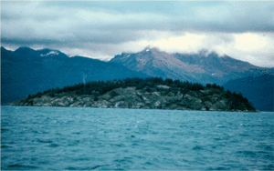 Glacier erosion has produced this streamilined bedrock mass projecting above the waters of Glacier Bay, Glacier Bay National Park, Alaska. (Source: U.S. Geological Service)
 Glacier Bay National Park and Preserve are administered by the National Park Service, Department of the Interior. The 1982 Statement for Management and the 1984 General Management Plan set the overall direction for management of natural and cultural resources, visitor use, land protection, and facility development. These plans will remain in place for about 15 years.
One of the main reasons for the establishment of Glacier Bay National Monument (1925) was the opportunity it afforded to study plant succession and animal recolonization following glacial retreat. Consistent with this, the general aims of management today are ecosystem conservation, baseline study and monitoring (Environmental monitoring and assessment), and public recreation and education. In the preserve, the proper management of ongoing consumptive uses of resources is a further objective. In accordance with the general management plan, there are five zoning categories in the park: non-wilderness waters; wilderness lands; wilderness waters; development; and special use, while the preserve has non-wilderness waters, special use, wilderness, and natural zones. North and South Marble Islands contain the largest seabird colonies in the park and fall within wildlife protection zones. These sites, along with certain other islands, are closed during nesting season, from 1 May to 1 September. A mid-channel marine corridor in Glacier Bay is designated for motorized vessels between 1 June and 31 August to protect humpback whales from disturbance while feeding in the rich waters of the park. There is currently a proposal to eliminate the harvest in marine fish and shellfish within seven years unless they prove to be compatible with the conservation of the marine ecosystem and other park values.
Glacier Bay National Park and Preserve is used primarily for non-destructive recreation and, apart from limited commercial and sport fishing activities, all resources within the park are fully protected from consumptive uses by national legislation. This area is managed to provide opportunities for solitude, primitive recreation, and scientific and educational interest. The designation of 85% of the park as a wilderness area reinforces strict protection and effectively precludes human manipulation of aesthetic values, natural resources, or natural processes. The park is unique in the US in that the legislation establishing the area gave management of the ocean waters and bottom of the Bay itself, as well as an outer coastal fringe, to the National Park Service. The preserve category provides statutory authority for regulated commercial and subsistence hunting and fishing.
On-site management and protection of Glacier Bay National Park and Preserve is the responsibility of the Park Superintendent, whose headquarters are at Bartlett Cove, with administrative and policy guidance from the National Park Service Regional Director in Anchorage, Alaska, and the National Park Service Director in Washington, DC. Collaborating agencies include the US Forest Service, US Department of Agriculture; National Marine Fisheries Service & National Oceanic and Atmospheric Administration, US Department of Commerce; Fish & Wildlife Service, US Department of the Interior; the US Man & the Biosphere Program, US Department of State; and the Canadian Parks Service. The National Park Service has been directed by Congress to "seek cooperative agreements with Canada which serve to protect the entire watershed of the Alsek River, and provide for cooperative visitor use of the river and its environs."
Management Constraints
Changes in natural conditions, increasing visitor pressures and changing land use patterns have created problems which warrant consideration in ensuring the long-term protection of the park's resources. The increase in visitors and number of vessels in Glacier Bay may have affected the numbers of humpback whale which declined sharply in 1978 and have fluctuated at lower levels ever since. Illegal commercial fishing is taking place in wilderness waters.
There is currently no subsistence use of the 4,000 ha of tentative native allotment claims, and portions may revert to federal ownership as land claims are resolved.
Increasing public and commercial interest, and economic development (Patterns of economic growth and development) in the Tatshenshini-Alsek drainage has recently increased pressure upon this area from outside. One potential threat is the development of the proposed Windy-Craggy open-pit copper mine in British Columbia. Located 24 km from the park, this project has the potential to affect water quality in the Tatshenshini/Alsek River system, riparian ecosystems and fisheries (Fisheries and aquaculture), and migratory bird populations in Canada and the United States. A thorough environmental assessment and review is currently being conducted by the Canadian federal government, and under IUCN Resolution No. 18-46, adopted at the 18th Session of its General Assembly, it was recommended that the government of British Columbia defer its decision to permit the mine to operate until completion of the assessment.
Staff
Permanent full-time staff include a superintendent, chief ranger, chief naturalist, chief of resources, and a marine research biologist. There are also about 31 seasonal employees.
Budget
About US$ 972,500 for administration, interpretation, maintenance and research budgeted for the 1982 fiscal year.
IUCN Management Category
- II (National Park)
- Biosphere Reserve
- Natural World Heritage Site - Criteria ii, iii, iv
Further Reading
- Brew, D.A. (1984). Bedrock geology and mineral resources of Glacier Bay National Park and Preserve. In: Wood, J.D. Jr, Gladziszewski, M., Worley, I.A., Vequest, G. (Eds.), A Century After Muir. The Scientific Adventure. Department of the Interior, National Park Service Science Publications Office, Atlanta, Georgia. Pp. 9-10.
- Chapman, J.F. (1982). Statement for management, Glacier Bay National Park and Preserve, Alaska. Denver Service Centre, National Park Service, US Department of the Interior. 27 pp.
- Harris, D.V., and Kiver, E.P. (1985). The geologic story of the national parks and monuments. John Wiley & Sons, New York. Pp. 95-99.
- Howe, D. (1984). Bibliography of research and exploration of Glacier Bay, Alaska, 1798 to 1983. National Park Service, Science Publications Office, Atlanta, Georgia. 33 pp. 500 references to work on glaciology, glacio-geomorphology, geology and oceanography, terrestrial ecosystems, history and anthropology, marine and aquatic ecosystems and resource management issues. This is currently being revised for publication by the US Geological Survey (USA, 1991).
- NPS (1984). General management plan. Glacier Bay National Park and Preserve/Alaska. US Department of the Interior/National Park Service. 109 pp.
- Simmerman, N.L. (1983). Alaska's parklands, the complete guide. The Mountaineers, Seattle, Washington. Pp. 149-151. ISBN: 0898860539.
- Taylor, M. (1984). A mammal checklist. Glacier Bay National Park and Preserve. Alaska Natural History Association in cooperation with the National Park Service, US Department of the Interior. 8 pp.
- USA (1991). Convention Concerning Protection of the World Cultural and Natural Heritage - World Heritage Nomination, Glacier Bay National Park and Preserve. US Department of the Interior, Office of the Secretary, Washington, DC. 19 pp.
- US-MAB (1991). Directory of biosphere reserves in the United States, January 1991. US MAB Secretariat, Department of State OES/EGC (MAB), Washington, DC. Pp. 63-64.
- Wood, J.D. Jr, Gladziszewski, M., Worley, I.A., Vequist, G. (Eds.) (1984). A Century After Muir. The Scientific Adventure. US Department of the Interior, National Park Service Science Publications Office, Atlanta, Georgia. 95 pp.
| Disclaimer: This article is taken wholly from, or contains information that was originally published by, the United Nations Environment Programme-World Conservation Monitoring Centre (UNEP-WCMC). Topic editors and authors for the Encyclopedia of Earth may have edited its content or added new information. The use of information from the United Nations Environment Programme-World Conservation Monitoring Centre (UNEP-WCMC) should not be construed as support for or endorsement by that organization for any new information added by EoE personnel, or for any editing of the original content. |