Tatshenshini-Alsek Provincial Wilderness Park, Canada
Contents
- 1 Introduction Tatshenshini-Alsek Provincial Wilderness Park (59°31'N, 137°14'W) is a World Heritage Site in Canada. (Tatshenshini-Alsek Provincial Wilderness Park, Canada)
- 2 Geographical Location
- 3 Date and History of Establishment
- 4 Area
- 5 Land Tenure
- 6 Altitude
- 7 Physical Features
- 8 Climate
- 9 Vegetation
- 10 Fauna
- 11 Cultural Heritage
- 12 Local Human Population
- 13 Visitors and Visitor Facilities
- 14 Scientific Research and Facilities
- 15 Conservation Value
- 16 Conservation Management
- 17 IUCN Management Category
- 18 Further Reading
Introduction Tatshenshini-Alsek Provincial Wilderness Park (59°31'N, 137°14'W) is a World Heritage Site in Canada. (Tatshenshini-Alsek Provincial Wilderness Park, Canada)
Geographical Location
Lies in the extreme northwestern corner of British Columbia, and as a major part of the Haines Triangle, is wedged between the Yukon Territory to the north and the Alaska Panhandle to the west and south. Large towns in the vicinity include Yakutat, Haines and Skagway, Alaska; Haines Junction, Yukon Territories; and Atlin, British Columbia. 59°31'N, 137°14'W
Date and History of Establishment
Established in September 1993 under the provisions of the British Columbia Park Act. Inscribed on the World Heritage List in 1994 as an extension to the existing Kluane National Park/Wrangell-St. Elias National Park and Reserve and Glacier Bay National Park World Heritage Site.
Area
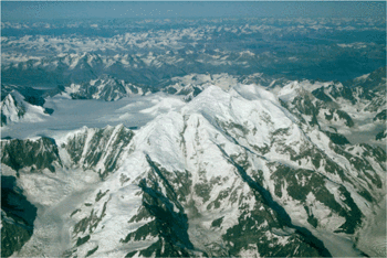 Aerial view of Mount Fairweather. (Source: United States Geological Survey)
 958,000 hectares (ha). The park is contiguous to Wrangell-St Elias National Park and Preserve (5,344,129 ha) Alaska, Glacier Bay National Park and Preserve (1,335,492 ha), Alaska, and Kluane National Park Reserve (2,201,500 ha), Yukon and Tongass National Forest (6,708,900 ha), Alaska.
Land Tenure
Under the jurisdiction of The Crown, Province of British Columbia. Land tenures include a trapline cabin, homestead, communication site, a trapline territory, and four trespasses; these can be managed under park status and are to be administered under Park Use Permits. The Champagne and Aishihik First Nations have filed a comprehensive land claim with the federal government which defines traditional territory, including most of the Tatshenshini-Alsek area in British Columbia.
Altitude
50 meters (m) to 4,663 m.
Physical Features
The park contains part of the geologically young St Elias mountains; this range includes Mount Fairweather, which at 4,663 m, represents the highest point in British Columbia. While the western portion of the park is dominated by the St Elias mountains and associated glaciers and icefields, the eastern portion consists of the lower elevation Alsek Ranges with large expanses of alpine tundra. The Tatshenshini-Alsek region contains the largest non-polar ice cap in the world, over 350 valley glaciers and an estimated 31 surge-type glaciers. The area is part of the most seismically active region in North America. The Tatshenshini-Alsek rivers and their wide U-shaped valleys are prominent natural features of the park.
Climate
Weather systems in the region are the product of two predominant forces. Originating in the west, cyclonic storms from the Gulf of Alaska result in 500-2,000 millimeters (mm) of annual precipitation and intense [../157132/index.html wind storms over the coastal mountains. The interior is dominated by drier, more stable air and intense winter cold. Summer water temperatures range between 4.4°C and 6.6°C.
Vegetation
The park consists of three biogeoclimatic zones: boreal white and black spruce, spruce-willow-birch, and alpine tundra. Two further subzones have been described: wet boreal white and black spruce; and, moist cool forested and scrub spruce-willow-birch. The Tatshenshini-Alsek area represents a region of unusual species richness where a number of biomes meet, with habitats including relatively warm, dry river bottoms; wet meadows; alpine tundra; and rock. Although the area has been described as complex, diverse and largely unexplained, there are a number of noteworthy features. In the mid and upper Tatshenshini valley, an unusual forest of poplar, dominated by an understory of slide alder and a forest floor carpet of 'northern' ground cone Boschniakia rossica occurs. The park contains 45 of the 600 rare vascular plant species found in British Columbia. Among these are Alaska Nagoon berry Rubus articus stellatus (R), fragile sedge Carex membranacea, wedge-leaved primrose Primula cuneifolia saxifragifolia (R), and Wright's golden saxifrage Chrysosplenium wrightii. A more complete listing of rare vascular plant species occurring in the park is found in Peepre.
Fauna
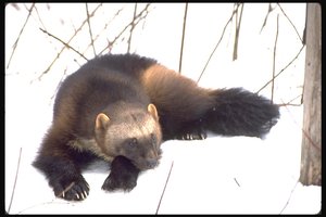 Wolverine: significant predator species in British Columbia. (Source: San Fransisco State University)
 The diversity (Species diversity) of vegetation in the area has resulted in the formation of habitats and the occurrence of certain species, particularly large predators and ungulates, rated as provincially and nationally significant. These include wolverine Gulo gulo; the "Blue" or "Glacier" bear Ursus americanus emmonsi, thought to be a colour phase of the black bear and found nowhere else in British Columbia or Canada, and considered rare in Alaska; and the area is acknowledged to be one of the last stronghold's of North America's grizzly bear population. About 200 of the known 400 Dall's sheep Ovis dalli dalli in British Columbia have their summer and winter range in this area. The park provides an important travel route for waterfowl, with at least 40 bird species known to use the region. These include trumpeter swan Cygnus buccinator and peregrine falcon Falco peregrinus, both considered vulnerable in Canada. Further, it is one of the few areas in the province where all four species of grouse are found. About 80 northern interior mammal and bird species occur, and include red fox Vulpes vulpes, Great gray owl Strix nebulosa, and bald eagle Haliaeetus leucocephalus. Amphibians expected in the region include the western toad Bufo boreas, and spotted frog Rana pretiosa, while reptiles are not found this far north. One butterfly identified is new to science and is a subspecies of the western meadow fritillary Clossiana epithore, and another insect, rare in British Columbia, the Arctic yellow jacket wasp Dolichovespula albida, is much darker than the common species. Peepre provides a more complete list of animals found in the park.
Cultural Heritage
Prior to the 19th century, evidence suggests that the Tutchone and Tlingit inhabited the Tatshenshini-Alsek area. The Tatshenshini River was used as a major travel and trading route, with the village of Neskatahin, located near Dalton Post, Yukon, serving as an important focal point. The Champagne and Aishihik First Nations are descendants of these people.
During the 1890's, Jack Dalton established the first white trading post in the Tatshenshini Basin, and following the establishment of the fur trade, the area was witness to the Klondike Gold Rush. In 1943/44 the Haines highway and parallel pipeline which today forms the eastern boundary of the park, were constructed from Haines, Alaska to Haines Junction, Yukon as a supply route for Alaska during World War II. Mineral exploration, mainly for copper and placer gold, has occurred sporadically since the 1930s, while intensive exploration in the 1980s led to the discovery of a large copper deposit at the head of Tats Creek (Windy Craggy) in the heart of the park. The development of the Cdn $430 million Windy Craggy project would have resulted in the hemisphere's largest open-pit copper and gold mine. The establishment of Tatshenshini-Alsek as a Class A wilderness park prevents any further mineral exploration or development, and will result in all mineral claims being extinguished.
Local Human Population
There are no roads or permanent settlements of any kind in the park, and no permanent residents. Subsistence fishing and hunting is carried out by the Champagne and Aishihik First Nations, primarily near Haines Highway. Most of these people currently live in the Yukon Territories.
Visitors and Visitor Facilities
Currently, 1,000 people per annum travel the Tatshenshini-Alsek rivers by raft. In addition to commercial river rafting, non-commercial river rafters, kayakers and canoers also use the area. Guided hunting is permitted.
Scientific Research and Facilities
A number of site-specific vegetation studies and faunal surveys have been conducted. Non-profit conservation groups such as the Sierra Club of Canada have undertaken preliminary biophysical and land-use research in the Tatshenshini.
Conservation Value
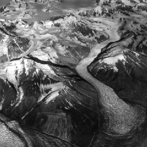 Glacier in the St. Elias Mountain range. (Source: University of Texas)
 As the wide valleys of the Tatshenshini and Alsek rivers pass through the St Elias mountains, they represent the only vegetated, low elevation and ice-free linkage for the migration of plant and animal species in the entire region. Further, the area is important in supporting [[population]s] of large mammal such as grizzly bear. The park is comprised of three natural regions which are not represented in any existing British Columbia protected area. In addition, many of the natural geological and biological features found in the area occur nowhere else in the province, and the wilderness recreation opportunities on the river system are outstanding. As Edward Glave commented at the end of his expedition in 1890, the river environs yielded 'such an incessant display of scenic wild grandeur that it became tiresome'.
The Tatshenshini-Alsek river system, recognized as potential Canadian Heritage Rivers, contributes 95% of the chinook salmon, 90% of the sockeye salmon and 75% of the coho salmon for the commercial fishery (Fisheries and aquaculture) in the Dry Bay area of the Gulf of Alaska. These fish stocks support a multi-million dollar industry. Further, this river system is one of only three major salmon-bearing rivers on the northern Pacific coast, with an important sustenance fishery for the people of the Champagne and Aishihik First Nations being found at Klukshu.
Conservation Management
The relatively inaccessible wilderness lands of Tatshenshini-Alsek will be managed to conserve, in perpetuity, natural diversity and cultural values, and provide outstanding opportunities for backcountry recreation, wildlife viewing, scientific research and education. As a Class A Provincial Park, all commercial resources exploitation is prohibited except that which enhances the area's natural values. Settlements, roads, and any activities incompatible with wilderness preservation are also prohibited.
The park is administered by the Ministry of Environment, Lands and Parks, although the area is subject to a land claim by the Champagne and Aishihik First Nations. Aboriginal rights and interests that exist in British Columbia for land and resource use are respected in [[protected area]s]. Aboriginal people have a legal right to use protected areas for traditional sustenance activities (including hunting, fishing and gathering) and for ceremonial and spiritual practices, subject to conservation objectives.
Under a coalition of over 50 conservation groups known as 'Tatshenshini International', it was during the 1980s and 1990s that a campaign was launched to protect the area from mining and to preserve it as wilderness. Despite there being 171 mineral claims which predate park designation, no further mineral activity will be permitted. Compensation for mineral tenures will be dealt with by the Ministry of Energy, Mines and Petroleum Resources, and the Ministry of the Attorney General. Any necessary reclamation of exploration workings will take place upon resolution of the compensation issue and in accordance with an interim management plan.
Apart from the Haines Highway corridor which occupies less than 5% of the area, the entire park will be zoned and managed for wilderness preservation. A Master Plan is to be developed for the park through open consultation with the public; in the meantime, an interim management plan will be prepared to provide management direction for park management zones, visitor use, recreation and conservation goals. The province of British Columbia will work with other governments to regulate use levels on the rivers by requiring users to hold a Park Use Permit.
The park represents a component of a very large international complex of designated wilderness, and cooperative management with adjacent park areas will ensure the protection and perpetuation of the wilderness ecosystems in this region. To this end, an International Accord has been proposed which will guide the Province of British Columbia, Yukon Territory, Government of Canada, First Nations and United States of America in future management of the 'St Elias-Tatshenshini World Wilderness Reserve', consisting of Wrangell-St Elias National Park, Glacier Bay National Park and Preserve, Kluane National Park Reserve, Tatshenshini-Alsek Provincial Wilderness Park, and the Yukon Champagne-Aishihik Special Management Area. This reserve would have the highest management standards in the world.
Management Constraints
With the growing interest in rafting, proper management and regulation are required to ensure that the values being protected are not damaged from overuse. In recent years, the river has experienced a 200% growth in tourism use.
Staff
One person will be located at Haines Junction from spring 1994. It is hoped that a member of the Champagne Aishihik will be hired as a counterpost.
Budget
River rafting expeditions on the Tatshenshini-Alsek River alone generates about Cdn$ 2 million in seasonal economic activity, most of which is a roughly equal split of revenue generated by Canadian and American outfitters.
IUCN Management Category
- II (National Park)
- Natural World Heritage Site - Criteria ii, iii, iv
Further Reading
- Adventure Travel Society (1993). Promoting Adventure Travel - Protecting the Environment (Fall 1993). 8pp.
- Askey, Ethan (1992). Tatshenshini-Alsek river use study. Simon Fraser University, Burnaby, British Columbia. (Unseen)
- British Columbia Commission on Resources and the Environment (1993). Interim report on Tatshenshini/Alsek land use, British Columbia ISBN: 0771893434. Volume One and Appendices. Victoria, British Columbia: The Commission. (Unseen)
- Government of Canada (1993). World Heritage Nomination: Tatshenshini-Alsek Wilderness Park. Parks Canada, Ottawa. 22 pp + maps and appendices. (Unseen)
- Herrero, Stephen, et al (1993). The conservation significance of bears and their habitat in the Tatshenshini River valley. University of Calgary, Alberta. (Unseen)
- Madsen, Ken (1991). Tatshenshini wilderness quest and other river adventures. Western Canada Wilderness Committee, Vancouver, British Columbia. (Unseen)
- Peepre, Juri S. and Associates (1986). Tatshenshini-Alsek Rivers recreation corridor assessment. J.S. Peepre and Associates. Vancouver, British Columbia. (Unseen)
- Peepre, Juri S. and Associates (1992). Tatshenshini-Alsek Region Wilderness Study. J.S. Peepre and Associates. Vancouver, British Columbia.
- Peepre, Juri S. and Associates (1993). Tatshenshini River (Shawske Chu) Yukon Territory - Canadian Heritage River System background study. Vancouver, British Columbia. (Unseen)
- Pojar, J. et al. (1993). Biodiversity inventory of the Tatshenshini-Alsek region. Ministry of Forest, Victoria, British Columbia. (Unseen)
- Robinson, Bart (1993). Big Rivers, Big People. In: Tatshenshini: River Wild. Raincoast Books, Vancouver, BC. Pp 33-38 ISBN: 1895714079.
| Disclaimer: This article is taken wholly from, or contains information that was originally published by, the United Nations Environment Programme-World Conservation Monitoring Centre (UNEP-WCMC). Topic editors and authors for the Encyclopedia of Earth may have edited its content or added new information. The use of information from the United Nations Environment Programme-World Conservation Monitoring Centre (UNEP-WCMC) should not be construed as support for or endorsement by that organization for any new information added by EoE personnel, or for any editing of the original content. |