Geography of Uganda
| Topics: |
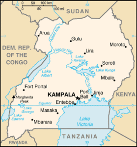 Map of Uganda. Source: CIA World factbook
 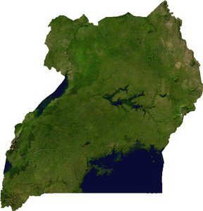 Satellite Image of Uganda. Source: Cwolfsheep/Wikipedia/The Map Library
  Topography of Uganda. Source: Sadalmelik/Wikipedia
 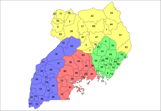 Political Districts of Uganda. Source: Rarelibra/Wikipedia
 Uganda is a landlocked country astride the equator, about 800 km inland from the Indian Ocean. It lies on the northwestern shores of Lake Victoria, extending from 1o south to 4o north latitude and 30o to 35o east longitude.
Uganda is bordered by Tanzania and Rwanda to the south, the Republic of the Congo] (formerly Zaire) to the west, Sudan to the north, and Kenya to the east. With a land surface of 241,139 square kilometers (roughly twice the size of the state of Pennsylvania), Uganda occupies most of the Lake Victoria Basin, which was formed by the geological shifts that created the Great Rift Valley during the Pleistocene era. The Sese Islands and other small islands in Lake Victoria also lie within Uganda's borders.
Land Use
In the southern half of the country, rich soil and rainfall permit extensive agriculture, and in the drier and less fertile northern areas, pastoral economies are common. Approximately 21 percent of the land is cultivated and 45 percent is woodland and grassland, some of which has been cleared for roads, settlements, and farmland in the south. Approximately 13 percent of the land is set aside as national parks, forests, and game reserves. Swampland surrounding lakes in the southern and central regions supports abundant papyrus growth. The central region's woodlands and savanna give way to acacia and cactus growth in the north. Valuable seams of copper, cobalt, and other minerals have been revealed along geological fault lines in the southeast and southwest. Volcanic foothills in the east contain phosphates (Phosphate rock) and limestone.
Mountains
Southern Uganda lies at an altitude of 1,134 meters above sea level. The plateau that stretches northward from Lake Victoria declines gradually to an altitude of 914 meters on the Sudan border. The gradually sloping terrain is interrupted by a shallow basin dipping toward the center of the country and small areas of tropical forest, which mark the western border with the Republic of the Congo].
Both eastern and western borders are marked by mountains. The Ruwenzori Mountains (often called the Mountains of the Moon) form about eighty kilometers of the border between Uganda and the Republic of the Congo]. The highest peaks of Mount Stanley, in the Ruwenzoris, are snowcapped . Foremost among these are Margherita (5,113 meters) and Alexandra (5,094 meters). Farther south, the northernmost of the Virunga (Mufumbiro) Volcanoes/Mountains reach 4,132 meters on Mount Mahavura; 3,648 meters on Mount Mgahinga; and 3,477 meters on Mount Sabinio, which marks the border with Rwanda and the Republic of the Congo.
In eastern Uganda, the border with Kenya is also marked by volcanic hills. Dominating these, roughly 120 kilometers north of the equator, is Mount Elgon, which rises from the 1,200-meter plains to reach a height of 4,324 meters. Mount Elgon is the cone of an extinct volcano, with ridges radiating thirty kilometers from its crater. Rich soil from its slopes is eroded into the plains below. North of Mount Elgon are Kadam (also known as Debasien or Tabasiat) Peak, which reaches a height of 3,054 meters, and Mount Moroto, at 3,085 meters. In the far northeast, Mount Zulia, Mount Morungole, and the Labwor and Dodoth Hills reach heights in excess of 2,000 meters. The lower Imatong Mountains and Mount Langia, at 3,029 meters, mark the border with Sudan.
Lakes and Rivers
Uganda is a well-watered country. Nearly one-fifth of the total area, or 44,000 square kilometers, is open water or swampland. Four of East Africa's Great Lakes -- Lake Victoria, Lake Kyoga, Lake Albert, and Lake Edward -- lie within Uganda or on its borders. Lake Victoria dominates the southeastern corner of the nation, with almost one-half of its 10,200-square-kilometer area lying inside Ugandan territory. It is the second largest inland freshwater lake in the world (after Lake Superior), and it feeds the upper waters of the Nile River, which is referred to in this region as the Victoria Nile.
Lake Kyoga and the surrounding basin dominate central Uganda. Extensions of Lake Kyoga include Lake Kwania, Lake Bugondo, and Lake Opeta. These "finger lakes" are surrounded by swampland during rainy seasons. All lakes in the Lake Kyoga Basin are shallow, usually reaching a depth of only eight or nine meters, and Lake Opeta forms a separate lake during dry seasons. Along the border with the Republic of the Congo], Lake Albert, Lake Edward, and Lake George occupy troughs in the western Rift Valley.
Leaving Lake Victoria at Owen Falls, the Victoria Nile descends as it travels toward the northwest. Widening to form Lake Kyoga, the Nile receives the Kafu River from the west before flowing north to Lake Albert. From Lake Albert, the Nile is known as the Albert Nile as it travels roughly 200 kilometers to the Sudan border. In southern and western Uganda, geological activity over several centuries has shifted drainage patterns. The land west of Lake Victoria is traversed by valleys that were once rivers carrying the waters of Lake Victoria into the Congo River system. The Katonga River flows westward from Lake Victoria to Lake George. Lake George and Lake Edward are connected by the Kizinga Channel. The Semliki River flows into Lake Edward from the north, where it drains parts of the Democratic Republic of the Congo and forms a portion of the Uganda-Democratic Republic of the Congo border.
Spectacular waterfalls occur at Murchison (Kabalega) Falls on the Victoria Nile River just east of Lake Albert. At the narrowest point on the falls, the waters of the Nile pass through an opening barely seven meters wide. One of the tributaries of the Albert Nile, the Zoka River, drains the northwestern corner of Uganda, a region still popularly known as the West Nile although that name was not officially recognized in 1989. Other major rivers include the Achwa River (called the Aswa in Sudan) in the north, the Pager River and the Dopeth-Okok River in the northeast, and the Mpologoma River, which drains into Lake Kyoga from the southeast.
Data
Location: Eastern Africa, west of Kenya
Geographic Coordinates: 1 00 N, 32 00 E
Area: 236,040 km2 (199,710 km2 land and 36,330 km2 water)
arable land: 21.57%
permanent crops: 8.92%
other: 69.51% (2005)
Land Boundaries: 2,698 km. Border countries: Republic of the Congo] 765 km, Kenya 933 km, Rwanda 169 km, Sudan 435 km, Tanzania 396 km
Coastline: 0 km (landlocked)
Maritime Claims: none (landlocked)
Terrain: Mostly plateau with rim of mountains. Its lowest point is Lake Albert (621 metres) and its highest point is Margherita Peak on Mount Stanley (5,110 metres)
Climate: Tropical; generally rainy with two dry seasons (December to February, June to August); semiarid in northeast
Capitol: Kampala
Regions of Uganda: The country is organized into 80 districts in 4 regions.
Further Reading
- Uganda: A country study, Edited by Rita M. Byrnes, Federal Research Division , Library of Congress (1990)
- Major rivers, lakes, mountains, and other terrestrial features of Uganda
- CIA Factbook
Return to the Uganda country profile
Return to the Africa Collection