Ecoregions of Zambia
Ecoregions of Zambia (WWF)
Ecoregions are areas that: [1] share a large majority of their species and ecological dynamics; [2] share similar environmental conditions; and, [3] interact ecologically in ways that are critical for their long-term persistence. Scientists at the World Wildlife Fund (WWF), have established a classification system that divides the world in 867 terrestrial ecoregions, 426 freshwater ecoregions and 229 marine ecoregions that reflect the distribution of a broad range of fauna and flora across the entire planet.
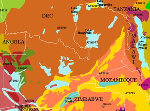 WWF Ecoregions of Zambia. Source: WWF
 The following WWF ecoregions are found in Zambia.
- Central Zambezian Miombo woodlands (AT0704) cover most of the country.It is one of the largest ecoregions in Africa, ranging from Angola up to the southern shores of Lake Victoria. All the typical miombo flora are represented here, but this region has a higher degree of floral richness, with far more evergreen trees than elsewhere in the miombo biome. The harsh dry season, long droughts, and poor soils are ameliorated by the numerous wetlands spread throughout the ecoregion, covering up to 30 percent of the region’s total area. As a result, a diverse mix of animals is found here, from sitatunga (swamp-dwelling antelopes), to chimpanzees, in the world-famous Gombe Stream Reserve. The bird life is also exceptionally rich, as is the fauna of some amphibian groups. The ecoregion contains areas of near-wilderness with exceptionally low human populations and extensive protected areas. Other parts of the ecoregion, typically close to lakes and mountains, have higher population densities and the miombo is much more degraded. Bushmeat hunting, dryland agriculture, deforestation especially for charcoal production near larger towns, and mining are increasing threat in this ecoregion.
- Itigi-Sumbu thicket (AT0708) is a unique but poorly understood ecoregion, best known for its impenetrably dense deciduous vegetation. It is found in two small areas in center of Tanzania and on the south edge of Lake Tanganyika in Zambia. The thick, primarily vegetation is so dense that elephants forcing their way through these thickets barely leave tracks, as the shrubs spring back to their original positions. While little research has been conducted, the Itigi-Sumbu Thicket’s vegetation is unique and contains a number of endemic plants. It was once vital habitat for the black rhino, although poachers have eradicated the rhino in this ecoregion. Human populations in the area are rapidly increasing and even the thicket contained in protected areas is converted for agricultural purposes. In fact, the Itigi-Sumbu Thicket is being transformed so quickly that the Zambian portion is predicted to disappear in the next twenty years if urgent conservation action is not taken.
- Zambezian flooded grasslands (AT0907) occur on the Bangwuelu/Luapala/Chambezi system in Zambia and a number of smaller [[floodplain]s and wetlands. The ecoregion is an anomaly of productivity and abundance in a landscape characterized by nutrient poor soil and vegetation. Unlike the surrounding Central Zambezian Miombo woodlands that generally support animals only in fairly low densities, the wetlands and floodplains of this ecoregion provide habitats to large numbers of animals, as food and water are abundant throughout most of the year. Large populations of water birds gather during the rainy season and numerous herd animals and carnivores still frequent the landscape. However, in a climate of rapid population growth and increasing need for land and natural resources, this delicate ecoregion may face increasing threat. Several conservation measures are urgently required for the ongoing survival of these wetland ecosystems and their biota.
- Zambezian and Mopane woodlands (AT0725) are dispersed throughout southern Zambia, bounded by the Luangwa River in the north occuring in the coountries to the south. Mopane tree woodlands mix with Zambezian woodlands in lower-elevation areas, often along major river valleys. Although the ecoregion, particularly the mopane communities, is considered to be poor in endemics, it supports some of the largest and most significant wildlife populations in Africa, particularly those of the endangered African elephant and critically endangered Black rhino. Important populations of predators are also found in the Zambezian and Mopane Woodlands. The abundance of wildlife can be largely attributed to the high level of protection in the ecoregion, in which more than 45 percent of the habitat is devoted to various forms of state and private conservation.
- Southern Miombo woodlands (AT0719) extend over the southern third of Zambia mized with areas of Zambezian and Mopane woodlands. The landscape is flat or gently undulating, with numerous inselbergs. Miombo woodland mixes with mopane and smaller wetlands to provide habitat for a wide variety of animals, including endangered and charismatic mammals such as African elephants and Black rhinos. While a number of protected areas fall within this ecoregion, management and resources are sometimes lacking. Poaching of ivory and rhino horn remains a persistent problem.
- Southern Rift montane forest-grassland mosaic (AT1015) occurs in a few spots on the eastern border with Malawi. Although it boasts fewer endemics than the Albertine Rift (Albertine Rift montane forests) and Eastern Arc Forests to the north, the Southern Rift Montane Forest-Grassland Mosaic ecoregion is by no means impoverished nor lacking in unique species. The Nyika Plateau is renowned for its rich orchid flora, and hosts an impressive array of wildlife, while Tanzania’s Kitulo Plateau is also botanically important. Numerous examples of endemic plant and animal taxa can be found throughout the ecoregion. With the exception of the Nyika Plateau, the ecoregion is poorly conserved, and is increasingly threatened by cultivation and overexploitation of both forest and grassland resources, activities which have already transformed large areas of the ecoregion.
- Western Zambezian grasslands (AT0724)are located in two main portions in southwestern Zambia, to the north and south of the Barotse floodplains. Many ungulates are found here, including the largest herd of Blue wildebeest in Zambia, which undertake a spectacular migration into Angola each year. The grasslands have been inhabited by people for centuries, but are adapted to some human disturbances such as fires, and have a long history of traditional sustainable management.
- Zambezian Cryptosepalum dry forests (AT0203) are distinctive evergreen forests is confined to an area around the Kabompo River in southeasterm Zambia. Dominated by Crypotsepalum exfoliatum pseudotaxus, this is the largest area of tropical evergreen forest outside the equatorial zone. Growing on infertile Kalahari sands and with no permanent surface water, the Cryptosepalum dry forest has remained relatively uninhabited. These forests represent a transition from Guineo-Congolian rain forest to Zambezian woodlands and are hence species-rich, but contain few endemics. The avifauna is especially rich, with a mixture of moist evergreen species, woodland species and wide-ranging species. However, little research has been conducted in this inaccessible region and basic ecological and habitat use assessments are still needed.
- Zambezian Baikiaea woodlands (AT0726) occur in the south east of the country, where deep Kalahari sands occur in a wide belt along the [[Angola]n]-Namibian border across to Zimbabwe, supporting dry deciduous forest dominated by Baikiaea plurijuga. The hot, semi-arid climate and nutrient-poor soils mean that this region is not suitable for farming, and thus it has retained some of its natural vegetation. Over 160 mammal species are found here, including ungulates and large predators. However, settlements occur along rivers, and the valuable Baikiaea plurijuga is sought after for the timber trade. The civil war in Angola and hostilities between Angola and Namibia in the Caprivi Strip further threaten the future of this ecoregion.
See also:
Ecoregions (collection)
Ecoregions of Tanzania (WWF)
Ecoregions of the Democratic Republic of the Congo (WWF)
Further Reading
- Bailey, Robert G. 2002. Ecoregion-Based Design for Sustainability. Springer-Verlag. New York, New York. 240pp., 100 illus. ISBN 0-387-95430-9
- Bailey, Robert G. 1998. Ecoregions: The Ecosystem Geography of the Oceans and the Continents. Springer-Verlag. New York, New York. 192pp., 107 illus., 10 tables. ISBN 0-387-98305-8
- Bailey, Robert G. 1996. Ecosystem Geography. Springer-Verlag. New York, New York. 216pp., 122 illus., 14 tables. ISBN 0-387-94586-5
- Commission for Environmental Cooperation, Ecological Regions of North America--Toward a Common Perspective, (Quebec, Canada, 1997), ISBN 2-922305-18-X
- Omernik, James M., 1995. Ecoregions: A spatial framework for environmental management. In: Biological Assessment and Criteria: Tools for Water Resource Planning and Decision Making. Davis, W.S. and T.P. Simon (eds.) Lewis Publishers, Boca Raton, FL. Pp. 49-62. ISBN: 0873718941.
- World Wildlife Fund, Ecoregions homepage, Accessed 1 May 2009.
Return to Zambia country profile
Return to Albertine Rift collection
More African country profiles
Return to the Africa Collection