Ecoregions of Chad
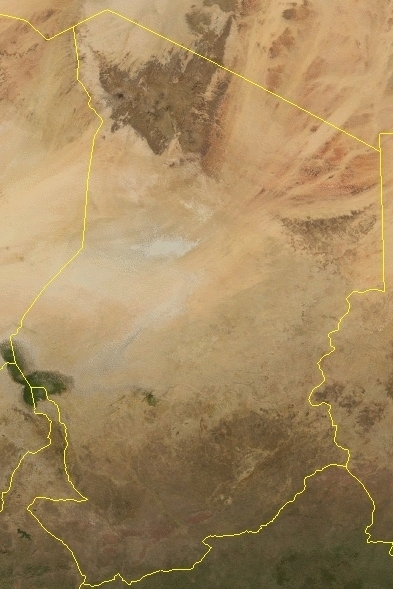
Source: NASA
Ecoregions of Countries Collection ![]()
Chad has seven ecoregions that occur entirely or partly within its borders:
- East Sudanian savanna
- Sahelian Acacia savanna
- Lake Chad flooded savanna
- East Saharan montane xeric woodlands
- [[South Saharan steppe and woodlands]
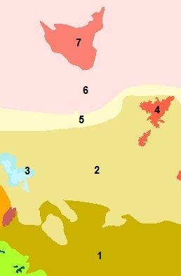 ]
] - Sahara desert
- Tibesti-Jebel Uweinat montane xeric woodlands
Contents
East Sudanian savanna
This ecoregion lies south of the Sahel in central and eastern Africa, and is divided into a western block and an eastern block by the Sudd swamps in the Saharan Flooded Grasslands ecoregion. The western block stretches from the Nigeria/Cameroon border through Chad and the Central African Republic to western Sudan. The eastern block is found in eastern Sudan, Eritrea, and the low-lying parts of western Ethiopia, and also extends south through southern Sudan, into northwestern Uganda, and marginally into the Democratic Republic of Congo around Lake Albert.
The East Sudanian Savanna is a hot, dry, wooded savanna composed mainly of Combretum and Terminalia shrub and tree species and tall elephant grass (Pennisetum purpureum). The habitat has been adversely affected by agricultural activities, fire, clearance for wood and charcoal, but large blocks of relatively intact habitat remain even outside protected areas. Populations of some of the larger mammal species have been reduced by hunting, but good numbers of others remain. Although numerous protected areas exist, most are under-resourced "paper parks" with little active enforcement on the ground, and some have suffered from decades of political instability and civil unrest. The poor infrastructure and inaccessibility of the region have resulted in little development of tourism and wildlife-related revenue generation schemes, with the notable exception of sport hunting in the Central African Republic. Considerable external support to this ecoregion from multilateral and bilateral aid agencies is likely to be needed for many years to maintain or improve current levels of biodiversity.
Sahelian Acacia savanna
The Sahelian Acacia Savanna stretches across Africa from northern Senegal and Mauritania on the Atlantic coast to Sudan on the Red Sea, varying in width from several hundred to over a thousand kilometers (km). The word "sahel" means "shore" in Arabic and refers to the transition zone between the wooded savannas of the south and the true Sahara Desert. The ecoregion thus lies south of the Southern Saharan steppe and woodland Ecoregion and north of the West and East Sudanian savanna Ecoregions.
Although not particularly rich biologically, these savannas once supported a large and diverse ungulate community. The first European explorers to visit the region found vast herds of game, even larger in number than those of eastern and southern Africa. Sadly, these herds have been reduced to mere remnants due to nearly a century of unregulated over-hunting with modern firearms and vehicles, coupled with habitat loss.
Lake Chad flooded savanna
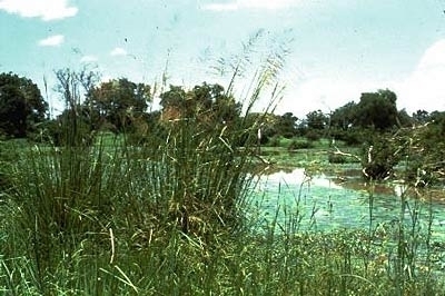 Lake Chad contains the boundaries of four African countries: Cameroon, Chad, Niger, and Nigeria. It is the largest lake in Central and West Africa and the fourth largest lake on the African continent. The lake’s waters presently cover 2,500 square kilometers (km2), only one-tenth the area they covered in the 1960’s.
This permanent shallow lake expands dramatically with seasonal floods, providing a vital refuge for birds migrating between the Palearctic and Afrotropical realms, and for resident animals. Up to one million waterbirds congregate on the lake in the Palearctic winter period. Located on the southern edge of the Sahara, Lake Chad is also critically important to the people who inhabit its shores. In recent years, these wetlands have come under increasing pressure from drought, plans for water resource projects, and intensified anthropogenic use. An estimated 20 million people rely on Lake Chad/ Hadejia-Nguru for their economic activities, a figure that is projected to rise to 35 million by the year 2020.
This ecoregion has highest biological importance for the large numbers of migrant birds that use the area, especially ducks and waders that spend the Palearctic winter period in Africa. Periodic counts of waterfowl and other species have been conducted in Chad and Hadejia-Nguru from 1955 to the present day. Seventeen species of waterfowl and 49 other wetland bird species are recorded, and abundance varies in different years with the size of the lake and wetlands conditions elsewhere in West Africa. The most abundant bird is the wader ruff (Philomachus pugnax), with more than one million seen on the lake at one time.
In July 2000, the Lake Chad Basin Commission (LCBC) met and declared all of Lake Chad a transboundary Ramsar site of international importance. A Global Environmental Facility (GEF) project has been approved for Ramsar designation, including a management plan for the lake and the basin.
The Lake Chad Basin contains some of the poorest countries in the world, and permanent infrastructure cannot be installed on the lake’s ever-fluctuating shores, compromising significant development. Because of the variable lake size, people living around its basin are chronically vulnerable to food instability. Pressures to utilize the lake’s and its tributaries’ water resources are high in this arid Sahelian region, and a number of ambitious irrigation projects have been planned. The South Chad Irrigation Project (SCIP) began in 1979 with the goal of irrigating the lands surrounding Lake Chad. The project has a gross area of 660 km2 and would divert approximately 3 percent of the annual inflow to the lake. While two of the three stages of the project have been completed, the project was put on hold during the disastrous droughts. The installations are being maintained in good condition awaiting the recovery of the lake.
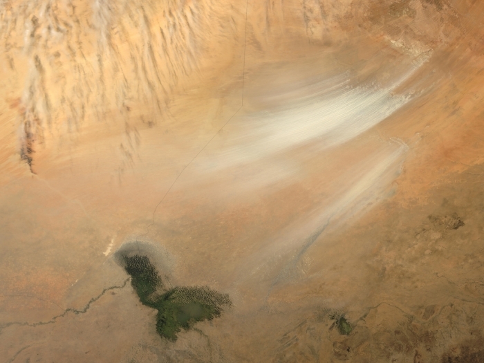
Once serving as part of the floor for a much larger Lake Chad, the area now known as the Bodele Depression, located at the southern edge of the Sahara Desert in north central Africa, is slowly being transformed into a desert landscape. In the mid-1960s, Lake Chad was about the size of Lake Erie. But persistent drought conditions coupled with increased demand for freshwater for irrigation have reduced Lake Chad to about 5 percent of its former size. As the waters receded, the silts and sediments resting on the lakebed were left to dry in the scorching African sun. The small grains of the silty sand are easily swept up by the strong wind gusts that occasionally blow over the region. Once heaved aloft, the Bodele dust can be carried for hundreds or even thousands of kilometers.
The remnants of Lake Chad appear as the olive-green feature set amid the tan and light brown hues of the surrounding landscape where the countries of Chad, Niger, Nigeria, and Cameroon all share borders. The Bodele Depression was the source of some very impressive dust storms that swept over West Africa and the Cape Verde Islands in early February.
These true-color images were acquired by the Moderate Resolution Imaging Spectroradiometer (MODIS) on February 7, and February 11, 2004. Numerous fires are shown as red dots in the February 7 images.
Credit Jacques Descloitres, MODIS Rapid Response Team, NASA/GSFC
East Saharan montane xeric woodlands
This ecoregion is located in the Sahelian regional transition zone where high mountains rise from the low-lying semi-desert [[habitat]s]. The height of these mountains creates an environment unlike that of the surrounding areas; here water is not scarce and sand does not dominate the soil structure. This isolated rugged habitat supports endemic plant and small animal species, and provides critical habitat for populations of some larger antelopes, such as the threatened addax (Addax nasomaculatus), dama gazelle (Gazella dama), dorcas gazelle (Gazella dorcas), and red-fronted gazelle (Gazella rufifrons).
The largest portion of the East Saharan Montane Xeric Woodland ecoregion is located in Chad, where it encompasses the Massif Ennedi and Massif du Kapka at over 1,400 meters (m) elevation. A smaller outlier of this ecoregion is located in Sudan, the Jebel Marra, which reaches heights over 3,000 m. This ecoregion, comprised of two isolated areas, supports dry woodland vegetation surrounded by Sahel Acacia wooded grassland and deciduous bushland. Happold found that the high jebels, which support areas of moisture-dependent habitat instead of desert and semi-desert, are more likely to have a higher biodiversity value.
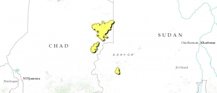
Human activities are not believed to be currently threatening the [[habitat]s] of this ecoregion, although recent reports are not readily available. Most of the agriculture once practiced in the area has been abandoned, resulting in regeneration of the landscape into more natural habitat (although not the original Olea laperrinei scrub forest type). This cannot be said of the fauna, as the larger animal species have been either removed or reduced to very small populations by hunting or competition with livestock and drought. One World Conservation Union (IUCN) category I-IV protected area the Fada Archei forest reserve in Chad also lies in part of this ecoregion.
South Saharan steppe and woodlands
This ecoregion covers a narrow band on the southern edge of the Sahara Desert, stretching from central Mauritania to the Red Sea. Annual grazing after rainfall is a key feature, in former times attracting large herds of arid-adapted migratory ungulates such as gazelles, addax, and scimitar-horned oryx. Much of the ecoregion is now overgrazed by herds of domestic livestock, and habitat degradation (Land-use and land-cover change) is widespread. Motorized hunters have decimated the wild ungulate herds, and the ecoregion's few protected areas have suffered from civil and international wars. Continued and increased external support is required to protect the ecoregion and provide alternate livelihoods and supplemental incomes for local people.
The Aïr and Ténéré National Nature Reserve in Niger and the Ouadi Rimé-Ouadi Achim Faunal Reserve in Chad are the two most important protected areas in the Sahelian subdesert zone of Africa. They probably contain the last viable populations of many of the larger ungulates of this ecoregion. However, both reserves have been plagued by political insecurity and civil unrest, and the current situation of their wildlife is far from certain. There are no protected areas in this ecoregion in Mauritania, Mali or Sudan, leaving huge expanses of habitat unprotected.
Sahara desert
The Sahara Desert is the largest hot desert in the world and occupies approximately ten percent of the African continent. The ecoregion includes the hyper-arid central portion of the Sahara where rainfall is minimal and sporadic. Although species richness and endemism are low, some highly adapted species do survive with notable adaptations. Only a few thousand years ago the Sahara was significantly wetter, and a significant large mammal fauna resided in this area. Climatic desiccation over the past 5000 years, and intense human hunting over the past 100 years, has obliterated most of these fauna. Now, in vast portions of the Sahara, merely rock, sand and sparse vegetation are found. The remnant large mammal fauna is highly threatened by ongoing over-hunting. An alternative name of the Sahara is the Great Desert.
The Sahara is a vast area of largely undisturbed habitat, principally sand and rock, but with small areas of permanent vegetation. The most degradation is found where water (oases, etc) is present. Here, [[habitat]s] may be heavily altered by human activities. Previously existing tree cover has often been removed for fuel and fodder by nomadic pastoralists and traders.
Tibesti-Jebel Uweinat montane xeric woodlands
Near Zouar, Chad Photograph by Bärbel and Bernd Jacobi The Tibesti-Jebel Uweinat Montane Xeric Woodland ecoregion is an island of higher biodiversity rising from the dry, harsh Sahara Desert in North Africa.
Many parts of this ecoregion are yet to be fully explored due to civil unrest between Chad and Libya, and the remote location of the area.
The known flora and fauna includes endemic species and highly endangered antelopes, such as the addax and the scimitar-horned oryx, the latter of which is now believed extinct in the wild.
This ecoregion is made up of two isolated montane areas in the central part of the Sahara Desert. Lying halfway between Lake Chad and the Gulf of Syrte, the larger Tibesti Mountains area is found in the northern portion of Chad, and extends marginally into southern Libya. The Tibesti Mountains consist of seven inactive volcanoes, with the highest peak reaching 3,415 meters (m). The second, smaller area is the Jebel Uweinat, located further to the east along the intersection of eastern Libya, southwestern Egypt, and northwestern Sudan.
The steep, rough terrain of this ecoregion, and its location deep within the Sahara Desert make it relatively intact. Almost all species, both plant and animal, can seek refuge in remote parts of the ecoregion. Currently there are almost no people living in the area, allowing vegetation to regrow from previous degradation caused by grazing. Nomadic people and soldiers still use resources, however, and practice unregulated hunting. Climatic desiccation over thousands of years has affected the vegetation of the area, as with other parts of the Sahara.
Although habitats are largely unthreatened, an established protected area may be needed in the long run to conserve the species and habitats in this ecoregion. Hunting continues to be a major threat to large mammals. Since its war with Libya ended in 1987, Chad has been fairly stable politically, with only occasional security problems in the North. Fighting between armies along the border of Libya and Chad occurs mainly in the Tibesti Mountains, with one group even referred to as the Tibesti rebels. Reports noting the heavy use of landmines in the area have led to the assumption that some species loss is occurring. This political and economic instability limits the resources available for protection of the habitats and biodiversity located in this ecoregion. Even with the end of the war, time will have to pass before the region is stable enough for surveys and conservation work to be carried out.
The most recent study of the fauna of the Jebel Uweinat is that of Leonard, who studied the effects of grazing by Dorcas gazelle (Gazella dorca) and Barbary sheep (Ammotragus lervia) on the vegetation of the area. Dorcas gazelles mainly graze on the lower parts of the sandstone [[habitat]s], and were not found to have an impact on plant distribution. However, moufflon overgraze the higher parts of the massif where the flora is poor, leading to the decline of high altitude plant species and an increase in inedible species.
Context
Ecoregions are areas that:
[1] share a large majority of their species and ecological dynamics;
[2] share similar environmental conditions; and,
[3] interact ecologically in ways that are critical for their long-term persistence.
Scientists at the World Wildlife Fund (WWF), have established a classification system that divides the world in 867 terrestrial ecoregions, 426 freshwater ecoregions and 229 marine ecoregions that reflect the distribution of a broad range of fauna and flora across the entire planet.