Eastern Zimbabwe montane forest-grassland mosaic
Eastern Zimbabwe montane forest-grassland mosaic (WWF)
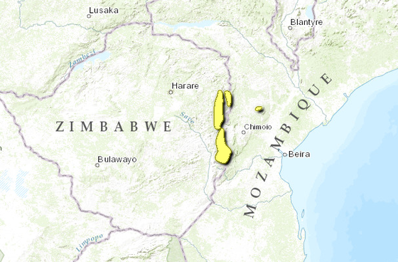
The Eastern Zimbabwe montane forest-grassland mosaic ecoregion spans the border between Mozambique and Zimbabwe; the mountains within this relatively small ecoregion form part of a larger mountain chain that extends through much of Africa, from the Ethiopian highlands to the Drakensberg Mountains in South Africa. These mountains consist of a complex mosaic of forests, woodlands, and grasslands that demonstrate strong floristic links to the surrounding areas of East and Southern Africa. The fauna also shows affinities to the mountains of these areas, although several endemic animals are found here as well. The characteristic rainy and foggy climate makes this region suitable for coffee, tea, and dairy farming as well as exotic timber plantations. However, the steep and largely inaccessible nature of these mountains has preserved native vegetation, as has the large Chimanimani National Park.
Location and General Description
The major portion of this ecoregion runs along the border between Zimbabwe and Mozambique. In Zimbabwe, this area is known as the "Eastern Highlands." The northernmost area is situated in the Inyanga Highlands. From here, the ecoregion moves south through the Vumba Highlands (near the town of Mutare) to the Chimanimani Mountains and then to the Chipinge Highlands in the south, which include Chirinda Forest (on Mount Selinda). A small isolated portion of the ecoregion is located in Mozambique at Mount Gorongoza.
 WWF
WWF
This montane forest-grassland mosaic is wetter than the surrounding areas as a result of higher rainfall, characteristic low cloud cover, early morning mist and heavy dew. These conditions result from the higher topographic features forcing the predominant moist oceanic air masses from the southeast to rise and cool. Moisture held by the air condenses and falls as rain or forms low clouds from which forest vegetation can extract moisture through condensation. The annual rainfall in the ecoregion is highly variable, from 741 to 2997 millimetres per year. This variability is largely related to aspect, with east-facing slopes receiving higher rainfall than those facing west. Most of the precipitation occurs in the austral summer months from November to April, while the austral winter months from May to July are drier. From August until the rains arrive in November, temperatures increase. It is during this time that extensive grass fires occur in the high-elevation grasslands. Frequent night frosts occur during the winter months, becoming heavier as elevation increases. The annual mean temperatures range from a minimum of 9° to 12° Celsius (C) to a maximum of 25° to 28° C.
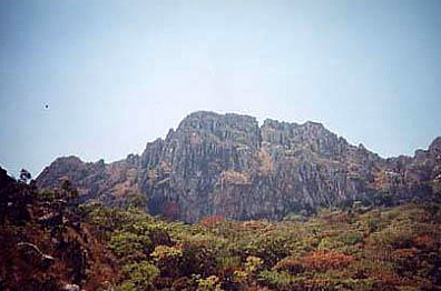
The highlands of this ecoregion form a small link in the chain of mountains that run throughout eastern Africa. This stretches from the Cape Province and the Drakensburg in South Africa through to the Nyika Plateau of Malawi, the Rift Mountains along Lake Tanganyika and the isolated massifs of East Africa, and finally to the Ethiopian Highlands in the north. The geology of the area is dominated by the Precambrian Umkondo system, which consists of flat-lying shales, quartzites and intrusive dolerites. It has a drainage pattern of deeply cut valleys, heavily affected by east-west faulting with flat-topped or rounded hills. In contrast, the Chimanimani Mountains, with their rugged peaks and schists, are formed from the ancient metamorphic rocks of the Frontier system. These mountains are bounded to the west by a vertical fault extending through the Umkondo system. The entire ecoregion is over 1000 meters (m) in elevation with a maximum elevation of 2592 m in the northern portion and 2436 m in the southern portion. The isolated Gorongoza Mountain in Mozambique rises to 1863 m.
The watersheds for two major rivers, the Zambezi River in the north and the Save River in the south, are located within the highlands making up this ecoregion. Rivers that originate in the highlands to the north of the ecoregion (such as the Gairezi and Inyangambe Rivers) meet the Zambezi River just past the town of Tete in Mozambique. The Zambezi then flows into the Indian Ocean south of the village of Chinde on the Mozambique Coast. The highlands to the south of the ecoregion form the eastern watershed for the Save River which flows south around the ecoregion and then east, across Mozambique, flowing into the Indian Ocean near the small town of Machanga.
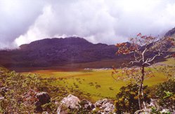 Chimanimani National Park, Zimbabwe (Photograph by Miranda Mockrin) The most predominant vegetation type of this ecoregion is the submontane and montane grassland, which covers the extensive rolling hills that make up a large portion of the area. At higher elevations it is a short, tufted grassland of low ground cover dominated by Loudetia simplex, Trachypogon spicatus, Exotheca abyssinica, and Monocymbium ceresiiforme. At lower elevations Themeda triandra is dominant on the more fertile red soils and Loudetia simplex is dominant on the poorer white sands.
One of the more distinctive vegetation types occurring in this ecoregion is the relict moist evergreen forest, which occurs on east-facing mountain slopes and in the deep valleys and ravines below 1500 metres (m). This forest type has also been described as rain forest as it is dependent on atmospheric moisture rather than groundwater for its water requirements. Small patches of moist evergreen forest occur on the eastern slopes of the Inyangana Mountains and also on the Chimanamani, Vumba and Gorongoza Mountains. The best-known and largest patch of this forest is Chirinda Forest, situated between 1076 m and 1250 m on Mt. Selinda, 48 kilometres south of Chipinga. Outside of this ecoregion small relicts of similar rain forest are also found in northern Zambia and Malawi.
These forests are essentially subtropical, but have the structure of a typical rain forest of the moist tropics. The canopy is 40 to 55 metres high, and lianas are common. These forests have a well-developed structure consisting of five strata: the canopy, the sub-canopy, the sapling layer, the shrub layer and the ground layer. The dominant canopy species are Fluted milkwood (Chrysophyllum gorungosanum), Craibia brevicaudata and Khaya anthotheca. The reknowned "big tree" of Chirinda is a Khaya, species, reaching a height of 65 m. It is robustly buttressed and measures about 4.5 metres in diameter. The sub-canopy comprises Tannodia swynnertonii, Strychnos mellodora and Drypetes gerrardii, while the sapling layer is broad, consisting of many young canopy trees and others that do not reach the canopy such as Heinsenia diervilleoides, Rothmannia urcelliformis and Pleiocarpa pycnantha. The shrub layer is dominated by Dracaena fragrans and various woody herbs of the family Acanthaceae.
A second forest type, dry montane forest, is more widespread within the ecoregion. This forest is dependent on ground water for its water supply and is therefore restricted to areas of permanent ground water. It is found at higher altitudes than the moist evergreen rain forest, from about 1500 m to 2000 m. The forest has a well-developed tree layer with an average canopy height of about 12 to 15 metres (m). The individual trees are rarely large, most trunks being between 5 and 30 centimetres in diameter at breast height. No particular tree species dominates, but Erythrophleum suaveolens, Blighia unijugata, Zanha golungensis, and Melanodiscus oblongus are common. Lianas (woody climbers) are numerous with Saba comorensis and Paullinia pinnata dominating. The forest floor is usually in deep shade and the herbaceous flora is sparse. Epiphytes and lithophytes are abundant, and practically every branch, trunk or rock is covered by a dense growth of bryophyta in which are set small plants such as Asplenium aethiopicum, A. rutaefolium, Elaphoglossum aubertii, Hymenophyllum kuhnii, Lycopodium spp., Polypodium spp., Streptocarpus spp., Vittaria spp., and orchids. At higher elevations the climate becomes drier and the vegetation grades into a more sclerophyllous forest with gymnosperms such as Widdringtonia cupressoides, W. whytei, Podocarpus milanjianus, and Juniperus procera dominating. Lianas become sparse but the epiphytic bryophytes and Streptocarpus species remain.
Miombo woodlands are scattered throughout the ecoregion, occurring on well-drained slopes up to an elevation of 2,100 m. These woodlands vary from closed to open and are dominated by the deciduous Brachystegia spiciformis, B. tamarinodoide, and Uapaca kirkiana. The trees are fairly small, from 3-6 m in height. The ground flora consists of grasses such as Digitaria diagonalis, Loudetia simplex, and Themeda triandra, dicotyledonous herbs, ferns (particularly brackenfern Pellaea spp.) and creepers such as Smilax kraussiana.
In the southern portion of the ecoregion around Chipinge, as well as along the western slopes of the Inyanga Highlands and on the southern slopes of Mt. Gorongoza, there occurs a very distinctive vegetation type, a semi-evergreen high rainfall tree savanna. This savanna is dominated by Parinari curatellifolia, an evergreen tree growing to about 15 m tall. P. curatellifolia usually forms monospecific stands in this vegetation type, but is sometimes associated with Faurea speciosa and F. saligna.
On the Chimanimani and Gorongoza Mountains, above about 1200 m, heathlands are found. These are restricted to the poor, acidic quartzite-derived sands. Phipps and Goodier classify these heathlands into ericaceous and proteaceous types. The ericaceous heathlands are dominated by Philippia pallidiflora, P. hexandra, Phylica ericoides, Passerina montana, Erica eylesii, E. pleiotricha, E. gazensis and E. johnstoniana. The proteaceous heathlands are dominated by Protea gazensis, P. welwitschii, and Leucaspermum saxosum.
These different vegetation types result in large part from the influences of fire, water availability, soil type and frost. Grasslands are maintained through annual fires that occur towards the end of the dry season (from August to October). Where fire has been excluded, forest precursors have been found to invade. The dry montane forests are restricted to areas of high ground moisture, requiring permanent ground water to survive the dry season. They are consequently found along perennial streams where the soil is well drained. The presence of water produces a humid habitat in which there is abundant green growth throughout the year, which is not particularly susceptible to burning. The river glens are also topographically protected from fire and from frost. The woodlands occur on soil that is well drained but that does not have permanent ground water, drying out by the end of the dry season. The dominant tree species of the woodlands are fire-resistant, though the sparse ground flora ensures that fire does not sweep through the woodlands with the same intensity as through the adjacent grassland. The small patches of moist evergreen rain forest are restricted to areas where there is sufficient atmospheric moisture year-round. This water is derived from the highlands catching moist oceanic air from the southeast in the form of rain, low clouds and morning mist or dew. The closed canopy also helps to maintain the moist environment inside the forest. In addition, the rain forests are restricted to dolerite-derived red clay soils, which are highly moisture retentive.
Biodiversity Features
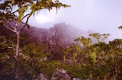 Chimanimani National Park, Zimbabwe (Photograph by Miranda Mockrin)
 The high species richness in plant and animal groups is a result of the complex mosaic of different vegetation types found within this ecoregion. In terms of the classification of White, these highlands form part of the Afromontane center of endemism. This phytogeographical region is mostly made up of a chain of mountains stretching from the Ethiopian Highlands in the north to the Cape in South Africa. The Afromontane region has a high level of species endemism, but poorly developed endemism at the levels of genus and family. Many of the endemic species are widely distributed throughout the Afromontane region, and are hence present in several [[ecoregion]s]. Because there are major present-day barriers to dispersal between even relatively close mountain groups (such as the low-lying, hot, dry Zambezi, Save and Limpopo River valleys) these species are considered to be relicts from a time when montane forests were widespread.
In addition to their affinities with other Afromontane forests across Africa, the flora and fauna of this ecoregion also have strong links with the East African coastal forests (Zanzibar to Inhambane) and with the South African coastal forests (Tongoland-Pondoland region). This is particularly true of the lower elevations of the forest.
While there are no spectacular mammals found only in this ecoregion, there are some interesting non-endemic species present. The arboreal blue monkey (Cercopithecus mitis) is a conspicuous forest dwelling species, noisily moving and foraging within the upper canopy. Other forest canopy mammals include the rare tree civet (Nandinia binotata), squirrels such as the sun squirrel (Heliosciurus mutabalis) and the red squirrel (Paraxerus palliates), bushbabies such as thicktailed bushbaby (Otolemur crassicaudatus), and fruit bats (including the rare Myonycteris relicta). In the understory, the blue duiker (Cephalophus monticola), common duiker (Sylvicapra grimmia), bushpig (Potamochoerus porcus), dark-footed forest shrew (Mysorex cafer) and the four-toed elephant shrew (Petrodomus tetradactylus) are found.
The Samango monkey, tree civet, sun squirrel and East African little collared fruit bat (Myonycteris relicta) are species that illustrate the affinity of the forests of this ecoregion with those of the East African Coast. Leopards (Panthera pardus) are found throughout this ecoregion, moving between the different vegetation types. The more open grasslands and heathlands contain fewer mammal species, with the klipspringer (Oreotragus oreotragus), sable antelope (Papio cynocephalus), eland (Taurotragus oryx) and hyraxes (Procavia capensis) being the most conspicuous. Two mammal species are endemic to the ecoregion -- the Selinda rat (Aethomys silindensis) and Arend’s golden mole (Chlorotalpa arendsi). The Selinda Rat is extremely rare. To date, fewer than ten specimens of this species are known, three from Chirinda Forest and seven from Stapleford Forest near Nyanga.
A rich and varied birdlife is found here, including forest species such as the trumpeter hornbill (Bycanistes bucinator), Knysna and purple-crested louries (Tauraco corythaix, T. porphyreolophus), crested guineafowl (Guttera pucherani) and the crowned eagle (Stephanoaetus coronatus). The grasslands support species such as the secretary bird (Sagittarius serpentarius) and Shelly’s francolin (Francolinus shelleyi). In the heathlands of the Chimanimani Mountains, Fynbos species such as Gurney’s sugarbird (Promerops gurneyi) and the malachite sunbird (Nectarinia famosa) can be seen. Two endemics, the Chirinda apalis (Apalis chirindensis) and Roberts’ prinia (Prinia robertsi), and one rare near-endemic Swynnertons Robin (Swynnertonia swynnertonia VU) occur in this ecoregion. The Chirinda apalis is restricted to the deep forest whereas Roberts’ prinia is found on the forest margins.
Butterflies are a characteristic element of the forests of this ecoregion. After the rains, numerous species fill the air. The more noticeable belong to the genus Papilio. The largest are the emperor swallowtail (Papilio ophidicephalus) and the citrus swallowtail (P. demodocus). Other large and attractive species common in these forests belong to the Nymphalidae family, for example the forest king charaxes (Charaxes xiphares), the golden-banded forester (Euphaedra neophron) and the forest green (Euryphura achlys).
Most of this ecoregion's amphibian and reptile species live in the forests. Many of the species are terrestrial, finding shelter in the forest leaf litter and inside rotting logs. These species include skunks, geckos, lizards, frogs, toads, and some snakes. Terrestrial forest snakes include the African rock python (Python sebae natalensis, VU), the Gabon viper (Bitis gabonica gabonica, VU) and the forest cobra (Naja melanoleuca). The Inyangani river frog (Amietia inyangae) is a restricted range montane species endemic to this ecoregion, having been observed here at elevations only above 2000 metres. this anuran lives near rapidly flowing streams in montane grassland, where rock beds or rock armouring are prominent. There are a number of other anurans that inhabit the Eastern Zimbabwe montane forest-grassland grassland ecoregion. These anurans include Tschudi’s African Bullfrog (Pyxicephalus adspersus), Striped Frog (Rana fasciata), Silver-banded Banana Frog (Hyperolius tuberilinguis), Kihengo Screeching Frog (Arthroleptis stenodactylus), and the Chirinda Screeching Frog (Arthroleptis xenodactyloides).
Arboreal forest species include chameleons, the tree agama (Agama atricollis), the yellow-spotted tree frog (Leptopelis flavomaculatus), and tree snakes. The most common arboreal snakes are the green mamba (Dendroaspis angusticeps) and the boomslang (Dispholidus typus typus). The grasslands and heathlands support a number of snakes such as the puff adder (Bitis arientans arientans) and the herald snake (Crotaphopeltis hotamboeia). Six amphibian and eight reptile species are strictly endemic to the ecoregion.
Current Status
The moist evergreen rain forests were previously much more widespread. They occur on the lower, fertile, well-watered slopes of the highlands. These were the same qualities sought by early settlers and also by indigenous subsistence farmers. As a result, most of these moist evergreen forests were cleared for agriculture over the last 100 years. Chirinda Forest is by far the largest remaining area and is well protected as the Chirinda Forest Botanical Reserve, which includes six km2 of rain forest. There are a few small relicts of rain forest that are protected in the Bunga Forest, the Vumba Botanical Reserves, and in the Nyanga National Park, which recently acquired further lowland rain forest behind Mt. Inyangani.
The higher altitude vegetation types are relatively well protected. The Chimanimani National Park, which covers an area of 171 km2, is perhaps the most important protected area in the ecoregion, as it includes representative portions of all the vegetation types making up the ecoregion. In particular, it conserves the high-elevation heathland vegetation that, in this ecoregion, occurs only on the Chimanimani and Gorongoza mountains. The dry montane forest is also well protected, with an estimated 120 km2 of this forest within the park. This forest type naturally has a highly fragmented distribution within the forest-woodland-grassland mosaic. Most of the Nyanga National Park, which covers an area of 471 km2, is situated at an elevation of between 2,000 m and 2,300 m. Consequently, this park is also important in conserving the higher elevation vegetation types. There is one protected area in Mozambique, the 3,750 km2 Gorongoza National Park. The Zimbabwe and Mozambican governments are working towards cooperative efforts to conserve these forests.
Types and Severity of Threats
The most threatened part of the ecoregion is the lowland moist evergreen rainforest. These lowland forests occur on fertile, well-watered slopes that are ideal for farming. Much of this forest vegetation has been cleared for tea and coffee plantations and for dairy farming. This is particularly prevalent in the Rusitu and Pungwe valleys, and the Chipinge and Vumba areas. There are still patches of unprotected forest in these areas that could be lost to clearing for agriculture. In addition, on the disturbed margins of the forest, alien species such as Lantana camara, Mauritius thorn (Caesalpinia decapetala), wattle (Acacia mearnsii), and eucalyptus species are invading, thereby threatening the biodiversity of the forests. Threats to the Chirinda Forest Reserve include poaching (particularly for blue duiker and guineafowl), the collection of firewood and the gathering of traditional herbal medicines. Landmines were planted in this ecoregion during Mozambique’s civil war and the Zimbabwean war of independence. They are primarily on the Mozambican side of this ecoregion.
These dry montane forests, grasslands, woodlands and heathlands are under threat from clearing for livestock grazing, timber plantation development and human settlement pressures. These vegetation types have not been favored farming, and have had a low population density; however, the human population explosion is placing increasing pressure on such more marginal lands.
Justification of Ecoregion Delineation
The boundaries for this ecoregion are taken from the ‘undifferentiated montane vegetation unit’ of White, and includes the Inyangani Highlands, Vumba Highlands, Chimanimani Mountains, Chipinge Uplands, and the isolated Mount Gorongosa to the east. It is noted as both an Endemic Bird Area and Center of Plant Diversity.
Additional Information on this Ecoregion
- To see the species that live in this ecoregion, including images and threat levels, see the WWF Wildfinder description of this ecoregion.
Further Reading
- Broadley, D.G. 1994. Reptiles of the Chirinda forest. In Chirinda Forest – a visitors guide. Forestry Commission, Harare.
- Burgess, N.D. and G.P. Clarke, editors. 2000. Coastal Forests of Eastern Africa. IUCN, Cambridge and Gland. p.443. ISBN: 2831704367
- Gardiner, A. 1994. Insects of the Chirinda forest. In Chirinda Forest – a visitors guide. Forestry Commission, Harare.
- Hogan, C. Michael. 2014. Amietia inyangae. African Amphibians. ed. B. Zimkus
- Killick, D.J.B. 1979. African mountain heathlands. Heathlands and Related Shrublands. Ecosystems of the World 9A. R.L. Specht, editor. Elsevier, Amsterdam.
- Phipps, J.B. and R. Goodier. 1962. A preliminary account of the plant ecology of the Chimanimani Mountains. Journal of Ecology 50: 291-319.
- John Poynton 2004. Amietia inyangae. In: IUCN 2012. IUCN Red List of Threatened Species. Version 2012.2.
- Sinclair, I. and P. Hockey. 1996. Sasol: The Larger Illustrated Guide to Birds of Southern Africa. Struik, Cape Town. ISBN: 0691044694
- Stattersfield, A.J., M.J. Crosby, A.J. Long, and D.C. Wege. 1998. Endemic Bird Areas of the World. Priorities for Biodiversity Conservation. BirdLife Conservation Series No. 7. BirdLife International, Cambridge, UK. 846 pp. ISBN: 1560985747
- Stuart, C. and T. Stuart. 1992. Guide to the Southern African Game and Nature Reserves. Struik, Cape Town. ISBN: 0844289663
- Timberlake, J. 1994. Physical features of the Chirinda forest. In Chirinda Forest – a visitors guide. Forestry Commission, Harare.
- Timberlake, J. and C. Musokonyi. 1994. Forest conservation and utilization. Chirinda Forest – a visitors guide. Forestry Commission, Harare.
- Timberlake, J. and P. Shaw. 1994. Introduction to Chirinda forest. In Chirinda Forest – a visitors guide. Forestry Commission, Harare.
- Timberlake, J., T. Muller and I. Mapaure. 1994. Vegetation of the Chirinda forest. Chirinda Forest – a visitors guide. Forestry Commission, Harare.
- White, F. 1978. The Afromontane region. Biogeography and Ecology of Southern Africa. W.J.A. Werger, editor. Junk, The Hague.
- White, F. 1983. The vegetation of Africa, a descriptive memoir to accompany the UNESCO/AETFAT/UNSO Vegetation Map of Africa (3 Plates, Northwestern Africa, Northeastern Africa, and Southern Africa, 1:5,000,000). UNESCO, Paris.
- Wild, H. and A. Fernandes. 1968. Vegetation Map of the Flora Zambesiaca Area. Flora Zambesiaca supplement. Salisbury: M.O. Collins.
- WWF and IUCN. 1994. Centres of plant diversity. A guide and strategy for their conservation. Volume 1. Europe, Africa, South West Asia and the Middle East. IUCN Publications Unit, Cambridge, U.K.
| Disclaimer: This article contains certain information that was originally published by the World Wildlife Fund. Topic editors and authors for the Encyclopedia of Earth have edited its content and added new information. The use of information from the World Wildlife Fund should not be construed as support for or endorsement by that organization for any new information added by EoE personnel, or for any editing of the original content. |