East Afghan montane conifer forests
The East Afghan Montane Coniferous Forests are found between 2,000 and 3,300 meters (m). These temperate coniferous forests of western Pakistan and northeastern Afghanistan support a variety of avifauna and harbor the largest remaining populations of Chiltan markhor (Capra falconeri chiltanensis).
Location and General Description
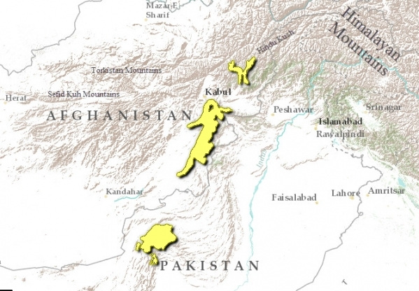
The East Afghan Montane Coniferous Forest spans from Eastern Hindu Kush at Jalalbad Valley, Kunar Range, and Ghazni Province in the north. In the south, it extends to lower Kohistan of Indus, Safed Koh, Takhat-i-Suleiman, and Koh-i-Maran ranges and Quetta Pass of western Pakistan.
The average precipitation is 200-400 millimeters (mm). Temperatures vary from -12 degrees Celcius (ºC) to 40 ºC. The soil in the north is made up of clay substrate covered with coarse gravel, small stones or rocks, and organic detritus. South, the ecoregion has a bedrock of sedimentary limestone, and soils on the flat lands are sandy loam. The Alingar and Kunar rivers in northeastern Afghanistan join the Kabul River and flow southeast into the Indus River of West Pakistan. Hashmat Khan, Sarobi, and Duronta are three lakes significant as staging areas for breeding waterfowl species that are situated in northeast Afghanistan and designated as Important Bird Areas by BirdLife International.
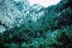
 Suleiman Range, Pakistan (Photograph by WWF/ Hartmut Jungius)
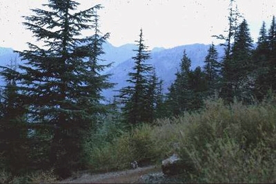
 Two types of forests make up this ecoregion because of the influence of the monsoon. Areas between 2,100 and 2,500 m receive less monsoon rain and have dry coniferous species. Pinaceae forest creates a belt between the Fagaceae and the Cedrus community. These include Pinus gerardiana and Quercus baloot species. The understory vegetation of this elevation includes Indigofera gerardiana, Sambucus ebulus, and Plecanthrus rugosus. As one moves to higher elevations (2,500-3,100 m) where there is a continuous rain from the monsoon, a temperate deciduous species mixes with the conifers. Picea smithiana, Pinus wallichiana, Quercus semecarpifolia, and Cedrus deodara develop into dense forest cover at this elevation with trees 15-30 m high. Cedrus deodara is one of the most important timber species in both Pakistan and Afghanistan. At 3,100-3,300 m the precipitation decreases and the cedar forest is replaced by junipers (Juniperus seravschanica). The dominant herbaceous ground vegetation at higher elevations is composed of hemicryptophytes such as Polygonum amplexicaule, Rumex nepalense, Fragaria nubicola, and Berberis spp. and geophytes such as Polygonatum geminiflorum, Lilium polyphyllum, and Habenaria aitchisonii.
Biodiversity Features
This ecoregion is a prime location for migrant bird species and breeding waterfowl. There are approximately 30,000 migratory birds in the northern part of this ecoregion alone, found mostly near lakes. Waterfowl species of this area include pochards, coots, moorhens, black-necked grebe, greater flamingos, spoonbills, shelducks, and marbled teals. The largest number of the highly threatened western tragopan (Tragopan melanocephalus) and long-billed bush-warbler (Bradypterus major) are found here. These birds have a specialized habitat need: pockets of pristine forests, which have been severely fragmented and thus led to their dwindling population. Brooks's leaf-warbler (Phylloscopus subvirdis), Kashmir nuthatch (Sitta cashmirensis), orange bullfinch (Pyrrhula aurantiaca), and Tytler's leaf-warbler (Phylloscopus tytleri) are some of the restricted-range species in the open coniferous and deciduous forest throughout the ecoregion. There are no endemic bird species.
Mammals such as Chiltan wild goat (Capra falconeri chiltanensis), Himalayan black bear (Ursus thibetanus langier), leopard cat (Prionailurus bengalensis), grey langur (Semnopithecus entellus), rhesus macaque (Macaca mulatta), jackal (Canis aureus), and red fox (Vulpes vulpes) are found throughout the ecoregion. Royle's high mountain voles (Alticola royeli), Afghan vole (Microtus afghans), marbled polecat (Vormela peregusna), and Euphrates jerboa (Allactaga euphratica) are found mainly in the northern part of this ecoregion. Other small mammals include two bat species (whiskered bat and grey long-eared bat), two squirrel species (giant red flying squirrel and Kashmir flying squirrel), and yellow throated marten, Turkestan rat, and long-tailed field mouse. The Chiltan wild goat is listed as critical, and the Himalayan bear, Kashmir flycatcher, and Himalayan musk deer are listed on the Red Data List as vulnerable. There are no endemic mammal species.
Current Status
Only 8 percent of the ecoregion is covered by the protected area systems (table 1). Hazar Ganji-Chiltan National Park has helped to recover the Chiltan markhor population, which was nearing extinction. In the 1950s the population of Chiltan markhor used to exceed 1,200. Studies in 1970 indicated that the number fell to less than 150. Since the area was designated as a park, this number has grown to about 300. A total area of 2.2 million ha (34 percent) of well-preserved coniferous forest located in Kunar, Paktia, and Nangarhar provinces of east and north Afghanistan are thinning. Some no longer produce sustainable products because of the widespread extraction of timber without any consideration for future environmental degradation. Of the three forest regions, Kunar Province has the highest diversity content and the biggest area.
Table 1. WCMC (1997) Protected Areas That Overlap with the Ecoregion.
| Protected Area | Area (km2) | IUCN Category |
| Surkhab | 40 | DE |
| Hazar Ganji-Chiltan | 620 | V |
| Wam | 100 | VI |
| Sasnamana | 60 | IV |
| Gogi | 80 | VI |
| Zawarkhan | 40 | UA |
| Total | 940 |
Types and Severity of Threats
One of the main threats of this area is logging of deodar, fir, blue pine, and oak to fulfill the ever-increasing demand for timber, fuel, and fodder. The abundant and dense forests of this ecoregion have been replaced by construction sites for industrial developments. Freshwater lakes and wetlands have been severely affected by irrigation channels. This has caused low water levels during the dry months, which disturb breeding birds. There are also introduced amphibian species such as a toad (Bufo virdis) and frogs of Rana spp. in the wetlands of northeast Afghanistan. The rivers and lakes have been polluted by domestic sewage, agricultural effluents, industrial waste, and garbage dumps. The use of chemical pesticides in irrigation channels has contributed to the decrease in the number of mammals such as jackals. Although the red fox is still widespread, it is ruthlessly hunted for its valuable pelt.
Justification of Ecoregion Delineation
We identified five [[ecoregion]s]-Sulaiman Range Alpine Meadows, South Iran Nubo-Sindian Desert and Semi-Desert, Baluchistan Xeric Woodlands, Rajasthan-North Pakistan Sandy Desert, and East Afghan Montane Coniferous Forests-from the Baluchistan subunit. All five of these ecoregions extend westward and have a portion of their ecoregion beyond the limits of this analysis. These ecoregions overlap with numerous Udvardy biogeographic provinces outside the scope of this analysis. These include the Hindu Kush highlands to the north and the Anatolian-Iranian Desert, Iranian Desert, and Caucaso-Iranian highlands to the south and west.
Additional Information on this Ecoregion
- For a shorter summary of this entry, see the WWF WildWorld profile of this ecoregion.
- To see the species that live in this ecoregion, including images and threat levels, see the WWF Wildfinder description of this ecoregion.
- World Wildlife Fund Homepage
| Disclaimer: This article is taken wholly from, or contains information that was originally published by, the World Wildlife Fund. Topic editors and authors for the Encyclopedia of Earth may have edited its content or added new information. The use of information from the World Wildlife Fund should not be construed as support for or endorsement by that organization for any new information added by EoE personnel, or for any editing of the original content. |


