Ecosystems and Human Well-Being: Volume 1: Current State and Trends: Regulation of Natural Hazards

This is Chapter 16 of the Millenium Ecosystem Assessment report Ecosystems and Human Well-Being: Volume 1: Current State and Trends
Coordinating Lead Author: Lelys Bravo de Guenni
Lead Authors: Manoel Cardoso, Johan Goldammer, George Hurtt, Luis Jose Mata
Contributing Authors: Kristie Ebi, Jo House, Juan Valdes
Review Editor: Richard Norgaard
Main Messages
Floods and fires are natural processes occurring in the biosphere that have affected the planet for millennia. As a result of human development and the growth of public and private wealth, these events are having increasing impacts in term of costs and benefits for ecological and human systems.
It is clear that extreme events result in differentiated impacts across ecological and human systems, including impacts on human well-being (such as economic condition, health, happiness, and so on). Different individuals and groups experience different costs and benefits at various spatial and temporal scales.
Under certain circumstances, ecosystem conditions may serve to alleviate the impacts of an extreme event on human systems. For example, the economic impacts of a particular flood event on a community depend largely on the amount of unoccupied floodplains available for flood waters.
Ecosystem conditions may increase or reduce both costs and benefits at various temporal and spatial scales. Examples of these services include sediment and nutrient deposition in floodplains and deltas and natural fire regimes that help to sustain and rejuvenate ecosystems through periodic burning.
Ecosystem conditions that serve to modulate the impacts of extreme events on human well-being have experienced various changes as a result of a variety of drivers that affect ecosystems. The relationships between drivers and their impacts on ecosystem services and extreme events on human well-being are varied and highly complex and are not well understood.
Our knowledge of how ecosystems ameliorate or accentuate the impacts of extreme events on human well-being is limited for a variety of reasons. First, in many parts of the world understanding of the frequency and magnitude of extreme events is not well developed. Second, the collection of trend data on the impacts of extreme events on human well-being has been uneven and the data are often of poor quality. Third, in those cases where good trend data exist they are typically focused on first-order economic impacts and ignore other measures related to human well-being. Fourth, few rigorous quantitative studies have been performed that properly analyze the various factors that explain temporal and spatial patterns of extreme events or trends in impacts. Fifth, very few studies have sought to identify and quantify the services provided by ecosystems in the context of regulation of extreme events such as floods and fires.
Available studies on extreme events, their impacts on human well-being, and the roles of ecosystem services do, however, allow several qualitative assertions to be made:
- Humans are increasingly occupying regions and localities that are exposed to extreme events, establishing settlements, for example, on coasts and floodplains, close to fuelwood plantations, and so on. These actions are exacerbating human vulnerability to extreme events. Many measures of human vulnerability show a general increase, due to growing poverty, mainly in developing countries.
- Impacts of natural hazards are increasing in many regions around the world. Annual economic losses from extreme events increased tenfold from the 1950s to 1990s. From 1992 to 2001, floods were the most frequent natural disaster (43% of the 2,257 disasters), and floods killed 96,507 people and affected more than 1.2 billion people over the decade. A large number of damaging floods occurred in Europe in the last decade. Material flood damage recorded in Europe in 2002 was higher than in any previous year.
- Human vulnerability is usually the primary factor that explains trends in impacts, and, in general, it overwhelms any positive effect on human well-being.
- Interactions of modern human activities with ecosystems have contributed to increasing human vulnerability and to the impact of extreme events on human well-being.
- Appropriate management of ecosystems can be an important tool to reduce vulnerability and can contribute to the reduction of negative impacts of extreme events on human well-being.
16.1 Introduction
The impacts of natural disasters have changed dramatically over the past 30 years. While the number of people reported affected by natural disasters increased from just over 700 million in the 1970s to nearly 2 billion in the 1990s, deaths from natural disasters fell from nearly 2 million in the 1970s to just under 800,000 in the 1990s. The reasons behind these statistics are complex and need further analysis. However, the drop in fatalities can be attributed in part to better disaster preparedness, although most deaths occur in developing countries, where disaster preparedness measures are less well developed.
This chapter examines the role of [[ecosystem]s] in the context of the impacts of floods and fires on human systems. Floods and fires are considered natural hazards—that is, natural processes or phenomena occurring in the biosphere that may become damaging for human as well as for natural systems. The outcome of a natural hazard becomes a natural disaster as the result of the interaction of human or ecosystem vulnerability and the extent and severity of the damage to the human group or ecosystem receiving it. Many other natural hazards exist that could have been included in the assessment, such as droughts, tropical cyclones, volcanic eruptions, and earthquakes, for example. Only floods and fires are considered here, however, because they are most strongly subject to feedback processes and most directly influenced by human activities such as urbanization and environmental degradation. Deforestation, for example, has a direct effect on the incidence and magnitude of flood events.
This chapter focuses on the roles that ecosystems play in modulating the effects of extreme events, and in particular in protecting human well-being from the impacts of floods and fire. Protection can be defined as contributing to the prevention of harm as well as to the receipt of benefits. It is well understood that extreme events result in differentiated impacts to human well-being, with resulting costs and benefits to people at different spatial and temporal scales (Pielke Jr. 2000a, 2000b). For example, the tropical cyclone that devastates a neighborhood is a disaster to those who lose their homes but also an opportunity for aquifer recharge, especially after a long drought period. In the context of flooding, the impacts of a particular event may be reduced by the presence of unoccupied floodplains that allow flood waters to pass through unpopulated areas. Benefits from flooding may occur through the transport of sediments and nutrients to the coastal zone, although the consequences of this are often negative.
It is of course important to recognize that natural events do not always bring benefits to human well-being; some may result in harms or costs. For example, flood conditions may foster the spread of disease or disease vectors harmful to humans, such as West Nile virus or hantavirus. Thus, understanding valuation of ecosystem services in the context of extreme events is complicated due to the interacting benefits and costs. Logically, if ecosystems play an intervening role between extreme events and human well-being, then ecosystem services must also provide differentiated impacts on humans.
Understanding the role of ecosystem services in protecting human well-being is further complicated by the diverse array of factors that contribute to protection of and harm to human well-being in the context of extreme events. Such impacts result from the effects of the extreme event itself as well as the vulnerability of human systems. Many of these effects can be considered independent of the intervening role of [[ecosystem]s], such as when a powerful tropical cyclone strikes a highly urbanized area. In this case, the economic losses are unavoidable, although human losses can be prevented or minimized.
Ecosystem conditions and their services can play a role in modulating both the event and the human systems that create conditions of vulnerability. This is also true for natural systems. As an example, a perennial grass from a Mediterranean ecosystem might become more vulnerable to extreme wildfires and rainfall events under severe erosion and land degradation conditions (De Luis et al. 2004). In the case of flooding, local or regional ecosystem conditions, such as increased deforestation, may contribute to the magnitude or scope of particular flooding events, setting the stage for increased vulnerability. Human vulnerability is conditioned by the characteristics of local ecosystems, social systems, and human modifications to them.
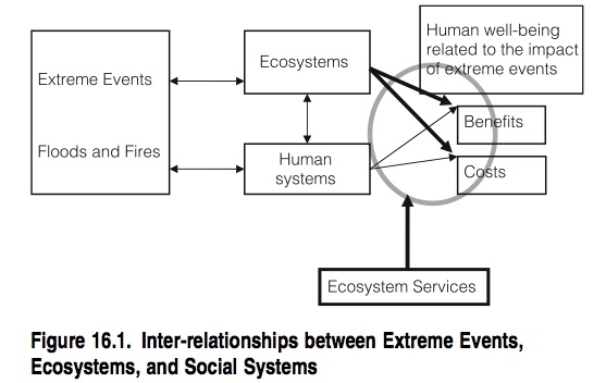
Figure 16.1 depicts in a highly simplified manner the various inter-relationships of extreme events, human and ecological systems, and the resulting effects (both benefits and costs) to human well-being. Highlighted in red is the role of ecosystem services in contributing to benefits and costs related to human well-being in the context of extreme events. The arrows represent the differentiated impacts of benefits and costs for both ecosystems and human systems. These impacts are modulated by the ecosystem regulating services.
|
Table 16.1. Key Role of Ecosystems in Regulating Extreme Events Ecosystem Role in Flood Regulation Role in Fire Regulation Cultivated crop cover provides flood protection, conditioned on good management part of the management of some cropping systems, e.g., sugar cane, timber, etc. Dryland protection through vegetation cover; recharge of aquifers biodiversity issues: adaptation mechanisms to fire Forest protection from floods providing flood attenuation and soil loss prevention part of the natural system; reducing wood fuel accumulation; biodiversity issues Urban move people away from flood-prone areas, conditioned on good urban planning move people away from natural fire-prone areas; scale benefits from more effective fire prevention and control Inland Waters provide mechanisms for flood attenuation potential (wetlands, lakes, etc.) wildfires control, e.g., pit fires control by wetlands Coastal benefits from sediment transport to the coastal zone; flood protection provided by coastal ecosystems (barrier beaches, mangroves, etc.) not applicable Marine benefits from nutrient transport to the oceans not applicable Polar discharge regulation to oceans in the Arctic system (freshwater provision to Arctic oceans) not applicable Mountains regulating flood-related events (slope stability) main source of wood fuel Islands benefits from sediment transport to oceans through floods from the mainland; aquifer recharge as main source of fresh water not applicable (Ecosystems and Human Well-Being: Volume 1: Current State and Trends: Regulation of Natural Hazards) |
16.1.1 Ecosystem Services in the Context of Regulation of Extreme Events
This section describes the mechanisms by which [[ecosystem]s] regulate floods and fires, producing benefits to both ecosystems and humans. Table 16.1 describes the mechanisms by which main ecosystems regulate natural hazards.
These mechanisms the role of natural hazards in preserving biodiversity patterns and key biophysical processes in the biosphere (Wohlgemuth et al. 2002). These natural phenomena play an important role in the natural cycle of matter and energy. Fires, for example, are part of the natural behavior of the biosphere, and floods are an efficient mechanism for natural transport of dissolved or suspended material (Pielke Jr. 2000b).
In the case of humans, ecosystem regulation can provide protection from the adverse consequences of natural hazards to human well-being.
16.1.1.1 The Role of Wetlands, Floodplains, and Coastal Ecosystems in the Regulation of Floods
The preservation of natural areas is important for flood attenuation. For example, some natural soils (not affected by human activities) have a large capacity to store water, facilitate transfer of groundwater, and prevent or reduce flooding. The capacity to hold water is dependent on soil texture (size of soil particles and spaces between them) and soil structure (nature and origin of aggregates and pores). For instance, clay soils have a larger capacity to hold water than sandy soils due to pore size.
Other intact areas, such as barrier beaches, offer natural flood protection. Important inland water components, such as wetlands and lakes, are key agents of flood attenuation through energy dissipation of runoff peaks. Gosselink et al. (1981) determined that the forested riparian wetlands adjacent to the Mississippi in the United States during pre-settlement times had the capacity to store about 60 days of river discharge. With the subsequent removal of wetlands through canalization, leveeing, and drainage, the remaining wetlands have a current storage capacity of less than 12 days discharge—an 80% reduction of flood storage capacity. The extensive loss of these wetlands was an important factor contributing to the severity and damage of the 1993 flood in the Mississippi Basin, the most severe flooding in recent U.S. history (Daily et al. 1997). Similarly, the floodplain of the Bassee River in France performs a natural service by providing an overflow area when the Seine River floods upstream of Paris. A valuation analysis that highlights the economic need to conserve this natural environment is presented by Laurans (2001).
Wetlands, however, should not be viewed as single units; when examined collectively on a catchment scale, they are all interlinked. Although an isolated wetland may perform a significant flood control function, effective control is more often the result of the combined effect of a series of wetlands within a particular catchment area (Verry and Boelter 1978). Thus, when considered singly, upstream wetlands may appear to have an insignificant effect on flood attenuation. Although upstream wetlands are often numerous, and their cumulative effect may be considerable, most flood control benefits of wetlands are derived from floodplain wetlands (Bullock and Acreman 2003).
Coastal areas, including coastal barrier islands, coastal wetlands (Wetland classifications), coastal rivers floodplains, and coastal vegetation, all play an important role in reducing the impacts of floodwaters produced by coastal storm events and have been characterized by Leatherman et al. (1995) as a ‘‘movable boundary’’ that continuously responds to fluvial and deltaic fluxes.
Storm regulation in the coastal zone can be achieved by preserving natural buffers such as coral reefs, mangrove forests, sandbars, and so on. When such buffers have been destroyed, management agencies will sometimes try to restore damaged habitats or construct artificial wetlands.
16.1.1.2 The Role of Ecosystems in Regulating Fires
Fire regulation is defined here as the capacity of [[ecosystem]s] to maintain natural fire frequency and intensity. Fires occur due to a combination of fuel, flammability, ignition, and spread conditions, which are generally related to climate and land cover. For example, precipitation is closely related to fuel load and flammability. Persistent high precipitation allows for increases in fuel by favoring vegetation growth, but leads to conditions that may be too wet to allow fires. Persistent low precipitation, on the other hand, limits plant growth and fuel supply. High temperature and wind speed generally enhance flammability and fire spread. High flammability combined with high fuel load increase the likelihood of intense fires. Temperate regions suffer from catastrophic fires after periods of fuel buildup, whereas tropical forests can store large amounts of fuel, but humid conditions naturally prevent flammability.
In addition to climate and land cover, factors related to economy, education, and technology are also important for fire regulation. For example, economic and educational conditions that determine the use of agricultural techniques other than fires may reduce accidental fires (Nepstad et al. 1999a). Fire regulation can also benefit from investments in systems for monitoring (Environmental monitoring and assessment) fire risk and activity (Prins et al. 1998) and from disaster-relief mechanisms in cases of catastrophic fires (FEMA 2004). In these cases, one of the most important tools for regulating fires is the use of satellite data.
Remote sensing data can provide fire occurrence information, help improve preparedness, and aid decision-making on fire regulation (Dwyer et al. 2000; Justice et al. 2003; Grégoire et al. 2003). These data are usually reported as ‘‘fire pixels’’ on satellite maps where active burning is highlighted. Several satellite-based systems are in use to monitor fire activity (e.g., Setzer and Malingreau 1996; Prins et al. 1998; Giglio et al. 2000; Justice et al. 2002). For example, the Moderate Resolution Imaging Spectroradiometer (MODIS) Fire Products reports fire activity globally at spatial resolutions as small as 1 kilometer square and temporal resolutions of up to four times per day. (See Figure 16.2 in Appendix A.)
Satellites can also provide information on recent patterns of the area affected by fires, based on comparisons between repeated images. For example, GBA2000 (Grégoire et al. 2003) and GLOBSCAR (Global Burn Scars) (Kempeneers et al. 2002) are inventories of the area burned worldwide in 2000.
When analyzing fire patterns from remote sensing, it is important to consider that some factors can interfere with fire detection. For example, fires occurring at different times to the detection times (Ichoku et al. 2003) or under clouds or forest canopies may not be detected and hence under-recorded (Setzer and Malingreau 1996); exposed soils and solar reflections may be misinterpreted as fires (Giglio et al. 1999); and low spatial resolution can impair the identification of small burned areas (Simon 2002).
Thus to properly interpret satellite fire patterns and improve detection algorithms, comparisons between satellite- and fieldbased fire data (ground-truthing) are essential. While more studies are needed, there are indications that satellites tend to report fewer active fires than actually occur on the ground and that frequent (sub-daily) temporal sampling is as important as high spatial resolution.
16.1.2 Hazard Regulation and Biodiversity
It is increasingly accepted that a large pool of species is required to sustain the structure and functioning of ecosystems, especially in landscapes with intensive land use. In this context, a group of related hypotheses (Loreau et al. 2001) proposes that biodiversity may act as an insurance or buffer against changing environmental conditions. However, the suggestion that biodiversity controls ecosystem processes, including stability, needs to be analyzed in a much wider array of conditions, since not all ecosystems respond equally to environmental disturbance and since some perturbations may be better buffered by biodiversity than others (Roy 2001).
In the face of major natural disturbances such as fire and flood and an increased probability of their occurrence due to global change, the buffering capacity attributed to biodiversity may play a key factor in ecosystem recovery. The existence of a minimum species richness could help ensure the presence of species or functional groups with dominant roles in biomass production and regulation of nutrient fluxes. (See also Chapters 11 (Ecosystems and Human Well-Being: Volume 1: Current State and Trends: Regulation of Natural Hazards)and 12 (Ecosystems and Human Well-Being: Volume 1: Current State and Trends: Regulation of Natural Hazards).) A number of observations suggest that after a disturbance or when environmental conditions change, biodiversity richness at larger spatial scales, such as landscapes and regions, can ensure that appropriate key species for ecosystem functioning are recruited to local systems. (See also Chapter 4 (Ecosystems and Human Well-Being: Volume 1: Current State and Trends: Regulation of Natural Hazards).)
The importance of natural disturbance processes in the maintenance of landscape diversity has been documented for many protected areas of the world. An example of this is the effect of fires in Yellowstone National Park. In 1988, fires burned a total of 45% (400,000 ha) of the park (Christensen et al. 1989). Reconstructions of the history of fires in Yellowstone suggest that the last time a fire of this magnitude occurred was in the early 1600s. Although plant species richness was still increasing at the scale of sampling plots (less than 10 square meters) five years after the 1988 fires, overall species richness at the landscape level had been unaffected by fires. However, relative abundance varied among species (Turner et al. 1997).
Large-scale disturbance are very important in structuring ecosystems. Changes in this disturbance regime—for example, as a result of climate change—could have substantial implications from the ecological point of view (Turner et al. 1997).
The role of biological diversity in providing insurance, flexibility, and risk distribution across various scales within the context of ecosystem resilience and under conditions of uncertainty is discussed in Chapter 4.
16.2 Magnitude, Distribution, and Changes in the Regulation of Natural Hazards
This section presents the ecosystem components and mechanisms that provide regulating services for floods and fires and their magnitude, distribution, and variability. First we describe key ecosystem components providing regulation of floods and fires at a global scale. Then we present evidence of the historical changes that have occurred in the capacity of [[ecosystem]s] to provide flood and fire regulation. Changes in the occurrence and magnitude of these natural hazards and their impacts on human well-being provide an indirect measure of the ability of ecosystem conditions to provide regulation services. Unfortunately, data on the direct relationship between the magnitude (frequency and intensity) of natural hazards and changes in the ecosystem conditions as a direct consequence of anthropogenic actions are practically non-existent. Therefore, incidence and trends in natural hazard impacts on ecological and social systems are used as proxy measures of the regulation capacity of ecosystems.
16.2.1 Ecosystem Conditions That Provide Regulatory Services
16.2.1.1 Flood Regulation
Wetlands, floodplains, lakes, and reservoirs are the main providers of flood attenuation potential in the inland water system. Geographic distribution of wetlands is described in different databases (such as Matthews from GISS, University of Kassel, and Ramsar). The University of Kassel in Germany has developed a map of the global distribution of wetlands, lakes, and reservoirs. (See Figure 20.1 in Chapter 20 (Ecosystems and Human Well-Being: Volume 1: Current State and Trends: Regulation of Natural Hazards).) Wetlands cover an estimated 6.6% of the global land area (excluding Antarctica and Greenland), and lakes and reservoirs alone cover 2.1% (Lehner and Döll 2004).
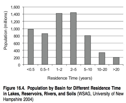
Flood attenuation potential can be estimated by the ‘‘residence time’’ of rivers, reservoirs, and soils. (See Figure 16.3 in Appendix A.) Residence time is defined as the time taken for water falling as precipitation to pass through a system. The longer the residence time, the larger the buffering capacity to attenuate peak flood events. Larger rivers, such as the Congo and the Amazon, have a greater attenuation capacity than smaller rivers. Data for populations living in different zones of water residence time are presented in Figure 16.4. Nearly 2 billion people live in areas with a residence time of one year or less and are thus located in areas of high flood risk with low attenuation potential. Most of these people live in northern South America, highly populated regions of northern India and South East Asia, Central Europe, and the Southwest coast of Africa.
16.2.1.2 Fire Regulation
Several ecosystem conditions are related to fire regulation— principally the amount of vegetation (Land-cover), and therefore fuel, in the system. Climate, land cover, and land use are important factors linked to these conditions. Climate variability is a dominant factor affecting large wildfires in the western United States, although current fire management practices focus on reducing fuel availability (McKenzie et al. 2004). Regions with climates that present distinct dry and wet seasons have potentially more fires. Under these climates, vegetation growth during the wet season can increase fuel load, and flammable conditions during the dry season can lead to more frequent and intense fires. In addition to seasonality in precipitation, temperature and wind speed are important. Hot conditions and intense winds may promote high fire frequency and intensity by favoring fuel dryness and fire spread.
Land cover and land use are important because they can affect fuel load, flammability, number of ignition events, and spread conditions. For example, forests with deep root systems may take longer to become flammable during dry periods than vegetation with shallow roots. Soils that have low water-holding capacity may lead to flammable conditions after short dry periods. Fire suppression reduces sources of ignition but may favor fuel buildup and the likelihood of more intense fires when they do occur. Land use practices such as pasture maintenance can lead to higher number of trigger events, but the use of firebreaks can help to lower the spread of fire.
16.2.2 Impacts of Ecosystem Changes on Underlying Capacity to Provide a Regulating Service
Direct quantification of the underlying capacity of ecosystems to regulate floods and fires is difficult, and few studies have sought to identify and quantify changes in these regulating services. This section looks at the direct consequences of a reduced capacity to regulate floods and fires, therefore, and presents evidence for changes in flood incidence and flood-related damages as well as changes in fire activity.
16.2.2.1 Evidence for Changes in Flood Incidence and Flood-related Damages
A damaging flood is defined as a flood in which individuals or societies suffer losses related to the event. In almost all cases a damaging flood results from a combination of physical and societal processes (Pielke Jr. 2000b). All types of floods, such as riverine or coastal floods, sudden snow melt floods, or floods after heavy, intense rainfall, have become more destructive in recent years (IFRC 2001). Moreover, projections show that this tendency is likely to become even more pronounced in the future. From 1950 to 1990, annual economic losses from extremes events increased steadily (Swiss Re 2003), largely due to several indirect socioeconomic drivers, including population increase and accumulation of wealth in vulnerable areas, and to some extent direct drivers, such as climate and climate change.
Hydrological variables (precipitation and stream flow, for example) show strong spatial and temporal variability. Occasionally, they take on extremely high values (heavy precipitation occurs, perhaps), with substantial impacts on ecosystems and human society. Thus floods have been a major issue since the beginning of civilization (floods of the Tigris and Euphrates were documented in ancient Babylonian and Sumerian texts, for instance) and continue to be so.
According to data compiled by the International Red Cross (IFRC 2001), floods account for over two thirds of the average of 211 million people a year affected by natural disasters. Every year extreme weather and climate events cause significant morbidity and mortality worldwide. From 1992 to 2001, floods were the most frequent natural disaster (43% of the 2,257 recorded disasters), killing 96,507 people and affecting more than 1.2 billion people (OFDA/CRED 2002). In the Americas, floods accounted for 45% of all deaths from disasters (IFRC 2003). Table 16.2 presents the total number of deaths due to floods and wild fires, by continent, during 1990–99. Asia is the most affected continent in terms of human-related flood losses.
|
Table 16.2. Deaths Due to Floods and Wild Fires, by Continent, 1990–99 (IRFC World Disaster Report 2001) Phenomenon Oceania United States and Canada Rest of Americas Europe Africa Asia Total Floods 30 363 35,235 2,839 9,487 55,916 103,870 Wild Fires 8 41 60 127 79 260 575 In 2003, flood events did not occur to the same extent as they had in (northern) summer 2002; rather, heat waves dominated, especially in Europe. However, a Swiss Reinsurance Company study found that economic losses from ‘‘catastrophes’’ in 2003 were on the order of $70 billion (Swiss Re 2003). Natural disasters, including floods, accounted for $58 billion. Swiss Re also estimated that ‘‘natural and human disasters’’ claimed 60,000 human lives in 2003. Another study put economic losses at $60 billion and deaths due to extreme events at 75,000 (Munich Re 2003). Significant floods did occur in Nepal, France, Pakistan, and China during the (northern) summer of 2003 (Munich Re 2003). The majority of large floods have occurred in Asia during the last few decades, but few countries have been free of damaging floods. In many countries at least one destructive flood (including storm surges) has occurred since 1990 (Kundzewicz and Schellnhuber 2004). Pielke and Downton (2000) found an annual increase of 2.93% in the total flood damage in the United States over the period 1932–97. This increase has been attributed to both climate factors, such as increasing precipitation, and socioeconomic factors, such as increasing population and wealth. Many damaging floods have also occurred in Europe in the last decade. Material damage in 2002 was higher than in any previous year. For instance, the floods in Central Europe in August 2002 caused damage totaling nearly 15 billion euros (Kundzewicz and Schellnhuber 2004). Several destructive floods also occurred in other parts of the world in 2002, including China, Russia, and Venezuela (Ecosystems and Human Well-Being: Volume 1: Current State and Trends: Regulation of Natural Hazards) . An evaluation of the damages, by affected area, is presented in Table 16.3.
During the 1960s and 1970s, more than 90% of natural disasters in the United States were the result of climate extremes (Changnon and Easterling 2000), and it has been estimated that about 17% of all the urban land in the United States is located within the 100-year (the return period) flood zone (Pielke and Downton 2000). Likewise, in Japan, about 50% of the population and 70% of infrastructure are located on floodplains, which account for only 10% of the land area. On the other hand, in Bangladesh the percentage of flood-prone areas is much higher, and inundation of more than half of the country is not uncommon. For instance, about two thirds of the country was inundated in the 1998 flood (Mirza 2003). 16.2.2.2 Evidence for Changes in Fire Activity It is difficult to make a complete assessment of the changes in global fire activity because of the diverse methodologies employed and the limited availability of data. At large scales, recent fire activity patterns (during the last 10 years) based on remote sensing data from the satellites are relatively well known (Dwyer et al. 2000; Justice et al. 2002). Data at the local scale are less common and generally only available for specific regions where fire occurrence has been documented from ground-based observations (Schelhaas and Schuck 2002; NIFC 2004). In some cases, these records cover many years (10 to 100) and extend our knowledge on fire patterns further into the past. Tree rings have also been used in the analysis of forest fires for the last few centuries. For longer time scales, fire patterns have been determined from analyses of plant materials in sediments (Clark 1997), which can provide evidence of fires that occurred hundreds to millions of years ago. Active fire detections from satellite data made from April 1992 to March 1993 showed that most fire activity occurs from July to August and from November to January (Dwyer et al. 2000). Seventy percent of the detected fires were located in the tropics, with 50% of all fires in Africa. Globally, fires affected 19% of savanna areas, 20% of broadleaf forests, 20% of crops and pasture areas, 4% of shrublands, and 4% of grassland areas (Dwyer et al. 2000). Information on the global area burned in 2000 is available from two satellite-based inventories: the GBA2000 (Gre´goire et al. 2003) and the GLOBSCAR (Kempeneers et al. 2002). Based on GBA2000, fires affected ~350 X 106 ha in 2000; 81% of this area occurred in woodlands and scrublands, 16.5% in grasslands and croplands, 1.5% in coniferous and mixed forests, and 1.2% in broadleaf forests (Bartholomé et al. 2003). Most of the fire activity occurred from July to September and from December to January. Figure 16.6 (in Appendix A) illustrates the global pattern of burned areas based on GBA2000. According to GLOBSCAR, the global burned area in 2000 was ≈200 X 106 ha (Kempeneers et al. 2002). Of this total, 59% was located in Africa, 11% in Asia, 9% in Australia, 8% in Europe, 7% in South America, and 6% in North America. Most of the fires occurred during June-August and November-January. Despite the potential to provide large-scale information, satellite-based global fire data sets covering long periods of time are rare (Lepers 2003). However, for tropical regions data on major fires from January 1997 to December 2000 are available from the ATSR World Fire Atlas Project. Based on these data, Lepers (2003) determined that 36% of exceptional or frequent fire events occurred in South America, followed by Africa (30%) and Asia (20%), mostly during El Ni ño conditions. In Asia and in Central and South America, these fires appear to be associated with areas experiencing deforestation and forest degradation (Lepers 2003). (See Figure 16.7 in Appendix A.) Independent studies have also shown that high fire activity in tropical regions can be driven by changes in land use. For example, higher fire activity was related to conversion of peat swamp forests in Indonesia (Page et al. 2002). In Amazonia, large-scale fire patterns mirror large-scale patterns of deforestation (Skole and Tucker 1993), road construction (Prins et al. 1998; Laurence et al. 2001; Cardoso et al. 2003), and logging activities (Cochrane et al. 1999a; Nepstad et al. 1999). Consequently, increases in fire activity are likely to occur in response to future development programs in these regions, if the current relationships between fire and land use continue to hold (Cardoso et al. 2003). At the local scale, important data sets on fire patterns include inventories of areas burned. These data are commonly reported as aggregated state/country statistics. For example, fires in the United States burned an average of 4.1 million hectares a year from 1960 to 2002 (NIFC 2004). In Europe, from 1961 to 1999 forest fires and other woodland burned an average of nearly 450,000 hectares annually (Schelhaas and Schuck 2002). Forest fires in Australia affected on average 360,000 hectares a year from 1956 to 1971 and 480,000 hectares from 1983 to 1996 (Gill and Moore 2002). These are annual averages, but there is significant variability between years. Differences in methodologies and data availability make it difficult to compare figures from different regions and time periods. Yet the trends in these data sets are informative. For example, records available for extended periods show a general long-term reduction in the area burned. In the United States, the area burned has declined by more than 90% since 1930 (Hurtt et al. 2002) and in Sweden, the area burned fell from ~12,000 to ~400 hectares a year between 1876 and 1989 (Pyne and Goldammer 1997). In both countries, fires were reduced due to changes in land use. In Europe as a whole, however, the total extent and the interannual variability of the area of burnt forest are higher for the period 1975–2000 than for the 1960s, due, it is presumed, to changes in land use and climate (Schelhaas and Schuck 2002). 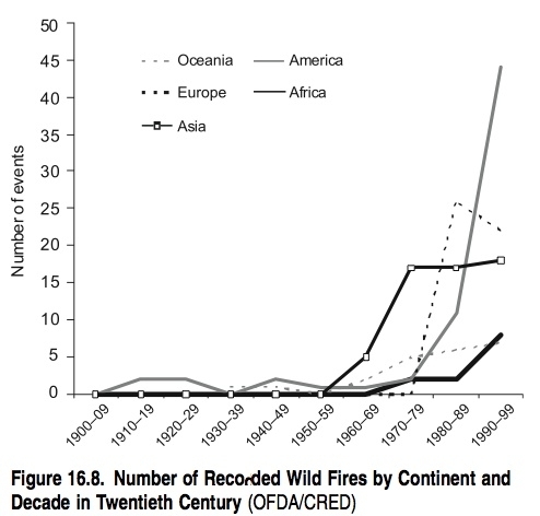 Data on major fire events from OFDA/CRED indicate a global increase in the number of major fire events after 1960. (See Figure 16.8.) According to CRED, changes were greatest in North America, where the number of major fires increased from ~10 during the 1980s to ~45 during the 1990s. CRED data sets only include data on major disasters (as defined by OFDA/CRED 2002) and are compiled from several sources, including U.N. agencies, nongovernmental organizations, insurance companies, research institutes, and press agencies. Evidence of past fire activity is provided by sediment analyses. Indicators include materials directly affected by or the products of fires, such as charcoal (Sanford et al. 1985), or materials such as pollen that can be used to determine the presence of specific plant species associated with fire regimes (Camill et al. 2003). Data from sediment records are especially important in providing long-term trends in fire activity at large scales. For example, data from sea sediments show that sub-Saharan Africa had low fire activity until about 400,000 years ago and indicate that humans had a significant influence on the occurrence of fire in the Holocene (Bird and Cali 1998). Analyzes from lake sediments show that natural fires have influenced forests in Amazonia for the last 7,000 years, including impacts on current patterns of forest structure (Turcq et al 1998). Data from soils also show that fires have disturbed lowland forests in the Amazonian region for the past 6,000 years (Sanford et al. 1985). In Minnesota, fires have been shown to result from shifts in vegetation caused by climate changes during the Holocene (Camill et al. 2003). An important common result from these studies is the link between high fire activity, dry climates, and fuel accumulation. 16.3 Causes of Changes in the Regulation of Floods and Fires The complex relationships between direct and indirect drivers are the main causes of change in the regulation of all natural hazards, including floods and fires. Understanding the patterns of distribution of such drivers may be partially achieved by describing which ecosystems are undergoing the most rapid and largest transformations. Such areas are likely to have the most reduced capacity to regulate natural hazards. Increased attention has been paid to extreme weather and climate events over the past few years due to increasing losses associated with them. For a more accurate understanding of weather impacts, however, it is necessary to acknowledge the actual and potential impacts of changes in both climate and society (Pielke Jr. et al. 2003). For instance, there are examples where economic impacts of hurricanes have increased dramatically during prolonged periods of rather benign hurricane activity (Pielke and Landsea 1998), and it is thought that a major factor conditioning hurricane losses in the United States is the significant increase in wealth and population in the coastal areas (Landsea et al. 1999). Human occupancy of the floodplains and the presence of floodwaters produce losses to individuals and society. Different pressures have caused increases in population density in floodprone areas, especially poverty, which has been responsible for the growth of informal settlements in susceptible areas around megacities in many developing countries. An immediate question that emerges from the increases in flood damage is the extent to which a rise in flood hazard and vulnerability can be linked to climate variability and change. This has been treated extensively in the Third Assessment Report of the Intergovernmental Panel on Climate Change and recently reviewed by Kundzewicz and Schellnhuber (2004). However, climate change is just one of the many drivers affecting the regulation of floods. A more detailed discussion about drivers affecting flood regulation is given in the next section. Changes in fire regulation can affect many other ecosystem services—supporting, provisioning, regulating, and cultural services. Supporting services affected by changes in the fire regulation capacity of ecosystems include nutrient cycling (for example, through fluxes and changing stocks of carbon (Carbon cycle) and nitrogen (Nitrogen cycle)) and primary production (a decrease due to vegetation removal, for instance, or increase by soil fertilization). Provisioning services affected include food production (increased by short-term fertilization, decreased through long-term nutrient losses) and availability of genetic resources (decreased by removal of flora and fauna). Regulating services affected include climate (changes in surface albedo and greenhouse gas emissions) and disease regulation (increase in the likelihood of respiratory diseases due to reduction of air quality). Finally, cultural services affected include recreation opportunities and aesthetic experiences (short-term effects on the landscape in protected areas, for example, or airport closings due to reduced visibility caused by smoke). 16.3.1 Drivers Affecting the Regulation of Floods In the MA framework a driver is defined as any natural or human-induced factor that directly or indirectly causes a change in an ecosystem, affecting its capacity to provide a service. Evidently, climate variability, climate change, and natural or anthropogenic land cover changes constitute physical and biological factors that directly affect the regulation of floods in terms of both processes and magnitude through changes in extreme rainfall events and peak runoff magnitude. If extreme events become more frequent and intense, the capacity of the system to provide the regulation could be affected. However, the distribution of the impacts of extreme events is not uniform across the world; their impact is greater in poorer and more vulnerable regions. Precipitation is a critical factor in causing floods, and its characteristics— such as intensity, location, and frequency—appear to be changing. During the twentieth century precipitation increased by 0.5–1.0% per decade in many areas in the mid- and high latitudes of the Northern Hemisphere (IPCC 2001). Moreover, increases in intense precipitation have been reported even in regions where total precipitation has decreased (Kabat et al. 2002). It is difficult to generalize, however, as some regions have shown decreases in both total and intensity of precipitation. Although intense rainfall is a sufficient condition to increase flood hazard, there are a number of other nonclimatic factors that exacerbate flood hazard (Kundzewicz and Schellnhuber 2004). A conceptual framework for understanding the human- and human-influenced processes contributing to damaging floods is presented in Figure 16.9. The broad integrative framework presented by Pielke and Downton (2000) may be used to understand the role of the drivers (direct or indirect) and policies in determining actual and potential flood outcomes. 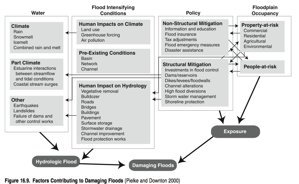 Lepers (2003) presented the most rapidly changing areas in terms of deforestation and forest degradation, which are predominately in the tropics. Nearly half of the affected forests are in South America, with 26% in Asia and 12% in Africa. Concurrently, the tropical regions of these three continents have had higher flood incidence and higher relative vulnerability (people killed per million exposed per year) (UNDP 2004). Figure 16.10 (in Appendix A) shows the number of floods between 1980 and 2000 (OFDA/CRED data set), together with the area of deforestation and forest degradation during the same period. Since there were multiple data sets used to describe deforested areas, the map indicates the number of data sets where deforestation was effectively identified (see Lepers 2003 for more details). The number of flood events is reported as total number of floods by country during the period 1980–2000. Tropical regions, mainly in Asia and South America, have been severely affected by floods and suffered an important loss in forest area and increasing forest degradation, as shown in Figure 16.10. There are also physical, biological, and anthropogenic factors that influence the regulation of floods, such as land use change and human encroachment of natural areas, such as wetlands, forest, and vegetation in [[coastal zone]s]. These perturbations of natural areas with the subsequent reduction of ecosystem functions affect flood attenuation potential and soil water storage capacity. It is clear that land conversion, deforestation, and loss of ecosystems such as wetlands have increased in the last decades (see Chapters 20 (Ecosystems and Human Well-Being: Volume 1: Current State and Trends: Regulation of Natural Hazards), 21 (Ecosystems and Human Well-Being: Volume 1: Current State and Trends: Regulation of Natural Hazards), and 28 (Ecosystems and Human Well-Being: Volume 1: Current State and Trends: Regulation of Natural Hazards)), but the impact of these drivers is unevenly distributed across different regions. Water extraction and diversion also constitute a direct anthropogenic driver that affects regulation of floods. The indirect drivers that strongly influence the regulation of floods are population growth, the level of economic, scientific, and technological development, a lack of governance, and population settlement preferences. Impacts vary between countries but are manifest in changes in exposure of human populations to extreme events, in the increase or decrease of GDP (depending on the region), in the capacity of governments to respond to flood-related disasters, and in the commercial and recreational activities developed along major river floodplains. The impacts are more intensely felt in densely populated areas in poorer countries, where farming activities, property, and commercial activities are most at risk. 16.3.2 Drivers Affecting the Regulation of Fires Direct and indirect drivers can change the capacity of ecosystems to provide fire regulation. For example, climate change is a natural and direct driver that can significantly affect fire regulation. Changes in precipitation variability may affect fire frequency and intensity. Low precipitation is associated with low fire frequency and intensity due to low biomass and fuel conditions. Similarly, high precipitation is associated with low fire frequency and intensity due to extremely wet conditions (Cardoso and Hurtt 2000). Regions with climates that present distinct dry and wet seasons have potentially more fires. Under these climates, fuel load can increase through vegetation growth during the wet season and the high flammability during the dry season, leading to more frequent and intense fires. In addition to varying precipitation patterns, hotter conditions and more intense [[wind]s] may promote a higher frequency and intensity of fires by favoring fuel dryness and fire spread. Climate effects may also depend on the state of the ecosystem. Forest trees with deep root systems may resist reduced precipitation longer before becoming flammable compared with trees with shallower roots, such as savannas species (Nepstad et al. 1994). And ecosystems with soils that have low water-holding capacity may become flammable after even short dry periods. Unfortunately, it is not easy to predict future climate conditions. Although there is evidence that the global average temperature is increasing (IPCC 2001), other climatic data, particularly at a regional, sub-continental scale, are less clear. Land use and land cover are important direct anthropogenic drivers of fire regulation. Included here are land management, land clearance and agriculture, housing development, logging, harvesting and reforestation, and fire suppression schemes. These can change fuel load, flammability, number of ignition events, and spread conditions. For example, fire suppression seeks to reduce the sources of ignition and short-term fire activity. However, long-term fire suppression may lead to high fuel loads and increase the likelihood of catastrophic fires, as demonstrated in the United States. Fire suppression also leads to lower trigger events, but intentional and accidental fires related to land management lead to a higher number of trigger events. Firebreaks lower spread, but actions that provide fire corridors (such as reforestation) may increase fire spread. Logging and harvesting may reduce fuel loads if biomass is completely removed or may increase fuel loads when biomass debris is left. Changes in land use and land cover have increased in developing regions in the tropics, leading to more fires (Page et al. 2002). In other regions, such as North America, however, land management has reduced fire frequency but increased fuel loads and the likelihood of more intense fires (Hurtt et al. 2002). Indirect drivers of fire regulation are mainly linked to human activities. These drivers include demographic, economic, sociopolitical, and scientific and technological drivers. (See Chapter 3 (Ecosystems and Human Well-Being: Volume 1: Current State and Trends: Regulation of Natural Hazards).) Demographic factors such as changes in population distribution may lead to different land use and land cover patterns, which are direct drivers of fire regulation. Changes in population may also alter property exposure to fire. Increase of population in fire-prone areas can potentially lead to higher exposure to fires, to increased risk of accidental fires, and to economic and human losses that are generally related to the level of preparedness for extreme events in the affected region. The degree of economic development is also important. Higher levels of economic development (Economic, social, and environmental elements of development) generally improve fire regulation. For example, access to machines and technology, such as tractors, offers an alternative to the use of fires as a land clearance tool for land management. Educational programs on fire risks and effects and to alternatives to the use of fire as a land use management tool also tend to improve fire regulation. In addition, higher levels of economic development allow for the use of fire risk and activity monitoring systems and for the development of programs for disaster relief in case of extreme events. Sociopolitical drivers, such as environmental policy, aid in fire regulation through many processes, including development of legislation and mechanisms of law enforcement and fire research, which leads to better knowledge of fires and how to fight them Scientific and technological drivers, such as the monitoring of fire activity, also enhance fire regulation by providing tools that help forecast and track fire activity. Satellite-based data collection systems, for example, provide additional information on fire frequency and behavior, as well as fire times and position. These can help support decisions on fire regulation resources, can improve law enforcement, and can contribute to fire research. 16.4 Consequences for Human Well-being of Changes in the Regulation of Natural Hazards In this section the consequences and impacts of extreme events on several aspects of human well-being are presented. These impacts result from the reduced capacity of ecosystems to regulate the magnitude and intensity of these events and from the ability of ecosystems and human populations to cope with the consequences of such events—their exposure, sensitivity, and resilience. The latter are all components of ‘‘vulnerability,’’ which is a complex and multidimensional concept, intrinsic to ecological and social systems. The degree of vulnerability of an ecosystem or human group will define the impacts of extreme events on society and ecosystems. Vulnerability is discussed extensively in Chapter 6 (Ecosystems and Human Well-Being: Volume 1: Current State and Trends: Regulation of Natural Hazards). In this section the vulnerability concept is treated as a tool to understand the differentiated impacts of extreme events on different societal groups. 16.4.1 Security and the Threat of Floods and Fires 16.4.1.1 Floods Many factors are likely to contribute to the increase of those affected by disasters. One of these is the vulnerability profile of the population. As more people move into urban areas and slum settlements they are increasingly living in susceptible (disaster-prone) regions. Migrants to big cities are normally at greatest risk, since they occupy the most hazard-prone locations on unstable slopes and flood-prone areas. However, urbanization is not necessarily a factor increasing disaster risk if it is managed in an appropriate and adequate way. Local authorities and their interactions with public, private, and civil society may play an important role in urban risk reduction to bridge the gap between national and international risk management players and local communities (UNDP 2004). But this implies a high level of municipal governance. Environmental degradation increases the negative effects of extreme events on society. While disaster preparedness measures do help save lives, the failure to reduce risks more broadly may be contributing to the higher numbers of disaster-affected people. Unfortunately, data are not uniformly collected, but more information would likely show an increase in the number of affected people, although the definition of ‘‘affected’’ varies (IFRC 2003). 16.4.1.2 Fires The detrimental impacts and consequences of some wildfires on economies, human health, and safety are comparable in severity to other major natural hazards. Unlike the majority of the geological and hydro-meteorological hazards, however, vegetation fires represent a natural and human-caused hazard that can be predicted, controlled, and, in many cases, prevented through the application of appropriate policies. Most countries already have laws, regulations, and action plans for management of forest fires and response procedures in place. These are often insufficient, however, or inadequately implemented. Loss estimates have been used to quantify the impacts of fires on society. Globally, such losses are difficult to quantify, but data do exist from areas where fire occurrence is well documented. For example, U.S. federal agencies spent an average of $768 million a year in fire suppression between 1994 and 2002 (NIFC 2004). From 1995 to 1999, the annual costs of prescribed fires increased from $20 million to $99 million (NIFC 2004). In 2003, fires in California burned over 750,000 hectares, caused 24 fatalities, and destroyed over 3,000 residences (FEMA 2004). An analysis of national fire policies concluded that mitigation policies were generally weak, rarely based on reliable data of forest fire extent, causes, or risks, and did not involve landowners most likely to be affected (ECE/FAO 1998). Furthermore, they were sometimes the result of ill-conceived forest management policies, particularly policies aimed at total fire exclusion that led to fuel accumulation and catastrophic fire outbreaks. Future fire policies will need to find a balance between the various ecological, agricultural and energy benefits of biomass burning and environment and health problems. 16.4.2 The Effects of Natural Hazards on Economies, Poverty, and Equity Economic indicators such as GDP are highly affected by natural disasters, especially in the most vulnerable areas. Thus poorer nations experience lower economic losses but a relatively higher drop in GDP following a natural disaster, while the opposite trend is observed in wealthier nations (MunichRe 2001). In a recent UNDP report on natural disasters, mortality from floods was inversely correlated with GDP per capita. There was also a negative correlation between deaths from flooding and local density of population (UNDP 2004). This fact, although contradictory, might be explained because of the higher expected mortality in rural and remote areas with limited health care and low disaster preparedness. The most important factors contributing to high risk from floods were low GDP per capita, low density of population, and a high number of exposed people. In the same study, 147 countries with populations exposed to floods were identified. India, Bangladesh, Pakistan, and China were at the top of the list of countries with high absolute and relative populations exposed to floods. This is a consequence of the large populations living along floodplains and low-lying coasts in this part of the world. Other countries, such as Bhutan and Nepal and the Central American and Andean states, also have large absolute and relative populations exposed to floods because of their mountainous topography and important population centers located on river floodplains (UNDP 2004). Rural areas with low population density and poor health coverage that are prone to flooding are also more vulnerable to floodrelated diseases due to their lower flood evacuation abilities. Disaster reduction measures for these areas can also offer opportunities for these communities, such as involving women in maintaining local social networks focused on risk reduction. In Cox’s Bazar (Bangladesh), women’s involvement in disaster preparedness activities organized through local networks—including education, reproductive health, and micro-enterprise groups—has resulted in a significant reduction in the number of women killed following tropical cyclones (UNDP 2004). 16.4.3 Impacts of Flood and Fires on Human Health Natural hazards adversely affect human health both directly and indirectly. The direct physical effects that occur during or after flooding include mortality (mostly from flash floods), injuries (such as sprains or strains, lacerations, contusions), infectious diseases (respiratory illnesses, for example), poisoning (from carbon monoxide, say), diseases related to the physical and emotional stress caused by the flood, and such other effects as hypothermia from loss of shelter. The number of deaths associated with flooding is closely related to the local characteristics of floods and to the behavior of victims (Malilay 1997). Indirect effects of floods can also cause human injury and disease, such as waterborne infections and vector-borne diseases, acute or chronic effects of exposure due to chemical pollutants released into floodwaters, and food shortages. Studies have also observed increased rates of the most common mental disorders, such as anxiety and depression, following floods (Hajat et al. 2003). These and other psychological effects may continue for months or even years. The physical and health impacts of floods in the United Kingdom have been the subject of longitudinal studies (Tapsell et al. 2003). Flooding events caused adverse physical effects in about two thirds of vulnerable people and adverse mental and physiological effects in more than three quarters. The physical effects lasted about 12 months on average, while the psychological impacts lasted at least twice as long. Impacts can also be categorized according to when they occurred relative to the event (during the impact phase, immediate post-impact phase, or during the recovery phase). For example, injuries are likely to occur in the aftermath of a flood disaster, as residents return to dwellings to clean up damage and debris. Although natural hazards cause a significant number of injuries and diseases, the available morbidity data are limited, which restricts our understanding of both the impacts and the possible effective response options. Campbell-Lendrum et al. (2003) used comparative risk assessment methods to estimate the current and future global mortality burden from coastal flooding due to sea level rise and from inland flooding and mass movement caused by an increase in the frequency of extreme precipitation. As quantitative estimates were not available, longer-term health impacts due to population displacement, economic damage to public health infrastructures, increased risk of infectious disease epidemics, and mental illness were excluded from their analyses, although these impacts are likely to be greater than the acute impacts. Despite this, the global model developed has been shown to be relatively accurate when tested against more detailed assessments at a national level. The model has other limitations, however. In the absence of detailed data on the relationships between intensity of precipitation, the likelihood of a flood or mudslide disaster, and the magnitude of health impact variables and their effects, it was assumed that flood frequency was proportional to the frequency with which monthly rainfall exceeded the 1-in-10-year limit (that is, upper 99.2% confidence interval) of the baseline climate. It was also assumed that determinants of vulnerability were distributed evenly throughout the population of a region, so that the change in relative risk of health impacts was proportional to per capita change in risk of experiencing such an extreme event. Changes in the frequency of coastal floods were defined using published models that estimate change in sea level for various climate scenarios. These changes were applied to topographical and population distribution maps to estimate the regional change in incidence of exposure to flooding. The regional changes were summed to estimate potential worldwide impacts. The model did not account for changes in the frequency of storm surges. From the model, it was estimated that the impact of climate change on flooding in 2000 amounted to192,000 disability-adjusted life years, with the Eastern Mediterranean, Latin American and Caribbean, and the Western Pacific regions suffering the largest burdens of flood-related disease (Campbell-Lendrum et al. 2003). Potentially large changes in flood-related mortality were estimated under various climate change scenarios. Subgroups vulnerable to adverse health effects of floods include the elderly, those with prior health problems, the poor, and those with dependents (especially children) (Hajat et al. 2003). Thus, floods and other extreme weather events should be considered multiple stressors that include the event itself, the disruptions and problems of the recovery period, and the worries or anxieties about the risk of recurrence of the event (Penning- Rowsell and Tapsell 2004). The perceived risk of recurrence can include a perceived failure on the part of relevant authorities to alleviate risk or provide adequate warnings. These sources of stress and anxiety, along with pre-existing health conditions, can have significant impacts on the overall health and well-being of flood victims. Medical authorities, social services departments, insurance companies, and other organizations need to provide better post-event social care for people affected by extreme weather events. The population at risk, policy-makers, and emergency workers may undertake activities to reduce health risks before, during, and after a flood event. Traditionally, the fields of engineering and urban planning aim to reduce the harmful effects of flooding by limiting the impact of a flood on human health and economic infrastructure. Mitigation measures may reduce, but not eliminate, major damage. Early warning of flood risk and appropriate citizen response has been shown to be effective in reducing disaster- related deaths (Noji 2000). From a public health point of view, planning for floods during the inter-flood phase aims at enabling communities to respond effectively to the health consequences of floods and allows the local and central authorities to organize and effectively coordinate relief activities, including making the best use of local resources and properly managing national and international relief assistance. In addition, medium to long-term interventions may be needed to support populations affected by flooding. References
Terms of Use The copyright for material on this page is the property of the World Resources Institute. Click here for the Terms of Use (Ecosystems and Human Well-Being: Volume 1: Current State and Trends: Regulation of Natural Hazards). Disclaimer: This chapter is taken wholly from, or contains information that was originally written for the Millennium Ecosystem Assessment as published by the World Resources Institute. The content has not been modified by the Encyclopedia of Earth.
Citation(2011). Ecosystems and Human Well-Being: Volume 1: Current State and Trends: Regulation of Natural Hazards. Retrieved from http://editors.eol.org/eoearth/wiki/Ecosystems_and_Human_Well-Being:_Volume_1:_Current_State_and_Trends:_Regulation_of_Natural_Hazards |
||||||||||||