Caves of Aggtelek and Slovak Karst, Hungary and Slovakia
Contents
- 1 Introduction
- 2 Geographical Location
- 3 Date and History of Establishment
- 4 Area
- 5 Land Tenure
- 6 Altitude
- 7 Physical Features
- 8 Climate
- 9 Vegetation
- 10 Fauna
- 11 Cultural Heritage
- 12 Local Human Population
- 13 Visitors and Visitor Facilities
- 14 Scientific Research and Facilities
- 15 Conservative Value
- 16 Conservation Management
- 17 IUCN Management Category
- 18 Further Reading
Introduction
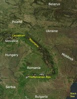
The Caves of Aggtelek and Slovak Karst (48°25'-48°40'N, 20°15'-21°00'E) are World Heritage Sites located on the international border between southern Slovakia and northeastern Hungary. (Caves of Aggtelek and Slovak Karst, Hungary and Slovakia)
Geographical Location
Straddles the southern foothills of the Carpathian mountains on the international border between southern Slovakia and northeastern Hungary. Lies within Borsod-Abaúj-Aemplén county in Hungary and Roznava District and Kosice county District in Slovakia. The caves lie within Aggtelek National Park and Slovensky Kras Protected Landscape Area. 48°25'-48°40'N, 20°15'-21°00'E
Date and History of Establishment
- The Hungarian Aggtelek Karst was first declared a protected landscape area in 1978 under decision No.8/1978 of the President of the National Authority for Environment and Nature Conservation (OKTH),
- In 1985 was redesignated a national park by law-decree No.7/1984 (XII.29) OKTH. Slovak Karst was proclaimed a protected landscape area in 1973 by Decree of the Ministry of Culture No. 110/1973 under the Act on the Protection of the Nature No.1/1955 Zb.
- Both sites have been individually accepted under UNESCO's Man and the Biosphere Programme; Aggtelek National Park in 1979 and Protected Landscape Area Slovak Karst in 1977.
- The caves systems of these protected areas were jointly inscribed on the World Heritage List in 1995.
Area
The terrestrial area that protects the caves comprises Aggtelek National Park (19,708 hectares (ha)) and Protected Landscape Area Slovak Karst (36,165 ha). However, the area of the World Heritage Property is considerably smaller as it only includes the caves themselves.
Land Tenure
State.
Altitude
No information.
Physical Features
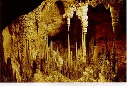
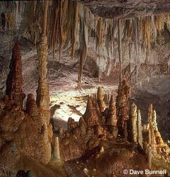
This is the most extensively explored karst area in Europe, and a total of 712 caves have so far been identified. Many of the younger caves which have formed at the plateau edges, such as Krásnohorská and Gombasecká, occur on several levels and contain dripstone decorations. The most notable of these is the Baradla-Domica cave system which is 21 kilometers (km) long and connects Hungary with Slovakia. It has a cavern capable of holding 1,000 people, a 13 meters (m) long stalactite and the autochthonous underground river Styx. These caves are also noted for having the world's highest stalagmite (32.7 m), aragonite andsinter formations and an ice filled abyss, which considering the territory's height above sea level, is a unique phenomena for central Europe. All these karst landforms are the result of long term geomorphological processes typical of this temperate climatic zone. Hydrological conditions are characterized by a lack of surface streams, except between mountain basins, and the complex circulation of underground water.
Climate
Under the influence of the Carpathian mountains, the climate is humid continental with long summers. The average temperature in the lower regions is -3°C in January and 19°C in July. These values decrease with an increase in altitude to -7°C and 14°C, respectively. Annual rainfall totals 620 millimeters (mm) in the lowest and 1,000 mm in the highest part of the tablelands. Depending on the elevation, snow cover persists between 60 and 139 days.
Vegetation
Not applicable.
Fauna
Of particular scientific interest are the cave and subterranean aquatic fauna. Beetles including Duvalius bokori bokori and D. hungaricus brzotinensis, and insects such as Limonia nubeculosa, Tarnania fenestralis and Eccoptomera obscura are abundant. Cave worms including Peloscolex velutinus and Rhyacodrilus falciformis are often found in sand and clay deposits, whilst molluscs namely Bythinella austriaca, Pisidium personatum and P. casertanum are associated with underground streams. The endemic snail Sadleriana pannonica also occurs. Crustaceans such as Niphargus tatrensis and Gammarus fossarum occur. The most notable primitive crab is the endemic species Niphargus aggtelekiensys.
Cultural Heritage
Archaeological findings suggest that the Baradla-Dominca Cave system was inhabited and used as a sanctuary and burial place since Neolithic times. Pottery relics from the Bukk, Pilin and Hallstatt cultures have been found within Silická l'adnica Ice Cave and a Hussite inscription dated to 1447 on the walls of Jasovská Cave. Documentary evidence of the caves of Aggtelek first appeared in the 13th century, whilst the Slovak caves were only mentioned in the mid 16th century. Some caves, such as Béke, have a long tradition in the treatment of illnesses such as asthma and lung diseases.
Local Human Population
Not applicable.
Visitors and Visitor Facilities
Tourists have been visiting the Hungarian caves since 1806, when the first stairs and fences were constructed. Currently, tourist access in Aggtelek National Park is restricted to three caves which are open throughout the year, namely Béke, Rákóczi, and Baradla-Domica caves. Of these the latter is the most popular, receiving between 150,000 and 200,000 visitors per year. Various signposts have been set up around the national park and protected landscape area.
Scientific Research and Facilities
The caves have a long history of research. In 1794, the world's first cave map, based on a 2-km section of Baradla cave, was produced by Jószsef Sartory and by 1825, over 8 km of passage had been mapped. Research has been conducted on flora, fauna, speleology, geomorphology and geology of both territories. In addition to this, a complex floristic and phytoecological survey was undertaken in 1970 on a selected part of the Slovak Karst namely the Silice Tableland, by the Department of Geobotanics of the Natural Science Faculty, Comenius University. The flora of the site has been recorded in over 100 publications. For the period 1976 to 1980, approval was given for a complete survey of the entire Slovak Karst within the state plan of research for Comenius University. Educational institutes including schools and universities arrange field trips to the caves.
Conservative Value
The caves of Aggtelek and Slovak Karst are noted for their unique karst landscape comprising physical and biological formations which are of great aesthetic and scientific value.
Conservation Management
Under the auspices of the National Authority for Nature Conservation, Aggtelek is administered by the Aggtelek National Park Directorate in collaboration with the Speleological Institute and the Hungarian Speleological Society. Management objectives are based upon the findings of scientific investigations and include protecting terrestrial habitats as well as the caves themselves, regulating scientific explorations and research within the caves and increasing services such as information, interpretation and education. Those caves not open to the public, have been locked with safety doors, eliminating unauthorized entry. The management plan is currently being updated and is expected to be completed later this year.
Under the Innovated Statue issued by the Ministry for the Environment, Slovak Karst is managed by the Administration of the Slovak Caves in cooperation with other national agencies namely Slovak Agency for the Environment, Slovak Speleological Society and the Slovak Museum for the Nature Protection and Caving. Management objectives include maintaining the accessible caves, providing information and education services and coordinating further research.
Management Constraints
Pollution (Water pollution) of cave waters from the increase use of pesticides and fertilizers is a serious threat. This has been mainly brought about by changes in agricultural practices.
Staff
No information.
Budget
No information.
IUCN Management Category
- Unassigned
- Natural World Heritage Site - Criterion i
Further Reading
- Aggtelek National Park Directorate. (1994). Caves of Aggtelek and Slovak Karst World Heritage Nomination. Aggtelek National Park Directorate. 63 pp.
- Anon (1985). Acid rain devastates Eastern Europe. WWF News. 23 Jan/Feb
- Berczik, A. (1983). Adaptability of Monitoring Systems in the Mangement of Biosphere Reserves - Experiences in Hungary. In: Conservation, science and society. Contributions to the First International Biosphere Reserve Congress, Minsk, Byelorussina/USSR. Unesco-UNEP. Pp. 384-388. ISBN: 9231022547.
- Budai, G. (1981). The phytoecnological and ecological evaluation of gravel-back near Aggetelek. Mss. Debrecen. (Unseen).
- Carter, F.W. (1984). Pollution problems in post-war Czechoslovakia. Transactions-Institute of Bristish Geographers New Series 10:17-44. (Unseen).
- Denes, G. (1984). The 700 years history of Bodvaszilas Basin. Hermann Otto Museum, Miskolc. (Unseen).
- Haberova, I. (1975). Vegetation associations of the alluvia of the Silice Plateau. Proceedings of the 2nd SBS Congress in Presov. (Unseen).
- Klinda, J. (1985). Chranene Uzemia Prirody v Slovenskej Socialistickij Republike Vydavatel'stvo Obzor, Bratislava. (Unseen).
- Lamac, J. and Stackmann, V. (1985) (Eds.). Chranena Krajinna Oblast Slovensky Kras. Vydalo Vydavatcl'stvo Obzor n.p. pre Ustredic statncj ochrany prirody. Liptovskom Mikulasi. (Unseen).
- Povolny, F. and Voloscuk, I. (1986). Management of Biosphere Reserves in Czechoslovak protected areas' network. Paper presented at All European MAB Conference, March 1986. (Unseen).
- Slovenská agentú zivotného prostredia. (1994). Caves of the Aggtelek and Slovak Karst World Heritage Nomination. Slovenská agentú zivotného prostredia. 74 pp.
- Varga, Z. (1973). Zoo-geographical examinations of large butterfly fauna of north-Borsod Karst. Folia Entomologica Hungarica 14/23. (Unseen).
- Udvardy, M.D.F. (1985). New National Park in Hungary. Parks 10(2): 22.
- Further references can be found the both World Heritage nominations
| Disclaimer: This article is taken wholly from, or contains information that was originally published by, the United Nations Environment Programme-World Conservation Monitoring Centre (UNEP-WCMC). Topic editors and authors for the Encyclopedia of Earth may have edited its content or added new information. The use of information from the United Nations Environment Programme-World Conservation Monitoring Centre (UNEP-WCMC) should not be construed as support for or endorsement by that organization for any new information added by EoE personnel, or for any editing of the original content. |