Cauca Valley montane forests
The montane forests of the Cauca Valley in southwestern Colombia are highly diverse and are an important center of endemism of plants and animals. However, the ecoregion has suffered large losses of forest cover and only small remnants of native vegetation remain, especially at the lower elevations.
Location and General Description
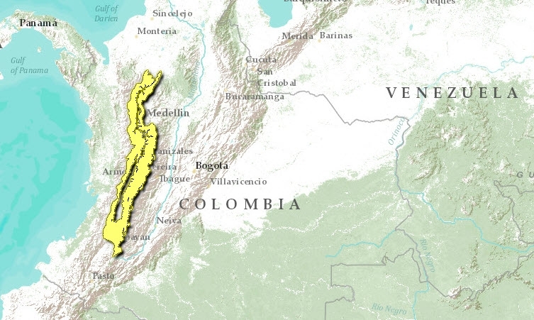
Located at the northwestern end of the Andes Mountain Range in southwestern Colombia, the Cauca Valley, nestled between the Western and Central ranges of the Andes, stretches for 600 kilometers (km) in a south-north direction between 2° and 8° N latitude. The gentle slopes of the Cauca Valley foothills, starting at an elevation of 1000 meters (m), give way to an abrupt topography at higher elevations, with deep canyons and numerous rivers and streams that drain into the Cauca River. Elevations of the Central Andes reach over 5,000 m with several volcanoes and perpetually snow-capped peaks. The Western Cordillera, lower and narrower than the Central, reaches elevations of up to 4,000 m.
Geologically the ecoregion has a complex history, and the two mountain ranges that form the valley’s borders have different origins. Orogenesis of the Colombian Andes started in the late Paleozoic, when the ancestral Central Cordillera was insinuated at the western margin of a miogeosyncline. The Central Cordillera was emergent but low during the Cretaceous. Orogeny of the Western Cordillera can be traced to the close of the Mesozoic. Andean folding during the Miocene gave rise to the present configuration of three Colombian Cordilleras and two inter-Andean valleys. Present elevations were reached during the Pliocene-Pleistocene. On the western range, soils are lateritic, and there are some limestone deposits on the foothills. On the Central range, in contrast, soils are of volcanic origin and highly fertile.
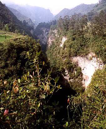
 Cañon de Combeima, Tolima, Colombia Photograph by Luke Mastin The vegetation communities of the Cauca Valley montane forests are very diverse and range from dry enclaves in the foothills of the eastern versant of the Western range of the Andes (precipitation 500-1000 millimeters [mm]/year), to very humid forests on the middle and upper elevations of the western versant of the Central range (precipitation up to 3,000 mm/year). Together with the steep altitudinal gradient, this climatic diversity results in high beta species diversity and endemism. The altitudinal gradient produces a rapid species turnover and congeneric replacements of species. Point or alpha diversities are not very high when compared with the lowlands, but regional diversities are very high because of the altitudinal species turnover. For example, bird diversity at particular localities within an altitudinal belt may be below 200 species, but total diversity along an altitudinal gradient may exceed 500 species. The montane forests on the valley’s slopes extend from 1,000 m to >3,000 m and include the sub-Andean and Andean altitudinal belts.
The humid forests of the lower elevations (<1,500 m) are dominated by species of Leguminosae and Moraceae, while at middle elevations (1500-3000 m) Lauracea, Melastomataceae and Rubiacea are the most speciose families. At higher elevations, above 3,000 m, the flora is dominated by species of Ericaceae and Asteraceae. Prominent species of plants include palms of the genus Ceroxylon, of which the species C. quindiuensis is probably the tallest palm in the world, reaching more than 60 meters. The Andes of Colombia, including the Cauca Valley montane forests, are a center of diversification and radiation of several taxonomic groups, including frogs of the genus Eleutherodactylus and shrubs and epiphytic plants in the families Gesneriaciae, Orchidaceae, Rubiaceae, and Melastomataceae, among others.
Biodiversity Features
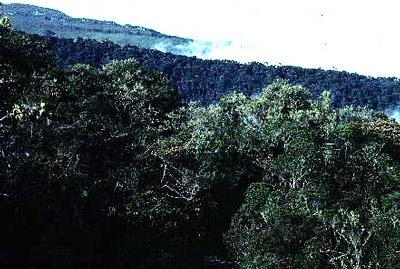
 Risaralda, Colombia. (Photograph by WWF/ Jorge Orejuela)
 The Cauca Valley montane forest ecoregion holds a wealth of species of plants and animals. Within an area of 32,412 km2, this ecoregion contains more than 500 species of birds, 92 species of frogs, 120 species of mammals, and 200 species of butterflies. This ecoregion is also a center of endemism for several plant and animal taxa and contains one of the Endemic Bird Areas determined by BirdLife International, with 12 restricted-range species (4 of which occur nowhere else) in an area of 19,000 km2. One of these species is the Cauca guan (Penelope perspicax), which occurs in humid forest at elevations between 1,200 and 2,200 meters (m) on both slopes of the valley, and is presently relegated to a few forest remnants. More remarkable is the case of frogs; of which 60 species are endemic to the ecoregion.
The biological diversity of the montane forests of the Cauca Valley is the result of complex patterns of biological diversification, related to the ecoregion’s geological history, and present topographic and climatic diversity. Frogs, for example, show a pattern of allopatric or horizontal differentiation where populations are isolated on different slopes, which adds to the differentiation of species along altitudinal gradients. Likewise, some butterflies such as the tribe Pronophilini show a double pattern of speciation, one in which closely related species are on different Andean slopes (allopatric speciation), and a second one in which close allies are in different altitudinal belts on the same slope (parapatric speciation). Another factor that contributes to the ecoregion’s biological diversity is the biotic interchange that occurred between North and South America when the Central American isthmus was established. Many of the Laurasian floristic elements that invaded South America differentiated in the northern Andes, where they represent important ecological elements in middle and high elevation forests (e.g., Alnus, Quercus, Talauma, Juglans).
The Cauca Valley montane forests contain populations of a number of species of special concern, including large mammals such as spectacled bear (Tremarctos ornatus) and mountain tapir (Tapirus pinchaque), and restricted-range and/or endangered bird species such as Cauca guan (Penelope perspicax), brown-banded and moustached antpittas (Grallaria milleri and G. alleni), multicolored tanager (Chlorochrysa nitidissima), and golden-plumed parakeet (Leptosittaca branickii). Some of these species, such as the golden-plumed parakeet and quetzals (Pharomacrus spp), undergo regional migrations along the slopes of the Andes.
Current Status
The montane forests of the Cauca Valley are strongly fragmented, especially at the lower elevations. Between 1,000 and 2,000 meters (m), most forest has disappeared, and only scattered remnants remain. The largest remaining block within this elevational belt is the Yotoco Forest Reserve, with an extension of 519 hectares (ha). Substantial forest remains at the higher elevations, on both slopes of the valley. However, only small portions receive nominal protection in national parks such as Farallones de Cali, Tatamá, and Los Nevados. Some protection is also afforded by small regional reserves such as Ucumarí Regional Park.
Types and Severity of Threats
The major threat to the ecoregion’s biodiversity is continuing degradation of lands surrounding forest fragments, and of the fragments themselves, although there are some regional restoration initiatives, and many fragments are protected. In some areas, higher-elevation forests outside of national parks are still being exploited for timber and other forest products. Illegal hunting is also a problem in the area, affecting mostly large birds and mammals such as cracids and large rodents.
In spite of the great degree of fragmentation and other threats resulting from a dense human population, the ecoregion still supports a diverse and unique biota. There are many initiatives to contain and revert the damage, such as the creation of regional reserve networks that involve the public and private sectors.
Justification of Ecoregion Delineation
These montane forests encompass the Cauca Valley watershed, including the eastern slopes of the Cordillera Central and the western slopes of the Cordillera Oriental around the watershed and extending into the Magdalena Valley to the north. Linework follows the 1,000-meter elevational contour at its lower limits – marking the transition from dry to montane moist forests. This is a coarse boundary, as current vegetation does not reflect historic distributions of these forests, although reference was made to historic coverage. The northern delineation was made at the approximate location along the valley where the dry forests species association grade to moist forest association. Current vegetation coverage’s were also considered. Linework was reviewed and modified at an ecoregion priority setting workshop.
Further Reading
- Adams, M. J. 1986. Pronophiline butterflies (Satyridae) of the three Andean Cordilleras of Colombia. Zoological Journal of the Linnean Society 87:235-320.
- Bibby, C. J., N. J. Collar, M. J. Crosby, M. F. Heath, C. Imboden, T. H. Johnson, A. J. Long, A. J. Stattersfield, and S. J. Thirgood. 1992. Putting biodiversity on the map: priority areas for global conservation. Cambridge, UK: International Council for Bird Preservation. ISBN: 0946888248
- Cavelier, J. 1997. Selvas y bosques montanos. Pages 38-55 in M. E. Chaves, and N. Arango, editors, Informe nacional sobre el estado de la biodiversidad. Instituto de Investigación de Recursos Biológicos A. von Humboldt, Bogotá, Colombia.
- Complejo Ecoregional de los Andes del Norte (CEAN). Experts and ecoregional priority setting workshop. Bogota, Colombia, 24-26, July, 2000.
- Gentry, A. H. 1982. Neotropical floristic diversity: phytogeographical connections between Central and South America, Pleistocene climatic fluctuations, or an accident of the Andean origeny? Annals of the Missouri Botanical Garden 69:557-593.
- Instituto Geográfico "Agustin Codazzi". 1976. Mapa ecológico de la República de Colombia. Ministerio de Hacienda y Crédito Público. Bogotá, Colombia.
- Instituto Geografico "Agustin Codazzi". 1985. Mapa de bosques. Bogotá, Colombia.
- Irving, E. M. 1975. Structural evolution of the northernmost Andes, Colombia. U. S. Geological Survey Professional Paper 846.
- Lynch, J. D. 1986. Origins of the high Andean herpetological fauna. Pages 478-499 in F. Vuilleumier and M. Monasterio, editors, High altitude tropical biogeography. Oxford, UK: Oxford University Press. ISBN: 0195036255
- Lynch, J. D., P. M. Ruiz, and M. C. Ardila. 1997. Biogeographic patterns of Colombian frogs and toads. Revista de la Academia Colombiana de Ciencias 21:237-248.
- Navarro, A.E.S., G.H. Peña, F.C. Lemus, J.R. Baquero, and R.F. Soto. 1984. Bosques de Colombia. IGAC-INDERENA-CONIF, Bogota, Colombia.
| Disclaimer: This article contains some information that was originally published by the World Wildlife Fund. Topic editors and authors for the Encyclopedia of Earth have edited its content and added new information. Use of information from the World Wildlife Fund should not be construed as support for or endorsement by that organization for new information added by EoE, or for any editing of the original content. |

