Burnt Cape (Conservation Biology)
Contents
Burnt Cape
| Topics: |
Geology (main)
|
The Burnt Cape is a limestone barren headland on the extreme northwest of the Northern Peninsula of Newfoundland, Canada. The prevailing harsh cold climate and calcareous soils have created a natural environment that is hospitable to certain extremophile plant species, many of which are rare or have limited geographic distribution. The site has experienced damage from gravel extraction in the latter part of the twentieth century, although most of the habitat remains intact. Due to the need to protect the biodiversity of Burnt Cape from mineral exploitation, the site has been designated as a protected area known as the Burnt Cape Ecological Reserve, by the Government of Newfoundland and Labrador. There are over 300 plant species present on this inhospitable site, with more than 30 being rare and two being near-endemics.
Geology
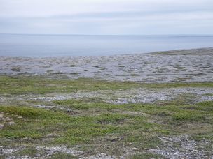
 Limestone barrens along the Strait of Belle Isle, Burnt Cape. @ C.Michael Hogan The dominant rock formation at Burnt Cape is limestone, with surface soils being highly fractured by the intense persistent freeze-thaw cycles that have ensued since glacial retreat that commenced in the early Holocene. Evidence of glacial scraping is visible in elongated striated grooving of the surface limestone; these exposed limestone beds are positioned more or less horizontally, resulting from glacial grinding advance across the Burnt Peninsula. Massive glaciers would have been present here prior to the Holocene, presenting an enormous scraping force as well as downward weight on soils.
A large fraction of the Cape's land area is covered by either expansive exposed limestone or shattered limestone gravels of characteristic sizes from ten to twenty millimetres. Due to the uniform sizing of these gravels, they became attractive targets for exploitation during the twentieth century, a practise which ceased only in the early 1990s with a protective order on Burnt Cape. The surface quarrying has caused considerable ecological damage with surface scarring due to gravel extraction, access roads and from sloughage over the bluff areas, with an outcome of habitat destruction for a portion of the Cape.
In numerous locations there are depressions in the local topography of the limestone coastal terrace; these hollowed out areas are of characteristic lateral dimensions ranging from tens of metres to over 100 metres; these zones have generally been filled by soil particles in natural processes of sediment accretion, during and after glaciation, such that resulting soil depths here are more highly developed than on the gravels and exposed limestone. Resulting soil depths in these depresseions range from a few centimetres to as much as one metre. In most cases the soil depths limit full root development for tree species, with the result being formation of patches of tuckamore (dwarfed) forests of black spruce and tamarisk. Such stunted forests here rarely attain canopy heights exceeding two metres; furthermore, the trees are generally flagged in appearance due to wind pruning.
 Burnt Cape headland, evincing three terraces of post-glacial rebound. @ C.Michael Hogan After glacial retreat beginning in the early Holocene, the enormous gravitational weight of the glaciers subsided as the glaciers melted. As a result the land elevation rose, creating uplifted areas. This process, known as post-glacial rebound, created uplift of the land at Burnt Cape, most notably at the bluff area of the sea caves where the cape tip contacts the Strait of Belle Isle. In this location there are actually three layers of post-glacial rebound (sometimes called isostatic rebound), manifested by three tiered coastal terraces. The sea caves present here are themselves uplifted, such that the cave floors are generally above sea level and are dry, presenting further evidence of the rebound phenomenon.
Another unusual feature found atBurntCape is the presence of frost polygon phenomena. The Arctic circumstnces have also led to the formation of these frost polygons, which appear as mysterious geometric shapes or lines of rocks on the surface of the ground. These micro-topographic landforms are produced by the intense freeze/thaw cycles present at the Cape; such shapes imprinted on the ground are typically found only in northern or Arctic areas of permafrost. The frost polygons at the Burnt Cape appear variously pentagonal, hexagonal or circular and have characteristic dimensions from one to several metres.
Vegetation
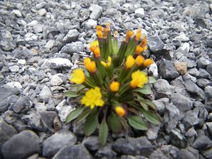
 The rare dwarf hawksbeard (Crepis nana). @ C.Michael Hogan The plant assemblage of Burnt Cape is an extraordinary array of dwarfed and miniature species. The herbaceous species are stunted in stature due to the thin calcareous soils as well as the extreme cold temperatures and high wind conditions. Woody vegetation such as dwarf birches, juniper and black spruce exhibits extreme dwarfism on the limestone barrens, but also manifests flagging characteristics where the soils are the most highly developed and trees can achieve their maximum height here of about two metres..
The diverse flora assemblage features over 30 rare plant taxa, as well as a number of species with highly restricted distribution, including two near-endemics: the Burnt Cape cinquefoil (Potentilla usticapensis) and the dwarf hawkbeard (Crepis nana) are wo;df;pwers fpimd pm;y here and one other coastal limestone barrens.
Chief woody tree species present on the exposed limestone and gravelly surfaces are black spruce (Picea mariana). tamarisk (), lime willow () , and. Heath family membes occurring here include bearberry (Arctostaphylos uva-ursi), alpine bearberry (A. alpina), red bearberry {A. rubra}, partridgeberry (Vaccinium vitis-idaea). lowbush blueberry (V. angustifolium), alpine azalea (Loiselauria procumbens), creeping snowberry (Gaultheria hispidula), and Lapland rosebay (Rhododendron lapponicum).
 Yellow lady slipper orchid on the limestone barrens of Burnt Cape. @ C.Michael Hogan Among the herbaceous species there are twelve orchid taxa present at Burnt Cape: bluntseed sweetroot (Osmorhiza depauperata), early coralloroot orchid (Calorhiza trifida), lady's slipper orchid (Cypridium parviflorum), yellow lady's slipper orchid (Cypripedium parviflorum var. pubescens), fairy slipper orchid (Calypso bulbosa), Newfoundland orchid (Pseudoorchis albida), northern bog orchid (Platanthera hyperborean), scent bottle orchid (P. dilatata) long-bracted frog orchid (Coeloglossum viride), small round-leaved orchid (Amerorchis rotundifolia), broad-lipped twayblade (Listeria convallarioides) and heart-leaved twayblade (L. cordata)
Other species recorded on Burnt Cape include the insectivorous butterwort (Pinguicula vulgaris), dwarf enchanter's nightshade (Circaea alpina), Laurentian eyebright (Euphrasis suborbicularis), island gentian (Gentianopsis nesophila), goldthread (Coptis trifolia), lady's mantle (Alchemilla filicaulis}, Newfoundland oxytrope (Oxytropis campestris), northern commandra (Geocaulon lividum), northern sand spurry (Spergularia canadensis), pulvinate pussytoes (Antennaria pulvinata), purple avens (Geum rivale), pink pyrola (Pyrola asarifolia), river beauty (Epilobium latifolium) and the edible flower, purple saxifrage (Saxifraga oppositifolia).
Climate
The meteorology of the Burnt Cape is characterised by harsh cold winters, along with high velocity winds that persist year around; this site also boasts the highest precipitation levels of any location in Newfoundland. Cold sea currents arrive from the Sea of Labrador, funneling through the Strait of Belle Isle, the waterway into which the Cape intrudes; moreover, these icy currents actually convey icebergs into the Strait on a regular basis, all the way from their calving origin in Greenland, further exacerbating the year around wintry feeling at the Cape. There are icebergs here regularly through June, and sometimes even later into the summer. The icebergs flow southward with the prevailing current and eventually dissipate as they melt in the Gulf of St.Lawrence. Winter snowpack is appreciable, adding to the dwarfing and compression of the Cape flora, as well as to their impeded growth rates; some of these minute plants grow so slowly and persist so long, that there are specimens no more than a few centimetres high that are centuries old!
Fossils
A number of significant Fossil finds have been recovered from Burnt Cape, including the semi-elliptical bivalve Strophomena aurora. Fossils of this species have also been recovered at nearby Pistolet Bay and a site near Portland Creek. All members of this extinct marine gastropod genus were stationary epifaunal suspension feeders. These brachiopods (sometimes termed lamp shells) thrived from the Ordovician period to the Silurian period.
Hormostoma augustina (previously known as Murchisonia augustina) is another exinct taxon whose fossil is found at Burnt Cape. This large univalve is also known in fossil form from Point Rich, Table Head and Pistolet Bay. The entire genus of Homostoma is now extinct with no extant descendents known.
References
- Elkanah Billings and Joseph Frederick Whiteaves. 1865. Palaeozoic fossils: Volume 2, Part 1. Geological Survey of Canada books.google.com
- Geological Survey of Canada. 1946. Geological Survey paper: Volume 46, Issue 15 books. google ebook
- L.Hartery. 2007. The Cow Head Complex and the Recent Indian Period in Newfoundland, Labrador, and the Quebec Lower North Shore. Occasional Papers in Northeastern Archaeology No. 17. Copetown Press, St. John’s.
- S.Meades, S.G.Hay and L. Brouillet. 2000. Annotated Checklist of the Vascular Plants of Newfoundland and Labrador. The Provincial Museum of Newfoundland and Labrador. Co-operative Projects and Partnerships.
