Bay of Bengal
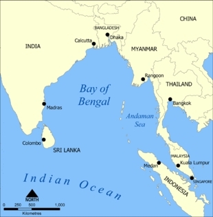
The Bay of Bengal is the northeastern arm of the Indian Ocean, located between peninsular India and Myanmar (Burma). It covers about 2,200,000 square kilometers; this marine body is bordered on the north by the Ganges and Brahmaputra River deltas, on the east by the Burmese peninsula and the Andaman and Nicobar Islands, on the west by India proper and Sri Lanka, and on the south by the Indian Ocean proper. The average depth is around 3000 meters (m) with maximum depths reaching over 400 m in the southern parts of the Bay of Bengal.
Contents
Hydrography and circulation
Major circulation features are the East Indian Current, a northward current flowing along the Indian shelf from January through October, and the East Indian Winter Jet, a southwestward flowing current that replaces during the remainder of the year. This current reversal is due to the seasonal change from the Northeast to the Southwest Monsoon and the concomitant wind forcing. General clockwise and conterclockwise circulation gyres are seen throughout the Bay accompanying, respectively, the Current and the Winter Jet, although the situation becomes somewhat more complicated during the transition periods.
The monsoonal wind variations and the resulting circulations also serve to induce upwelling near the coasts during the spring (with the northward current) and the piling up of surface water along the coasts during the late fall and early winter (with the southward currents). Thus the isopycnals tilt upwards and downwards towards the shore during, respectively, the spring and late fall. The annual mean SST for the region is above 28.5 degrees Celsius (C), although upwelling can reduce this to within the range of 25 to 27 degrees C during the spring. The salinities are kept lower than normal oceanic values (especially in the western parts) by extensive monsoonal river discharge.
Bay of Bengal water mass
Bay of Bengal Water (BBW) is a water mass that originates in the northern Bay of Bengal via monsoonal input from the Ganges and Brahmaputra Rivers. It is a low salinity water mass that spreads across the Bay in an approximately 100 m thick layer that produces a strong halocline beneath (above the overlying Indian Central Water) and keeps the surface salinity in the eastern parts of the Bay below 33.0 throughout the year. Although there are no variations in temperature through the BBW layer, there are salinity variations below 50 m (and therefore above the main halocline) due to the fact that weak wind mixing erases variations over only about half the depth of the layer. This causes the permanent existence of a barrier layer. The low salinity surface water to the west of India, sometimes called East Arabian Sea Water (EAW), is usually subsumed under the BBW rubric due to its nearly identical properties.
See Also
- [[Andaman] Sea]
- Bay of Bengal large marine ecosystem
- Singapore Strait
Further Reading
- Seas of the World on Encyclopedia of Earth
- Matthias Tomczak and J. Stuart Godfrey. Regional Oceanography: An Introduction. Pergamon, 1994.
- Rhodes W. Fairbridge, editor. The Encyclopedia of Oceanography. Van Nostrand Reinhold Co., 1966.
- S. R. Shetye, A. D. Gouveia, D. Shankar, S. S. C. Shenoi, P. N. Vinayachandran, D. Sundar, G. S. Michael, and G. Nampoothiri. Hydrography and circulation in the western Bay of Bengal during the northeast monsoon. JGR, 101:14,011–14,026, 1996.
