Andaman Sea
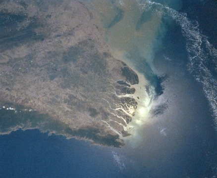
Irrawaddy Delta draining to the Andaman Sea. Source: National Aeronautics and Space Administration
Seas of the World ![]() The Andaman Sea is a body of marine water in the northeastern corner of the Indian Ocean that lies to the west of the Malay Peninsula, the north of Sumatra, the east of the Andaman Islands, and the south of the Irrawaddy Delta in Myanmar.
The Andaman Sea is a body of marine water in the northeastern corner of the Indian Ocean that lies to the west of the Malay Peninsula, the north of Sumatra, the east of the Andaman Islands, and the south of the Irrawaddy Delta in Myanmar.
It stretches about 650 kilometers (km) from west to east and 1200 km from north to south.
| This article is written at a definitional level only. Authors wishing to expand this entry are inivited to expand the present treatment, which additions will be peer reviewed prior to publication of any expansion. |
The Andaman communicates with the westward lying Bay of Bengal through several channels between the chain of islands that stretches along 93 degrees E., including the Preparis (200 meters deep), Ten Degree (800 meters deep) and Great (1800 meters deep) Channels. It is connected with the Australasian Mediterranean Sea via the Malacca Strait between Thailand and Sumatra. It has been variously estimated to have an area of 600,000 to 800,000 km2 and an average and maximum depth of, respectively, 870-1100 meters (m) and 4200 m.
The temperature of the surface waters fluctuates mildly from a monthly average of about 30 degrees Celsius (C) in the summer months to one of about 27.5 degrees C in the winter months. They drop off with depth to about five degrees C and 2000 m. The surface salinities exhibit strong seasonal variations due to an extremely large freshwater influx from the Irrawaddy and Salween rivers during monsoon season. In the northern part the salinities range from about 20 during the monsoon months from June to November to about 32 from Demember to May. These grade to a fairly constant 33.5 in the southwest end and to a maximum of about 35 near 1500 m in depth.
The steadiest current is the inflow through the Malacca Straits, averaging around one and one third to two knots through the year. The monsoons controls the currents elswhere, driving inflow waters from the Bay of Bengal through the western channels from June to August during the southwest monsoon. This also pushes the Malaccan inflow against the Sumatran coast and forces some Andaman sea water through the Straits. When these winds die southwestward currents gradually form that are maintained and enhanced by the northeast monsoon from December through February. A more sudden shift is seen from March through May when the southwest monsoons begins anew.
 Regional setting of Andaman Sea. Source: Norman Einstein
See Also
- Singapore Strait
- Strait of Malacca
Further Reading
- Physical Oceanography Index
- Seas of the world on the Encyclopedia of Earth
- Rhodes W. Fairbridge, editor. The Encyclopedia of Oceanography. Van Nostrand Reinhold Co., 1966.