Singapore Strait
Contents
Singapore Strait
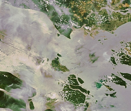
Singapore Strait (image right) joins to Strait of Malacca (image left). Source: NASA
Seas of the World ![]() The Singapore Strait is an oceanic water body between Singapore and Indonesia, connecting the South China Sea with the Strait of Malacca.
The Singapore Strait is an oceanic water body between Singapore and Indonesia, connecting the South China Sea with the Strait of Malacca.
This maritime waterway is an important modern crossroads of international shipping, and has been a crucial shipping lane since ancient times.
Due to heavy ship movements and intensive industrialization in the region, the Singapore Strait has also become a locus of marine pollution. Correspondingly the fisheries of the Singapore Strait have significantly and steadily declined in productivity over the last six decades.
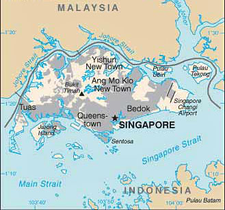 Regional setting of the Singapore Strait. Geography
The Strait of Singapore is situated south of the island nation of Singapore, which itself is separated by a narrow channel, known as the Strait of Jehore, from the Malay Peninsula. To the west the Singapore Strait connects to the Malacca Strait, which in turn is a major passage to the Indian Ocean.
The port of Singapore as well as the urban center of Singapore and Singapore Changi International Airport are all prominent features along the northern edge of the Singapore Strait.
Much of the coastal zone along the southern shore of the principal island of Singapore is reclaimed land from filling of wetlands.
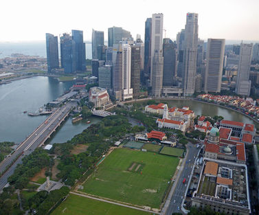 Urban centre of Singapore with Singapore Strait beyond. @ C.Michael Hogan
The southern edge of the Singapore Strait is demarcated by the Riau Archipelago of Indonesia.
Hydrography and currents
Trade winds and Asian monsoons are chief drivers of the complex current system comprising the Singapore Strait. Water transport within the Singapore Strait is dominated by a robust hydrodynamic pressure gradient that completely reverses direction twice per year, correspondent to the monsoonal cycle; tidal forcing is also a factor in the pressure gradient.
The Singapore Strait is rather narrow at its eastern join toward the South China Sea; however, the narrowest element is the central portion of the strait, termed Main Strait.
There are numerous tiny islands in the Singapore Strait, and the subsurface is replete with irregular underwater channels and marine canyons. The bathymetry exhibits a depth variation form several meters to a channel depth of about 130 meters, with a mean depth of approximately 40 meters.
In general, tidal streams at the western entrance to the Singapore Strait flow in a south-southwest or north-northwest vector; at the eastern side of the strait tidal flows are in the west-southwest or east-northeast direction. At locations where landmasses constrict to the north and south, such as near Selat Jurong or Keppel, the flow is almost purely east-west. Tidal currents are typically on the order of three knots, but may attain values of six knots in the narrowest part of the strait.
As far as monsoonal forcing, the Singapore Strait receives inflow from the South China Sea during the northeast monsoon and influx from the Java Sea during the southwest monsoon.
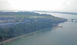 Shallow coastal waters of Singapore Strait, Singapore main island
@ C.Michael Hogan
Marine ecology
Due to the topographic complexity of the channel bottom and temporal current changes, there is considerable variation in species occurrence within the Singapore Strait, both spatially and temporally.
Primary phytoplanktonic producers vary dramatically over short time scales, and do not exhibit a prolonged bloom. Phytoplankton are much more abundant in the Singapore Strait than the Jehore Strait, likely due to the absence of high densities of phytoplankton grazing fish in the Singapore Strait in comparison to the Johore Strait.
Diatoms such as Rhizosoleniophycidae and Coscinodiscophyceae are present in the Singapore Strait year around; more specifically, diatoms within the genera Bacteriastrium, Hemidiscus and Thalassiosira also occur year around.
Common zooplankters occurring in the Singapore Strait include: members of the phyllum of arrow worms known as chaetognatha; taxa within the order of Siphonophorae, colonial hydrozoans; and certain species within the sea squirt genus Oikopleura.
There are a considerable number of fish species that occur in the Singapore Strait, most of which are using these waters as feeding grounds, the fish being swept in from the South China Sea. However, the abundance of total fish stock has declined markedly since around mid twentieth century, due to increases in the local human population, associated water pollution, overfishing and underwater noise pollution from intense shipping traffic.
Water quality has been particularly degraded from elevated turbidity and phosphate levels; high turbidity is caused by dredging as well as sewage discharge, whereas phosphate concentrations are due to agricultural runoff. Dredging has been conducted both for ship channel enlargement as well as a massive effort to fill coastal wetlands to enlarge industrial land holdings. This land reclamation has been particularly notable in Singapore, where a significant percentage of that nation's land area has actually been created by fill since 1950.
Terrestrial ecology
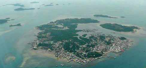 Aerial view of a portion of the Riau Archipelago.
See main articles: Sunda shelf mangroves; Sumatran peat swamp forests
The fringe of the Singapore Strait along the Riau Archipelago contains occurrences of the Sunda shelf mangroves. On the seaward sediments, Avicennia-Sonneratia forest dominates. Moving inland, there is softer and deeper mud sediment dominated by Rhizophora-Bruguiera forests. Further inland, the soils become firmer and the forests display a greater species diversity. In areas with a substantial freshwater influence, Nypa palms dominate.
Further inland from the Riau Archipelago coastline are occurrences of the Sumatran peat swamp forests. Peat soil is composed of more than 65 percent organic matter. Most peat deposits found behind mangroves along the coast are ombrogenous, or rain-fed peat swamps. Peat swamp forests are formed when surface runoff drains into the inland edge of a mangrove and the sediments are trapped behind the tangle of mangrove roots. These areas begin to build up and flood less often as the coastline extends outward. The peat deposits usually are at least 50 centimeters (cm) thick. Peat swamps are domed and are rarely flooded. Because peat swamps are not drained by flooding, they are nutrient deficient and acidic, with a pH usually less than 4. Compared with other moist forest ecoregions, peat forests in the lowlands-are not as species-rich and are not high in endemism.
The southern fringe of Singapore contains some mangrove and lowland tropical rainforestoccurrences; however, most of this habitat has been severely degraded and fragmented due to the intense coastal development of the island.
History
It is likely that the Singapore Strait was used in human migration and settlement of Sumatra, Borneo and other Indo-Pacific islands as early as the fifth century BC. Furthermore, Chinese traders had begun to use this sea lane to exploit trade with ancient India and Arabia from mainland ports such as Guangzhou as early as 200 BC.
During the Han Dynasty (210 BC-AD 220), clay tomb models in China demonstrate that side oars for steering Chinese ships were replaced by the innovation of a stern rudder. Ships of increasing size came into being during the Han, as evinced by archaeological recovery at an ancient Ch’in dockyard excavation at present day Guangzhou.
The Guangzhou dockyard’s slipways for hauling ships shows a capability of handling vessels with a beam or width of almost nine metres length of approximately 30 metres. Larger craft could accommodate more massive superstructures, including on deck fighting towers.
Since at least as early as the sixth century AD, the Singapore Strait has been a robust shipping corridor from the Pacific Basin to the Indian Ocean. Not only the Chinese, but also the Hindu power center of Srivijaya on Sumatra used the Singapore Strait for maritime commerce with distant ports in ancient Africa, Arabia and Persia.
By the time of the Song Dynasty the Chinese maritime leadership achieved total supremacy in this region, bolstered by the deployment of a robust navy. According to Jack-Hinton and others, the Singapore Strait is the route that Marco Polo likely utilized in his noted voyages.
References
- Ming Chen, K.Murall, Boo-Cheong Khoo, Jing Lou and Kurichi Kumar. 2006. Circulation Modeling in the Strait of Singapore. Journal of Coastal Research. 21:5 pp 960-972
- Lin Sien Chia, Habibullah Khan, L.M.Chou. 1988. The coastal environmental profile of Singapore. 91 pages books.google.com
- International Hydrographic Organization. 1953. Limits of Oceans and Seas, 3rd edition.
- Colin Jack-Hinton. 1964. Papers on early Southeast Asian history. 197 pages books.google.com
- National Geospatial-intelligence Agency. 2006. Prostar Sailing Directions: Pacific Ocean and Southeast Ocean Planning Guides. ProStar Publications.
- Pinxian Wang. 2009. The South China Sea: Paleoceanography and Sedimentology (Google eBook) Springer. 506 pages
- Eric D.Wikramanayake. 2002. Terrestrial ecoregions of the Indo-Pacific: a conservation assessment. Island Press. 643 pages