Atmospheric lapse rate
The atmospheric lapse rate refers to the change of an atmospheric variable with a change of altitude, the variable being temperature unless specified otherwise (such as pressure, density or humidity). While usually applied to Earth's atmosphere, the concept of lapse rate can be extended to atmospheres (if any) that exist on other planets.
Lapse rates are usually expressed as the amount of temperature change associated with a specified amount of altitude change, such as 9.8 °Kelvin (K) per kilometer, 0.0098 °K per meter or the equivalent 5.4 °F per 1000 feet. If the atmospheric air cools with increasing altitude, the lapse rate may be expressed as a negative number. If the air heats with increasing altitude, the lapse rate may be expressed as a positive number.
Understanding of lapse rates is important in microscale air pollution dispersion analysis, as well as urban noise pollution modeling, forest fire-fighting and certain aviation applications.
The lapse rate is most often denoted by the Greek capital letter Gamma ( Γ ) but not always. For example, the U.S. Standard Atmosphere uses L to denote lapse rates. A few others use the Greek lower case letter gamma.
Contents
Types of lapse rates
There are three types of lapse rates that are used to express the rate of temperature change with a change in altitude, namely the dry adiabatic lapse rate, the wet adiabatic lapse rate and the environmental lapse rate.
Dry adiabatic lapse rate
Since the atmospheric pressure decreases with altitude, the volume of an air parcel expands as it rises. Conversely, if a parcel of air sinks from a higher altitude to a lower altitude, its volume is compressed by the higher pressure at the lower altitude. An adiabatic lapse rate is the rate at which the temperature of an air parcel changes in response to the expansion or compression process associated with a change in altitude, under the assumption that the process is adiabatic (meaning that no heat is added or lost during the process).
Earth's atmospheric air is rarely completely dry. It usually contains some water vapor and when it contains as much water vapor as it is capable of, it is referred to as saturated air (i.e., it has a relative humidity of 100%). The dry adiabatic lapse rate refers to the lapse rate of unsaturated air (i.e., air with a relative humidity of less than 100%). It is also often referred to as the dry adiabat, DALR or unsaturated lapse rate. It should be noted that the word dry in this context simply means that no liquid water (i.e., moisture) is present in the air ... water vapor may be and usually is present.
The dry adiabatic lapse rate can be mathematically expressed as:The troposphere is the lowest layer of the Earth's atmosphere and almost all human activity takes place in the troposphere. Since g and cpd vary little with altitude, the dry adiabatic lapse rate is approximately constant in the troposphere.
Wet adiabatic lapse rate
An unsaturated parcel of air will rise from Earth's surface and cool at the dry adiabatic rate of – 9.8 K / kilometre (5.4 °F /&tninsp;1000 ft) until it has cooled to the temperature, known as the atmospheric dew point, at which the water vapor it contains begins to condense (i.e., change phase from vapor to liquid) and release the latent heat of vaporization. At that dew point temperature, the air parcel is saturated and, because of the release of the heat of vaporization, the rate of cooling will decrease to what is known as the wet adiabatic lapse rate. This rate is also often referred to as the wet adiabat, saturated lapse rate, SALR, moist adiabatic lapse rate or MALR.
The wet adiabatic lapse rate is not a constant since it depends upon how much water vapor the atmospheric air contained when it started to rise, which means the amount of heat of vaporization available for release is variable. In the troposphere, the rate can vary from about 4 K / kilometre (2.2 °F / 1000 ft) in regions where the ambient temperature is about 25 °C (77 °F) to about 7 K / kilometre (3.8 °F / 1000 ft) in regions where the ambient temperature is about – 10 °C (14 °F).
After the air parcel has reached its dew point and cooling has decreased to the wet adiabatic lapse rate, it will eventually rise to a point where all of its water vapor has condensed and its rate of cooling will then revert back to the dry adiabatic lapse rate.
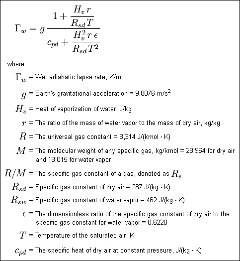
The wet adiabatic lapse rate can be mathematically expressed as:Environmental lapse rate
The dry adiabatic lapse rate and the wet adiabatic lapse rate are both theoretical rates. The actual real-world profile of temperature versus altitude that exists at any given time and in any given geographical location is called the environmental lapse rate, also often referred to as the ELR, prevailing lapse rate or ambient lapse rate.Meteorologists measure vertical temperature profiles by releasing weather balloons with mini-weather stations attached to them called radiosondes. Sometimes, meteorologists drop these mini-weather stations from an airplane at high altitude with a parachute attached. This type of measuring device is called a dropsonde.
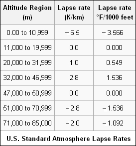
In general, the ambient atmospheric air in the troposphere decreases with increasing altitude and so the environmental lapse rate is denoted as being negative. A committee consisting of 29 organizations and universities in the United States, established an average environmental lapse rate named the U.S. Standard Atmosphere having various values, as shown in the adjacent table, which are dependent on the altitude region of Earth's atmosphere. From the Earth's surface to an altitude of 11 kilometres, the value of the U.S. Standard Atmosphere is – 6.5 K / km (3.57 °F / 1000 feet).
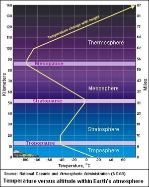
A number of other organizations have established "Standard Atmospheres", including the International Civil Aviation Organization (ICAO), the International Organization for Standardization (ISO) and the World Meteorological Organization (WMO), all three of whom agree with the U.S. Standard Atmosphere for altitudes up to 11 km (6.8 miles)The adjacent graph, published by the U.S. National Weather Service (NWS), depicts the average profile of temperature versus altitude in the various layers of the Earth's atmosphere. As can be seen, it is generally in fair agreement with the above tabulated lapse rates of the U.S. Standard Atmosphere.At times, inversion layers may form in the troposphere. Such inversion layers will have a positive environmental lapse rate, meaning that the atmospheric temperature increases with altitude within the inversion layers. An inversion layer may be one of two types:
Surface inversion layer
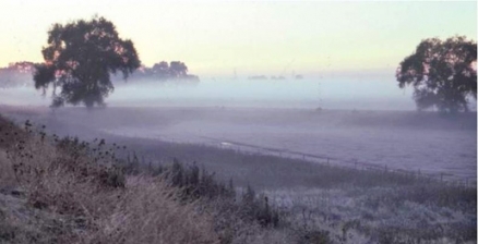
During the night, the Earth's surface loses heat rather rapidly by radiation while the ambient air above the surface loses heat more slowly by convection. Thus, what is called a radiation inversion forms in which the air temperature for some distance above the ground is higher than the air temperature very near to the ground. In other words, the environmental lapse rate within the surface inversion layer is positive and increases with altitude. Air very near Earth's surface which has flowed across a cold surface (such as a lake), and been cooled by advection, may also form a surface inversion layer called an advective inversion. Advection is a meteorological term for heat transfer occurring from horizontal air motion.
Inversion aloft
During a typical diurnal pattern (i.e., daily cycle), the base of a radiation inversion formed during the night rises during the day as the Earth's surface warms up from solar radiation. As it rises, it forms what is called an inversion aloft. The base of that inversion aloft is a ceiling or lid, above which very little or essentially no vertical turbulence (i.e., vertical motion) or vertical mixing occurs within the inversion layer. The height of the lid is called the mixing height. As the day goes on and the Earth's surface continues to warm, the base of the inversion rises, the inversion layer gets thinner and the mixing height increases. When the base of the layer reaches the inversion top, perhaps by mid-afternoon on a hot summer day, the inversion aloft breaks up completely and the mixing height is no longer limited.
Lapse rates and atmospheric stability
Atmospheric stability is a term used to qualitatively describe the amount of vertical motion of the air in the lower atmosphere (the troposphere). In broad general terms, the atmospheric stability can be characterized by these four categories:- A very stable atmosphere is one that has very little, if any, vertical motion of the air.
- A stable atmosphere is one that discourages vertical motion but does have some motion of the air.
- An unstable atmosphere is one that encourages continual vertical motion of the air, upwards or downwards.
- A neutral atmosphere is one that neither discourages nor encourages vertical motion of the air and is often referred to as conditionally stable.
The numerical value of the environmental lapse rate determines the stability category of the atmospheric air. Referring to the adjacent diagram:
- When the environmental lapse rate (i.e., the actual ambient temperature gradient) is greater than zero (as for the rate marked 1 in the adjacent diagram), then an inversion layer is present and the atmospheric temperature increases with altitude. There is essentially no vertical turbulence and the atmosphere is said to be very stable or extremely stable.
- When the environmental lapse rate is greater than – 5.5 K / km (as for the rate marked 2 in the diagram), then there is some small amount of vertical turbulence and the atmosphere is said to be stable. It may also be referred to as being sub-adiabatic.
- When the environmental lapse rate lies between the wet adiabatic lapse rate and the dry adiabatic lapse rate (as for the rate marked 3 in the diagram), then the atmosphere is said to be neutral. That would apply to the U.S. Standard Atmosphere of – 6.5 K / km in most cases.
- When the environmental lapse rate is less than the dry adiabatic lapse rate (as for the line marked 4 in the diagram), then there is turbulence in the atmosphere and the atmosphere is said to be unstable. It may also be referred to as being super-adiabatic.
- Although not shown in the diagram, if the environmental lapse rate were zero (perfectly vertical), then the atmosphere would be in an isothermal condition (no change of temperature with altitude) and would be also be said to be very stable.
Importance of understanding atmospheric stability
An understanding and knowledge of atmospheric stability is important for many reasons. What follows is a brief discussion of some of those reasons:
Probably one of the most important reasons is that atmospheric turbulence and mixing plays a major role in air pollution dispersion modeling. Turbulence and mixing is provided by an unstable atmosphere and thus enhances the dispersion of air pollutants, while a stable atmosphere inhibits turbulence and results in very poor dispersion of air pollutants.
A stable atmosphere inhibits rainfall, while an unstable atmosphere encourages rainfall and thunderstorms. A stable atmosphere also inhibits forest fire activity and an understanding of atmospheric stability helps explain certain aspects of forest fire behavior.
A certain amount of atmospheric instability is important for glider pilots, since without it the thermals needed for glider flight would not form. Understanding of atmospheric stability is also important for the safety of glider pilots because high atmospheric instability may lead to thunderstorms.
The atmospheric stability has a large impact on the deposition and drift of aerially applied sprays of various farm crop protection materials and herbicides.
Notes
- Note: File:F4d32bb17bfd12c85872de9df3570bb9.png is the LaTeX rendition of the Greek capital letter Gamma and Γ is the HTML rendition.
- Note: The lapse rate is often defined as the negative change of temperature with a change of altitude. That definition leads to statements such as "A positive lapse rate indicates cooling as height increases while a negative lapse rate indicates warming as height increases". That is counter-intuitive since lapse rates are usually denoted as a negative number (i.e., – 6.5 °K / kilometer (km) or the equivalent 3.6 °F / 1000 feet) to indicate cooling with an increase of height.
- Note: Since the wet adiabatic lapse rate may be as low as – 4 °K / km, the U.S. Standard Atmosphere may not always lie between the wet and dry adiabatic lapse rates.
References
- Lapse rates and air parcels, Professor Robert Fovell, Department of Atmospheric and Oceanic Science, University of California, Los Angeles.
- Characteristics of Air Parcels and Air Masses; Clouds, Dr. Nicholas Short, National Aeronautics and Space Administration (NASA).
- U.S. Standard Atmosphere, 1976.
- Vertical Motion and Atmospheric Stability, From the website of the U.S. Environmental Protection Agency.
- About Atmospheric Stability, Steve W. Woodruff, Pierce College, Los Angeles, California.
- John E. Frederick (2008), Principles of Atmospheric Science, 1st Edition, Jones and Bartlett, ISBN 0-7637-4089-6.
- Glossary of Meteorology (Atmospheric lapse rate) , Dry adiabatic lapse rate from the glossary of the American Meteorological Society.
- Glossary of Meteorology (Atmospheric lapse rate) 2, Moist adiabatic lapse rate from the glossary of the American Meteorological Society.
- Milton R. Beychok (2005), Fundamentals of Stack Gas Dispersion, 4th Edition. Author-published. ISBN 0-9644588-0-2., 4th Edition, Self-published, ISBN 0-9644588-0-2.
- Manual of the ICAO standard atmosphere extended to 80 kilometres (50 miles), Document 7488-CD, Third Edition, 1993.
- Standard Atmosphere, ISO 2533:1975/Add2:1997.
- The Layers of the Atmosphere From the website of the National Oceanic and Atmospheric Administration (NOAA) and the National Weather Service (NWS).
- Atmospheric Stability and Instability, From the website of the Utah State University.
- Atmospheric Stability, From the website of www.coursework.info
- Atmospheric stability, From the website of the Encyclopedia of Southern Fire Science (ESFS).
- Federal Aviation Administration (2007), Glider Flying Handbook, Reprint Edition, Skyhorse Publishing, ISBN 1-60239-061-4.
- Role of Atmospheric Stability in Drift and Deposition of American Society of Agricultural and Biological Engineers.


2 Comments
C Michael Hogan wrote: 02-20-2013 07:56:29
Now defined in text as Kelvin. Thanks for your interest in this article.
Victor Daduxing wrote: 02-19-2013 21:00:37
Hi. Please explain me something. I'm from Europe and i'm not familiar with some abbreviations from this article. What K means? Kelvin, celsius? For instance in the second paragraph. Or in the wet adiabatic section, the first paragraph Thank you