Area de Conservación Guanacaste, Costa Rica
Contents
- 1 Introduction Area de Conservación Guanacaste (ACG) (10°44' -11°06'N and 85°15' -86°00'W) in Costa Rica (Area de Conservación Guanacaste, Costa Rica) is a World Heritage Site.
- 2 Geographical Location
- 3 Date and History of Establishment
- 4 Area
- 5 Land Tenure
- 6 Altitude
- 7 Physical Features
- 8 Climate
- 9 Vegetation
- 10 Fauna
- 11 Cultural Heritage
- 12 Local Human Population
- 13 Visitors and Visitor Facilities
- 14 Scientific Research and Facilities
- 15 Conservation Value
- 16 Conservation Management
- 17 IUCN Management Category
- 18 Further Reading
Introduction Area de Conservación Guanacaste (ACG) (10°44' -11°06'N and 85°15' -86°00'W) in Costa Rica (Area de Conservación Guanacaste, Costa Rica) is a World Heritage Site.
Geographical Location
Located in northwestern Costa Rica, the site's boundaries start 12 miles out into the Pacific Ocean and extend inland across the Pacific coastal lowlands, over three tall volcanoes and down into the Atlantic coastal lowlands, for a distance of about 105 kilometers (km). The ACG covers much of the rectangle defined by the co-ordinates 10°44' -11°06'N and 85°15' -86°00'W.
Date and History of Establishment
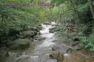 A stream at Rincon de la Vieja. (Source: Marietta College)
 - 1971: Santa Rosa National Park created by Executive Decree 1562-A/71;
- 1974: Rincón de la Vieja National Park established by Law 5398/74;
- 1989: Guanacaste National Park established by Executive Decree 19124-MIRENEM/89;
- 1989: Area de Conservación Guanacaste (ACG) frirst designated as such by Executive Decree 20516-MIRENEM (16 August 1989);
- 1995: Bahia Junquillal National Wildlife Refuge, which was created by Executive Decree 23867-MIRENEM/95;
- 1994: Area de Conservación Guanacaste formally declared to be part of the National System of Conservation Units (SINAC) by Executive Decree 22909 (7 February 1994);
- 1999: Area de Conservación Guanacaste inscribed as a World Heritage site.
- 2004: Santa Elena Sector (SES) proposed (and accepted) to be included in the Area de Conservación Guanacaste, following the successful resolution of the international expropriation case (ICSID Case No. ARB96/1) between the private land owners of Santa Elena Sector and the State of Costa Rica.
Area
The total area of the Area de Conservación Guanacaste (ACG) (as of 2004) comprises 147,000 hectares (ha), comprising 104,000 terrestrial habitats and 43,000 marine habitats.
Land Tenure
The Government of Costa Rica owns most of the land, except for a portion of the corridor Pitilla-Orosi-Cacao, which is still owned by the Fundación de Parques Nacionales (FPN), a parastatal nongovernmental organization (NGO). In 1999 two additional small areas were being negotiated for purchase by the state, it is unclear whether this was successful.
Altitude
Ranges from sea level to 1,916 [[meter]s (m) at the summit of Volcan Rincon de la Vieja.
Physical Features
The site comprises the Guanacaste Cordillera and surrounding flatlands and coastal areas. The ACG includes a series of volcanoes, the most notable being Rincon de la Vieja, which has three craters (each one displaying collapse characteristics) and one lagoon. The last eruption was observed in the 1970's, but some fumarole activity still occurs in one of the craters. In the base of the volcano are several minor craters or pailas (from 0.5 m to 10 m in diameter) with mud in ebullition. At least 32 rivers and 16 intermittent streams originate in the vicinity of the volcano, and flow into the Tempisque, a river of enormous importance for irrigation of agricultural land in the Guanacaste Province. Volcanic rock of high calcium carbonate underlies the western region; sedimentary sandstone occurs on the coastal flank. Salt flats or "salinas" are found along littoral lowlands.
Punta Respingue, approximately 75 ha and located in the coastal area of the Santa Elena Sector (SES), is the only freshwater wetland on the entire Pacific coast of Costa Rica, formed by eroded alluvial soil washed down from the soils behind. It forms a swamp in the rainy season with an area of open water.
The marine area includes various near shore islands and islets (mostly uninhabited), open ocean marine zones, beaches, dune systems (highest and most dense occur at SES), rocky coasts, raised cobble beaches (SES) and approximately 20 km of sea turtle nesting beaches. More specific surface habitats include coral reefs, rocky reefs, sandy bottoms, rock fields, deep water, algal beds and upwelling currents. The ACG possesses, among other marine features, a beach (Nancite) of 1.7 km length, where thousands of olive ridley sea turtles nest simultaneously in major waves, called "arrivals", or "arribadas" in Spanish. This is one of the few protected arribada beach for this species in all of Mexico and Central America. Also, the ACG contains two nesting beaches of the highly threatened Leather Back sea turtle.
Climate
Tropical hot with a rainy season running from May to November. The average annual precipitation is 1,528 millimeters (mm) in the Santa Rosa sector of the ACG, with considerable variation in the amount of rainfall each year. The mean annual temperature is 28 degrees Celsius (°C,) again measured in the weather station of the Santa Rosa sector. The hottest months are April and May.
Vegetation
The following Holdridge (1967) Life Zones occur within the approximate boundaries of the nominated World Heritage Site: Dry; Humid Tropical; Premontane Very Humid; Humid Tropical Transition to Premontane; Premontane Rain; Lower Montane Rain; and Very Humid Tropical Transition to Premontane. The core Dry Forest zone of about 60,000 ha is an outstanding complex of vegetation types and 20 distinct plant associations growing on different soil types (e.g. limestone, alluvial, recent volcanic, ancient volcanic, serpentine), slopes and exposures to the trade winds. Main vegetation types include: (a) mixed deciduous forest with Calycophyllum candidissimum, Bombacopsis quinatum and Luehea candida among the dominants, and with fig trees Ficus sp. and rosewood Dalbergia retusa also represented; (b) evergreen gallery forests along streams and behind the occasionally flooded zone (estero); (c) savannas with exotic jaragua grass Hyparrhenia rufa and scattered trees of Byrsonima crassifolia and Curatella americana; (d) oak forests and savannas with Quercus oleiodes dominant; and (e) mangroves Rhizophora mangle, Avicennia nitida, Conocarpus erectus and Laguncularia racemosa. There is also beach vegetation, and areas of calabash Crescentia sp. forest.
The intact altitudinal transect contained within the ACG protects an entire elevational and east-west seasonal migratory route from the Pacific coast to 2,000 m above sea level, from dry forest to cloud forest and down to Atlantic rain forest, which is critical for the range and life histories of many species of animals.
In the area of Volcan Rincon de la Vieja, four different forest types are present: (a) Tropical Wet with Quercus spp. (in the poor and eroded soil), Spondias spp., Achras sapota, Cedrela adorata, Rhedia edulis and Enterolobium cyclocarpum are common species; (b) Premontane Moist, which is very rich in species; (c) Premontane Rain with very rough topography; and (d) Lower Montane Rain where stands of Clusia spp. occur, sometimes mixed with a few other species (including palms). This forest is covered by clouds all year and the trees are dwarfed because of prevailing strong winds and sandy [[soil]s].
The ACG contains 37 wetland areas, among which are included major ones for Central America such as Puerto Soley, Cuajiniquil, Santa Elena, Potrero Grande, Nancite and Playa Naranjo mangrove complexes; Limbo Lagoon; Iguanito Estuary; and, Rincon de la Vieja Volcano Lagoon (freshwater in this last case). ). ACG as a whole supports significant areas of mangrove forests (containing eight species) that are exceptionally intact.
Fauna
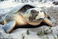 During mating season, over 250,000 turtles nest on the Naranjo and Nancite beaches, the majority of them being the Olive Ridley turtle (Lepidochelys olivacea). (Source: University of Florida)
 The inventory of vertebrates, insects and aquatic biota that exist in the nominated World Heritage Site has been ongoing since 1973. For instance, more than two million pinned and labeled insects from the area are deposited in the collections of the National Institute of Biodiversity (INBio). The ACG contains a very diverse fauna with several species of conservation concern. Some notable mammals are white?tailed deer Odocoileus virginianus, white?lipped peccary Tayassu pecary, collared peccary Tayassu tajacu, Central American tapir Tapirus bairdii (VU), white?face monkey Cebus capucinus and spider monkey Ateles geoffroyi, howler monkey Alouatta palliata, collared anteater Tamandua tetradactyla, jaguar Panthera onca (VU), margay Felis wiedii (VU), jaguarundi F. yagouaroundi and ocelot F. pardalis (VU).
The avifauna is well represented in the area with more 500 species. Among the bird species the following are the commonest: military macaw Ara militaris (VU), rufescent tinamu Crypturellus cinnamomeus, spot?bellied bobwhite Colinus leucopogon, great curassow Crax rubra, crested guan Penelope purpurascens, blue?winged teal Anas discors, roseate spoonbill Ajaia ajaja, thick knee Burhinus bistriatus, jabiru Jabiru mycteria (VU), ibis Eudocimus albus and laughing falcon Herpetotheres cachinans. In the estuaries small individuals of Caiman crocodylus and Crocodylus acutus have been observed. On the Naranjo and Nancite beaches during the breeding and mating season (August to December), over 250,000 turtles arrive to nest. The majority of them are olive ridley turtle Lepidochelys olivacea (EN). The green turtle Chelonia mydas (EN), leatherback turtle Dermochelys coriacea (EN) and hawksbill turtle Eretmochelys imbricata (CR) also use the beaches quite extensively to nest. The ACG is estimated to possess 12,000 species of nematodes, 20,000 species of Coleoptera (beetles) and 13,000 species of Hymenoptera (ants, bees, wasps and relatives).
Cultural Heritage
The Hacienda Santa Rosa was established in 1580-1600 and was one of the first and most important cattle ranches of the region. In 1856 it was the site of the "Battle of Santa Rosa". The House ('Casona') of the Hacienda has become the historical landmark of the successful 'Campaign of 56?57' in which Costa Rica upheld her independence. Between then and the time of the declaration of the Casona (and 1,000 surrounding hectares) as a national monument in 1966, all or some portion of the Santa Rosa sector has had more than 40 different owners. Apparently, Hacienda Santa Rosa was initially used to breed mules, which were used for transporting goods across the Central American isthmus. Then, its pastures became the food for cattle that was used to feed the people working in the Indigo plantations from Nicaragua to Guatemala.
Local Human Population
The ACG is located in the Guanacaste Province near to the international border with Nicaragua. No information on economic activities and human population was provided.
Visitors and Visitor Facilities
The Administrative Area is located in the Santa Rosa sector (which used to be Santa Rosa National Park), whose entrance is 35 km northwest of the city of Liberia or 24 km to the south of La Cruz, following the International Highway. The Santa Rosa National Park has become one of the most heavily visited natural areas in Costa Rica, with the visitation largely concentrated on the historic Casona, the beach at the Naranjo and Nancite sectors with its spectacular "arribadas" of olive ridley turtle. Around 64,000 tourists visited the region in 1997, half of them being nationals. Visitors to individual protected areas are charged with an entrance fee of US$15 for foreign tourists and US$2 for nationals. The Santa Rosa sector has some facilities for visitors, but most of them are located in nearby localities and the city of Liberia, which is located some 50 km east of the entrance to the Santa Rosa National Park.
Scientific Research and Facilities
Corcovado National Park and Santa Rosa National Park are the two protected areas most used by national and international researchers in Costa Rica. Research has been dealing with local fauna, savanna succession and effects of fire, and behavior and ecology of the vertebrate fauna, notably the ridley turtle. Appendix 1 of the nomination for inclusion of the site on the World Heritage List includes a partial list of published material about the ACG ecosystems, habitats, organisms and processes. New publications about the ACG biodiversity are now accumulating at a rate of about 100 per year.
Conservation Value
The nominated World Heritage Site contains may be the largest well-preserved and well-represented sample of the highly endangered tropical dry forest in the Neotropics and includes entire watersheds, adjacent areas of cloud forest and coastal/marine interfaces. This 105 km long transect also contains sufficient elevation and climatic diversities to include a wide range of migratory and vagrant species. The ACG also includes the [[population]s] of at least 60% of the species of terrestrial and freshwater organisms in Costa Rica.
Conservation Management
The overall objective of the ACG is to maintain into perpetuity the biodiversity and related ecosystems that exist in the region. A major means for this is the promotion and implementation of non-damaging development practices by all sectors of society under the strict control and surveillance of the staff of the ACG. The modus operandi of the ACG is throroughly described in the new Biodiversity Law No. 7788/1998, which establishes both the SINAC and the Conservation Areas. In order to achieve its objective the ACG undertakes the following actions: (a) the inclusion of the few remaining marginal wild lands; (b) the development of non-damaging environmental services to be offered locally, nationally and internationally; (c) the continuation of ongoing efforts to understand the biology, location and functions of the local diversity of species and ecosystems; and (d) the implementation of programs of outreach at all levels.
The AGC management plan consists of a several-hundred page document, which is being reviewed and updated each year by the AGC programs to accompany their annual budget statement. Activities to be carried out are developed by each of the different AGC programs, according to the specific needs at that time, all in the context of carrying out the four actions described in the previous paragraph. These annual management plan and budget are generated and approved at first instance by the ACG itself, followed by discussion and approval by the Regional Council, and the approval by SINAC/MINAE.
Management Constraints
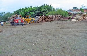 Logging in Costa Rica damages the ecosystem. (Source: Marietta College)
 The AGC is an area that has been subjected to about four centuries of highly heterogeneous, sporadic and irregular damage from anthropogenic fires, lumbering, ranching, farming and other perturbation types (e.g. re-channelling water for irrigation, a sulfur mine, introduction of African grasses, road construction, selective fence-post collection, application of pesticides, etc.). As an example, in its early ages the AGC contained from 50,000 ha to 60,000 ha of marginal pastures in various degrees of recuperation. However, due to the type of [[soil]s], irregular climate seasonality, relative isolation from the [[Costa Rica]n] centers of power and foreign ownership of the land, none of the above mentioned damages were sufficiently extensive as to render the natural ecosystems impossible to restore.
Harvests of traditional products (snapper mainly, sometimes crabs and other species) by local fisherman are showing decreases in sizes of individual animals and increases in effort required for the same catch. Moreover, outside fishing interests (mainly shrimpers for Punta Arenas, Costa Rica) are causing damage by use of small-mesh nets and resulting capture of a vast array of species which are simply dumped. Conflicts between outside fishing interests and local fishermen are growing. The ACG has established good relations with local fishermen and has started a program of applied research and participation with them. However, these are complex social-economic-ecological problems and trends, without easy prescribed formulas for solution; they are cutting edge.
Staff
The AGC represents the consolidation of government-owned national parks, forest reserves, wildlife refuges and recently purchased private properties into one cohesive administrative unit, which employs 120 people.
Budget
The financial management of the AGC is based on the allocation of the income generated by an endowment fund (US$12-13 million), which is legally held and invested by FPN in co-ordination with the ACG and other investors. This fund was established in 1987-1989 through a debt-for-nature swap by the Swedish Government, the Costa Rican Central Bank, FPN and the Ministry of the Environment and Energy (MINAE). The area also generates income from the provision of environmental services and from grants to specific projects. Financial assistance from the government is largely restricted to specific activities. The total budget allocated in 1998 was US$1.7 million.
IUCN Management Category
- Rincón de la Vieja National Park II (National Park)
- Santa Rosa National Park II (National Park)
- Guanacaste National Park II (National Park)
- Bahia Junquillal National Wildlife Refuge IV (Habitat/Species Management Area)
- National World Heritage Site (inscribed 1999) - Criteria i, ii, iii, iv
Further Reading
More than 600 references are cited in the official nomination, of which the most important are the following:
- ACG (1998a). Regulations for visitors to Playa Nancite. ACG, 1998. 3pp.
- ACG (1998b). Plan de Operaciones Annual, Area de Conservación Guanacaste, 1998.
- Behler, J.L., Pritchard, P.C.H. and Rhodin, A.G.J. (Eds.) (1996). The leatherback turtle, Dermochelys coriacea. Chelonian Conservation and Biology. International Journal of Turtle and Tortoise Research 2:139-324.
- Boza, M.A. (1992). Costa Rica National Parks. INCAFO, Madrid. 91pp. ISBN: 848912745X.
- Bussing, W., Winemiller, K., Lopez, M., Bolaños, F., Sasa, M., Donnelly, M., Savage, J., Guyer, C., Solorzano, A., Araya, M., Barrantes, G., Blake, J., Hernández, D., Joyce, F., Loiselle, B., Pereira, A., Mora, J.M., Rodriguez, B., Collado, L.M., Saenz, J., Salazar, J., Vega, V.A. and Yates, T. (1996). An inventory of the vertebrate fauna of the Guanacaste Conservation Area. 123pp.
- Cornelius, S.E. (1986).The sea turtles of the Santa Rosa National Park. Fundación de Parques Nacionales, San José, Costa Rica. 64pp. ISBN: 8459911012.
- García, R. (1996). Propuesta técnica de ordenamiento territorial con fines de conservación de biodiversidad en Costa Rica: Proyecto GRUAS. SINAC, MINAE, San Jose, Costa Rica. 114pp.
- Government of Costa Rica (1998). Nomination of properties for the inclusion of Guanacaste Conservation Area on the World Heritage List. 44 pages + Annex.
- IUCN (1996). 1996 IUCN Red List of Threatened Animals. IUCN, Gland, Switzerland. 368 pp. + annexes. ISBN: 2831703352.
- Janzen, D.H. (1983). Costa Rican Natural History. University of Chicago Press, Chicago, USA. 816pp. ISBN: 0226393321.
- Janzen, D.H. (1987). How to grow a tropical national park: basic philosophy for Guanacaste National Park, northwestern Costa Rica. Experientia 43:1037-1038.
- Janzen, D.H. (1988). Guanacaste National Park: Tropical ecological and biocultural restoration. In Cairns, J.J. (Ed.) Rehabilitating damaged ecosystems Vol.II. CRC Press, Boca Raton, Florida:143-192. ISBN: B0006EOBIM.
- Janzen, D.H. and Gámez, R. (1997). Assessing information needs for sustainable use and conservation of biodiversity. In Hawksworth, P.M. and Dextre Clarke, S. (Eds.) Biodiversity Information: Needs and options. CAB International, Wallingford, Oxon, UK:21-29.
 Image from Wikimedia Commons
| Disclaimer: This article is taken wholly from, or contains information that was originally published by, the United Nations Environment Programme-World Conservation Monitoring Centre (UNEP-WCMC). Topic editors and authors for the Encyclopedia of Earth may have edited its content or added new information. The use of information from the United Nations Environment Programme-World Conservation Monitoring Centre (UNEP-WCMC) should not be construed as support for or endorsement by that organization for any new information added by EoE personnel, or for any editing of the original content. |