Anguilla
| Topics: |
Countries and Regions of the World Collection  Anguilla is a British overseas territory of approximately 15,000 people in the Caribbean, one of the most northerly of the Leeward Islands in the Lesser Antilles.
It consists of the main island of Anguilla itself, approximately 26 km (16mi) long by 5 km (3.1mi) wide at its widest point, together with a number of much smaller islands and cays with no permanent population.
|
|
|
|
|
|
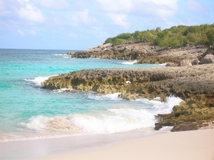
| Anguilla, one of the Leeward Islands in the Caribbean, is composed of scrub-covered coral and limestone, which can be seen in this photograph of Limestone Bay. The island's many bays and pristine beaches draw visitors from around the world, making tourism Anguilla's main industry. |
|
|
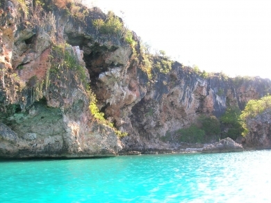
| A popular spot for snorkeling, Little Bay is a secluded cove only accessible by boat. Anguilla is home to many ecologically important coral reefs and beaches. |
|
|
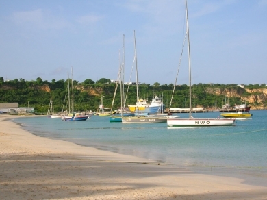
| The village of Sandy Ground is Anguilla's main port and harbor. It contains a large salt pond that is part of Anguilla's salt industry. While Anguilla's salt resources are smaller than other area islands, it benefits from its more accessible location for shipping. |
|
|
| Sailboats at Sandy Ground before the annual Carnival Boat Race. Every year Anguilla holds a two-week-long celebration of Emancipation Day (beginning of August). While the island hosts many boat races throughout the year, the Champion of Champions Race during this celebration is the culminating event. Boaters from many neighboring islands, as well as from Anguilla, start in Sandy Ground and end in Island Bay. Spectators, nicknamed landracers, gather on the beaches to watch and picnic. |
|
|
| The land mass seen across Rendezvous Bay is the island St. Martin, which is separated from Anguilla by the Anguilla Channel. Rendezvous Bay houses the longest beach in Anguilla and is the site of the Battle of Anguilla. The engagement took place during the Napoleonic Wars; the French were dispatched from St. Martin and landed on the beach of Rendezvous Bay. The invaders destroyed Anguilla's plantations, which by 1821 had almost entirely disappeared from the island. Although, the French were eventually routed by the British, the island's plantations never recovered, forcing many Anguillans into maritime occupations. |
|
|
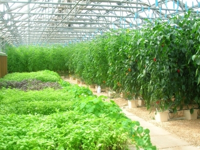
| Soil on the island is of poor quality making it difficult to grow most crops locally. The CuisinArt Resort at Rendezvous Bay has a 1,670 sq m (18,000 sq ft) hydroponics farm, unique to the Caribbean. The greenhouses are built to withstand 177 kmph (110 mph) winds, common during hurricane season. The farm grows vegetables, lettuce, and a variety of herbs. |
|
|
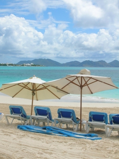
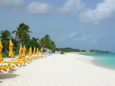
| Shoal Bay beach is a popular choice of tourists and is located on the northern coast of the island. |
|
|
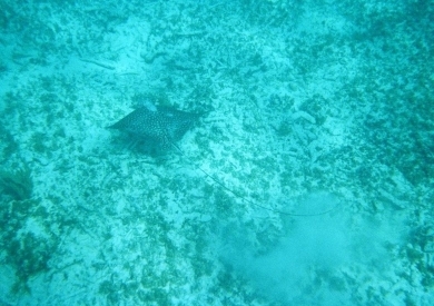
| A stingray in Shoal Bay. Snorkeling is a popular activity around the island due to the presence of many reefs teeming with wildlife. |
|
|
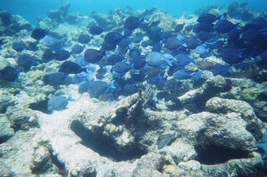
| A school of fish parades before a coral mount in Shoal Bay. |


Colonized by English settlers from Saint Kitts in 1650, Anguilla was administered by Great Britain until the early 19th century, when the island - against the wishes of the inhabitants - was incorporated into a single British dependency, along with Saint Kitts and Nevis.
Several attempts at separation failed. In 1971, two years after a revolt, Anguilla was finally allowed to secede.
This arrangement was formally recognized in 1980, with Anguilla becoming a separate British dependency.
Its major environmental issues include supplies of potable water sometimes cannot meet increasing demand largely because of poor distribution system.
Contents
Geography
Location: Caribbean, islands between the [[Caribbean] Sea] and North Atlantic Ocean, east of Puerto Rico
Geographic Coordinates:18 15 N, 63 10 W
Area: 102 sq km -mostly rock with sparse scrub oak, few trees, some commercial salt ponds (2005)
Coastline:61 km
Maritime Claims:
territorial sea: 3 nm
exclusive fishing zone: 200 nm
Natural Hazards:frequent hurricanes and other tropical storms (July to October)
Terrain:flat and low-lying island of coral and limestone. The highest point is Crocus Hill (65 m)
Climate: tropical; moderated by northeast trade winds.
Ecology and Biodiversity
See Biological diversity in the Caribbean Islands.
Most of the island is included within the Caribbean shrublands ecoregion.
Leeward Islands dry forests covers small portions of the Caribbean’s Leeward Islands. It is commonly found as a mid-gradient forest type between the xeric coastal regions and the higher-relief inner-island moist forests. It includes small coastal areas on Anguilla and Antigua.
Government
Government Type: (overseas territory of the UK)
Capital:The Valley (population: 2,000; 2009)
Legal System: based on English common law
People and Society
Population: 15,423 (July 2012 est.)
Ethnic Groups: black (predominant) 90.1%, mixed, mulatto 4.6%, white 3.7%, other 1.5% (2001 census)
Age Structure:
0-14 years: 24% (male 1,861/female 1,764)
15-64 years: 68.1% (male 4,855/female 5,427)
65 years and over: 7.9% (male 577/female 610) (2011 est.)
Population Growth Rate: 2.146% (2012 est.)
Birthrate: 12.9 births/1,000 population (2012 est.)
Death Rate: 4.41 deaths/1,000 population (July 2012 est.)
Net Migration Rate: 12.97 migrant(s)/1,000 population (2012 est.)
Life Expectancy at Birth: 80.98 years
male: 78.42 years
female: 83.63 years (2012 est.)
Total Fertility Rate: 1.75 children born/woman (2012 est.)
Languages:English (official)
Literacy: (age 12 and over can read and write): 95% (1984 est.)
Water
Acceess to improved drinking water sources: 60% of population
Access to improved sanitation facilities: 99% of population
Economy
Anguilla has few natural resources, and the economy depends heavily on luxury tourism, offshore banking, lobster fishing, and remittances from emigrants.
Increased activity in the tourism industry has spurred the growth of the construction sector contributing to economic growth.
Anguillan officials have put substantial effort into developing the offshore financial sector, which is small but growing.
In the medium term, prospects for the economy will depend largely on the tourism sector and, therefore, on revived income growth in the industrialized nations as well as on favorable weather conditions.
GDP: (Purchasing Power Parity): $175.4 million (2009 est.)
GDP: (Official Exchange Rate): $175.4 million (2009 est.)
GDP- per capita (PPP): $12,200 (2008 est.)
GDP- composition by sector:
Industries: tourism, boat building, offshore financial services
Currency: East Caribbean dollars (XCD)