Wind (Weather & Climate)
Contents
Wind
| Topics: |
Introduction Figure 1: Formation of wind as a result of localized temperature (Wind) differences. (Source: PhysicalGeography.net)
Wind can be defined simply as air in motion. This motion can be in any direction, but in most cases the horizontal component of wind flow greatly exceeds the flow that occurs vertically. The speed of wind varies from absolute calm to speeds as high as 380 kilometers per hour (Mt. Washington, New Hampshire, April 12, 1934). In 1894, strong winds in Nebraska pushed six fully loaded coal cars over 160 kilometers in just over three hours. Over short periods of time surface winds can be quite variable.
Wind develops as a result of spatial differences in atmospheric pressure. Generally, these differences occur because of uneven absorption of solar radiation at the Earth's surface (Figure 1). Wind speed tends to be at its greatest during the daytime when the greatest spatial extremes in atmospheric temperature and pressure exist.

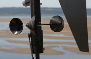
Wind is often described by two characteristics: wind speed and wind direction. Wind speed is the velocity attained by a mass of air traveling horizontally through the atmosphere (Atmosphere layers). Wind speed is often measured with an anemometer in kilometers per hour (kmph), miles per hour (mph), knots, or meters per second (mps) (Figure 2). Wind direction is measured as the direction from where a wind comes from. For example, a southerly wind comes from the south and blows to the north. Direction is measured by an instrument called a wind vane (Figure 2). Both of these instruments are positioned in the atmospheric environment at a standard distance of 10 meters above the ground surface.
Wind speed can also be measured without the aid of instruments using the Beaufort wind scale (Table 1). This descriptive scale was originally developed by Admiral Beaufort of the British Navy in the first decade of the 17th century. The purpose for this system was to allow mariners to determine wind speed from simple observations. The Beaufort system has undergone several modifications to standardize its measurement scale and to allow for its use on land. Users of this scale look for specific effects of the wind on the environment to determine speed.
| Table 1: Beaufort wind speed scale. | ||||
|---|---|---|---|---|
| Beaufort Code |
Speed Miles per Hour |
Speed Kilometers per Hour |
Description | Effects on the Environment |
| 0 | < 1 | < 1 | calm | smoke rises vertically |
| 1 | 2 - 3 | 1 - 5 | light air | smoke drifts slowly |
| 2 | 4 - 7 | 6 - 11 | light breeze | leaves rustle, wind can be felt, wind vanes move |
| 3 | 8 - 12 | 12 - 19 | gentle breeze | leaves and twigs on trees move |
| 4 | 13 - 18 | 20 - 29 | moderate breeze | small tree branches move, dust is picked up from the ground surface |
| 5 | 19 - 24 | 30 - 38 | fresh breeze | small trees move |
| 6 | 25 - 31 | 39 - 51 | strong breeze | large branches move, telephone and power overhead wires whistle |
| 7 | 32 - 38 | 51 - 61 | near gale | trees move, difficult to walk in the wind |
| 8 | 39 - 46 | 62 - 74 | gale | twigs break off from trees |
| 9 | 47 - 54 | 75 - 86 | strong gale | branches break off from trees, shingles blown off roofs |
| 10 | 55 - 63 | 87 - 101 | whole gale | trees become uprooted, structural damage on buildings |
| 11 | 64 - 74 | 102 - 120 | storm | widespread damage to buildings and trees |
| 12 | > 75 | > 120 | hurricane | severe damage to buildings and trees |
Winds are named according to the compass direction of their source. Thus, a wind from the north blowing toward the south is called a northerly wind. Figure 3 describes the sixteen principal bearings of wind direction. Most meterological observations report wind direction using one of these sixteen bearings.

Horizontally, at the Earth's surface wind always blows from areas of high pressure to areas of low pressure (vertically, winds move from areas of low pressure to areas of high pressure), usually at speeds determined by the rate of air pressure change between pressure centers. This situation is comparable to someone skiing down a hill. The skier will of course move from the top of the hill to the bottom of the hill, with the speed of their descent controlled by the gradient or steepness of the slope. Likewise, wind speed is a function of the steepness or gradient of atmospheric air pressure found between high and low pressure systems. When expressed scientifically, pressure change over a unit distance is called pressure gradient force, and the greater this force the faster the winds will blow.

On weather maps, pressure is indicated by drawing isolines of pressure, called isobars, at regular 4 millibar intervals (e.g., 996 mb, 1000 mb, 1004 mb, etc.). If the isobars are closely spaced, we can expect the pressure gradient force to be great, and wind speed to be high (see Figure 4). In areas where the isobars are spaced widely apart, the pressure gradient is low and light winds normally exist. High-speed winds develop in areas where isobars are closer.
Driving Forces
To better understand wind we must recognize that it is the result of a limited number of accelerating and decelerating forces, and that the action of these forces is controlled by specific fundamental natural laws. Sir Isaac Newton formulated these laws as several laws of motion. The first law suggests that an object that is stationary will remain stationary, and an object in motion will stay in motion as long as no opposing force is put on the object. As a result of this law, a puck sent in flight from a blade of a hockey stick will remain in motion until friction slows it down or the goalie makes a save. This law also suggests that once in motion an object's path should be straight.
Newton's second law of motion suggests that the force put on an object equals its mass multiplied by the acceleration produced. The term "force" in this law refers to the total or net effect of all the forces acting on an object. Mathematically, this law is written as:

From this natural law of motion we can see that the acceleration of an object is directly proportional to the net force pushing or pulling that body and inversely proportional to the mass of the body. Thus, the greater the force created by the movement of a hockey player's stick the faster the puck will travel. This law also suggests that if the player used a larger (more massive) puck, more force would have to be applied to it to get it to travel as fast as a puck with less mass.
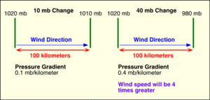
Pressure gradient force is the primary force influencing the formation of wind from local to global scales. This force is determined by the spatial pattern of atmospheric pressure at any given moment in time. Figure 5 illustrates two different pressure gradient scenarios and their relative effect on wind speed.
The two diagrams display the relative relationship between pressure gradient and wind speed. This relationship is linear and positive. As a result, quadrupling the pressure gradient increases wind speed by a factor of four. This is what we would expect according to Newton's second law of motion, assuming the mass of the wind is unchanged.
We can also describe pressure gradient acceleration mathematically with the following equation:
where:
- D = density of air (average density of surface air is 1.29 kilograms per cubic meter)
- P2 = pressure at point 2 in Newtons/m2 (N m-2)
- P1 = pressure at point 1 in Newtons/m2 (N m-2)
- n = distance between the two points in meters
From this equation we can determine wind acceleration between two points in meters per second squared by knowing three variables: the density of the moving air; the change in pressure (Atmospheric pressure) between the points of interest in newtons; and the distance between the two points in meters. For example, to determine the wind speed between two points for moving air with a density of 1.29 kilograms per cubic meter, a pressure difference of 400 Newtons/m2, and a distance of 300,000 meters, the following calculations would be performed:
From the calculated value of acceleration we can determine wind speed, V, from the formula:
Where Vo is the initial velocity of the wind and t is the time during which F is applied.

The rotation of the Earth creates another force, termed Coriolis force, which acts upon wind and other objects in motion in very predictable ways. According to Newton's first law of motion, air will remain moving in a straight line unless it is influenced by an unbalancing force. The consequence of Coriolis force opposing pressure gradient acceleration is that the moving air changes direction. Instead of wind blowing directly from high to low pressure, the rotation of the Earth causes wind to be deflected off course. In the Northern Hemisphere, wind is deflected to the right of its path, while in the Southern Hemisphere it is deflected to the left. The magnitude of the Coriolis force varies with the velocity and the latitude of the object. Coriolis force is absent at the equator, and its strength increases as one approaches either pole. Furthermore, an increase in wind speed also results in a stronger Coriolis force, and thus in greater deflection of the wind. Coriolis force only acts on air when it has been sent into motion by pressure gradient force. Finally, Coriolis force only influences wind direction and never wind speed.

Centripetal acceleration is the third force that can act on moving air. It acts only on air that is flowing around centers of circulation. Centripetal acceleration is also another force that can influence the direction of wind. Centripetal acceleration creates a force directed at right angles to the flow of the wind and inwards towards the centers of rotation (e.g., low and high pressure centers). This force produces a circular pattern of flow around centers of high and low pressure. Centripetal acceleration is much more important for circulations smaller than the mid-latitude cyclone.
The last force that can influence moving air is frictional deceleration. Friction can exert an influence on wind only after the air is in motion. Frictional drag acts in a direction opposite to the path of motion causing the moving air to decelerate (see Newton's first and second laws of motion). Frictional effects are limited to the lower one kilometer above the Earth's surface.
Geostrophic Wind
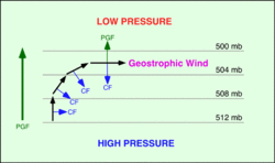
Air under the influence of both the pressure gradient force and Coriolis force tends to move parallel to isobars in conditions where friction is low (1000 meters above the surface of the Earth) and isobars are straight. Winds of this type are usually called geostrophic winds. Geostrophic winds come about because pressure gradient force and Coriolis force come into balance after the air begins to move (Figure 7).
Figure 7 models air flow in the Northern Hemisphere. In the Southern Hemisphere, Coriolis acceleration acts on moving air by deflecting it to the left instead of the right.
Finally, Buys Ballot's Law states that when you stand with your back to a geostrophic wind in the Northern Hemisphere, the center of low pressure will be to your left and the high pressure to your right. The opposite is true for the Southern Hemisphere.
Gradient Wind
Wind above the Earth's surface does not always travel in straight lines. In many cases winds flow around the curved isobars of a high (anticyclone) or low (cyclone) pressure center. A wind that blows around curved isobars above the level of friction is called a gradient wind. Gradient winds are slightly more complex than geostrophic winds because they include the action of yet another physical force. This force is known as centripetal force and it is always directed toward the center of rotation. The following figure describes the forces that produce gradient winds around high and low pressure centers (Figure 8). Around a low, the gradient wind consists of the pressure gradient force and centripetal force acting toward the center of rotation, while Coriolis force acts away from the center of the low. In a high pressure center, the Coriolis and centripetal forces are directed toward the center of the high, while the pressure gradient force is directed outward.
Friction Layer Wind
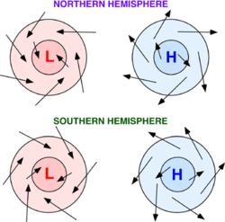
Surface winds on a weather map do not blow exactly parallel to the isobars as in geostrophic and gradient winds. Instead, surface winds tend to cross the isobars at an angle varying from 10 to 45°. Close to the Earth's surface, friction reduces the wind speed, which in turn reduces the Coriolis force. As a result, the reduced Coriolis force no longer balances the pressure gradient force, and the wind blows across the isobars toward or away from the pressure center. The pressure gradient force is now balanced by the sum of the frictional force and the Coriolis force. Thus, we find surface winds blowing counterclockwise and inward into a surface low, and clockwise and out of a surface high in the Northern Hemisphere. In the Southern Hemisphere, the Coriolis force acts to the left rather than the right. This causes the winds of the Southern Hemisphere to blow clockwise and inward around surface lows, and counterclockwise and outward around surface highs (see Figure 9).


