Western Himalayan broadleaf forests
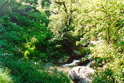
Great Himachal National Park, India (Photograph by G. S. Rawat)
Because the western Himalayas are drier than the eastern extent, the Western Himalayan Broadleaf Forests are less species-rich than their eastern counterpart. This ecoregion is nevertheless of regional conservation importance for its biodiversity and for its role as a critical link in the chain of Himalayan ecosystems that are layered along the steep south-facing slopes.
Several of the Himalayan birds and mammals that exhibit altitudinal seasonal migrations depend on contiguous habitat up and down the steep Himalayan slopes for unrestricted movements. If any of the habitat layers-which range from the alluvial savanna and grasslands in the Terai, through the broadleaf forests and conifers, to the alpine meadows in the high mountains-are lost or degraded, these processes will be disrupted.
The fact that several bird species known from the subtropical broadleaf forests to the south are expected to occur in this ecoregion but do not may result from the more advanced state of habitat fragmentation in these western Himalayan broadleaf forests, relative to the eastern broadleaf forests.
Habitat loss in these steep slopes will also compromise the ecological integrity and hydrology of the watersheds, with far-reaching consequences that will be felt in the Ganges delta thousands of kilometers (km) away.
Location and General Description
 Source: WWF
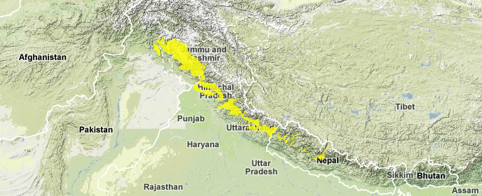
This ecoregion represents the temperate broadleaf forests of the western Himalayas, to the west of the Kali Gandaki River gorge in Nepal, through northern India's states of Uttar Pradesh and Himachal Pradesh, and into Jammu and Kashmir, with small sections extending into Pakistan. These temperate forests form a narrow east-west-directed band between 1,500 and 2,600 meters (m).
The Himalayan Mountain Range dates back 50 million years, to the period when the northward-drifting Deccan Plateau collided with the Eurasian continent and inexorably pushed the southern edge of Eurasia upward, raising it from beneath the Tethys Sea to create the Tibetan Plateau, which now lies at more than 4,000 m above sea level. During this and three subsequent periods of geologic upheaval and uplift, the Himalayan Mountains were thrust upward to form what is now the highest mountain range in the world. The Himalayas consist of three parallel ranges. The Outer Himalayas lie alongside the Indo-Gangetic Plain. The Middle Himalayas, a highly folded system of ridges and valleys, rise to about 5,000 m. The Inner Himalayas contain the highest mountain peaks in the world. This ecoregion lies along the middle Himalayas.
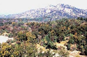 Rajaji National Park, Uttar Pradesh, India (Photograph by G. S. Rawat)
 The Himalayan Range receives most of its moisture from the southwestern monsoon that originates in the Bay of Bengal. The moisture-laden monsoon winds are funneled through the Gangetic Plains toward the mountain range, where most of the precipitation is intercepted by the eastern Himalayas. The western extent therefore receives less precipitation. The drier climate in the west influences the vegetation. For instance, the treeline declines from 4,000 me in the east to about 3,500 m in the west.
Two distinct forest types can be recognized in this ecoregion: evergreen broad-leaved forests and deciduous broad-leaved forests. The former, dominated by Quercus semecarpifolia, Quercus dilatata, Quercus lamellosa, and Quercus incana, usually is on the moister southern slopes, which are more influenced by the monsoon. These forests often are associated with species of Lauraceae (e.g., Machilus odoratissima, Litsea umbrosa, Litsea lanuginosa, Phoebe pulcherrima). They also have a dense understory with mosses, ferns, and several epiphytes on the trees, typical conditions expected in moist forests in the lower elevations. The drier forests, especially on the north-facing slopes and along the higher elevations, are characterized by Quercus ilex, sometimes mixed with conifers such as Abies, Picea, Cedrus, and Pinus spp., with an Arundinaria-dominated understory.
Deciduous broadleaf forests are distributed along riverbanks to the west of the Kali Gandaki River. These forests are composed of Aesculus indica, Juglans regia, Carpinus viminea, Alnus nepalensis, and several Acer spp. In drier places such as the Upper Karnali, these species are associated with Populus ciliata, Ulmus wallichiana, and Corylus colurna. Whereas Alnus nepalensis is the common species along most of the riverine forests, the forests along the upper Karnali River are dominated by Alnus nitida, which has not been recorded elsewhere in Nepal.
Biodiversity Features
This western Himalayan ecoregion is less species-rich than the eastern temperate forests but nevertheless harbors several large, focal vertebrates of conservation importance. Some of these species include the Asiatic black bear (Ursus thibetanus), leopard (Panthera pardus), and, in open, steeper hills and woodland [[habitat]s], the Himalayan tahr (Hemitragus jemlahicus). As important as the species is the ecoregion's role as an integral part of the overall Himalayan ecosystem, which relies on altitudinal connectivity for ecosystem function.
The mammal fauna consists of seventy-six species, of which two vespertilionid bats are endemic to this ecoregion (Table 1). Whereas Murina grisea is a near-endemic species that is shared with the Himalayan Subtropical Pine Forests, the known range of Myotis longipes is limited to this ecoregion.
|
Table 1. Endemic and Near-Endemic Mammal Species. Family Species Vespertilionidae Myotis longipes* Vespertilionidae Murina grisea An asterisk signifies that the species' range is limited to this ecoregion. The ecoregion's mammals also include several threatened species, including Murina grisea, and the serow (Capricornis sumatraensis). The bird fauna is rich (Western Himalayan broadleaf forests) , with about 315 species. These include ten species that are near-endemic to the ecoregion (Table 2). All ten are shared with adjacent ecoregions. However, the Himalayan quail is now presumed to be extinct. The Tytler's leaf-warbler and the Kashmir flycatcher breed in the northwestern Himalaya, including in this ecoregion, but migrate to the Western Ghats during the winter. {| border="1" cellpadding="3" align="left" ! colspan="3" align="center" | Table 2. Endemic and Near-Endemic Bird Species. Family Common Name Species Phasianidae Cheer pheasant Catreus wallichi Phasianidae Himalayan quail Ophrysia superciliosa Phasianidae Western tragopan Tragopan melanocephalus Aegithalidae White-cheeked tit Aegithalos leucogenys Aegithalidae White-throated tit Aegithalos niveogularis Fringillidae Spectacled finch Callacanthis burtoni Muscicapidae Kashmir flycatcher Ficedula subrubra Sylviidae Tytler's leaf-warbler Phylloscopus tytleri Fringillidae Orange bullfinch Pyrrhula aurantiaca Sittidae Kashmir nuthatch Sitta cashmirensis Several of the pheasants in this ecoregion (Western Himalayan broadleaf forests) are candidates as focal species for conservation management. Some of these include the western tragopan (Tragopan melanocephalus), Satyr tragopan (Tragopan satyra), Koklass pheasant (Pucrasia macrolopha), Himalayan monal (Lophophorus impejanus), and Cheer pheasant (Catreus wallichi). The ecoregion overlaps with the Endemic Bird Area, Western Himalayas (128), identified by BirdLife International. ==Current Status== Nearly two-thirds of this ecoregion has been cleared or degraded. But several large patches of forests still remain in the extreme western part of the ecoregion. The twenty protected areas cover 2,770 square kilometers (km2), or about 5 percent of the [[ecoregion]'s] area (Table 3). Most ecoregions are small (average size 139 km2). One of these, Kistar, exceeds 1,000 km2, but only about half the ecoregion is represented in this ecoregion. The entire protected area extends into the adjacent Western Himalayan Sub-Alpine Conifer Forests and Northwestern Himalayan Alpine Shrub and Meadows. Two other protected areas, Rupti Bhabha and Govind Pashu Vihar, are also large (more than 800 and 500 km2, respectively), but only a small proportion of each is represented in this ecoregion. {| width="20%" border="1" cellpadding="3" align="right" ! colspan="3" align="center" | Table 3. WCMC(1997) Protected Areas That Overlap with the Ecoregion. Protected Area Area(km2) IUCN Category Kistar National Park 540 II Overa-Aru 110 IV Rupti Bhabha 370 IV Hirapora 50 IV Manshi 20 IV Salkhala 10 IV Ghamot 110 Machayara 90 Gulmarg 130 V Lachipora 80 IV Limber 10 IV Dachigam 330 II Gamgul Siahbehi 90 IV Kais 10 IV Khokhan 20 IV Nargu 110 IV Pong Dam 250 IV Daranghati 30 IV Askot 140 IV Govind Pashu Vihar 270 IV Total 2,770 (Western Himalayan broadleaf forests) ==Types and Severity of Threats== The threats to the remaining blocks of natural habitat from logging and agricultural clearing continue unabated. In the wetter areas where Quercus lamellosa dominates, the upper limit of cultivation is about 2,100 m; therefore, most of the forest below this elevation has been extensively cleared for farming. But the higher regions are used for grazing, especially during the summer, and regularly set fires to promote new plant growth for cattle destroy the understory. Therefore, forest regeneration is retarded, and the long-term viability of the forest is compromised. Erosion from a combination of road building, overgrazing, and excessive fuelwood collection is of serious concern in this steep-sloped ecoregion. ==Justification of Ecoregion Delineation== In a previous analysis, MacKinnon (1997) identified four biounits along the Himalayas. These units, with longitudinal boundaries, encompass the range of habitat types along the north-south axis of the Himalayas, from the lowlands to the alpine habitats. In a conservation analysis of India, Rodgers and Panwar (1988) used a similar concept to identify conservation units for the Indian Himalaya. Our analysis is based on [[ecoregion]s], defined as ecosystems of regional extent. Therefore, we delineated ecoregions so that each will represent the distinct ecosystems. We used the deep Kali Gandaki River gorge, an acknowledged biogeographic barrier, to separate the band of temperate forests that run along the length of the Himalayas into eastern and western broadleaf forest ecoregions. We then used MacKinnon's (1997) digital map of the distribution of original vegetation to separate and extract the temperate forests from the broadleaf subtropical forests to the south and the sub-alpine conifer forests to the north. Therefore, the temperate broadleaf forests to the west of the Kali Gandaki River are represented in the Western Himalayan Broadleaf Forests. All the Himalayan ecoregions are part of Udvardy's Himalayan highlands biogeographic province. ==Additional Information on this Ecoregion== * For a shorter summary of this entry, see the WWF WildWorld profile of this ecoregion. * To see the species that live in this ecoregion, including images and threat levels, see the WWF Wildfinder description of this ecoregion. * World Wildlife Fund Homepage ==Further Reading== * Wadia, D.N. 1966. The geology of India, 3rd ed. Macmillan, London, +536 pp. * Kenderick, K. 1989. Sri Lanka. In:Floristic Inventory of tropical countries. Eds: Campbell, D.G., and H.D. Hammond. The New York Botanical Garden. NY. ISBN: 0893273333 * Puri, G.S., Gupta, R.K., and Meher-Homji, V.M.P.S. 1989. Forest Ecology Volume 2. New Delhi, India: Oxford & IBH Publishing Company. ISBN: 812040355X * Shrestha, T. B. and R. M. Joshi 1997. Biodiversity Gap Analysis: Terrestrial Ecoregions of the Himalaya (Nepal). Draft Report submitted to WWF-Nepal Program, Lal Durbar, Kathmandu, Nepal. November 1997. * Corbet, G.B. and J.E. Hill. 1992. The Mammals of the Indomalayan Region. Oxford University Press, Oxford. 488 pp. ISBN: 0198546939 * IUCN. 2000. 2000 IUCN Red list of threatened species. IUCN Red List of Threatened Species. Viewed November 2000. The IUCN Species Survival Commission and the International Union for Conservation of Nature and Natural Resources (IUCN – The World Conservation Union). * Grimmett, R., C. Inskipp, and T. Inskipp. 1998. Birds of the Indian Subcontinent. Christopher Helm, London. ISBN: 0713640049 * Stattersfield, A. J., M. J. Corsby, A. J. Long, and D. C. Wege. 1998. Global Directory of endemic bird areas. Cambridge, UK: Birdlife International. ISBN: 1560985747 * FAO. 1981. Tropical Forest Resources Assessment Project: Forest Resources of Tropical Asia. Rome: FAO and UNEP. * MacKinnon, J. 1997. Protected areas systems review of the Indo-Malayan realm. Canterbury, UK: The Asian Bureau for Conservation (ABC) and The World Conservation Monitoring Center (WCMC)/ World Bank Publication. ISBN: 2880326095 * Rodgers, W. A. and H. S..Panwar. 1988. Planning a wildlife protected areas network in India. Vol 1 and 2. Dept of Environment, Forests, and Wildlife/Wildlife Institute of India report. Wildlife Institute of India. |
|---|