Water profile of Somalia
Contents
- 1 Geography, Climate, and Population
- 2 Economy, Agriculture, and Food Security
- 3 Water Resources
- 4 Irrigation and Drainage Development
- 5 Water Management, Policies, and Legislation Related to Water Use in Agriculture
- 6 Environment and Health
- 7 Perspectives for Agricultural Water Management
- 8 Further Reading
Geography, Climate, and Population
Somalia is situated in northeastern Africa and covers an area of 637,660 square kilometers (km2). It has the longest coastline in Africa, being bordered by the Gulf of Aden to the north and the Indian Ocean to the east. The country is bordered by Kenya in the south, Ethiopia in the west and by Djibouti in the north-west. The country can be divided in five distinct physio-geographic zone differentiated by topography:
- the northern coastal plain
- the Golis mountain range in the north
- the central coastal plains
- the broad limestone-sandstone plateau covering all of central and southern Somalia
- the flood plains of the Juba and Shabelle rivers in the south, which provide the highest agricultural potential
The cultivated area was 1,071,000 hectares (ha) in 2002, of which 1,045,000 ha arable land and 26,000 ha permanent crops, while permanent pastures covered 43,000,000 ha.
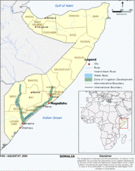 Map of Somalia. (Source: FAO)
 The climate in Somalia is mainly arid to semi-arid, with an average annual daytime temperature of 27°C. It is hot and dry in the interior and on the Gulf of Aden, but cooler on the Indian Ocean coast and inland on the river floodplains. The mean annual precipitation is 282 millimeters (mm), with 50 mm along the northern coast, 500 mm in the northern highlands, 150 mm in the interior plateau, and 350-500 mm in the southwest. Somalia has one of the highest inter-annual variations of rainfall of any mainland African state, and it is this variability that has the most pervasive influence on pastoral and agropastoral production systems. Rainfall distribution is bimodal. The rains seasons being the Gu (April to June), which has most rains and the Deyr (October to November). The dry seasons are the Jilal (December to March) and the Hagaa (July to September). Annual potential evapotranspiration varies between 1,500 mm on the south coast and 2,900 mm on the north coast. The country is regularly subjected to drought, occurring moderately every 3-4 years and severely every 7-9 years.
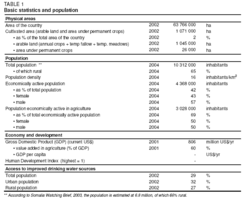 Table 1. Basic statistics and population. (Source: FAO)
 Population estimates for Somalia vary from 6.8 million, according to the Somalia Watching Brief (2003), to 10.3 million, according to the UN (Table 1). About 65 percent of the population are rural. Population density is 16 inhabitants/km2 and the annual population growth rate was 2.3 percent between 1990 and 2002. A majority of the population remains nomadic, either pastoralist or agropastoralist. Agriculture is the second most common occupation. Somalia’s agro-pastoralist and settled farmers live in villages or small settlements where water resources are reliable, while the nomadic pastoralists move seasonally with their livestock depending on the availability of pasture and water. In 2001, Somalia counted about 300,000 internally displaced persons and 264,000 refugees in neighboring countries. Up to 77 percent of the population are without access to safe water and 49 percent are without access to sanitation. The prevalence of HIV/AIDS is estimated to be less than 1 percent.
Economy, Agriculture, and Food Security
In 2001, the Gross Domestic Product (GDP) for Somalia was estimated at around US$806 million, whereas the Gross National Product (GNP) is higher due to remittances, totalling US$300-400 million, from Somalis living abroad. The expected share of contributions to the GDP by sector is 60 percent for agriculture, 10 percent for industry and 30 percent for services. About 69 percent of the economically active population were economically active in agriculture (2004). In 2002, 43 percent of the population were estimated to be on a per capita income of less than US$1/day. Constraints on development are scarce water resources, poverty, and food insecurity in the rural areas, general insecurity and civil conflicts. The situation is exacerbated by the uncontrolled urbanization of vulnerable people and the transfer of internally displaced people to the cities. Somalia has been food insecure for the past 20 years, a situation which has been aggravated by civil war and natural disasters. The country has one of the world’s highest figures for prevalence of undernourishment, 70 percent. In the early 1990s, 300,000 people died from hunger as a result of years of droughts. During the floods of 1997/1998, around 1,400 people died as a result of the flooding and another 1 million were indirectly affected, while more than 60,000 ha of crops and farmland were destroyed. In 1998 and 2000 Saudi Arabia imposed a ban on livestock imports due to the outbreak of rift valley fever. Somalia was hit hard by famine in 2002 and acute shortages of water and fodder caused losses of up to 40 percent of cattle and 10-15 percent of goats and sheep in Ethiopia and Somalia.
The local production of mainly sorghum and maize does not meet the food demands and it is estimated that another 200,000 tonnes of cereals are needed to meet the domestic food demands of 500,000 tonnes. Maize and sorghum production has been on average 60 percent below the pre-war average. Generally, the north has a higher food security due to better physical security and higher household income, compared to the south and central areas. It is estimated that one out of five harvests in Somalia is a partial failure and one in ten a complete write-off. Exports amounted to US$186 million in 1999 and the main commodities were live animals, meat, and skins mainly to Saudi Arabia. Imports amounted to US$314 million in 2000 and the main commodities were petroleum products, food stuffs, and construction materials. The Somalia Aid Coordinating Body (SACB) external aid amounts to US$115 million for humanitarian and development aid. The informal private sector boomed last year in money transfers and telecommunications, and construction and trade have become more important. Bananas were the most important export crop before the war and annual export exceeded 120,000 tonnes. Many of the banana farms were rehabilitated between 1993 and 1996, but the floods in 1997 destroyed 80 percent of the banana farms. Changes in the import regime, particularly to the EC and Italy, have led to a further collapse of the market. The few remaining commercial farms in southern Somalia have attempted to diversify into other crops, such as sesame, groundnuts, and rice.
The most important agricultural areas are in the south of Somalia and the agricultural production system can be divided in: (i) subsistence rainfed farming, often part of agro-pastoral production systems, with a typical farm size of 2-4 ha; (ii) small-scale irrigation and oasis farming; and iii) commercial farming, which is mainly large-scale and irrigated.
Water Resources
Water Resources
Water resources in Somalia are dominated by surface water. The two perennial [[river]s] in Somalia are the Juba and Shabelle rivers. The Juba-Shabelle basin, with a total area of 810,427 km2, covers about one-third of Ethiopia, one-third of Kenya, and one-third of Somalia. Over 90 percent of the flow originates in the Ethiopian highlands. The mean annual runoff at the border between Ethiopia and Somalia is 5.9 cubic kilometers (km3) for the Juba river at Luuq and 2.3 km3 for the Shabelle river at Belet Weyne. The downstream discharge at the Shabelle river is decreasing rapidly due to losses from seepage, evaporation, overbank spillage due to a low channel capacity, and water abstractions before the flow usually ends in the wetlands beyond Sablaale. Although the Shabelle river is technically a tributary of the Juba it is very rare that flow from the Shabelle ever reaches the Juba and often the Shabelle ceases to flow in the lower reaches during the early part of the year. Destructive floods have affected the Juba and Shabelle basin since the beginning of the century and especially in 1946, 1961, 1981, and 1997/1998. Usually the floods follow heavy rains in the upper basin in Ethiopia, with the Lower Juba floodplain being the worst affected area. As the Shabelle river is embanked at the lower part it is very difficult to predict the location of the floods. Sedimentation in the riverbed and siltation of the irrigation canals are also contributing to in-channel floods.
In the north, along the Gulf of Aden, there is a mountainous zone with rugged relief which is subject to torrential flows, causing considerable erosion. The land slopes down towards the south and the south-flowing watercourses dissipate in the Haud plateau. Groundwater potential is limited because of the limited potential for recharge.
Internally produced water resources are 6 km3/year, of which 5.7 km3 and 3.3 km3 are surface water and groundwater respectively, with an overlap between the two estimated at 3 km3. Total renewable water resources in Somalia are 14.2 km3/year. However, not all the resources can be captured due to floods. There are no dams on the Juba and Shabelle [[river]s] within Somalia, and pre-war flood-control measures (off-stream reservoirs, flood relief canals) have fallen into disrepair. There is an off-stream storage at Jowhar (0.2 km3), upstream of the greater part of the irrigated lands and downstream of the Jowhar sugar estate, which collapsed in the mid 1990s. A second off-stream storage reservoir in the Shabelle at Duduble, upstream of Jowhar, which would store 0.13-0.2 km3 , was proposed in the late 1980s, but was never built. At Baarhere on the Juba river a major water development project was proposed in the 1980s for hydropower, water control, and irrigation for about 175,000 ha of land.
Water Use
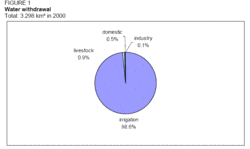 Figure 1. Water withdrawal. (Source: FAO)
 Total water withdrawal is estimated at 3.298 km3/year (2003), of which agriculture (irrigation and livestock) accounts for 99.5 percent (Table 2 and Figure 1). In the rural areas domestic water supply is derived from surface dams, boreholes, shallow wells, and springs, often distributed by donkey carts to households. During the dry season groundwater is the main supply for domestic and livestock use and is only supplemented by surface water when and where it is available.
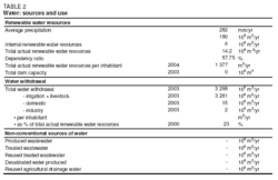 Table 2. Water: sources and use. (Source: FAO)
 Agricultural water abstractions are mainly limited to partially controlled irrigation schemes in the river basins. Of the abstractions for agriculture, livestock accounts for around 0.03 km3/year. Under the present conditions, surface water withdrawal amounts to around 96 percent and groundwater withdrawal to 4 percent of the total water withdrawal. In the dry season, as the water resources become scarce, competition between the resources is high and groundwater supplies are often severely stressed.
International Water Issues
The Shabelle river is partially regulated upstream in Ethiopia by the Melka Wakana 153 megawatts (MW) hydroelectric project, completed in 1988, as well as dams on two branches downstream which altogether control 40 percent of the catchment area and around 50 percent of the discharge. Further water development projects are ongoing in the Shabelle river on the Ethiopian side at Gode, but the capacity and implications for water management in Somalia are as yet unknown. For the shared water resources there are no recorded agreements between the countries.
Irrigation and Drainage Development
Evolution of Irrigation Development
Irrigation potential is 240,000 ha. The irrigation sector has undergone major changes since the outbreak of the civil war in 1991, many of the large scale irrigation systems having been destroyed. Of the remaining infrastructures many are not in use due to lack of maintenance and most of the formerly irrigated areas are now used for rainfed farming and grazing. There has been an expansion of rainfed farming, mainly in the areas of Middle Shabelle and Galgaduud.
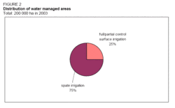 Figure 2. Distribution of water managed areas. (Source: FAO)
 Large-scale commercial irrigation was introduced during the colonial era (1880-1960) and played a major role in pre-war agriculture. Irrigated bananas and fruit trees (limes) were the major crops. Other crops, produced mainly by government-owned farms, were sugar cane, cotton, and rice. Most of the private and government-owned farms collapsed in 1990, but several private farms have recovered and diversified into cash crops, such as sesame, groundnuts, and rice. However, the technical level of production, mechanization, and efficiency of these farms remains low. Unsettled land issues are also constraints on future development.
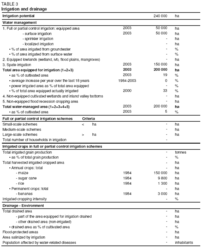 Table 3. Irrigation and drainage. (Source: FAO)
 The area equipped for irrigation was 200,000 ha in 1984, of which 50,000 ha full/partial control surface irrigation and 150,000 ha spate irrigation (Table 3 and Figure 2). These estimates are still valid today, but much of the infrastructure is not used. The area actually irrigated is only around 65,000 ha.
Irrigated agriculture is mainly practiced along the Juba and Shabelle rivers. In their upper sections both [[river]s] have deep riverbeds and pumps are needed for irrigation. In the lower sections the rivers are embanked, which allows for gravity-fed irrigation, especially along the Shabelle. Pumps are used by those who can afford it during periods of low discharge. There are three common types of small-scale irrigation found in the Juba and Shabelle basin:
- Small-scale pump-fed surface irrigation of cash crops. Individual families or small groups usually irrigate 0.5-5 ha close to the river;
- Small-scale gravity-fed surface irrigation of staple and cash crops, with clusters of small-scale farmers irrigating 5-10 ha. Maize is most common, followed by sesame, fruits, or vegetables;
- Spate and flood recession irrigation of staple crops. Spate irrigation is called Deschek irrigation and it also includes the areas along the riverbanks, which are often called riverbank farms (5-100 meters (m) from river). When the bi-annual floods begin to recede farmers plant maize in depressions and dry river branches, particular along the middle and lower reaches of the Juba. Flood recession farming is practiced from 500 m to up to 30 km distance from river. The system is quite risky as the floods can return before the crops are harvested. The areas are flooded through levee or embankment overtopping using water intakes through man-made openings along the river or by pumping, thus changing uncontrolled irrigation to controlled. No separate values are available for the part called spate irrigation or flood recession cropping.
In the dryer northern part of Somalia irrigation is practiced as small-scale surface irrigation and as spate irrigation. Small-scale surface irrigation, oasis farming, is practiced mainly in dry riverbeds or adjacent areas, using water pumped from shallow wells and in some cases by tapping the sub-surface river flow directing it through channels into the fields. These farms produce mainly fruits and vegetables for neighboring villages and urban centers and the irrigated area for these farms is usually less than 2 ha. Less common is spate irrigation which is practiced as floodwater harvesting within the [[stream]bed] or by floodwater diversion where the floods are diverted to adjacent fields for sorghum and maize, with an irrigated area usually of less than 10 ha.
Role of Irrigation in Agricultural Production, the Economy, and Society
Livestock and agriculture, both rainfed and irrigated, are the two major traditional socio-economic activities of the Somali people, where water is of vital importance. Water is scarce and the infrastructural developments with access to water for household and irrigated agriculture are very poor and often communities fight over the access to land and water. The production of staple crops is subsistence-oriented and dominated by smallholders. Fodder as a by-product often has a higher economic value then cereals, particularly in the north where livestock export is important. Irrigation efficiency is low because of the design of the system. Both men and women work on the farms. However, as regards access to land, women are not allowed to own land if they do not purchase it with their own money.
The main cash crops are bananas, lime, cotton, rice, and sugar cane, while the main food crops are sorghum, maize, sesame, rice, and beans. Rainfed and irrigation yields are low due to low seed quality and due to lack of farming skills and mechanized farm inputs. The average yield of sorghum is 200,500 kilograms per hectare (kg/ha). On average 300,000 tonnes of cereals were harvested per year during the period 1994-2000, compared to a pre-war production of 480,000 tonnes per year.
Status and Evolution of Drainage Systems
Many flood diversion control systems in the Juba and Shabelle river have collapsed and drainage is poor, leading to salinization and waterlogging. For example, in Jowhar (middle Shabelle) the major infrastructure that collapsed consisted of a flood control canal and the Jowhar off stream canal, operational from 1980 to 1990, and the Chinese flood relief canal, operational from 1983 to 1990.
Water Management, Policies, and Legislation Related to Water Use in Agriculture
Institutions
A platform for the coordination of international aid to Somalia is provided by the Somalia Aid Coordinating Body (SACB). The SACB was created in 1994 and partners include donor governments, United Nations (UN) agencies, and international and local non-governmental organizations (NGOs). The aim of the SACB is to share information and to develop strategies for aid in the sectors of health and nutrition, food security, and rural development, water/sanitation, and infrastructure, education and governance, and economic recovery. The UN development aid in Somalia is coordinated by the Office for Coordination of Humanitarian Affairs (OCHA). Food security at a household level has been monitored since 1995 by the Food Security Assessment Unit (FSAU) through regular assessments of vulnerability and food economy baseline studies.
The overall responsibility for agricultural development in northwest Somalia rests with the Ministry of Agriculture. A strategic plan for agricultural rehabilitation and development for 2001 and 2003 was developed with assistance from the International Rescue Committee (IRC). The goal of the strategic plan was to ensure household food security by ensuring an equitable allocation of resources, improving crop production, and capacity building within the Ministry of Agriculture. The ministry of Water and Mineral Resources is responsible for the management of freshwater resources and for water withdrawal. In northeast Somalia, the Ministry of Pastoral Development and Environment is responsible for natural resource management, including the use of forest and surface water and groundwater resources. It developed the strategic plan for sustainable natural resource management for 2002-2004.
Water Management
Canal committees and water use associations exist in some areas, but there is no clear pattern of water allocation rights and fees. On most of the small irrigation schemes with hand-dug canals canal committees exists and the schemes are better maintained compared to the large-scale irrigation schemes, which were maintained by former governments. Lack of sustainable irrigation management is also due to the fact that the land is irrigated by people who have no previous experience of irrigation.
Finances
Water, electricity, and transport are examples of private sectors that work well, but are only accessible for those who can afford to pay for them. There are no subsidies for agriculture and irrigation.
Policies and Legislation
In Somalia there are no uniform constitutional and legal rules governing social or economic behavior, except for a 1971 law governing the Water Development Agency. In Somaliland, a draft water Act and a Water Policy were prepared in 2004. In those areas where public administration has been established, advances have been made in restoring the former juridical system. In most of the rural communities, however, traditional Somali law (xeer) and the Islamic Sharia law continue to be upheld. The ownership of land and water is based on the Somali social organization where each clan is associated with a particular territory. The law says that water is public property but allows appropriation and usage is acquired by administrative permits.
Environment and Health
Environmental water-related problems concern shortage of water, use of contaminated water, overgrazing, salinization, waterlogging, recurrent drought, and severe floods. The coastal waters are degraded by the illegal cleaning of tanks and fishing, mostly by foreign fleets. The uncontrolled cutting of acacia and juniper forests for the export of charcoal and firewood is damaging the rangelands. From 1997 to 2003, it is estimated that charcoal production increased by 70 percent. Soil erosion in the form of sheet, rill, river bank, and gully erosion is extensive and has an impact on agricultural land. Soil erosion has also been accelerated due to land that has been left fallow. Substantial areas have been salinized and waterlogged by irrigation. Persistent crop pests are common and affect the quantity and quality of the harvest. Indicators of health have not shown any improvement for the population during the last few years. Farm labor is affected by malaria and tuberculosis, which are the two main human diseases. There is also a high incidence of malaria during the wet season when farm labor is needed. Tuberculosis is common among the pastoralist and agro-pastoralist communities.
Health facilities are concentrated in the urban centers, but water resources are very limited. In Hargeisa, the population has on average 7 liters of water per day and many people have much less than that. In Mogadishu the water supply is affected by saltwater intrusion from the sea because of extensive groundwater pumping. In some rural areas the construction and rehabilitation of water supplies has resulted in more people and livestock in the area, which has degraded the rangelands.
Perspectives for Agricultural Water Management
The long absence of a formal central government, conflict in the major agricultural production areas and the associated lack of investment are constraints on the rehabilitation/development of agricultural water management in Somalia. Due to continued civil war agriculture is now essentially subsistence agriculture, with limited opportunities for production for internal [[market]s] and virtually no capacity to produce for international markets. A recent study by the European Commission (EC) found no grounds for the rehabilitation of the once important banana industry on a competitive basis. On-farm investment is currently limited to essential needs.
As long as water management continues to be a localized affair, there remains little opportunity for developing effective strategies for flood management on the [[river]s]. This in turn undermines the cooperation needed with neighboring countries sharing the same water resources. Although emerging Somali authorities recognize the need and have identified the rehabilitation of the major flood control and irrigation infrastructure on the Juba and Shabelle rivers as a major priority, there is likely to be little progress until a strong central government emerges. Major investment opportunities, from donors or the private sector, therefore remain on hold.
Further Reading
- Agrosphere. 2002. An Agricultural Baseline of Jamama District - Lower Juba. Nairobi.
- European Commission (EC), Somalia Unit. 2001. Rural development and food security strategy for Somalia: towards sustainable livelihoods.
- Gomes, N. 2003. Water and land management in the riverine region of southern Somalia. Preliminary study, for FAO/EC, IFRA, Nairobi.
- Kammer D. 1989. A brief description of major drainage basins affecting Somalia. National Water Centre, Mogadishu. Field Document No.14. FAO/SOM/85/008. Rome.
- UNDP. 2001. Somalia Human Development Report 2001. UNDP Somalia Country Office, Nairobi, Kenya.
- World Bank. 1987. Agricultural Sector Survey: Main report and strategy. Report No. 6131-SO. Washington DC.
| Disclaimer: This article is taken wholly from, or contains information that was originally published by, the Food and Agriculture Organization. Topic editors and authors for the Encyclopedia of Earth may have edited its content or added new information. The use of information from the Food and Agriculture Organization should not be construed as support for or endorsement by that organization for any new information added by EoE personnel, or for any editing of the original content. |