Water profile of Lithuania
Contents
Geography and Population
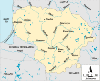 Map of Lithuania. (Source: FAO)
 Lithuania, with a total area of 65,200 square kilometers (km2), is one of the three Baltic states. It is bordered in the west by the Baltic Sea, in the north by Latvia, in the east and southeast by Belarus, in the southwest by Poland and the Russian Federation. It declared its independence from the Soviet Union in March 1990. For administrative purposes, Lithuania is divided into ten districts.
Lithuania is part of the east European plain. Within the country, lowland plains alternate with hilly uplands. From west to east, three lowland plains can be distinguished: the Pajuris, middle lowland and eastern lowland. Similarly, there are three uplands: the Zemaiciai (or Baltic), Aukstaiciai and eastern upland. The peak of the highest hill is at 293 meters (m) above sea level.
The cultivable area is estimated at about 3.9 million hectares (ha), which is 60% of the total area of the country. In 1994, the cultivated area was estimated at almost 2.6 million ha, of which 98% was covered by annual crops. The central and western parts of Lithuania are the best regions for crop production, especially the middle lowland. This region was almost entirely exploited before 1989-1991, in order to supply cities such as Moscow and Saint Petersburg with agricultural products.
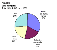 Figure 1. Land categories. (Source: FAO)
 In the Soviet era, agriculture was collectivized and organized in large-scale farms. After independence, agriculture was restructured and the land returned to its former owners, with extraordinary increases in productivity being witnessed after the collective era. The structure of Lithuanian agriculture is now characterized by three different types of farming. In 1995, private commercial farms occupied some 33% of the farmland. Collective commercial farms occupied some 20% of the farmland. Smallholdings, with an average size of 2 ha, occupied another 21%. The remaining 26% was under state ownership, rented out to various types of farms (Figure 1). The restructuring process has not yet been completed and legal titles for most of the land are still not settled.
The total population is 3.7 million (1996), of which 27% is rural. The average population density is 57 inhabitants/km2, but varies from 28 inhabitants/km2 in the Utena district to almost 95 inhabitants/km2 in the Vilnius district, where the capital Vilnius is located. The annual population growth was 0.2% in 1993. It decreased to -1% in 1994 and 1995. In 1996, about 18% of the economically active population was engaged in agriculture. In 1994, agriculture accounted for an estimated 7% of the gross domestic product (GDP).
Climate and Water Resources
Climate
Lithuania is a semi-humid country. The climate is transitional between maritime and continental. In the 12-15 kilometer-wide coastal zone it is maritime, and in the east of the country it is continental. The average annual precipitation is 748 millimeters (mm), ranging from less than 550 mm in the north to a maximum of more than 846 mm in the Zemaiciai hills. Over two-thirds of the precipitation occurs during the warm period, from April to October. The main issue in relation to agriculture is thus the removal of excess water to enable cropping.
River Basins and Water Resources
Rivers and lakes have long been used as waterways, although, with the exception of the Nemunas River in the south of the country, they are not very suitable for navigation. Within the country, there are 722 rivers over 10 kilometers (km) long and 21 of them are more than 100 km long. Most of the rivers flow across the middle lowland and the western part of the Zemaiciai upland.
Six major river basins can be distinguished in Lithuania (Figure 2):
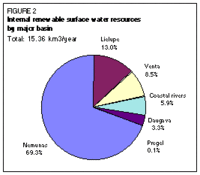 Figure 2. Internal renewable surface water resources by major basin. (Source: FAO)
 - The Nemunas basin. It is by far the largest river basin in the country, covering 65.9% of the country. The Nemunas River rises in Belarus and enters Lithuania in the south. It flows first north and then turns to the west. It becomes the border between Lithuania and the Russian Federation before flowing into the Baltic Sea. Its major tributaries are the Neris River, rising in Belarus, and the Sesupe River, rising in Poland.
- The Lielupe basin. It covers 16.4% of the country. Several rivers, such as the Svete, Musa, and Memele, rise in the north of Lithuania. They flow into Latvia and become the Lielupe River after their confluence.
- The Venta basin. It covers 9.1% of the country. The Venta River rises in the northwest of Lithuania and flows into Latvia.
- The group of coastal basins. They cover 4.4% of the country.
- The Daugava River basin. It covers 4.1% of the country in the northeast. The Daugava River itself does not flow in Lithuania. Some tributaries, rising in Lithuania, flow northeast into Latvia, where they flow into the Daugava River.
- The Pregel basin. It covers less than 0.1% of the country in the southwest. It drains west into the Russian Federation.
The total IRSWR are estimated at 15.36 cubic kilometers pear year (km3/year); incoming surface water resources at 9.34 km3/year. The outflow into the Russian Federation is estimated at 0.85 km3/year; the outflow into Latvia at 4.01 km3/year.
Renewable Surface Water Resources (RSWR) by Major River Basin
|
| |||||||
| Name of river basin | Area within Lithuania | IRSWR | Inflow | Total RSWR | Outflow | ||
| km2 | % of total | km3/year | km3/year | from | km3/year | to | |
| Nemunas | 42,970 | 65.9 | 10.65 | 9.34 | Belarus (9.30);Poland (0.04) | 19.99 | Russian Fed.+ Sea |
| Lielupe | 10,690 | 16.4 | 2.00 | - | 2.00 | Latvia | |
| Venta | 5,930 | 9.1 | 1.30 | - | 1.30 | Latvia | |
| Coast | 2,870 | 4.4 | 0.90 | - | 0.90 | Latvia + Sea | |
| Daugava | 2,670 | 4.1 | 0.50 | - | 0.50 | Latvia | |
| Pregel | 70 | 0.1 | 0.01 | - | 0.01 | Russian Fed. | |
| Total | 65,200 | 100.0 | 15.36 | 9.34 | 24.70 | ||
Groundwater Resources
The internal renewable groundwater resources are estimated at 1.2 km3/year. It is considered that most of the flow is drained out by the river system and does not contribute to the total renewable water resource (RWR). However, that part of the groundwater which is withdrawn through wells can be added to the surface flow to make up the total internal renewable water resource (IRWR). The overlap has been estimated at 1 km3/year.
International Agreements
No international agreements or treaties on the sharing of water of international rivers exist between Lithuania and its neighbors. An agreement has been signed with Belarus on the exchange of information in the event of accidental pollution in the transboundary rivers. An agreement has been signed with Poland on the monitoring and protection of the transboundary Sesupe River and Lake Galadusis. An agreement with the Russian Federation on the protection and monitoring of the Nemunas River and the Curonian Lagoon might be signed in the future.
Lake and Dams
There are over 3,000 natural lakes in Lithuania, 25 of them with areas of more than 10 km2. They cover 1.5% of the total area of the country. Most lakes are concentrated in the Aukstaiciai uplands in the east of the country.
One large dam, the Kaunas dam, has been built on the Nemunas River for hydropower generation. Its total capacity is 0.46 km3 and its useful capacity is 0.22 km3. About 376 dams have been built for water storage for irrigation and flood control. Their total capacity is 1.36 km3 and their useful capacity is 0.23 km3. The reservoirs could also be useful for fishery and recreation. At present, the possible use of these dams for hydropower generation, by constructing small power stations, is under discussion. A nuclear power station has been built in Ignalina, in the east of the country.
Water Use and Wastewater
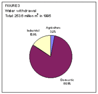 Figure 3. Water withdrawal. (Source: FAO)
 In 1995, the total water withdrawal for agricultural, domestic, and industrial purposes was 253.6 million cubic meters (m3), of which only 3.2% was for agricultural purposes (Figure 3). Livestock watering in rural settlements with centralized water supply is included in domestic water withdrawal. In addition, the nuclear power station used 4,099.2 million m3 of water for cooling; while 115.7 million m3 was considered necessary for fisheries and 1 million m3 for other non-consumptive uses.
The total quantity of produced wastewater in 1995 was 303.8 million m3, compared with 446.1 million m3 in 1990. This fall was mainly the result of reduced industrial production. Of this quantity, 77.9 million m3, or 26% (22% in 1990), was treated to reach the quality standards, 171.8 million m3, or 56%, was inadequately treated, and 54.1 million m3, or 18%, was not treated at all. In 1995, 4.8 million m3 of wastewater, partly treated in accumulating reservoirs, was reused for irrigation compared with 44.3 million m3 in 1990 (Figure 4). The remaining wastewater, both treated and untreated, was not re-used directly but discharged to the rivers.
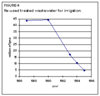 Figure 4. Reused treated wastewater for irrigation. (Source: FAO)
 In recent years, many farmers have no longer been able to afford fertilizers and pesticides. This has led to a significant decrease in their use and their leaching from the soil surface, resulting in a reduction in groundwater pollution.
In 1990, the total groundwater abstraction from some 12,000 tube-wells was 497.2 million m3. In 1995, it fell to 205.2 million m3 due to reduced industrial consumption and a decrease in domestic water withdrawal. As a result of the increased price of water for domestic purposes, many water consumers have installed water meters and started saving water. This downward trend is expected to be reversed in the near future, when an expected industrial recovery and a rise in living standards should lead to an increase in industrial and domestic water withdrawal.
Irrigation and Drainage Development
Drainage Development
In ancient times, Lithuanians removed excess moisture from fields by furrowing them, using a special way of plowing, or by making ditches. The first subsurface drainage systems are said to have been installed in 1855. Drainage works increased significantly at the beginning of the twentieth century, starting with the beginning of cultivation in the Nemunas River delta. In 1918, about 5,900 ha were known to be drained. In 1939, 14,800 ha of land were intensively drained, including 11,800 ha by subsurface drainage. In addition, 457,700 ha of land were drained extensively. Around 1 million ha of wetland had been drained by 1970 and 2 million ha by 1978. In 1995, the total drained area was estimated at about 3 million ha, of which 2.6 million ha, or 86%, were equipped with subsurface drainage systems (Figure 5). The total length of subsurface drainage lines is almost 1.6 million km. It is calculated that drainage systems have been installed on 90% of the area needing drainage, which is estimated at almost 3.4 million ha.
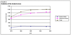 Figure 5. Evolution of the drained areas. (Source: FAO)
 The present cost of drainage installation is $US 1,700-2,000/ha. The additional grain crop harvest on drained lands is about 0.8-0.9 tons per hectare (t/ha), or 25-30%.
Drainage is usually carried out in conjunction with specific cultural practices: removing shrubs and stumps, gathering stones, plowing drained swamps and fallow lands. However, sometimes too many shrubs are removed, resulting in an increase in soil erosion. For this reason, serious attention is now being paid to environmental protection. The construction of new drainage systems has been suspended, and efforts are being made to maintain earlier installed drainage systems in a proper condition.
Irrigation Development
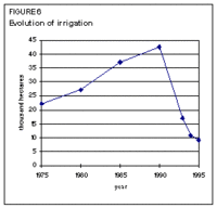 Figure 6. Evolution of irrigation. (Source: FAO)
 In the Nemunas River delta, about 40,000 ha of meadows in polders are protected by dams against flooding. About 100 pumping stations have been installed to remove excess water in periods of flood. However, initially this led to moisture deficit in dry periods. This problem was solved by the installation of sluices in the polders, enabling both the water level in the ditches to be regulated and irrigation in the driest periods. In 1976, 2,200 such systems, called sluice systems, were exploited. However, these systems were not used for long as sprinkler irrigation soon proved to be a more effective system of irrigation under Lithuanian conditions.
Since 1965, considerable research on sprinkler irrigation has been carried out in the country. The first sprinkler irrigation systems were installed in 1965 in the Kaunas and Këdainiai districts in the center of the country, where for some time domestic wastewater was used for irrigation. However, after an outbreak of cholera in the region in about 1970, the use of domestic wastewater for irrigation was forbidden.
In the period 1973-1985, 33 industrial pig complexes were built in the country. Irrigation systems were installed on 6,600 ha close to these complexes, using the dung as fertilizer.
The construction of irrigation systems is rather expensive, on average $US 7,500/ha, because of the need for reservoir construction. The average cost of operation and maintenance (O&M) is estimated at $US 250/ha per year. Nevertheless, irrigation systems have increased rapidly. By the end of 1970, irrigation covered 5,100 ha; in 1975 and in 1990 it was 22,300 and 42,700 ha respectively.
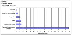 Figure 7. Irrigated crops. (Source: FAO)
 During the Soviet period, large irrigation systems were installed (100-200 ha) on kolkhoz (collective farms) and sovkhoz (state farms). After the end of collective farming, private owners started working on small plots (8-20 ha) and many of the large irrigation systems were abandoned. This is the reason for the decrease in irrigation in recent years. While 42,700 ha were equipped for irrigation in 1990, only 9,247 ha were left equipped for irrigation in 1995 (Figure 6). The rest of the system has largely been abandoned, as farmers have not been interested in using large, costly irrigation schemes.
Of the total actually irrigated area of 38,400 ha in 1990, 29,700 ha (77%) consisted of meadows and pastures. The remaining part was covered by fodder crops (beets), barley (spring crop), vegetables and wheat. Some 200 ha of gardens were irrigated (Figure 7). In 1994, the main rainfed crops were cereals (46%); fodder crops, including grasses (46%); and potatoes (5%).
Institutional Environment
The main institutions involved in water resources management are:
- The Ministry of Agriculture and Forestry. It is responsible for land reclamation and irrigation. The Land Reclamation Division within the Ministry is responsible for design, equipment, maintenance, land reclamation planning, and research.
- The Water Division within the Ministry of Environmental Protection. It is responsible for monitoring design, construction, equipment, maintenance, water planning, water research, sewerage, and sanitation.
- The Association of Land Reclamation Enterprises. This is an independent association of most of the land reclamation companies which has indirect links with the Ministry of Agriculture and Forestry. It is the principal public advisory body to the government on all issues related to the activities of land reclamation enterprises.
- The Ministry of Government Reforms and Local Administrations, the Ministry of Building and Urban Development and the local municipalities. They regulate issues on water supply, sewerage, and sanitation.
- The Association of Land and Water Management Engineers. This is a non-governmental organization for water management engineers. It is the principal public advisory body to the government on all matters related to land and water management.
The following laws relating to land and water are in force or under preparation:
- Land Reform Law of 1991
- Land Reclamation Law of 1994
- Water law (under preparation), containing sections on: general regulations; water use; water protection and prevention of harmful influences; state registration and planning of use of water sources; responsibility for water law violations.
Trends in Water Resources Management
Because of the prevailing economic situation, the state no longer bears the cost of constructing new drainage and irrigation systems, and can only partly cover the maintenance costs of the existing drainage systems. The new farms, which have replaced the kolkhoz, are also in a challenging situation. This means there is a risk of the progressive degradation of drainage systems. The future of the remaining irrigation systems is also unclear and, moreover, the cost of irrigation has increased due to the rising energy prices. Furthermore, the advisory service that organized the irrigation no longer exists. The state has referred the question of irrigation to the private initiative of farmers and agricultural companies. The Ministry of Agriculture and Forestry limits its activities to the collection of basic data about irrigation systems.
In the future, small-scale irrigation will probably take place more spontaneously under market forces, without government promotion. At present, some farmers are already showing initiative by buying foreign irrigation equipment. Irrigation water charges do not exist, but farmers must obtain an authorization from the Ministry of Environmental Protection to ensure that no damage to the environment will result.
Several wastewater treatment plants have been, or are being, built or reconstructed. In 1996, biological wastewater treatment plants were due to start operating in the city of Vilnius. The primary wastewater treatment plant in Kaunas is almost complete and it should become operational in 1997. The Klaipeda wastewater treatment plant is under reconstruction.
At present, the worst ecological situation exists in the Kulpe River in the north (Lielupe basin), to which wastewater from Siauliai city is discharged, and in the Nevezis River below Panevezys (Nemunas basin). The minimal summer discharges of these rivers are very low and therefore the wastewater has to be carefully treated. Part of the Sventoji river flow in the northeast of the Nemunas basin (from 1 to 4 m3/s) is used to maintain good sanitary conditions in the Nevezis River. For this purpose, a pumping station has been installed near Kavarskas in the Anyksciai district. The Siauliai wastewater treatment plant needs to be reconstructed and water cleaning efficiency needs to be improved. However, in view of the current economic situation, it is unlikely that these activities will be undertaken in the near future.
Further Reading
- Central Board of Statistics of Lithuanian SSR. 1981 and 1986. National economy of Lithuanian SSR in 1980 and 1985 (Lietuvos TSR liaudies ukis 1980 metai. Lietuvos TSR liausies ukis 1985 metais). Mintis, Vilnius.
- Department of Environmental Protection of the Lithuanian Republic. 1991. Environmental conditions, tendencies of changes, control of environmental protection (Aplinkos bukle, kitimo tendencijos, aplinkos apsaugos valdymas). Vilnius.
- Department of Land Reclamation. 1994 and 1995. Reclaimed land and land reclamation. Normative documents of Land Reclamation, Part I (1994.01.01) and Part II (1995.01.01) (Melioruotosios zemes ir melioraciniai irenginiai. Melioracijos normatyviniai dokumentai. I dalis (1994.01.01) + II dalis (1995.01.01)). Ministry of Agriculture of the Lithuanian Republic, Vilnius.
- Department of Statistics to the Government of the Republic of Lithuania. 1995. Statistical yearbook 1994-95 (Lietuvos statistikos metrastis 1994-95). Methodical Publishing Centre, Vilnius.
- Department of Statistics to the Government of the Republic of Lithuania. 1996. Lithuania in figures 1996 (Lietuva skaiciais 1996). Methodical Publishing Centre, Vilnius.
- European Commission, Directorate General for Agriculture. 1995. Agricultural situation and prospects in the Central and Eastern European countries. Country: Lithuania. Working document. EC.
- Garunkstis, A. 1988. Lithuanian waters (Lietuvos vandenys). Mokslas, Vilnius.
- Ministry of Environmental Protection. 1995 and 1996. Work reports for 1994 and 1995 (Aplinkos apsaugos ministerijos 1994+1995 m.). Darbo ataskaita, Vilnius.
- Ministry of Land Reclamation and Water Management of the Lithuanian SSR. 1985. The main indexes of protection and exploitation of water resources of the Lithuanian SSR for 1984. Vilnius.
- State Service of Land Exploitation and Geodesy at the Ministry of Agriculture. State Land Register Enterprise. 1996. The lands of the Republic of Lithuania on 1 January 1996 (Lietuvos Respublikos zemes fondas 1996 m. Sausio 1 d.). Vilnius.
- Water Profile of Lithuania, Food and Agriculture Organization.
- World Factbook: Lithuania, Central Intelligence Agency.
| Disclaimer: This article contains information that was originally published by, the Food and Agriculture Organization. Topic editors and authors for the Encyclopedia of Earth have edited its content and added new information. The use of information from the Food and Agriculture Organization should not be construed as support for or endorsement by that organization for any new information added by EoE personnel, or for any editing of the original content. |
