Water profile of Georgia
Contents
Geography and Population
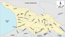
Georgia, with a total area of 69,700 square kilometers (km2), is located in the Caucasus region in the southeast of Europe. It is bordered by the Russian Federation in the north, Azerbaijan in the southeast, Armenia] and Turkey in the south, and the Black Sea in the west. For administrative purposes, the country is divided into 11 regions (comprising some 67 districts) plus the capital city Tbilisi. It declared its independence from the Soviet Union in April 1991.
 Map of Georgia. (Source: FAO-Forestry)
 The country can be divided into three physiographic regions: mountains covering about 54% of the total area, highlands about 33%, and valleys some 13%. The northern boundary consists of the Caucasus mountains, whose highest peak stands at some 5,000 meters (m) above sea level. About 70% of the territory lies below 1,700 m above sea level. Cropping is possible throughout the country up to 2,000 m. At higher elevations, only pastures are reported.
Since the end of the Soviet period, a process of land privatization has been undertaken. Of the total agricultural land of 3 million hectares (ha), some 0.7 million ha are now owned and cultivated by private farmers; 0.3 million ha have been leased to farmers for short-term (3-5 years), medium-term (25 years) or long-term (49 years) periods; while 2 million ha are still owned by the state (Figure 1). Except for some seed-breeding farms, most of the state-owned land, which is no longer managed by sovkhoz (state farms) or kolkhoz (collective farms), is not cultivated.
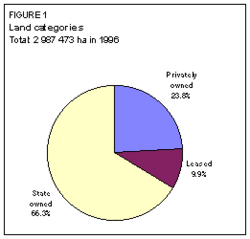 Figure 1: Land categories. (Source: FAO-Forestry)
 The total cultivable area, which according to Georgian statistics is equal to the agricultural area, was estimated in 1996 at some 3 million ha, or 43% of the territory. About 2.2 million ha are forest, which, under the Forest Code of 1978, cannot be transformed into agricultural cropped areas. The cultivated land is estimated at 1.06 million ha, of which 29% of permanent crops and 71% of annual crops.
The total population is estimated at 5.4 million (1996), of which 41% is rural. The average population density is 78 inhabitants/km2, but varies from 25 inhabitants/km2 in the mountainous areas to 250 inhabitants/km2 in the valleys. Before independence, the annual population growth was about 1% per year, but since 1991, the growth has been negative. In 1995, the population was estimated to be 1% less than in 1991. Agriculture employs some 25% of the economically active population. Due to the shrinking of the industrial sector since 1990, the contribution of agriculture to Gross Domestic Product (GDP) reached 38% in 1995, a share much higher than in the 1980s.
Climate and Water Resources
Climate
Georgia, with an average rainfall of 1,065 millimeters (mm)/year, can be divided into two climatic regions:
- West Georgia, where the climate is subtropical humid. The average precipitation is estimated to vary between 1,100 and 1,700 mm/year. Drainage of excess water is one of the main problems for agriculture in this part of the country. Average temperatures vary between 5°C in January and 22°C in July.
- East Georgia, where the climate is subtropical dry. The average precipitation varies between 500 and 1,100 mm/year. About 80% of the rainfall occurs from March to October, while the longest dry period is about 50-60 days. Drought years are common. Hail occurs in spring and autumn. There is a need for irrigation in the areas where precipitation is less than 800 mm/year. Average temperatures vary between -1°C in January and 22°C in July.
River Basins and Water Resources
The country can be divided into two main river basin groups:
- The Black Sea basin, in the west of the country. The RSWR generated in this basin are estimated at 42.5 cubic kilometers per year (km3/year). The main rivers are, from north to south, the Inguri, Rioni, and Chorokhi. The main stream of the Chorokhi rises in Turkey (the Corub River), and the inflow from Turkey is estimated at 6.3 km3/year.
- The Caspian Sea basin, in the east of the country. The RSWR generated in this basin are estimated at 14.4 km3/year. The main rivers are, from north to south: the Terek and Andiyskoye rivers, which rise in the north of the country and flow northeast to the Russian Federation before entering the Caspian Sea; the Alazani, Iori, and Kura rivers, which rise in Georgia and flow into Azerbaijan in Lake Adzhinour, and then flow southeast in Azerbaijan before entering the Caspian Sea. Two tributaries of the Kura River rise in Turkey: the Mktvari, with an inflow from Turkey estimated at 0.91 km3/year; and the Potskhovi, with an inflow from Turkey estimated at 0.25 km3/year. The inflow of the Debet River, a southern tributary of the Kura River, is estimated at 0.89 km3/year from Armenia.
The renewable groundwater resources are estimated at 17.23 km3/year, of which, however, 16 km3/year are considered to be drained by the surface water network (overlap). In 1990, the total water abstraction was estimated at 3 km3/year from some 1,700 tube-wells. A further 7 km3/year could be abstracted in the future according to a recent assessment. Groundwater use was not greatly developed during the Soviet period, due to the emphasis on large-scale state-run surface irrigation schemes.
The IRWR are estimated at 58.13 km3/year and the ARWR at 63.33 km3/year.
International Agreements and Actual Water Resources
In 1925, an agreement with Turkey was reached on the use of water of the Chorokhi River, allocating half of the average surface water flow to each country. This agreement dealt only with water flow and did not consider the sediment flow estimated at 5 million cubic meters per year (m3/year). About 46% of these sediments form the sand beach and are an important resource, as tourism is of prime importance to Georgia's earnings. Turkey is presently planning to construct a cascade of 11 dams on the Chorokhi River, which will affect the sediment flow and thus the beaches on the Georgian shore. Georgia is pressing for a reconsideration of the agreement, which should not only deal with the allocation of water but also address the issue of sediment flow.
Armenia and Georgia are now working on agreements about the use of the Lake Khanchali and Debet River waters.
Lakes and Dams
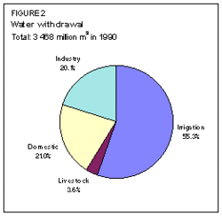 Figure 2: Water withdrawal. (Source: FAO-Forestry)
 There are about 43 dams in Georgia, and their total reservoir capacity is estimated at about 3.2 km3. The largest dam, for hydropower, is the Inguri dam, with a reservoir capacity of 1.092 km3. In 1995, hydropower supplied 89% of electricity. For irrigation purposes, some 31 dams have been built, with a total reservoir capacity of 1 km3, of which 782 million m3 is active. The three largest irrigation reservoirs are all on the Iori River: the Sioni reservoir upstream (325 million m3), the Tbilisi reservoir (308 million m3), and the Dalimta reservoir downstream (180 million m3).
Water Withdrawal and Wastewater
The total water withdrawal was estimated at 3.5 km3/year in 1990 (Figure 2), less than in 1985 (4.6 km3). The main reason for this decrease has been the industrial decline since the end of the Soviet Union. This decline resulted in a 50% reduction in industrial water withdrawal between 1985 and 1990.
In 1985, the total produced wastewater was estimated at 614 million m3, of which 279 million m3 (45%) was treated. There is no tradition of treated wastewater re-use in Georgia.
Irrigation and Drainage Development
Irrigation Development
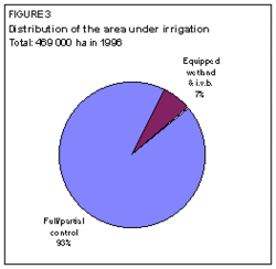 Figure 3: Distribution of the area under irrigation. (Source: FAO-Forestry)
 The irrigation potential in Georgia is estimated at 725,000 ha.
There is a tradition of land improvement through irrigation and drainage in Georgia. At the beginning of the twentieth century, the total irrigated area in Georgia was about 112,000 ha.
In 1996, irrigation covered 469,000 ha, of which 31,500 ha of equipped wetland and inland valley bottoms and 437,500 ha of full or partial control irrigated areas (Figure 3). River diversion is the main source of water for irrigation (Figure 4). Groundwater is not used for irrigation in Georgia.
Major investments were made in the irrigation sector during the Soviet period. This resulted in a total area of about 500,000 ha equipped for irrigation at the beginning of the 1980s.
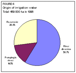 Figure 4: Origin of irrigation water
 The main irrigation technique developed on full or partial control irrigation equipped areas is surface irrigation (Figure 5). Micro-irrigation was practiced on an experimental basis on 200 hectares (ha) in east Georgia at the beginning of the 1990s. However, all micro-irrigated areas were destroyed between 1991 and 1994. Moreover, the high costs of micro-irrigation development have so far limited the scope for future expansion.
Most of the schemes are large-scale schemes (Figure 6). The largest schemes are: the upper Alazani (41,100 ha), the lower Alazani (29,200 ha), the upper Samgori (28,100 ha), and the lower Samgori (29,200 ha).
The part of the equipped area which is actually irrigated is estimated as being limited to 273,769 ha, which is only 63% of the total area, mainly because of security problems for farmers, severe economic stringency and the prevailing political situation.
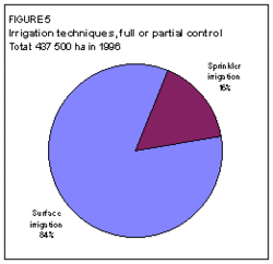 Figure 5: Irrigation techniques, full or partial control. (Source: FAO-Forestry)
 There is no private irrigation in Georgia. All irrigation schemes are managed by the state through its Department of Land Improvement and Water Economy. Though irrigation remains the responsibility of the state, the land irrigated might be owned either by private farmers or by the state but leased to farmers, cooperatives or agro-firms.
At the beginning of 1997, irrigation water charges were introduced in Georgia, on a basis of $US 3 per 1,000 m3. This figure is the same for all schemes in Georgia. It will probably increase in the future since it does not enable operation and maintenance (O&M) costs to be fully recovered. The water charges cover about 12% of the total O&M costs, the government budget covers 15% of the total, while the remaining 73% are not covered, resulting in the degradation of the irrigation systems. In 1996, over 300,000 ha were estimated to be in need of rehabilitation. The current policy is for the government to pay for the O&M of the dams and headworks which have been constructed, while the O&M costs of the distribution and on-farm network should be paid by irrigation users through a higher water charge.
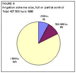 Figure 6: Irrigation scheme size, full or partial control. (Source: FAO-Forestry)
 The average cost of irrigation development (1996) varies between $US 3,500 and 4,500/ha for surface irrigation, and between $US 6,500 and 7,200/ha for sprinkler irrigation. Average O&M costs vary between $US 55 and 70/ha per year respectively.
In 1986, the major crops cultivated under full or partial control irrigation were fruit trees and grapes, pasture and fodder crops, vegetables, potatoes, wheat, maize, and sunflower (Figure 7). Irrigated crop yields compared relatively favorably with rainfed crop yields, although the average difference is very low due to the good climatic conditions in the areas where rainfed agriculture is practiced. In 1986, in the full or partial control irrigation schemes, the average irrigated crop yields were 3.0 tons per hectare (t/ha) for winter wheat, 2.9 t/ha for maize, 4.8 t/ha for grapes, 5.0 t/ha for fruits and 12 t/ha for potatoes.
Drainage Development
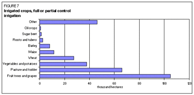 Figure 7: Irrigated crops, full or partial control. (Source: FAO-Forestry)
 In 1996, the total drained area was estimated at 164,740 ha, consisting mainly of surface drainage (Figure 8).
Drainage has been developed mainly in the high rainfall region of western Georgia (Kolkhety lowland), on 132,940 ha out of a total of 164,740 ha for the whole country. The total area of Kolkhety lowland, where drainage infrastructure could be developed in the future, is about 800,000 ha.
About 31,800 ha of full or partial control irrigation equipped areas are also equipped with a network of surface and subsurface drains (Figure 9). About 31,100 ha of the equipped wetland and inland valley bottoms are also power drained. They are located in the coastal regions of west Georgia, in polder systems where electric pumps drain seawater and excess floodwater.
Institutional Environment
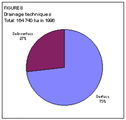 Figure 8: Drainage techniques. (Source: FAO-Forestry)
 The main institutions involved in water resources management are:
- The Ministry of Agriculture and Food, with:
- the Department of Land Improvement and Water Economy, responsible for planning, monitoring, and promoting irrigated agriculture. This department defines the water requirements for irrigation and supervises the management of the irrigation schemes.
- the Hydraulic Design Institute (Saktskalproject), responsible for irrigation, drainage, flood control, land reclamation, hydroelectric and water supply schemes design.
- the Georgian Scientific Research Institute of Water Management and Engineering Ecology, responsible for research into all issues related to water.
- The Ministry of Environment and Natural Resources Planning, with:
- the Water Resources Pollution Department, which is responsible for the control and regulation of water pollution. In the future it will be the principal advisory body to the government on all matters related to the utilization of water resources.
During the Soviet period, many administrative units were involved in the management of the same irrigation scheme. With the institutional changes which have occurred in Georgia, every scheme is now directly managed by one of the 48 administrative units of the Department of Land Improvement and Water Economy.
A water law is being prepared and should be submitted to parliament in 1997.
Trends in Water Resources Management
The irrigation and drainage schemes are in a poor condition. It is estimated that about 300,000 ha, or 68% of the whole irrigation system, need rehabilitation. However, the cost of rehabilitation is very high, and in the cases of several power irrigated schemes, rehabilitation might not be economically justified.
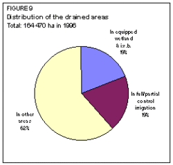 Figure 9: Distribution of the drained areas. (Source: FAO-Forestry)
 An important constraint is the design of the surface irrigation schemes. Most of the medium- or large-scale schemes were designed during the Soviet period, when the plots were very large. Because of the privatization process in Georgia, most farms now consist of small plots, which require a different water model. Reorganization and simplification of water distribution system in medium- and large-scale schemes is thus a priority.
Small-scale irrigation is developing without any subsidies from the government. Groundwater irrigation is likely to increase in the future for small-scale irrigation schemes, but only in western Georgia where the shallow aquifers are located.
Future irrigation development is expected to be on a very limited scale, particularly for large-scale and medium-scale schemes, mainly because of the high opportunity cost and the shortage of funds. Flow regulation through dams would be needed for these schemes, but the competition between hydropower and irrigation, which do not need water at the same periods, prevents the construction of multipurpose dams.
Although no WUAs have been established so far, farmers will be encouraged to form such associations in the near future, within the framework of the new water law currently under preparation. This law should provide a legal framework for the establishment of water charges in irrigation.
Drainage works might be carried out in the future, particularly in the Kolkhety lowland, with attention to ecological and environmental analysis. The eradication of malaria in this area would be one of the goals of these drainage works. However, opponents of this project propose the halting of land reclamation in the Kolkhety lowland and the creation of a national park.
Emphasis should be placed on drainage maintenance, since some 60% of the salt-affected areas have been equipped with drainage infrastructure, but are no longer being maintained. Salinization is therefore likely to occur in these areas.
Further Reading
- Water profile of Georgia, Food and Agriculture Organization.
- World Factbook: Georgia, Central Intelligence Agency.
- Department of Land Improvement and Water Economy. 1996. Some suggestions on the rehabilitation of land improvement of Georgia. Ministry of Agriculture and Food of Georgia. Tbilisi, 11 p.
- European Union: Technical Assistance for the Commonwealth of Independent States [TACIS]. 1996. Irrigation and drainage evaluation. Prepared by Anthony Zagni for Project No.FDREG9501A, Regional Agricultural Reform Programme, 1, Caucasus Region, Georgia. 60 p.
- World Bank. 1996. Georgia: reform in the food and agriculture sector: a World Bank country study. Washington, D.C., 170 p.
| Disclaimer: This article is taken wholly from, or contains information that was originally published by, the Food and Agriculture Organization. Topic editors and authors for the Encyclopedia of Earth may have edited its content or added new information. The use of information from the Food and Agriculture Organization should not be construed as support for or endorsement by that organization for any new information added by EoE personnel, or for any editing of the original content. |