Water profile of Gambia
Contents
- 1 Geography, Climate, and Population
- 2 Economy, Agriculture, and Food Security
- 3 Water Resources and Use
- 4 Irrigation and Drainage Development
- 5 Water Management, Policies, and Legislation Related to Water Use in Agriculture
- 6 Environment and Health
- 7 Perspectives for Agricultural Water Management
- 8 Further Reading
Geography, Climate, and Population
The Gambia is situated in the Sahelian zone on the West Coast of Africa. It is the smallest country on the African continent with a total area of 11,300 square kilometers (km2), of which about 20% is considered as wetland. The River Gambia runs from east to west, dividing the country in two strips of land 25 to 50 kilometers (km) wide and about 300 km long.
In the Gambian landscape two major geomorphological units may be distinguished, the uplands and the lowlands:
- On the upland plateaus, weathered (Soil erosion and deposition) tropical soils are found. These soils have low intrinsic fertility and low water retention capacity, but their drainage conditions are good. The plateau is intersected by watercourses flowing downwards on the lowlands. These streams have formed narrow fluvio-colluvial valleys (Wulumbangos).
- The lowlands include the floodplain of the River Gambia in the Upper Valley (UV), and tidal plains (Bantafaros) in the Central Valley (CV) and Lower Valley (LV). The soils of the lowlands are flat, fine textured, and poorly drained. In the LV potentially acid sulphate soils occur, which can become acid sulphate soils unless waterlogging is prevented by drainage.
 Map of Gambia. (Source: FAO-Forestry)
 The vegetation of the Gambia is of the savanna type with shrub and grass understories. Mangroves are found in the western half of the country in the floodplains of the River Gambia. The cultivable land area is estimated at about 430,000 hectares (ha), which is 38% of the total area. In 2002, arable land was 250,000 ha, while 5,000 ha were under permanent crops (Table 1).
The Gambia lies in the Sahelian agro-climatic zone and its climate is characterized by two different seasons: a rainy season from June/July to October and a long dry period between November and May. The dry season is characterized by a hot, dry wind blowing southwards from the Sahara desert, which can bring sandstorms. There has been a steady decline in rainfall from 1875 onwards which is causing increased salinity in the lowlands and increased aridity in the uplands. Average annual rainfall is 836 millimeters (mm), with a spatial variation from over 1,000 mm in the south to less than 800 mm in the north. In the areas where there is less rainfall, it is generally more reliable. As much of the wet season rainfall falls in short heavy storms, water conservation is essential to ensure crop security. However, there is a risk of washout due to the severity of the rainfall. The average daily temperature is 30°C in the dry season and 27°C in the wet season.
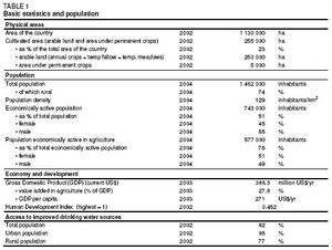 Table 1: Basic statistics and population. (Source: FAO-Forestry)
 Total population was almost 1.5 million in 2004, of which 74% was rural. Annual population growth rate was 2.7%, and population density reached 129 inhabitants/km2. In 2002, 82% of the population had access to improved drinking water sources; this coverage was 95% and 77% for urban and rural areas respectively. Sanitation coverage was 53% for the whole country in 2002, corresponding to 72% in urban and 46% in rural areas.
The Gambia is among the poorest countries in the World. It was ranked 155th out of 177 in the UNDP Human Development Index of 2002. Poverty in the Gambia has increased drastically since the early 1990s. It is a predominantly rural phenomenon, although urban poverty is sharply on the rise. Women are more vulnerable to income poverty and as regards access to property. Regional variations are clearly visible, showing a high prevalence rate in the eastern half of the country.
Economy, Agriculture, and Food Security
The Gross Domestic Product (GDP) of the Gambia was about US$386 million in 2003. Agriculture accounted for 27.8% of GDP, and 78% of the total economically active population was employed in the sector. Agriculture accounts for about 90% of export earnings, and peanuts and peanut products make up about 70% of exports. Foodstuffs, especially rice, constitute the most important imports.
The Gambia’s preferred staple food is rice, which is traditionally cultivated primarily in the lowlands as a subsistence crop. Most farmers are too poor to buy the required fertilizer and agricultural machinery, and the small areas of cultivation and primitive farming technology keep output low, about 1.5 tons/ha. Of the total available food, only about half is produced in the country and the remaining 50% is made up of commercial imports and food aid. The food import bill was estimated to be US$40 million for the year 2002. However, there is a food shortage that affects about 54% of the rural and 33% of the urban population, especially during the rainy season when the calorie requirement is highest because of the intensive field work.
Agricultural farming in the Gambia is characterized by subsistence rainfed production, depending on the distribution and amount of rainfall. Farmland can be classified into upland and lowland:
- Upland soils are largely cultivated under the responsibility of men. The major crops are groundnuts (about 45% of the cultivated area), early millet, maize, sorghum, late millet, cotton, and upland rice in decreasing order of importance; horticultural crops are also grown. In general, no soil or water conservation measures are undertaken, and the increasing population using incorrect methods of cultivation (e.g. land preparation up- and downslope) is gradually affecting the environment and causing soil erosion.
- Farming the lowlands is largely the responsibility of women. The main crop is rice that is grown in the wet season using hand cultivation on approximately 20,000 ha, primarily along the middle and lower reaches of the River Gambia. In the dry season, vegetables are cultivated in the lowlands.
The following main rice ecologies can be identified in the country:
- Tendaco, which is upland rice grown under shifting cultivation along the Atlantic Ocean coast south of Banjul.
- Wulumbango, which literally means upland valley. These are long, narrow upland depressions with a high water table, which drain into tributaries of the River Gambia, usually perpendicular to the river. They are found all over the country.
- Bantafaro, which are rainfed rice fields on gently sloping land on the edge of flood plains, tidal swamps, wulumbangos, and back swamps. They are found throughout the country.
- Back swamps, which are depressions between river levees and the plateau, concentrated in the Upper Division. They flood with rainwater and surface runoff during the rainy season, while the levee impedes tidal flooding.
- Tidal swamps, which are located on the margins of the river and are divided into perennial freshwater tidal swamps and seasonally saline tidal swamps.
- Pump irrigated land, which is located in floodplains and along the river levees in the Upper Central and Upper River Divisions.
Water Resources and Use
Water Resources
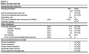 Table 2: Water sources and use. (Source: FAO-Forestry)
 The River Gambia originates in Fouta Djallon in the mountain region of Western Guinea and flows through Senegal before entering the Gambia. Within the country, the River Gambia flows from east to west for about 400 km. It is a major waterway and tourist attraction. Its floodplains, riverbanks, and wetlands are important habitats for wildlife and play an important role in local livelihood strategies. Its flow is highly seasonal. The maximum flow occurs at the end of the rainy season in late September or October with a flow of about 1,500 m3/s; the minimum dry season flow is less than 4.5 m3/s. Both measurements are taken at Gouloumbo in Senegal. Because of the flat topography there is a pronounced marine influence and the river’s seasonality and salinity have important repercussions on land use.
The country’s total actual renewable water resources are estimated at 8 km3/year, of which about 3 km3 are internally produced and the remaining 5 km3 represent the inflow of the River Gambia from Senegal (Table 2). It is estimated that internally produced groundwater amounts to about 0.5 km3/year, all of which is drained by the River Gambia and becomes the base flow of the river. Groundwater is available in all parts of the Gambia. The country is located in one of Africa’s major sedimentary basins and is often referred to as the Mauritania/Senegal Basin. It is characterized by two main aquifer systems with water table depths varying from 10 m to 450 m.
Along the river, the width of the valley varies from 20 to 40 km and three major sections may be distinguished:
- The Upper Valley (UV), where floods occur occasionally and water is always fresh.
- The Central Valley (CV), where tidal influence exists but water is also fresh. In the lower CV water is fresh only during the rainy season while in the dry season, when the salt tongue moves as far as 250 km upstream, it becomes brackish. Thus, in the dry season, about 220 km of freshwater are left in the Central and Upper River Divisions.
- The Lower Valley (LV), where water is perennially saline because of permanent tidal influence.
Water Use
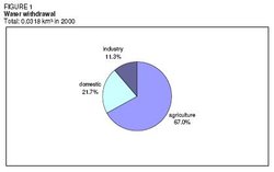 Figure 1: Water withdrawal. (Source: FAO-Forestry)
 Total water withdrawal was 31.8 million m3 in 2000. The largest water user was agriculture with 21.3 million m3/year (67%), followed by the domestic sector with 6.9 million m3/year (22%) and industry with 3.6 million m3/year (11%) (Table 2 and Figure 1).
Surface water is rarely used as a source of potable water in the Gambia, because of the continuously saline conditions which exist in the lower reaches of the River Gambia and its tributaries, where the population centers and tourism facilities are located. The potable water demand for urban areas, tourism, industry, irrigation, and livestock watering is supplied by groundwater sources.
International Water Issues
The Gambia is located entirely within the Gambia River Basin, which is shared between Senegal (77.5% of the basin area), the Gambia (13%), Guinea, (9%) and Guinea-Bissau (0.5%). The Gambia signed several international agreements and conventions regarding the Gambia River Basin, namely:
- Agreement for the integrated development of the Gambia River Basin (1968)
- Convention creating the coordinating committee of the River Gambia (1976)
- Convention relating to the status of the River Gambia (1978)
- Convention relating to the creation of the Gambia River Basin development organization (1978)
Irrigation and Drainage Development
Evolution of Irrigation Development
Irrigation potential in the Gambia was estimated in 1984 to be 80,000 ha. There are several irrigation development projects under way in the country:
- The Jahaly Pacharr Smallholder Project (JPSP) is based at Sapu in the Central River Division (CRD) and has been in operation since 1980. The total irrigated area was 1,409 ha in 1999, including 560 ha double cropping pump-fed and 849 ha tidal rice areas, and benefited some 22,000 people. In the project areas, tidal, and pump irrigation are coordinated. Tidal water is utilized to irrigate low lands nearer the banks of the river while water is pumped from the river to irrigate large areas of land at higher elevations.
- The Rice Irrigation Development Project (RIDEP), which commenced in 1988, has addressed the rehabilitation of a number of pumped irrigation schemes in CRD. The objective was to rehabilitate the numerous deteriorating rice irrigation schemes to provide double cropping and to encourage self-sufficiency in operation and maintenance. It was planned to rehabilitate and develop 1,250 ha and benefit 25,000 people by 1996, but only some 243 ha were in operation by 1999.
- The Small Scale Water Control Project (SSWC) is an IFAD-funded, double cropping tidal scheme also located in CRD which began in 1991 and received support until the end of 1996. The project has emphasized farmer involvement from the outset and the total irrigated area was 482 ha by 1999. There are a number of problems in the scheme including poor water quality (salinity), poor land leveling, maintenance, and water management.
- The Lamin Horticultural Project and the Bakau Horticultural Project are both situated in the Western Division relatively close to Banjul in densely populated areas. Continuous cropping on small irrigated areas produces a more or less constant flow of vegetables for sale. The gardens were developed using donor funds and the emphasis was on women growers. At Bakau, water is obtained by bucket from shallow wells and applied by hand to the surrounding beds. Participants own up to 20 beds each, so that an average plot is between 0.01 and 0.03 ha. At Lamin, a good supply of freshwater is obtained from boreholes using solar power supplemented by a small generator. The garden area is 15 ha of which about half is devoted to individual irrigated vegetable plots and half to a communal orchard.
- The Lowland Agricultural Development Project (LADEP), a 20-year project which began in 1997, is being funded by IFAD and the African Development Bank (AfDB) and aims to develop 3,735 ha of land during the first eight-year stage. To this end, LADEP is involved in the construction of dikes to store freshwater during the rainy season and to prevent flooding with saline water. The freshwater impoundments are used for wet season rice production only. In a second phase, LADEP will explore the potentialities of water control during the dry season.
- The FAO Special Program for Food Security (SPFS) covers the period 2002-2004 and its overall objective is to demonstrate the technical, socio-economic, and environmental feasibility of simple irrigation techniques during the dry season and their positive effects on crop production and food security. It is aimed at using irrigation in order to facilitate a second crop, ensure, and increase the rice yields and diversify crop production by harvesting not only rice but also vegetables. Pumping from shallow tube wells and harvesting the tide where appropriate will also be carried out, in this way complementing the LADEP project. The expected output of the project is the development of four tidal and pump irrigated schemes with a total area of 28 ha. About 4,300 farmers could benefit from the project.
- The Smallholder Irrigation for Livelihood Enhancement (SMILE) project introduces selected irrigation technologies, proven to be successful for small-scale farmers elsewhere in Africa, to woman farmers. Local manufacturers are trained to make good quality irrigation equipment to ensure that as many women farmers as possible can benefit.
- Other ongoing projects are the Farmer Managed Tidal Irrigation Project (FMTIP) and the IFAD-led Integrated Watershed Management Project (IWMP).
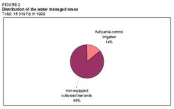 Figure 2: Distribution of the water managed areas. (Source: FAO-Forestry)
 Accurate up-to-date figures on irrigated areas are not available. In 1991, the area equipped for full or partial control irrigation was estimated to be 1,670 ha; this figure might have increased to 2,149 ha by the year 1999, referring to the sum of the JPSP, RIDEP, SSWC, and Lamin-Bakau schemes. In addition, non-equipped wetlands and inland valley bottoms are cultivated and these accounted for approximately 13,170 ha in 1991. These areas represent mangrove swamps and freshwater swamps, where rice is grown from August to January by constructing simple protection dikes. Thus, the total water-managed area is estimated at 15,319 ha or 7% of the cultivated area (Table 3 and Figure 2). All the area equipped for full or partial control irrigation is surface-irrigated, either with pumped schemes (818 ha or about 38% of the area in 1999) or by employing tidal irrigation (1,331 ha or about 62% of the area).
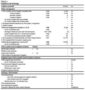 Table 3: Irrigation and drainage. (Source: FAO-Forestry)
 In the low-lying marshy areas tidal flows are employed for irrigation purposes. This is feasible in the middle reaches of the river, beyond the 240 km mark, where river water is not salty. Tidal irrigation is very different from ordinary gravity irrigation or pump irrigation, as it takes advantage of the ocean tides to force river water onto the fields. Tide heights vary from 3.5 m at the mouth of the River Gambia to 0.9 m at Basang, 310 km upstream, and as a general rule tidal irrigation can be used to water marshy fields with an elevation of less than 1.7 m above the average sea level. A water control valve is usually installed where water enters the system, and the system should have separate inlets and outlets. River water is allowed to flow into the system at flood tide, and the outlet valve is shut as the tide ebbs to keep the water on the fields. Areas where tidal irrigation is feasible include Wassu, Kuntaur, Tobakuta, Sukuta, and Bauajali on the north bank, and Sapu, Willirgara, Kuffzally, and Yidda on the south bank in the Middle River Division.
To avoid an increase in salinity, the safe limit for irrigation from the River Gambia, without major dam construction, was estimated to be a maximum of 2,400 ha in the dry season. The lower and lower central river sections (up to Carrol’s Wharf) contain considerable areas of actual and potentially acid sulphate soils.
Role of Irrigation in Agricultural Production, the Economy, and Society
The main irrigated crop is rice. In the Jahaly Pacharr Smallholder Project (JPSP), a high rice yield is achieved in the areas receiving pumped water. Between 4 and 7 tons/ha is expected rather than the 3-4 tons/ha achieved in the tidal areas.
Estimates on the cost of installing irrigation systems vary from US$4,000/ha for tidal irrigation to US$10,000/ha for pump irrigation. Analyses taking into account installation and production costs, the anticipated rice output after implementation, the value of that output, etc., indicate that the profit/cost ratio for tidal irrigation is 2.02, while that for pump irrigation is 0.72. It is evident, therefore, that by using tidal irrigation the Gambia could increase its rice output significantly. Costs for certain water control structures are: about US$3 per meter of dike in the valleys, including labor, and all other inputs; about US$30 per meter of concrete spillway; about US$1 per meter of contour or diversion bund, including the rock dams that are installed in the system at road crossings for example.
In the Gambia, the resources that are made available for irrigation, especially labor, are influenced by a particularly complex network of rights and obligations in rural society. Women in rural communities play an important role in the allocation of family labor to food production tasks. Despite this role, women are often stressed because old traditional obligations are upheld in new situations. The introduction of irrigation, or the technical formalization of existing water-use systems, involves in most communities a change in the traditional farming system. Women are major participants in irrigation at field level, however there is only scant evidence that they participate significantly in water management or policy decisions at the system, regional, or national levels.
The Colonial Development Corporation (CDC) implemented irrigation and development schemes but started the alienation of women’s land rights by assuming that men own the land. This approach ignored the fact that women had significant access to land resources and their benefits from rice farming as well as responsibilities for food and support of children. Post-colonial development schemes made similar mistakes. Irrigated rice projects funded by the World Bank, China, IFAD, etc., be they small- or large-scale double-cropping schemes, ignored the elaborate system of land rights and cropping responsibilities. The women’s land was taken and they were expected to labor on men’s fields. Thus women had no means of generating the same income and maintaining independent decision-making rights over their labor and livelihoods. As a result of this situation, women tend to rebel and refuse to work at certain times of year when they want to work on their own fields, and they form work groups to drive up wage labor. As a consequence, many projects are expensive and unsuccessful.
In the course of the Jahaly Pacharr Smallholder Project (JPSP), the patterns of access to land and distribution of benefits have undergone a number of changes. However, the registration of project land in women’s names has had only a limited impact on the power bases of men and women. In the Rice Irrigation Development Project (RIDEP), training for the operation and maintenance of power tillers is offered to both men and women. However, while the women were enthusiastic, the older men of the village clearly disapproved of women handling power tillers and commented that they did not want women coming home too tired to do other duties.
Gender issues in irrigation in the Gambia can be summarized as follows:
- Decision-making: decisions relating to crop production, e.g. crop selection, are taken by both genders. However, men more often than women take decisions about the inputs to be purchased and the laborers to be hired. Women take decisions relating to the deployment of household labor and marketing. Overall, in the Gambia there is a high level of participation on the part of women in agricultural decisions, but in general women have limited control of the production system.
- Land tenure: irrigated land is commonly owned and inherited, mainly passing down the female line. This pattern follows that of the swamp rice cultivation traditionally undertaken by women. Horticultural gardens are generally considered to be part of the female domain. Vegetables are exclusively grown by women. Women working in the vegetable gardens also cultivate swamp rice in the wet season.
- Income: incomes from rice are generally low because a high proportion of the rice produced is kept to meet the needs of the family. Marketing is often undertaken only to obtain cash for specific payments. Women may offer rice for sale to the men of the compound who will buy it to fulfill their obligation to meet family needs. Women do not necessarily control the benefits in proportion to the work they contribute.
- Water control: responsibility for the application of water to the fields is taken on equally by men and women. The majority of rice growers are female, but water control in rice schemes is mainly managed by men. Women have a strong tradition of rice cultivation and a good but informal skills base. Until recently this experience has been largely ignored.
- Impact of irrigation on women: women claim that they worked much harder than in the past as a result of the introduction of vegetable gardens and improved rice schemes. However, women continue to work in irrigated farming for a number of reasons.
Status and Evolution of Drainage Systems
In tidal irrigation schemes, drainage is the paramount concern during the rainy season; during the dry season, irrigation is the most important consideration. The ditches of a tidal irrigation system must therefore have a dual irrigation/drainage function. It is necessary to prevent irrigation water from flooding the fields, and attention must be paid to controlling irrigation and drainage at the times of flood and ebb tides.
Water Management, Policies, and Legislation Related to Water Use in Agriculture
Institutions
Policy guidance and technical support for agriculture are provided by the Ministry of Agriculture (MOA) through a Central Management Unit and four main departments. The Department of Agricultural Services (DAS) is responsible for Agricultural Extension Services, the Soil and Water Management Unit (SWMU), the Crop Protection Service, the Food and Nutrition Unit, and the Agricultural Communications Unit. The SWMU is in charge of developing policies for soil and water management, land capability zoning, upland conservation, and development of small-scale water control schemes in lowland rice ecologies. It is divided into five sections, one of which - the Engineering Section - is involved in irrigation development.
The Department of Water Resources (DWR) of the Ministry of Natural Resources and Environment (MNR&E) liaises closely with the SWMU.
Water Management
Most farmers involved in irrigation/water management belong to Water User Groups. In the IFAD-led Small-Scale Water Control Project SSWCP, a three-tier organizational structure was established:
- Water Users Groups (WUGs) are the smallest units, which include farmers working adjacent plots in one swamp
- Swamp Development Committees (SDCs), the next level up, oversee water management issues at swamp level
- Local Management Committees (LMCs) are the highest level, including representatives of all villages involved in one scheme (which can include several swamps) to resolve cross cutting and policy issues
However, none of these groups was working properly by the end of IFAD support in 1996 and both project staff and beneficiaries were unclear about responsibilities and work modalities.
Environment and Health
Pumping irrigation water from the River Gambia has a potentially negative impact on the salt front in the river and thus on the environment overall. It has been estimated that if 1 m3/s is pumped from the Upper River during the dry season, the salt front can move up to 4 km upstream.
Deforestation is a problem due to the high and ever-increasing demand for fuel wood.
Perspectives for Agricultural Water Management
Given the low farmgate price of rice, the Government is considering alternative crops such as sugar cane, bananas, and onions to justify investment in the rehabilitation of existing pump irrigation schemes.
By fully developing tidal irrigation and using superior seed rice together with the best cultivation technology, the Gambia can greatly increase output per unit area and even attain self-sufficiency. However, if tidal irrigation is to succeed in increasing the Gambia’s rice output, the following measures are required:
- Farmers must be trained in effective rice cultivation techniques
- Farmers must learn to control and use tidal irrigation
- Farmers must be encouraged to change their attitudes and receive training in the use of draft animals to replace human labor, as a means of reducing costs and increasing profits
- Farmers’ associations or similar organizations need to be established or strengthened, and cooperation improved
- Irrigation or similar associations should be established and given responsibility for managing water resources and irrigation operations and for extending irrigation facilities within their districts. These duties are currently being performed by the implementing units of the various projects, but the work is not achieving as good results as might be possible.
National policies give high priority to increased rice production using technologies which are environmentally sound and sustainable without subsidies. The Government also gives high priority to food security and poverty alleviation within the context of sustainable development.
Further Reading
- Water profile of Gambia, Food and Agriculture Organization.
- World Factbook: Gambia, Central Intelligence Agency.
- Central Statistics Department, Ministry of Finance and Economic Affairs. 1993. Statistical abstract of the Gambia 1992.
- Chancellor, F. 1996. Women in Irrigation: Case studies of schemes in the Gambia, Kenya and South Africa. HR Wallingford, UK. Report no OD/TN 82.
- Department of Planning, Ministry of Agriculture. 1991. Statistical yearbook of Gambian agriculture 1990.
- Department of State for Finance and Economic Affairs. 2002. Strategy for Poverty Alleviation (SPA II). Strategy for Poverty Alleviation Coordinating Office. The Republic of the Gambia.
- FAO. 1982. The Gambia: Water resources development in the framework of the National Food Plan. Report prepared by P. Pallas and S. N’Guiamba for FAO project TCP/GAM/0104. Rome.
- FAO. 1984. Agricultural Research in the Gambia River Basin. Rome.
- FAO. 1994. The Gambia: Lowlands Agricultural Development Programme. FAO Investment Centre/IFAD Cooperation Programme report Nº 52/94 IFAD-GAM 15. Rome.
- FAO. 1997. Treaties concerning the non-navigational uses of international watercourses: Africa. FAO Legislative Study 61. Rome, Italy.
- FAO. 2001. The Gambia: Lowlands Agricultural Development Programme. Socio-economic and production systems study. Project document.
- FAO. 2002. Water Control Component of the Special Programme for Food Security. TCP/GAM/2801 (D). Project Document.
- International Cooperation and Development Fund (ICDF). 1999. Tidal Irrigation in the Gambia. In: ICDF. 1999 ICDF Annual Report - Special Report. 67-70.
- Njie, M., and Mikkola, H. 2002. Management and development of the Gambia River fisheries: A case for the co-management of inland fisheries resources. In: Geheb, K., and Sarah, M.T. (eds.). Africa’s inland fisheries: the management challenge. Fountain Publishers. Kampala. 228ff.
- Sonko, E.O. 2001. Gambian experience in water harvesting. In: FAO. Water harvesting in western and central Africa. Proceedings of a regional workshop held in Niamey, October 1999. Accra, Ghana. 103-108.
- UNEP. 1998. Tidal Irrigation, the Gambia. In: UNEP. Sourcebook of Alternative Technologies for Freshwater Augmentation in Africa. Technical Publication 8a.
| Disclaimer: This article is taken wholly from, or contains information that was originally published by, the Food and Agriculture Organization. Topic editors and authors for the Encyclopedia of Earth may have edited its content or added new information. The use of information from the Food and Agriculture Organization should not be construed as support for or endorsement by that organization for any new information added by EoE personnel, or for any editing of the original content. |