Water profile of Eritrea
Contents
- 1 Geography, Climate, and Population
- 2 Economy, Agriculture, and Food Security
- 3 Water Resources and Use
- 4 Irrigation and Drainage Development
- 5 Water Management, Policies, and Legislation Related to Water Use in Agriculture
- 6 Environment and Health
- 7 Perspectives for Agricultural Water Management
- 8 Further Reading
Geography, Climate, and Population
 Map of Eritrea. (Source: FAO)
 Eritrea covers an area of 117,760 square kilometers (km2) and has a coastline of over 1,000 kilometers (km). It is situated in the Horn of Africa, neighboring Sudan, Ethiopia, and Djibouti and bordered to the East by the Red Sea. The total cultivable area is estimated at around 1.6 million hectares (ha). The total cultivated area was 503,000 ha in 2002, of which 500,000 ha arable land and 3,000 ha permanent crops (Table 1). Most of the country consists of savanna, steppes, and desert, particularly in the south-western lowlands and in the east near the Red Sea. The highlands, where altitudes range between 1,500 and 2,000 meters (m), are among the oldest areas cultivated by humans and are showing signs of overuse. Administratively, Eritrea is divided into six zobas. Six different major agro-ecological zones can be distinguished, with crop production being concentrated on the moist highlands and the lowlands (Table 2).
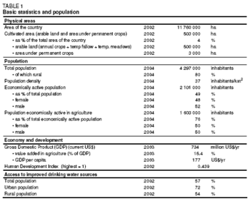 Table 1: Basic statistics and population. (Source: FAO)
 Eritrea is located in the Sahelian rainfall zone, with rainfall provided by the south-western monsoons. Climate ranges from hot and arid near the Red Sea to temperate sub-humid in the eastern highlands. Average annual rainfall is about 380 millimeters (mm), varying from less than 50 mm to over 1,000 mm. Over 90% of the total area receives less than 450 mm and only 1% receives more than 650 mm of annual rainfall. Rainfall in Eritrea is torrential, of high intensity, short duration, and varies greatly from year to year. The rainy season for the highlands and western region extends from June to September. As a result of the topographically ragged nature of the highlands, thin soil formations and a completely deforested terrain, most of the runoff turns into violent flash floods. Mean temperature varies between the agro-ecological zones, ranging from 18°C in the highlands to 35°C in the lowlands. Annual evapotranspiration rates range from 1,900 mm in the northern Red Sea coastal basin and plains, to 1,700-2,000 mm in the northern highlands and 8,000 mm in the Gash-Barka basin.
Total population was estimated at almost 4.3 million in 2004, with a population growth rate of 2.1% in 2003. Demographic growth in Eritrea will be mostly from the resident population, but also from repatriated refugees. National population density reaches 37 inhabitants/km2. Although the highlands comprise only 19% of the land surface, 65% of the population is settled there. Only about 20% of the population lived in urban areas in 2004. Safe drinking water was available to 57% of the population in 2002 (72% in urban areas and 54% in rural areas) (Table 1). Life expectancy was 52 years in 2002. Net primary school enrollment was 61%. About 7 in 10 persons live below the minimum standard of living threshold and 66% of the population is estimated to be poor.
Economy, Agriculture, and Food Security
Eritrea’s economy in general and the agricultural sector in particular were seriously affected by the combination of war, recurrent droughts and degraded lands. Agriculture, which is based on smallholder farming, accounted for 15% of Gross Domestic Product (GDP) in 2003. Up to 80% of the population depends on farming. Currently the food supply is highly dependent on imports and food aid. The contribution of agriculture to the trade (Free trade) balance is negative. The contribution of the sector to exports and imports was 7% and 11% respectively in 2001. Food imports as a result of food shortages amounted to 20% of total imports between 2001 and 2002. The main agricultural product imported in 2001 was wheat (46% of all imports) and the main exports were sesame seeds and flour (89% of all exports).
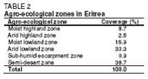 Table 2: Agro-ecological zones. (Source: FAO)
 The main factors constraining crop production are low total rainfall and its distribution, insufficient availability of plowing animals, problems of access to quality seeds, rapid degradation of land and water resources owing to soil and water erosion, inefficient agricultural extension services, and poor or inadequate rural infrastructures.
The farming system comprises:
- Rainfed crop systems using traditional methods with very low input levels, mainly in the central and southern highlands
- Irrigated agriculture systems using mainly spate irrigation in the western and eastern lowlands
- Agro-pastoralist and nomadic pastoralist systems, mainly in the lowlands and escarpment zone (agro-pastoralists derive their livelihoods from cattle, sheep, and goats, while nomadic pastoralists often keep camels as well)
Water Resources and Use
Water Resources
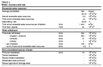 Table 3: Water sources and use. (Source: FAO)
 Three main drainage systems can be distinguished:
- The Mereb-Gash and Tekeze-Setit River systems, draining into the Nile River
- The eastern escarpment and the Barka-Anseba River systems, draining into the Red Sea
- The river systems of a narrow strip of land along the south-eastern border with Ethiopia, draining into the closed Danakil Basin
Although no measurement of runoff is available, the internally produced renewable water resources are estimated at around 2.8 km3/yr, most of which are located in the western part of the country.
There is only one perennial river, the Setit River, which also forms the border with Ethiopia. All other rivers are seasonal and contain water only after rainfall and are dry for the rest of the year. There are no natural fresh surface water bodies in the country. Artificially dammed water bodies are found here and there in the highland parts of the country.
Groundwater can be tapped in all parts of the country but not in the quantities and of the qualities desired. Four hydro-geological units, based on the different geological units, recharge conditions and hydraulic characteristics, can be detailed:
- Granular aquifers, which cover large areas in the western and eastern lowlands and along river valleys and flood plains. Unconsolidated aquifers consisting of the alluvial and colluvial sediments are also found in the Asmara area, Red Sea [[coastal] plains] and at the foot of fault scraps and mountains
- Fissured and jointed volcanic aquifers, which are found in the central highland plateau southeast of Asmara and west of Assab, the Alid hot spring and in the southern part of the country
- Fissured and karstic aquifers of consolidated sedimentary rocks, limestone, coral reefs, evaporate deposits and the marbles of metamorphic assemblages
- Fissured aquifers of the basement rocks of crystalline metamorphic rocks and associated intrusive rocks, which are localized along weathered (Soil erosion and deposition) and fractured zones, with limited groundwater resources
The recent water point inventory counts 5,365 water points. About 3,374 are unprotected dug wells and 1,233 are contaminated surface water points. Typical borehole depths are in the range of 20 to 70 m. Deep aquifers are not known. Problems of groundwater depletion have been reported in various parts of the country. Apparently there are a few natural springs, but an inventory is not available.
Currently there are about 187 dams with reservoirs having a capacity of over 50,000 cubic meters (m3) each. About 42% are for domestic use and irrigation, 40% for domestic use only, 13% for irrigation, and 5% are not used. The total capacity reaches 94 million m3.
Water Use
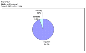 Figure 1: Water withdrawal. (Source: FAO)
 Groundwater is the basis of domestic water supply. Total water withdrawal was estimated at 582 million cubic meters (m3) in 2004, of which 550 million m3 for agriculture (94.5%), 31 million m3 for domestic consumption (5.3%) and 1 million m3 for industry (0.2%) (Table 3 and Figure 1).
The quantity of municipal wastewater can be estimated at 50,000 m/day. Treatment of municipal and industrial effluents has not yet begun.
International Water Issues
Eritrea is part of the Council of Ministers of Water Affairs of the Nile Basin States (Nile-COM) as an observer, together with Burundi, the Democratic Republic of the Congo, Egypt, Ethiopia, Kenya, Rwanda, Sudan, the United Republic of Tanzania, and Uganda. It is a prospective member of the Nile Basin Initiative. The Setit and Mereb-Gash rivers are shared with Ethiopia.
Irrigation and Drainage Development
Evolution of Irrigation Development
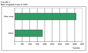 Figure 2: Main irrigated crops since 1993. (Source: FAO)
 Estimates of irrigation potential vary from 107,000 ha to 567,000 ha, the latter not taking into account the water availability. Based on water availability, it can be estimated at 187,500 ha.
In 1993, an estimated 4,100 ha was under perennial irrigation from reservoirs, springs, and wells, irrigating mainly fruits, vegetables, and cotton (Table 4 and Figure 2):
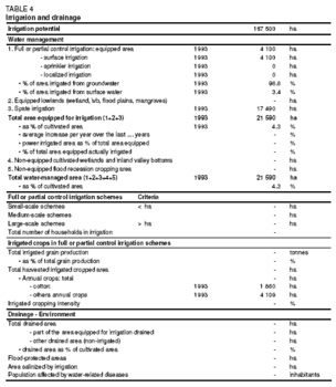 Table 4: Irrigation and drainage. (Source: FAO)
 - Approximately 1,300 ha were irrigated through the pumping of shallow groundwater along the Gash and Barka [[rivers] *Some 140 ha comprised the Elaberet and Mai Aini citrus/horticultural plantations presently under government management
- About 2,590 ha were cropped by small farmers in the highland provinces mainly through the pumping of groundwater from open wells
- The balance of 70 ha was irrigated from springs
The area equipped for spate irrigation covers 17,490 ha, of which 15,650 in the eastern lowlands and 1,840 ha at Alighider on the lower Gash and a small area along the Barka. The traditional technique of spate irrigation depends on the diversion of floods, a resource that is available at irregular and unpredictable intervals and only for a few hours at a time. The contribution of the spate irrigation to total crop production is negligible.
Water Management, Policies, and Legislation Related to Water Use in Agriculture
Institutions
The institutions involved in water resources management are:
- The Ministry of Land, Water and Environment (MoLWE) with the Water Resources Department (WRD), which has the followings functions according to the Draft Water Law (1997):
- Assess and evaluate the water resources’ potential of the country
- Function as a resource center for water-related data/information
- Manage and develop national water resources
- Evaluate, monitor, and supervise all water-related studies, development projects, and programs of national interest
- Grant, manage, and inspect the implementation of water permits and waste discharge permits.
The Ministry’s mandate further includes legislation, and establishing a system of water rights and obligations. The WRD is divided into two divisions according to these two different tasks: Water Resources Management and Use Division and the Water Resources Assessment Division. As regards water supply, the WRD initially served the entire country, even including maintenance and repair of equipment, but services have been decentralized since 1996. The problem is that the regional authorities, which are now responsible for the implementation and maintenance of rural water supply projects, do not have the capacity to effectively take over this responsibility and several units of the WRD are therefore still involved in local project implementation
- The Ministry of Agriculture (MoA) and its Soil Conservation and Irrigation Development Unit, which is part of its Department of Land Resources and Crop Development
- The Ministry of Local Government (MoLG), responsible for the Regional Administrations
- The Ministry of Health (drinking water supply)
- The Ministry of Transport and Communication, through its mandate for meteorological data collection
Policies and Legislation
All land was brought under state ownership by the Land Proclamation of 1994. This law provides farmers with a lifetime right of usufruct over currently held land, removing the previous risk of periodic redistribution. Land is not inheritable and cannot be sold, but it can be leased. Lessees have to use the land leased to them if they are to maintain their rights.
In 2003, the Draft National Water Policy Framework (1997) was still not officially adopted. A recent effort to formulate water policies and strategic approaches is the report titled "Planning, management & advocacy tools for rural water resources development", which is the result of an inter-ministerial workshop in Asmara. This framework defines the following policy objectives:
- Provision of safe, adequate, and accessible water for all
- Improved coverage of appropriate sanitation in both urban and rural areas
- Integrated management and fair allocation of the available water resources to meet the needs of all sectors of the population
- Assessment, conservation, regulated utilization and quality protection (that is, maintenance or enhancement) of all water resources, and also the mitigation of water-related hazards
- Economically and environmentally sound and sustainable water resources development, according to a prioritized schedule
The Draft Water Law, in preparation since 1996, was still to be finalized and adopted in 2003. No formal legislation and no formal system of permits or licenses are in place and local traditional customs prevail. For example, the communities affected by water shortage have the right to benefit from an available supply in their nearest neighborhood. In principle, water is public property and controlled by the government. However, national or regional plans do not exist and the ground rules for the actual water allocation are not clearly defined. Because of the lack of a promulgated, effective water law, activities in the water sector are still uncoordinated.
A draft strategy document on rural water supply and sanitation was drawn up between 1995 and 1997 and its final report was issued in December 2000. Unfortunately this document has never been officially endorsed or adopted.
Environment and Health
Salinity problems are present in most aquifers in the [[coastal] areas]. Generally, the salinity levels increase with the distance from the recharge area (the foothills of the eastern escarpment) and seawater intrusion has reportedly been observed up to about 20 km inland. Several saline geothermal springs are present along the eastern escarpment. Salinity is also common in the northwestern lowlands.
Fluoride concentrations exceeding international limits have been found mainly in the Anseba region and are probably related to the presence of certain rock types.
Bacteriological contamination is very common as many water points are not protected or are not at a sufficient distance from sources of pollution. Between 40% and 90% of the water sources analyzed during the Rural Water Point National Inventory have been found to be biologically contaminated in the various regions.
Pollution problems are basically related to domestic sewage. A large part of the groundwater in the Asmara area has a very high nitrate (Nitrogen) content, which is due to the effects of the many latrines located in the town. Industrial pollution as well as irrigation-related pollution is not yet a problem because of the limited activities of the two sectors.
Malaria incidence and prevalence are increasing. Malaria affects about 67% of the population and forms about 30% of total outpatient morbidity. It is the major cause of morbidity and mortality of women and children. P.falciparum is the cause of 94% of all cases of malaria.
Perspectives for Agricultural Water Management
The WRD/UNICEF report of 2003 "Eritrea - Planning, management & advocacy tool for rural water resources development" mentions a goal of safe water sources coverage of 60% of the rural population by 2015.
Irrigation-related objectives on the 2010 horizon are to add 20,000 ha by the construction of small dams and wells, development of joint irrigation-hydropower schemes, and a survey of the water resources. The WRD also has plans and strategies to introduce cost-effective and environmentally-friendly water technologies and sustainable water supply management systems.
Water resources availability does not seem to be the immediate constraint. The problem is mainly the absence of a water policy and effective institutional capacity to manage the water. Another constraint is the lack of legislation to regulate water control in respect of both supply and demand. At present, much of the scarce water is being wasted due to lack of management. One of the challenges of the management will be to cope with the high variability of the availability of resources.
Further Reading
- Water profile of Eritrea, Food and Agriculture Organization.
- World Factbook: Eritrea, Central Intelligence Agency.
- FAO. 1993. Eritrea - Agricultural sector review and project identification. TCP/ERI/2353.
- FAO. 1995. Eritrea - Special programme on food production for food security in low-income food-deficit countries. Exploratory mission report.
- FAO. 2000. Eritrea - World Food Summit follow-up. Strategy for national agricultural sector. Horizon 2010.
- FAO. 2001. Water resources management. TCP/ERI/0169.
- FAO. 2003a. Water resources monitoring in Eritrea. Consultancy Report by R. Seidelmann - Project TCP/ERI/0169.
- FAO. 2003b. Eritrea - Strategy brief for national food security and agricultural development. Horizon 2015.
- Geraghty P., Temnewo, G. 2000. Water resource development and management in Eritrea. Proceedings of IWRA’s Xth World Water Congress, Melbourne, 2000/03/12-2000/03/16.
- MoA. 2002. National report on the implementation of the UNCCD.
- MoA. 2004. National report on the implementation of the UNCCD.
- Stillhardt B., Ghebru B., Mehari Haile, A. 2003. Small-scale micro-irrigation in Eritrea. World Bank. 1996. Proceedings of the World Bank sub-Saharan Africa water resources technical workshop, Nairobi, Kenya, 1996-02-12 / 1996-02/15.
- UNEP. 2001. Overview of the socio-economic aspects related to the management of municipal wastewater in west Asia (including all countries bordering the Red Sea and Gulf of Aden).
- UNEP. 2005. Assessment and mapping of the water resources in the IGAD sub-region. Consultancy report. (as yet unpublished).
| Disclaimer: This article is taken wholly from, or contains information that was originally published by, the Food and Agriculture Organization. Topic editors and authors for the Encyclopedia of Earth may have edited its content or added new information. The use of information from the Food and Agriculture Organization should not be construed as support for or endorsement by that organization for any new information added by EoE personnel, or for any editing of the original content. |