Water profile of Bangladesh
Contents
Geography and population
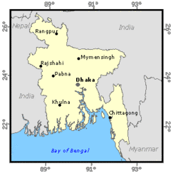
Bangladesh (24°00' North, 90°00' East) is located in southern Asia, in the northeast of the Indian subcontinent, and covers a total area of 144,000 km2. It has a common border in the west, north and east with India, a short border with Myanmar in the southeast, and is bounded by the Bay of Bengal in the south. Administratively, the country is divided into 6 divisions, 64 districts and 490 thanas. There are four metropolitan areas including the capital city, Dacca.
The country is flat with some uplands in the northeast and southeast. A great plain lies almost at sea level along the southern part of the country and rises gradually towards the north. The land elevation in the plain varies from 0 to 90 meters (m) above sea level. The maximum elevation is 1,230 m above sea level at Keocradang in the Rangamati hill district. The geomorphology of the country consists of a large portion of floodplains (79.1%), some terraces (8.3%) and hilly areas.
The total cultivable area is estimated at 8,774,000 hectares (ha), which is about 61% of the total area. In 1994, the total cultivated area amounted to 7,743,000 ha, 392,000 ha under permanent crops. Of the area cultivated under annual crops, about 19% was single cropping, 59% double cropping and the remaining 22% triple cropping. In 1994, due to double and triple cropping, the total area of crops amounted to about 13.5 million ha, giving an average intensity of 154%. Subsistence farming practices characterize agriculture in Bangladesh. Cereals, occupying nearly 11 million ha or 76% of the total area in 1994, are the most important annual crops, with rice alone representing more than 10 million ha. Other annual crops are pulses, oilseeds, jute and sugar cane. The average holding per farm household was 0.9 ha in 1983. Nearly 24% of farm households own less than 0.2 ha and another 46% own up to 1.0 ha.
In 1996, the population of Bangladesh was estimated at 120,073,000 inhabitants (81% rural) with an annual growth rate of 1.88%. Bangladesh is one of the most densely populated countries in the world with about 834 inhabitants/km2. The agriculture sector continues to play an important role in the economy of the country. It accounts for about 30% of gross domestic product (GDP) and 61% of overall employment, 57% of the labor force being directly engaged in farming activities.
Climate and water resources
Climate
Bangladesh has a tropical monsoon climate with significant variations in rainfall and temperature throughout the country. There are four main seasons: the pre-monsoon (March-May) has the highest temperatures and experiences the maximum intensity of cyclonic storms, especially in May; the monsoon (June-September) when the bulk of rainfall occurs; the post-monsoon (October-November) which, like the pre-monsoon season, is marked by tropical cyclones on the coast; and the cool and sunny dry season (December-February).
The mean annual temperature is about 25° C, with extremes of 4 and 43° C. Ground frosts can occur in the hills. Humidity ranges between 60% in the dry season and 98% during the monsoon.
About 80% of the total rainfall occurs in the monsoon, and the average annual rainfall over the country is 2,320 mm. Precipitation varies from 1,110 mm in the west to 5,690 mm in the northeast. The country is regularly subjected to drought, floods and cyclones.
River basins and water resources
Most of Bangladesh is located within the floodplains of three great rivers: the Ganges, Brahmaputra and Meghna, and their tributaries, such as the Teesta, Dharla, Dudhkumar, Surma and Kushiyara. The three major river systems drain to the Bay of Bengal through Bangladesh:
- The Brahmaputra River enters Bangladesh from the north and flows south for 270 km to join the Ganges River at Aricha, about 70 km west of Dacca in central Bangladesh.
- The Ganges River flows east-southeast for 212 km from the Indian border to its confluence with the Brahmaputra, then as the Padma River for about a further 100 km to its confluence with the Meghna River at Chandpur.
The Meghna River flows southwest, draining eastern Bangladesh and the hills of Assam, Tripura and Meghalay of India to join the Padma River at Chandpur. The Meghna then flows south for 160 km and discharges into the Bay of Bengal.
The combined discharge of the three main rivers is among the highest in the world. Peak discharges are of the order of 100,000 m3/s in the Brahmaputra, 75,000 m3/s in the Ganges, 20,000 m3/s in the upper Meghna and 160,000 m3/s in the lower Meghna.
Out of the 230 water courses in the country, 57 are transboundary rivers coming essentially from India and about 93% of the catchment areas of the rivers are located outside the country. On average, 1,105.612 km3 of water cross the borders of Bangladesh annually, 85% of it between June and October. Around 54% (598.908 km3) is contributed by the Brahmaputra, 31% (343.932 km3) by the Ganges and nearly 15% (162.772 km3) by the tributaries of the Meghna and other minor rivers.
Because of the great disparity between the monsoon floods and the low flow during the dry season, the manageable surface water resources are considered as equal to 80% of the dependable flow in March. Surface water resources are used extensively for dry season irrigation.
The internal renewable surface water resources are estimated at 105 km3/year. This includes 84 km3 of surface water and about 21 km3 of groundwater resources produced within the country, although part of the groundwater comes from the infiltration of surface water with an external origin. The total renewable water resources are therefore estimated at 1,210.6 km3.
India controls the flow of the Ganges River through a dam completed in 1974 at Farraka, 18 km from the border with Bangladesh. This dam was a source of tension between the two countries, with Bangladesh asserting that the dam held back too much water during the dry season and released too much water during monsoon rains. A treaty was signed in December 1996 under which Bangladesh is ensured a fair share of the flow reaching the dam during the dry season.
Dams and lakes
In 1991, the total dam capacity was estimated at 20.30 km3. In addition, there are three barrages across the Teesta, Tangon and Manu rivers which are used as diversion structures for irrigation purposes only.
In 1995, the installed capacity of all the country's power plants was about 2,907 megawatts (MW), of which about 230 MW was hydroelectric.
Water withdrawal
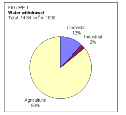
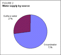
In 1990, the total water withdrawal for agricultural, domestic and industrial purposes was estimated at about 14.64 km3, of which about 86% was for agriculture (Figure 1). Other water uses, including navigation and fisheries, were estimated at 10 km3. Approximately 73% of the total water withdrawal comes from groundwater (Figure 2).
Arsenic contamination
In recent years, great concern has been expressed about the occurrence of arsenic in groundwater-based drinking water supplies at levels well above World Health Organization (WHO) standards. The phenomenon is concentrated in the upper aquifer (10-120 m) and is widespread in the southwest and the Meghna estuary area, affecting up to 75% of all wells in some areas.
Irrigation and drainage development

In Bangladesh, the expansion of minor irrigation (small-scale irrigation) is a vital component of the Government's agriculture strategy. Irrigation through major canals (large-scale irrigation) covers only 6% of the total irrigated area, the remainder being classed as minor irrigation consisting of low lift pumps (LLPs: power-operated centrifugal pumps drawing water from rivers, creeks and ponds), shallow tube-wells (STWs: with a motorized suction mode pumping unit), deep tube-wells (DTWs: with a power-operated force mode pumping unit), manually operated pumps (MOPs: extracting water from a shallow tube-well) and traditional systems. At the end of the dry season, the water level falls beyond the suction limit of the centrifugal pump. In these situations, it is possible to draw water by placing the STW in a pit. An STW in a pit is called a deep-set shallow tube-well (DSSTW) or a very deep-set shallow tube-well (VDSSTW). Where static water levels fall further (over 10.7 m), a submersible or vertical turbine (FMTW: force mode tube-well) is needed.
Between 1950 and 1987, public tube-wells, regulations governing private installations and public monopolies in the supply of pumps, motors and other equipment were a constraint on the development of irrigation. Since 1972, the emphasis has been on minor irrigation through low lift pumps and tube-wells (STWs, DTWs and FMTWs).
From 1979 to 1984, there was a liberalized expansion of minor irrigation, mainly with STWs in the private sector. In 1982, about 1.5 million hectares (ha) were under food crop irrigation. The rate of minor irrigation development slowed from 39,000 STWs in 1984 to less than 5,000 in 1986. This was due to a number of reasons: private sector STW sales were limited; there was official concern over reported declines in groundwater levels where STWs operated; an embargo on all diesel engines was imposed (1985); and engines were standardized (Figure 3).
In 1991, the National Minor Irrigation Development Project (NMIDP) was established in response to the needs of farmers and the requirement for increased private sector investment in minor irrigation technologies. The project activity mainly concentrated on VDSSTW and FMTW technology, whereas irrigation by STW was mainly controlled by the private sector.
In 1994, 665 VDSSTWs and 32 FMTWs had been constructed by farmers as a result of the promotional action of the project. However, there has been a general reduction in the area irrigated by wells as a consequence of aquifer drawdown, and there has been an increase in salinity intrusion particularly along the coastal areas in the southwest of the country. The area salinized by irrigation was estimated at 100,000 ha in 1991.
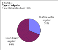
Currently, the irrigation potential is estimated at 7,550,000 ha, of which about 3,751,045 ha had been brought under irrigation by 1995 (Table 1). Irrigation through major canals covers only 9.5% of the total area, the remainder being classified as minor irrigation (Figure 4).
Irrigation by type of water control in 1995
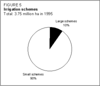
In 1995, the total area equipped for full/partial irrigation covered by large irrigation schemes (major irrigation) was estimated at 355,000 ha. Small irrigation schemes covered a total area of 3,396,045 ha (Figure 5).
In 1992, the average cost of irrigation development was estimated at US$522/ha for large schemes, and US$48.43/ha for small schemes. The average cost for Operations and Maintenance (O&M) was estimated at US$10.52/ha/year.
| Table 1: Types of irrigation and irrigated area | ||
|---|---|---|
| Type of water control | Irrigated area in ha |
% of total |
| Surface water | ||
| Gravity flow | 355,000 | 9.5 |
| LLP (including floating pump) | 577,216 | 15.4 |
| Traditional (manual pumping) | 226,363 | 6.1 |
| Subtotal | 1,158,579 | 31 |
| Groundwater | ||
| STW, DSSTW, and VDSSTW | 2,004,500 | 53.4 |
| DTW and FMTW | 537,865 | 14.3 |
| Unmechanized (HTW) | 50,101 | 1.3 |
| Subtotal | 2,592,466 | 69 |
| Total | 3,751,045 | 100 |
At present, irrigation is practiced for boro rice (71%) and wheat (9%), which together occupy 80% of the irrigated land. Irrigation is mainly used in the dry season. Supplementary irrigation could appreciably increase transplanted aman rice production. The total harvested irrigated area is thus estimated at 3,256,889 ha, which does not include wet season crops on areas equipped for full or partial control irrigation. The irrigated paddy yield was moderately high at 4.4 t/ha. In 1994, total HYV boro rice production amounted to 6.2 million t. The total irrigated grain production amounted to 12.4 million t, which represented about 47% of the total grain production.
Because of its low-lying topography, about 22% of the area of the country is flooded each year. Flood control and drainage are used to reduce the depth of flooding or eliminate, through 'controlled flooding', high and untimely floods in order to provide greater security for crop production.
In 1964, a master plan for water resources development was developed. This envisaged the development of 58 flood protection and drainage projects covering about 5.8 million ha of land. Three types of polders were envisaged: gravity drainage, tidal sluice drainage and pump drainage.
Flood control and drainage projects have accounted for about half of the funds spent on water development projects since 1960. They include:
- major projects such as the Coastal Embankment Project (949,000 ha), the Manu River Project (22,500 ha), the Teesta Right Embankment (39,000 ha), the Ganges-Kobadak Project (141,600 ha), the Brahmaputra Right Flood Embankment (226,000 ha), the Chandpur Irrigation Project (54,000 ha), and the Chalan Beel Project (125,000 ha);
- medium-scale projects such as the Sada-Bagda, Chenchuri Beel and Bamal-Salimpur-Kulabasukhali projects implemented under the Drainage and Flood Control Projects (DFC I to DFC IV) and financed by the World Bank. These projects typically cover areas of 10,000-30,000 ha and involve flood control and drainage with limited irrigation development;
- small-scale projects such as those implemented under the Early Implemented Project, the Small-scale Irrigation Project and the Small-scale Drainage and Flood Control Project.
In 1993, the total area of wetlands was 3,140,000 ha, of which 1,545,000 ha were cultivated and 1,383,000 ha were drained through surface drains. In addition, the irrigated areas equipped for drainage represented about 118,400 ha. In 1992, the average cost of drainage development was US$192/ha.
Different types of floods occur in Bangladesh. Of the total cropped area, about 1.32 million ha are severely flood-prone and 5.05 million ha are moderately flood-prone. The flood-protected area in 1990 was estimated at 4,200,000 ha.
Institutional environment
Public sector involvement in irrigation in Bangladesh is shared between the Ministry of Agriculture (MOA) and the Ministry of Local Government, Rural Development and Co-operatives (LGRD), with jurisdiction over minor irrigation, and the Ministry of Water Resources (MOWR), with jurisdiction over all other forms of water management.
The MOA is mainly concerned with agricultural policy development, planning and monitoring. Project delivery is the responsibility of its various agencies, the most important being the Bangladesh Agricultural Development Corporation (BADC). In the past, the BADC had been directly involved in input supply. It is now withdrawing from all commercial operations relating to minor irrigation, leaving them to the private sector. The Department of Agriculture Extension demonstrates and extends information to farmers on crops, varieties and agronomic practices for irrigated agriculture.
The Water Resources Planning Organisation (WARPO), under the Ministry of Water Resources, has a mandate to ensure coordination of all relevant ministries through the National Water Council and to plan all aspects of water development including major and minor irrigation, navigation, fisheries and domestic water supply.
The Bangladesh Water Development Board (BWDB) is responsible for the planning, implementation and operation of small-, medium- and large-scale flood control, drainage and irrigation schemes.
Two other types of institutions are involved in irrigation: the nationalized banks, and several private cooperatives managed by government. The banks are supposed to make loans to farmers for the purchase of minor irrigation equipment. The Bangladesh Rural Development Board (BRDB) guides the development of two-thirds of the national cooperative system.
The country is divided into five regions for water management purposes.
Trends in water resources management
Water management and flood protection occupy a critical position in any perception of planning for the development of the country. The strategy of the Government is divided into two parts: the short-term period extending over five years, and the long-term period. A combination of short- and medium-term strategies involving both the public and private sector includes:
- maximum utilization of existing facilities through command area development and effective O&M of existing projects;
- de-siltation of rivers and channels;
- adoption of an integrated basin/sub-basin approach in the design of new flood control drainage (FCD) and flood control drainage and irrigation (FCDI) projects in order to avoid interference with natural flood flows;
- adoption of conjunctive use of water resources in planning further development; and
- greater emphasis on the participation of beneficiaries in the planning and design of new projects so as to encourage ownership, particularly with respect to O&M.
Indicative targets have been set for irrigation, as shown in Table 2.
| Table 2: Irrigation targets, 1995-2010 (000 ha) | ||
|---|---|---|
| Irrigation | Target for 2000 |
Target for 2010 |
| Surface water | ||
| Gravity | 466 | 785 |
| LLP including floating pump | 1,250 | 1,500 |
| Traditional | 230 | 200 |
| Groundwater | ||
| DTW | 600 | 600 |
| STW | 2,200 | 2,200 |
| HTW | 20 | 30 |
| FMTW | 100 | 300 |
| DSSTW | 90 | 225 |
| VDSSTW | 38 | 110 |
| Total | 4,959 | 7,050 |
Public sector involvement will remain an important aspect of future development, particularly with respect to:
- the development of suitable on-farm water management packages to improve water use efficiencies and the dissemination of such information through the extension service (the present water distribution efficiency of STW and DTW is 60%);
- the organization of a comprehensive monitoring system of different groundwater zones to ensure that water abstractions remain consistent with recharge;
- characterization of the aquifer and tests for improved well design and development;
- improved design efficiency of pumping units;
- promotion of effective extension services on the selection, repair and maintenance of irrigation facilities and demonstrations of integrated irrigation and mechanization technologies in intensive and diversified farming systems.
Due to the lowering of the groundwater levels in the dry season, the share of DSSTWs, VDSSTWs and FMTWs is expected to increase. DTW technology will disappear as farmers prefer to arrange irrigation on an individual basis or though small group of farmers. DSSTWs, VDSSTWs and FMTWs will cover 45% of the irrigated area in Bangladesh by 2025.
In addition, based on past experience, the National Water Management Plan (NWMP) currently being prepared emphasizes environmental protection and improved data management.
Following the signing of the Ganges Water Treaty in December 1996, planning has now started on developing projects to use water from the river, initially for the relief of the environmental problems in the southwest and ultimately for the expansion of surface water irrigation based on the rejuvenation of the rivers of the southwest and on abstraction by low lift pumps.
Further Reading
- Water Profile of Bangladesh, Food and Agriculture Organization.
- The World Factbook: Bangladesh, Central Intelligence Agency.
- Bangladesh Bureau of Statistics. 1994. Yearbook of agricultural statistics of Bangladesh, p.273. Dacca.
- Bangladesh Bureau of Statistics. 1995. Statistical pocketbook, p. 377. Dacca.
- Bangladesh Bureau of Statistics. 1996. Statistical yearbook.
- Bangladesh Bureau of Statistics. 1997. Statistical bulletin Bangladesh, p. 167. Dacca.
- FAO. 1996. Modernization of irrigation schemes: past experiences and future options, p. 154-164.
- Iqbal, A. 1997. State of land, water and plant nutrition resources in Bangladesh, p.19.
- Ministry of Agriculture. 1996. Bangladesh food and agriculture: World Food Summit, p. 26. Rome.
- National Irrigation Development Project. 1994. Modernization of irrigation schemes in Bangladesh, p. 155-165. Dacca.
- Sir William Halcrow & Partners Ltd. 1997. National minor irrigation census, Bangladesh 1995/96 irrigation season, p. 21. Government of Bangladesh, Ministry of Agriculture.
- Statistisches Bundesamt. 1992. Landerbericht Bangladesh, p. 117.
| Disclaimer: This article is taken wholly from, or contains information that was originally published by, the Food and Agriculture Organization. Topic editors and authors for the Encyclopedia of Earth may have edited its content or added new information. The use of information from the Food and Agriculture Organization should not be construed as support for or endorsement by that organization for any new information added by EoE personnel, or for any editing of the original content. |