Water profile of Seychelles
Contents
- 1 Geography, Climate, and Population
- 2 Economy Agriculture and Food Security
- 3 Water Resources and Use
- 4 Water Use Figure 1. Water withdrawal in the Seychelles. (Source: FAO)
- 5 Irrigation and Drainage Development
Geography, Climate, and Population
 Map of the Seychelles. (Source: FAO)
 The Seychelles Archipelago lies in the Indian Ocean, 4° south of the Equator and about 1,500 kilometers (km) from the east coast of Africa. It comprises more than 115 islands, formed on pinnacles of ancient volcano islands, with a total area of 450 square kilometers (km2). The archipelago is made up of two main groups of islands: the Mahe-Praslin granitic group, of which Mahe Island covers 158 km2, Praslin Island 42 km2, and La Digue Island 10 km2, and the other island groups, consisting of coral atolls and sandbanks. Two types of soils prevail in the Seychelles: i) ferralitic soil, commonly known as "la Terre Rouge" or red soil and originating from the weathering (Soil erosion and deposition) of granitic rock, is widely extended over the slopes, hills and mountains of the granitic islands: ii) calcareous sandy (Shoiya series) soil exists on the small plateaus on the coast of the granitic islands and on the coralline islands. Cultivated area is 7,000 hectares (ha), or 15 percent of the total area of the Seychelles, of which arable land covers 1,000 ha and permanent crops 6,000 ha (Table 1). As much as 60 percent of the total land area consists of zones that are protected for environmental reasons.
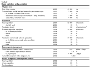 Table 1. Basic statistics and population. (Source: FAO)
 The climate is wet tropical (equatorial) with little variation in temperature (27°C) and relative humidity (80 percent) during the year. The climate is dominated by patterns of monsoons. The southeast monsoon, from May to October, brings in cool winds but little rainfall. This is the main vegetable growing season. The northwest monsoon, from November to April, brings variably gentle winds with low clouds and heavy rainfalls. It is a difficult season for vegetable production, due to high temperatures and rainfall and torrential rainstorms. Average annual precipitation is 2,330 millimeters (mm), varying from 2,370 mm on Mahe Island, to 1,990 mm on Praslin Island, 1,620 mm on La Digue Island, and 1,290 mm on average on the other islands. The heaviest rains occur on Mahe Island where the central plateau with an altitude of 900 m above sea level receives up to 3,500 mm/year, while the south of the island receives less than 1,800 mm/year.
Total population of the country is 82,000 inhabitants (2004), of which 50 percent are rural. Annual population growth rate is 1 percent (1990-2002). The population density is 182 inhabitants/km2, but varies from 1 inhabitant/km2 on the coralline islands to more than 159 inhabitants/km2 on La Digue Island and Praslin Island and 446 inhabitants/km2 on Mahe Island. The unemployment rate is 7 percent.
Economy Agriculture and Food Security
In 2003 the Gross Domestic Product (GDP) was US$720 million (current US$), of which agriculture accounted for 3.3 percent. About 30,000 people, or 77 percent of the economically active population, are active in agriculture (Table 1). Agricultural production output statistics in 2002 showed that 100 percent of the eggs, 80 percent of the poultry, 60-65 percent of the fruits and vegetable as well as the pork consumed were produced locally. Domestic export consists mainly of canned tuna, which contributed to 86 percent of the total export. There is a continuous decline in the exportation of raw products, especially copra and cinnamon, which in the 1970s occupied 95 percent of the total export and employed up to 70 percent of the population. The agricultural sector is characterized by small family farms practicing mixed farming.
Water Resources and Use
Water Resources
The granitic islands have many small, steep watercourses, but most of them have only ephemeral flows. Groundwater resources are limited as not much water is stored at the feet of the hills and the water available is often hard and contains traces of salt. The wetlands have recently become an attraction for eco-tourism given their rich biodiversity. The total dam capacity is 0.970 million cubic meters (m3). The Rochon Dam, which collects its waters from the Rochon River, has a storage capacity of 0.050 million m3. Surplus water is forwarded to the La Gogue Dam, which has a storage capacity of 0.920 million m3.
In 2003, 8.8 million m3 of wastewater were produced. Wastewater is treated at the central sewerage treatment plant in Victoria and Beau Vallon with an annual production of 0.9 million m3/year (Table 2). The remainder is being disposed of via septic tanks. Industry reuses about 0.006 million m3/year of the treated wastewater. About 1.0 million m3/year of desalinated water is produced for potable use to compensate for the shortage that occurs during the dry period. There are four desalination plants, two on Mahe Island, one on Praslin Island, and one on La Digue Island.
|
Table 2. Water:sources and use Renewable water resources Avergage precipitation 2,330 mm/yr 1,049 109 m3/yr Internal renewable water resources 109 m3/yr Total actual renewable water resources 109 m3/yr Dependency ratio 0 % Total actual renewable water resources per inhabitant m3/yr Total dam capacity 1989 0.97 106 m3 Water withdrawal Total water withdrawal 2003 12.3 106 m3/yr - irrigation + livestock 2003 0.9 106 m3/yr -domestic 2003 8.0 106 m3/yr -industry 2003 3.4 106 m3/yr -per inhabitant 2003 152 m3 -as% of total actual renewable water resources - % Non-conventional sources of water Produced wastewater 2003 8.8 106 m3/yr Treated wastewater 2003 0.9 106 m3/yr Reused treated wastewater 2003 0.006 106 m3/yr Desalinated wastewater 2003 1.0 106 m3/yr Reused agricultural drainage water 106 m3/yr (Water profile of Seychelles) Water Use
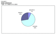 Figure 1. Water withdrawal in the Seychelles. (Source: FAO) Figure 1. Water withdrawal in the Seychelles. (Source: FAO) In 2003 total water withdrawal was 12.3 million m3, of which agriculture accounted for only 7 percent (Table 2 and Figure 1). Most of the agricultural, domestic, and industrial waters come from small streams or rivers from the hillsides, depending on monsoons and the rainfall pattern. The abstraction of surface water amounts to around 11.2 million m3/year (2003) and of groundwater to 0.3 million m3/year (2003.) The principal groundwater abstraction is on la Digue Island for domestic and agricultural consumption. Irrigation and Drainage DevelopmentEvolution of Irrigation Development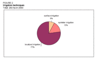 Figure 2. Irrigation techniques. (Source: FAO) Figure 2. Irrigation techniques. (Source: FAO) The irrigation potential in Seychelles is estimated at 1,000 ha. Both irrigation and drainage have taken a tremendous step forward in the last 30 years, from small-scale gardening watered by watering cans to localized and sprinkler irrigation. Two state farms introduced drip irrigation on an experimental basis, which failed due to lack of know-how and exigencies of the operation and maintenance of the overall set-up. Later research focused basically on localized irrigation and results were disseminated to farmers and gradually there was a re-introduction of micro-sprinkler and drip irrigation. 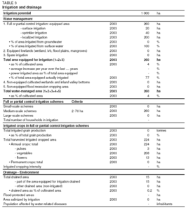 Table 3. Irrigation and drainage. (Source: FAO) Table 3. Irrigation and drainage. (Source: FAO) The total area equipped for full/partial control irrigation is 260 ha (2003), of which surface irrigation is 20 ha, sprinkler irrigation 40 ha, and localized (drip) irrigation 200 ha (Table 3 and Figure 2). 77 percent of the area equipped for irrigation is actually irrigated. Surface water is used for irrigation. Only during very dry conditions, when surface water starts to dry out, will farmers living at sea level pump groundwater and mix it with surface water to be able to meet the crop water requirements. All irrigation schemes are medium-scale schemes (2-70 ha) and state-owned. Role of Irrigation in Agricultural Production, the Economy, and SocietyThe harvested, irrigated, and cropped total consists of vegetables (208 ha), pulses, (3 ha) and flowers (13 ha) (Table 3 and Figure 3). The main irrigated vegetables and pulses are cabbage, pumpkin, beans, tomatoes, eggplant, cucumber, lettuce, spring onion, cocoyam, capsicum, okra, and spices. Crops such as sweet potatoes, cassava, plantains, sugar cane, bananas, and citrus fruits are rainfed but irrigated at the planting stage. The development cost of public surface irrigation schemes is on average US$2,437/ha, and operation and maintenance cost US$500/ha per year. On-farm installation for sprinkler irrigation is around US$6,000/ha and for localized irrigation US$8 000/ha. Operation and maintenance is carried out by a group of workers under the Irrigation Unit of the Ministry of Agriculture and Marine Resources. Water supply to the schemes is metered and farmers are billed monthly by the Irrigation Unit for their consumption. Water is distributed according to farm activity and size. Men and women have the same role on the farm. Status and Evolution of Drainage Systems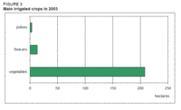 Figure 3. Main irrigated crops in 2003. (Source: FAO) Figure 3. Main irrigated crops in 2003. (Source: FAO) Drainage is important in the lowland areas, which experience temporary but high accumulations of water during heavy and intense rainfall. The total irrigated area under drainage is 15 ha. Rainfed areas are not drained. The main drains are constructed by digging and opening the waterway in the natural drainage system to evacuate water during heavy rains. Farmers are responsible for creating secondary and possibly tertiary drains themselves. Water Management, Policies, and Legislation Related to Water Use in AgricultureInstitutionsMain institutions involved in the irrigation and water sub-sectors:
FinancesFunding for water development activities is determined by the government. The MAMR is responsible for planning and procurement. The Irrigation Unit under the Public Utilities Corporation invoices the farmers on a monthly basis for their water consumption. The tariff is US$0.30/m3 for the first 150 m3 and above that US$0.20/m3. Policies and LegislationThe most important water act is the Public Utilities Corporation Act 1985, which empowers the Rivers Committee to manage all water resources and allows it to prepare project plans for water development in the country. However, the water policy of the country puts more emphasis on the collection of water for domestic purposes. Environment and HealthFarmers in the lowland [[coast]al] areas have drainage systems installed. No areas are waterlogged or salinized. Generally, water destined for agricultural use is clean and can also be used for household purposes and drinking if boiled. Perspectives for Agricultural Water ManagementIn its 2000-2010 mission statement, the MAMR proposed the development of more agricultural areas to be equipped with the basic requirements for farming whereby roads and water are top priorities. However, the role of the government for irrigation services is uncertain. More freshwater could be made available on the northern part of Mahe Island, where there is potential for development of another dam. The government is also investigating the possibility for a water development project in the Grand Anse catchment area in the central-west part of Mahe Island. Further Reading
| ||||