Water profile of Ethiopia
Contents
- 1 Geography, Climate, and Population
- 2 Economy, Agriculture, and Food Security
- 3 Water Resources and Use
- 4 Irrigation and Drainage Development
- 5 Water management, Policies, and Legislation Related to Water Use in Agriculture
- 6 Environment and Health
- 7 Perspectives for Agricultural Water Management
- 8 Further Reading
Geography, Climate, and Population
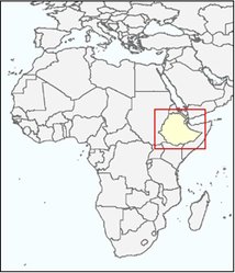 Map of Ethiopia. (Source: FAO)
 Ethiopia, with a total area of 1.1 million square kilometers (km2), lies in the northeastern part of the Horn of Africa. The country is landlocked, sharing frontiers with Eritrea to the north and northeast, Djibouti to the east, Somalia to the east and southeast, Kenya to the south, and Sudan to the west. Ethiopia’s topographical diversity encompasses high and rugged mountains, flat-topped plateaus, and deep gorges with rivers and rolling plains with altitudes ranging from 110 meters (m) below sea level at the Denakil Depression in the northeast to over 4,600 m above sea level in the Simien Mountains in the north. There are diverse soil types in the country. Combisols are predominant over much of the highlands, while vertisols occur in large areas of the southeastern highlands and in the southwestern parts of the country. Regosols occupy much of the Somali plateau and the northeastern part of the country.
Ethiopia has a tropical monsoon climate with wide topographic-induced variation. Three climatic zones can be distinguished: a cool zone consisting of the central parts of the western and eastern section of the high plateaus, a temperate zone between 1,500 m and 2,400 m above sea level, and the hot lowlands below 1,500 m. Mean annual temperature varies from less than 7-12ºC in the cool zone to over 25ºC in the hot lowlands. Mean annual potential evapotranspiration varies between 1,700-2,600 millimeters (mm) in arid and semi-arid areas and 1,600-2,100 mm in dry sub-humid areas. Average annual rainfall for the country is 848 mm, varying from about 2,000 mm over some pocket areas in southwest Ethiopia to less than 100 mm over the Afar Lowlands in the northeast. Rainfall in Ethiopia is highly erratic, and most rain falls intensively, often as convective storms, with very high rainfall intensity and extreme spatial and temporal variability. The result is that there is a very high risk of annual droughts and intra-seasonal dry spells. Considering the water balance and the length of the growing period, Ethiopia can be divided into three major agroclimatic zones:
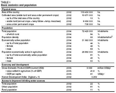 Table 1: Basic statistics and population. (Source: FAO)
 - Areas without a significant growing period, with little or no [[(eastern, northeastern, southeastern, southern, and northern lowlands) *Areas with a single growing period and one rainy season from February/March to October/November, covering the western half of the country, with the duration of the wet period decreasing from south to north *Areas with a double growing period and two rainy seasons (Belg and Meher) which are of two types: bimodal type 1 and bimodal type 2. The region of type 1 in the east of the country has a small rainfall peak in April and a major one in August. The region of type 2, covering most of the lowlands of the south and southeast, has two distinct wet periods, February-April and June-September, interrupted by two clear-cut dry periods. The peak rainfall months are April and September. The country’s total population] is 72.4 million (2004), of which about 84% is rural (Table 1). The annual population growth rate is about 2.3%. Population density is 66 inhabitants/km2, but varies from 7 inhabitants/km2 in Afar in the northeast to 114 inhabitants/km2 in Southern Region in the southwest of the country. The urban population is growing rapidly as a result of both natural increase and high rural-urban migration. This is putting more and more strain on urban services and employment. The unemployment rate is 2.9% and under-employment is common, particularly in rural areas. In 2000, 44% of the population lived below the national poverty line. Only about 22% of the population had access to improved drinking water sources in 2002, going from 81% in the urban areas down to only 11% in the rural areas (Table 1). Sanitation coverage is only 6%, going from 19% of the urban population to 4% of the rural population. The infant mortality rate was 114 per 1,000 life births in 2002 and the under-5 mortality rate was 171 per 1,000 children.
Economy, Agriculture, and Food Security
The country’s Gross Domestic Product (GDP) (current US$) was US$6.6 billion in 2003 with an annual growth rate of 2.7%. In the same year, agriculture accounted for almost 42% of GDP and about 85% of exports. Coffee is the largest export commodity for Ethiopia, drawing in 60-70% of foreign exchange earnings. The value of imports is usually considerably higher than the value of exports. In 2001, food imports and exports were about 26,283 MT (US$193.7) and 1,584 MT (US$138.7 million) respectively.
About 81% of the economically active population works in agriculture. The cultivated area covered about 10.7 million hectares (ha) in 2002, of which 10 million ha arable land and 0.7 million ha permanent crops (Table 1). In 1999, 83% of rural households cultivated less than 2 ha per household and 52% less than 1 ha. The following five main agricultural production systems can be distinguished in the country:
- The highland mixed farming system is characterized by a very low level of specialization of production based on environmental and land suitability and is practiced by about 80% of the country’s population on about 45% of the total land mass in areas at more than 1,500 m above sea level. Livestock production is an integral part of the system, but is increasingly being restricted to stall feeding of animals due to scarcity of land. Animal traction (oxen) is used for land preparation to produce mainly cereals, pulses, and oil crops. The highland mixed farming system includes the grain plow complex and the horticulture hoe complex. The grain plow complex is practiced in the barley and wheat producing areas of the eastern mountains and the predominantly teff growing regions of the central and northern highlands. Declining landholding sizes because of population growth and deteriorating soil fertility are among the biggest challenges facing this production system. The horticulture hoe complex is based on the use of hoes and animal drawn plows for the production of crops that include domesticated enset, coffee, khat, and other horticultural crops and maize. Most regions of the south and southwest with prolonged humid periods practice this system.
- The lowland mixed agricultural production system is practiced in low-lying plains, valleys, and mountain foothills, which include the northern parts of the Awash and the rift valley with elevations of less than 1,500 m. These areas mainly produce drought-tolerant varieties of maize, sorghum, wheat, and teff, along with some oil crops and lowland pulses. Oxen are used for providing traction power and communal grazing lands and crop residues are used for livestock rearing. Off-farm activities such as sale of firewood and charcoal are widely practiced.
- The pastoral complex supports the livelihood of only 10% of the total population living in the Afar and Somali regions and the Borena zone. Livestock is the major livelihood basis of these populations that are highly mobile in search of water and grazing. Camels are the most important animals serving as both food and means of transport. Some lowland varieties of maize, sorghum and other cereals are also cultivated on flood plains or as rainfed crops.
- Shifting cultivation is practiced in the southern and western part of the country. Fields are usually left idle after short periods of cultivation to revegetate (usually 1-2 years). Clearing of the vegetation cover is done by setting fire to it during the dry seasons before the planting of sorghum, millet, sesame, cotton, and ginger. These areas have low population densities and in some of them, livestock production is constrained by tsetse fly infestation.
- Commercial agriculture is a farming system that has only emerged very recently. However, access to land and infrastructure-related problems as well as investment insecurity are major hindrances to the growth of this system of production.
Food insecurity, as a result of persistent drought among other reasons, has been the order of the day for a very long period in Ethiopia. Even during good years, the survival of some 4-6 million people depends on international food assistance. HIV/AIDS poses the foremost threat to poverty reduction and is a major source of vulnerability. In 2001, 6.6% of adults were estimated to be infected, with 3.7% in rural areas, 13.7% in urban areas and 15.6% in the capital Addis Ababa. The highest prevalence of HIV is seen in the group of 15-49 year-olds. This age group is the most economically productive segment of the population, thus indicating the negative impact of the epidemic on labor productivity.
Water Resources and Use
Water Resources
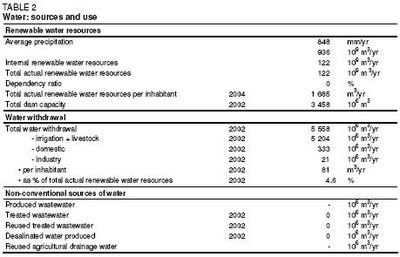 Table 2: Water: Sources and use. (Source: FAO)
 Ethiopia is endowed with a substantial amount of water resources. The surface water resource potential is impressive, but little developed. The country possesses twelve major river basins, which form four major drainage systems:
- The Nile basin (including Abbay or Blue Nile, Baro-Akobo, Setit-Tekeze/Atbara, and Mereb) covers 33% of the country and drains the northern and central parts westwards
- The Rift Valley (including Awash, Denakil, Omo-Gibe, and Central Lakes) covers 28% of the country
- The Shebelli-Juba basin (including Wabi-Shebelle and Genale-Dawa) covers 33% of the country and drains the southeastern mountains towards Somalia and the Indian Ocean
- The North-East Coast (including the Ogaden and Gulf of Aden basins) covers 6% of the country
Integrated development master plan studies and related river basin surveys undertaken at the end of the 1990s indicate that the aggregate annual runoff from nine Ethiopian river basins is about 122 km3 (Table 2). The Abbay, Baro-Akobo, and Omo-Gibe basins account for about 76% of the total runoff from an area that is only 32% of the total area of the country (Table 3). Most of the rivers in Ethiopia are seasonal and about 70% of the total runoff is obtained during the period June-August. Dry season flow originates from springs which provide baseflows for small-scale irrigation. The groundwater potential of the country is not known with any certainty, but so far only a small fraction of the groundwater has been developed and this mainly for local water supply purposes. Traditional wells are widely used by nomads. Neither desalinization nor treatment of wastewater is practiced in Ethiopia.
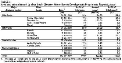 Table 3: Area and annual runoff by river basin. (Source: FAO)
 Intense rainfall sometimes causes flooding particularly along the Awash river and in the lower Baro-Akobo and Wabe-Shebelle river basins, causing damage to standing crops and infrastructures. The construction of dikes mitigated the problem but has not provided a long-lasting solution. Ethiopia has several lakes (an area of about 7,000 km2), a number of saline and crater lakes as well as several wetland areas. All the lakes, except Lake Tana which is the source of Abbay River in the Nile Basin, are found in the Rift Valley and among these lakes only Zway has fresh water while the others are all saline. Rising water levels in Lake Tana and Lake Awassa after intense rainfall have been creating concern. Large wetlands serve as a source of water for major rivers, flood retention and groundwater recharge. They are critical resources because they are areas of high biodiversity and are often vital to the livelihood strategies of local communities through the provision of environmental services and socio-economic benefits. Ethiopia has so far put no emphasis on developing and protecting the large wetlands, although external initiatives are emerging.
Ethiopia has many small, medium, and large reservoir dams constructed for hydropower generation, irrigation, and drinking water supply. Small dams are less than 15 m high and have a capacity of less than 3 million m3. The height of the medium and large dams in Ethiopia is 15-50 m and their capacity ranges from 4 to 1,900 million m3. In total, there are nine medium and large dams with a total capacity of almost 3.5 km3. Two large dams are used for hydropower generation only, one dam is used both for hydropower generation and irrigation supply, two dams are used for irrigation supply only and the remaining four for water supply to the city of Addis Ababa and the town of Gondar. Small dams (micro-dams) constructed for irrigation supply are concentrated in the Amhara and Tigray regional states.
Water Use
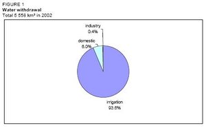 Figure 1: Water withdrawal. (Source: FAO)
 Written information on water use is not available, but agriculture is obviously the main water-consuming sector. Based on the total irrigated area, cropping pattern and calendar, annual agricultural water use is estimated to be in the order of 5.2 km3, while domestic and industrial water withdrawals are estimated to be about 0.33 and 0.02 km3 respectively (Table 2 and Figure 1). There is growing concern about water use because of the conflict between the environment and agriculture particularly in lowland rural areas, where total baseflows are diverted for irrigation without releasing water for ecological conservation. Groundwater has not yet been considered for irrigation development, mainly due to high investment and running costs, but pilot schemes to use groundwater for irrigation have been started.
International Water Issues
Most of the rivers of Ethiopia originate within the country and flow across the borders to neighboring countries, thus becoming transboundary rivers. Sharing the water resources of these transboundary rivers is very challenging, particularly the Nile tributaries (Abbay, Tekeze, and Baro-Akobo) with the downstream riparian countries Sudan and Egypt. Recently, under an international law supporting the equitable utilization of the water resources, positive progress has been observed now that riparian countries are deciding on common water development programs. The Nile Basin Initiative has been created and a Strategic Action Program prepared which consists of two sub-programs: the Shared Vision Program (SVP) and the Subsidiary Action Program (SAP). SVP is to help create an enabling environment for action on the ground through building trust and skill, while SAP is aimed at the delivery of actual development projects involving two or more countries. Projects are selected by individual riparian countries for implementation and submitted to the Council of Ministers of the Nile Basin Initiative for approval. The council has already accepted four hydropower and four irrigation development projects proposed by Ethiopia. Sudan, Ethiopia, and Egypt have also adopted a strategy of cooperation in which all projects to be launched concerning the river should seek the common benefit of all member states and this aspect should be included in the accompanying feasibility studies.
Irrigation and Drainage Development
Evolution of Irrigation Development
River basin master plan studies and related surveys indicate a maximum irrigation potential of about 5.7 million ha, but about 3.6 million ha is commonly quoted. The irrigation potential of Ethiopia is at present estimated at about 2.7 million ha, considering the availability of water and land resources, technology, and finance (Table 4).
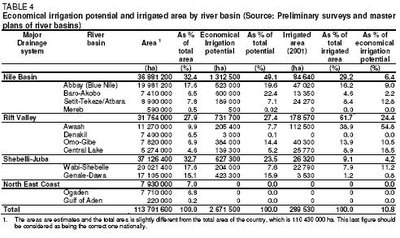 Table 4: Economical irrigation potential and irrigated area by river basin. (Source: FAO)
 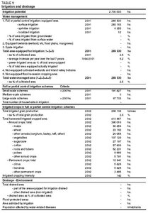 Table 5: Irrigation and drainage. (Source: FAO)
 Irrigation in Ethiopia dates back several centuries, if not millennia, while "modern" irrigation was started by the commercial irrigated sugar estate established in the early 1950s by the Imperial Government of Ethiopia and the Dutch company known as HVA-Ethiopia. Various sources give different estimates of irrigated area, but recent sources indicate that the area equipped for irrigation was nearly 290,000 ha in 2001, which is 11% of the economical irrigation potential of 2.7 million ha (Table 5). The actually irrigated area has not been estimated but field assessments in small-scale irrigation projects indicate that some irrigation schemes are not operating to their full potential and some are not functional at all due to factors related to shortage of water, damaged structures, and poor water management. On the other hand, farmers are extending canal networks in some modern irrigation projects and can therefore irrigate more land than is reportedly equipped for irrigation. Therefore, the area under irrigation can be considered more or less similar to the area equipped for irrigation.
Four categories of irrigation schemes can be distinguished (Table 6 and Figure 2):
- Traditional irrigation schemes: These schemes are constructed under self-help programs carried out by farmers on their own initiative and vary from less than 1 ha to 100 ha. The total irrigated area is estimated to be about 138,000 ha and about 572,000 farmers are involved. Traditional water committees, locally known as ‘water fathers’, administer the water distribution and coordinate the maintenance activities of the schemes. Traditional irrigation is also very common in peri-urban areas, particularly in Addis Ababa and Bahir Dar, for the production of vegetables for the local market. The major drawback of traditional irrigation schemes is related to unstable headworks and faulty systems of irrigation stemming from lack of technology and knowledge.
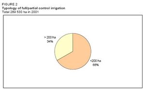 Figure 2: Typology of full/partial control irrigation. (Source: FAO)
 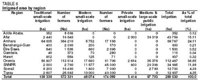 Table 6: Irrigated area by region. (Source: FAO)
 - Modern small-scale irrigation schemes: These schemes use technologies for irrigating up to 200 ha and are constructed by the government/NGOs with farmer participation. They are generally based on direct river diversions but they may also involve micro-dams for storage. The area equipped for irrigation in 2002 was about 48,300 ha and about 74,100 farmers were involved. The operation and maintenance of the schemes are the responsibility of the water users, supported by the regional authorities/bureaus in charge of irrigation development and management. Water Users Associations (WUAs) are formally established in some schemes but traditional water management dominates in most of the modern schemes.
- Modern private irrigation: Private investment in irrigation has recently re-emerged with the adoption of a market-based economy policy in the early 1980s. Virtually all irrigated state farms were privately owned farms until nationalization of the private property in the mid 1970s. At the end of 2000, private investors had developed about 5,500 ha of irrigated farms, distributed in Afar (37%), Oromia, and the Southern Nations, Nationalities and People’s Region (SNNPR) also known as the Southern Region (15%).
- Public irrigation schemes: These schemes comprise medium- and large-scale irrigation schemes with areas of 200-3,000 ha and above 3,000 ha respectively and a total estimated area of about 97,700 ha. They are constructed, owned and operated by public enterprises. These schemes are concentrated along the Awash River Course and were constructed in the 1960s-70s as either private farms or joint ventures. No such schemes have been developed for the last 7-8 years.
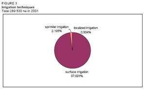 Figure 3: Irrigation techniques. (Source: FAO)
 About 62% of the area equipped for irrigation is located in the Rift Valley, while 29% of the area equipped for irrigation is located in the Nile basin. The remaining 9% is located in the Shebelli-Juba basin (Table 4). Region-wise, about 39% of the irrigated area is in Oromia in central Ethiopia, followed by 24% in Amhara in the north, 15% in Afar in the northeast and 12% in SNNPR, while the remaining 10% is in the other regions (Table 6). Nearly 100% of the irrigated land is supplied from surface water, while groundwater use has just been started on a pilot scale in East Amhara. Sprinkler irrigation is practiced on about 2% of the irrigated area for sugar cane production by government enterprises, while localized irrigation has recently started in the Tigray and Amhara regions (Figure 3). Pump irrigation by a group of farm households and private farms is practiced in some areas, while human-powered (treadle pump) irrigation has also recently started in the Tigray and Amhara regions. Though quantitative information is not available, spate irrigation and flood recession cropping are practiced in the lowland areas of the country, particularly in Dire Dawa, Somali, East Amhara, and Tigray in the eastern and northeastern parts of the country.
Role of Irrigation in Agricultural Production, Economy, and Society
 Figure 4: Irrigated crops. (Source: FAO)
 Both irrigated and rainfed agriculture is important in the Ethiopian economy. Virtually all food crops in Ethiopia come from rainfed agriculture with the irrigation sub-sector accounting for only about 3% of the food crops. Export crops such as coffee, oilseed, and pulses are also mostly rainfed, but industrial crops such as sugar cane, cotton, and fruit are irrigated. Other important irrigated crops include vegetables and fruit trees in medium- and large-scale schemes and maize, wheat, vegetables, potatoes, sweet potatoes, and bananas in small-scale schemes (Table 5 and Figure 4). There is a marked value added in irrigated agriculture. A case study carried out in 2001 estimated that average yields of cereals under irrigation and rainfed conditions are 1.75 and 1.15 tons/ha respectively. The same study indicated that production costs per ha were US$90 for cereals, US$60 for pulses and US$290 for vegetables, while the corresponding gross incomes per ha were US$345, US$215, and US$1,870.
Development costs per hectare of small-scale irrigation schemes are US$1,760-2,940 for direct river diversion schemes and US$4,700-7,100 for schemes requiring micro-dams, while the respective annual operation and maintenance (O&M) costs per hectare are US$70-120 and US$160-240 respectively. In 1998, development costs for public surface irrigation schemes (large- and medium-scale) were estimated to be in the range of US$3,300-12,800/ha, with the average cost being US$8,100/ha. This high cost is due to the fact that the construction of expensive headworks is included in the calculation. Annual O&M costs for these schemes are US$60-220/ha. The cost of sprinkler and localized irrigation installation is about US$5,160/ha and US$5,560/ha respectively.
The proportion of traditionally irrigated land (almost half of the total irrigated area) and the number of farmers involved indicate the significant economic and social role of traditional irrigation for rural society. Urban and peri-urban irrigation are not significant in terms of area coverage and production, but the traditional irrigation practice around Addis Ababa plays an important role in supplying vegetables for the Addis Ababa market.
Supplementary irrigation is widely practiced in all irrigation categories, although separate quantitative information on the area supplied with supplementary irrigation is not available. The areas under traditional and small-scale irrigation systems are supplied with full irrigation during dry periods and with supplementary irrigation when the rain comes late or withdraws early, or when there is inadequate rainfall.
Rainfed farming has always been the main livelihood for most Ethiopian people and it is supported by traditional water harvesting practices particularly in central-north, eastern, and southeastern areas of the country.
Status and Evolution of Drainage Systems
Drainage is as important as irrigation, particularly in the highlands of Ethiopia. However, except in irrigated lands, drainage is not given the required attention in rainfed agriculture where farmers construct traditional drain ditches commonly diagonal to the main slope of the farmlands. Because of irregularity in cross-sections and longitudinal slopes as well as inadequate capacities, the drains are usually converted to gullies if the same drains are adopted year after year. To avoid this happening, drain lines are changed every year. Designs of small-scale irrigation schemes incorporate drainage systems but these are not properly implemented. The typology of the drainage system used in the country is the surface drainage system (gravity drainage). The construction of subsurface drainage systems was started for one large-scale irrigation scheme in the Awash Valley for salinity control, but was discontinued. Separate information on the cost of drainage systems is not available because it is included in the overall development cost of the irrigation system.
Water management, Policies, and Legislation Related to Water Use in Agriculture
Institutions
Several water sector institutions have been established at federal and regional levels under the regionalization and decentralization of policy.
At the federal level, the public institutions involved in water resources development include:
- The Ministry of Water Resources (MoWR) is responsible for the overall planning, development, management, utilization, and protection of the country’s water resources, as well as supervising all water development activities carried out by other institutions. Large-scale water supply is also handled by the ministry through its Water Supply and Sewerage Department.
- The Awash Basin Water Resources Management Agency (ABWRMA) is the only basin level institution established for administering and managing the Awash River Water. Most of the medium- and large-scale irrigation projects and salinity and flooding problems are concentrated in this basin.
- The Ministry of Agriculture (MoA) is in charge of water management (irrigation extension), including water harvesting for smallholder irrigated and rainfed agriculture.
- The Environmental Protection Authority (EPA) is responsible for the preparation of environmental protection policy, laws, and directives. It is also in charge of evaluating the impact of social and economic development projects, particularly irrigation and hydropower projects, on the environment and is further responsible for follow-up work.
The regional/sub-national institutions involved in the water sector include:
- The Bureaus of Water, Mines and Energy (BoWME) and/or Bureaus of Water Resources Development (BoWRD) which exist in some regions and are responsible for small-scale irrigation and rural water supply as well as small-scale hydropower development
- The Commissions for Sustainable Agriculture and Environmental Rehabilitation (Co-SAER) and the Irrigation Development Authorities which undertake operational activities in line with their mandates (study, design, and construction of small-scale irrigation schemes).
- The Bureaus of Agriculture (BoA) have similar functions at the regional scale as the MoA.
- Several NGOs are involved in the water sector, particularly in small-scale irrigation and rural water supply projects.
Water Management
Medium and large-scale irrigation schemes are managed by government enterprises. The water management of small-scale irrigation schemes is the responsibility of the farmers themselves, mainly through informal/traditional community groups. Some formal Water Users Associations (WUAs) have been established. Apart from the provision of extension and training services to the WUAs on the part of the MoA/BoA, no institution is directly involved in water management in smallholder-irrigated agriculture. Once the construction of irrigation schemes is completed, they are handed over to the beneficiaries but maintenance remains within the responsibility of the regional governments. The absence of any appropriate local-level organs to cater for small-scale irrigation has resulted in a lack of guidance in irrigation operation and maintenance at a community level. With an increase in irrigated areas and more users, irrigation water management and rules for water allocation are becoming more complex and problematic. Disputes are already common, especially between upstream and downstream users. A decentralization process is under way with regional and lower level administrative organs which are becoming more autonomous in aspects related to irrigation development and water management. The strategy is to establish WUAs before projects are implemented and to strengthen them through both training and involvement in the process so that they can take over the responsibility of operation and water management when construction is completed.
Finances
Funding for water development activities is determined by the federal or regional government. The irrigation authorities have financial autonomy only over their approved and allocated budget. So far, neither cost recovery nor irrigation charges have been considered in irrigation development. However, in some cases beneficiaries have been contributing to the development of some small-scale irrigation schemes by providing free labor for up to 10% of the investment. The 15-year National Water Sector Development Program, presented in 2002, envisages cost recovery or cost-sharing mechanisms, in which case financing for small-scale irrigation development projects will come from the regional governments (45%), beneficiaries (20%), multilateral and bilateral sources (20%), NGOs (10%), and private investors (5%). Similarly, medium- and large-scale irrigation development will be covered by the federal government (40%), multilateral and bilateral sources (40%), beneficiaries (10%), and private investments (10%). Obviously, there is a long way to go to establish a cost-sharing system because most beneficiaries have not even contributed to the operation and management of the existing schemes let alone to construction costs. In some small-scale irrigation schemes, though, beneficiary communities collect irrigation charges for covering minor maintenance costs, each beneficiary paying the same amount irrespective of farm size or quantity of water consumed.
A Water Resources Development Fund (WRDF) has been established recently within the MoWR to serve as a public financial intermediary dedicated to financing the water supply and sanitation services and irrigation development through the provision of a long-term loan to groups meeting established criteria and based on the principles of cost recovery. The WRDF, which finds funds from donors, is a nucleus for the development of a financially autonomous institution for water resources development through a cost recovery system.
Policies and Legislation
A comprehensive and integrated Water Resources Management Policy, prepared by the MoWR, was adopted in 2000. Some of the guiding principles are: i) recognition of water as a scarce and vital socio-economic resource to be managed and planned strategically; ii) recognition of water as an economic good; iii) stakeholders to be involved in water resources management. Relevant proclamations include:
- Proclamation No. 197/2000, stating that all of the country’s water resources are the common property of the Ethiopian people and the state and giving the MoWR the necessary power to allocate and apportion water to all regional states regardless of the source and location of the resource.
- Proclamation No. 4/1995, stating that the MoWR has the power and duty to determine the conditions and methods required for the optimum allocation and utilization of the water that flows across or between more than one regional government among various users.
- Proclamation No. 41/1993, granting the regions the mandate for certain aspects of water resource management, including small-scale hydropower activities.
- Proclamation No. 197/1992, dealing with the water resources management regulations describing development areas that require a license, procedures for obtaining licenses, the allocation of water for various uses and the need to protect water resources from pollution. It considers that water is an economic good and that it has to be valued and deserves protection. A water code is being drafted.
The overall objective of the Irrigation Policy, which is one chapter of the Water Resources Management Policy, is to develop the huge irrigated-agriculture potential for the production of the food crops and raw materials needed for agro-industries in a sustainable way. The policy emphasizes:
- Full integration of irrigation with the overall framework of socio-economic development plans, and more particularly with the Agricultural Development Led Industrialization Strategy,
- Irrigation being an integral part of the water sector and overall water resources development
- A reasonable percentage of the GDP being committed to the development of irrigation
- Decentralization and user-based management of irrigation systems, considering the special needs of rural women
- Developing priority schemes based on food requirements and the national economy
- Supporting and enhancing traditional irrigation schemes
- Ensuring the prevention and mitigation of the degradation of irrigation water
- Establishing water allocation and priority setting criteria
- Integration of appropriate drainage facilities and environmental sustainability requirements
- Enhancing greater participation of regional and other stakeholders
- Promoting fairness and transparency in the management of irrigated agriculture
Water Resource Sector Strategies have been developed and short-, medium-, and long-term Sector Development Programs prepared for the period 2002-2016. These strategies include the financing of water resources management and development; the creation of an enabling environment; transboundary rivers management; stakeholder participation and gender mainstreaming; disaster-prevention and public safety, and environmental health standards.
Environment and Health
No irrigated land has reportedly been abandoned due to salinity so far, but salinity problems are being observed in irrigated lands along the Awash River. In addition, water pollution in the Awash River is becoming a concern. Generally, however, the water quality is within the suitable range of irrigation water quality standards. The problem of water quality due to drainage water from irrigated fields is not serious because the large rivers dilute it. In small-scale irrigation schemes, particularly in lowland areas, hardly any drainage water goes into the rivers. However, industrial effluents are being emptied directly into the river system and its tributaries in an uncontrolled manner. A major problem in the country is soil erosion and land degradation, resulting in the sedimentation of reservoirs and the high cost of allowing for silt accumulation in the reservoirs. Studies indicate that annual soil erosion in Ethiopia varies from 17 to 300 tons/ha.
Although the extent is not known, water-related diseases and malaria are prevalent in irrigated areas not only in medium- and large-scale but also in small-scale irrigation schemes because canal water is being used for domestic purposes.
Perspectives for Agricultural Water Management
Even in good years Ethiopia cannot meet its large food deficit through rainfed production. Growing population pressure in the highland areas of rainfed agriculture on a rapidly declining natural resource base has secured irrigated agriculture a prominent position on the country’s development agenda. Ethiopia plans to develop an additional 274,612 ha of irrigated land (127,138 ha small-scale and 147,474 ha medium- and large-scale) up to 2016. However, while human, land, and water resources for irrigation development may be available, constraints are the lack of institutional capacity, private sector involvement, and markets, as well as food insecurity which affects the dilemma of cost recovery because of targeting food security first by growing food crops instead of cash crops.
Based on the seasonal irrigation water requirements of each crop and improved irrigation efficiency (45%), annual agricultural water use is expected to increase from the present estimated demand of about 5.2 to 9.0 km3 in 2016. Farmers in southern Ethiopia used to produce cotton under irrigation but bananas, papayas, and vegetables are now preferred as a result of the unattractively low prices of cotton. Similarly, teff, which is the staple food for a significant proportion of Ethiopians and which has a low water demand, is presently grown under irrigation, but because of its low productivity and high labor demand it may be replaced by another crop. Hence, cropping patterns will have an impact on agricultural water demand. During years of drought, crops with high water demand may be discouraged in order to safeguard hydropower generation.
So far, irrigation development has been based on a single project approach and hence it has had both positive and negative social and environmental impacts. The Water Resources Management Policy emphasizes an integrated approach to water resources development to maximize the positive impact and avoid or minimize any negative effects of irrigation development. Under this policy, the following departments/units have been established within the MoWR: The Irrigation and Drainage Department; The Dams and Hydropower Department; The Policy Development Coordination and Foreign Relations Department; The Water Utilization Control Function Section within The Master Plan Development Studies Department; The Research and Development Department; and The Water Resources Development Fund (WRDF).
Further Reading
- Water profile of Ethiopia, Food and Agriculture Organization.
- World Factbook: Ethiopia, Central Intelligence Agency.
- Annen, Chris T. 2001. Promotion of Small-Scale Irrigation in Food Insecure Woredas of Ethiopia. Document submitted to the IDA, World Bank.
- Aytenffisu, M. 1981. Groundwater in Ethiopia.
- Central Statistical Authority of Ethiopia. 2000/01. Agricultural sample survey, Report on Farm Management Practices of Belg Season Crops.
- FAO. 1990. Irrigation policy and strategy in Ethiopia. Report of FAO Technical Cooperation Project TCP/ETH/8963.
- FAO. 1994a. Studies for integrated irrigation systems - Ethiopia - Project findings and recommendations. Terminal Report of UNDP/FAO project ETH/88/001.
- FAO. 1994b. Ethiopia: Small-scale irrigation consolidation project, Preparation report. FAO/DDC Report 59/94 ADB-ETH 48.
- Ministry of Agriculture. 2001. The Development of Irrigation Agriculture in the Baro-Akob, Awash, Abbay, Omo-Ghibe River Basins. September 2001.
- Ministry of Health, Disease Prevention and Control Department. 2002. AIDS in Ethiopia. Fourth Edition.
- Ministry of Water Resources. 1996. Omo-Gibe Master Plan Studies, Water Resources Studies (main and sectoral reports).
- Ministry of Water Resources. 1997. Baro-Akobo River Basin Integrated Development Master Plan Studies.
- Ministry of Water Resources. 1998. Tekeze River Basin Integrated Development Master Plan (main and sectoral reports).
- Ministry of Water Resources. 1998. Abbay (Nile) River Basin Integrated Development Master Plan Studies (main and sectoral reports).
- Ministry of Water Resources. 2000. Ethiopian Water Resources Management Policy. July 2000.
- Ministry of Water Resources, ITAB Consult PLC. 2001. Implementation Strategy for River Basin Integrated Development Master Plan. August 2001.
- Water Work Design and Supervision Enterprise. 2002. Water Sector Development Program (Project ETH/98/001), Volume II-Main Report. Ministry of Water Resources.
| Disclaimer: This article is taken wholly from, or contains information that was originally published by, the Food and Agriculture Organization. Topic editors and authors for the Encyclopedia of Earth may have edited its content or added new information. The use of information from the Food and Agriculture Organization should not be construed as support for or endorsement by that organization for any new information added by EoE personnel, or for any editing of the original content. |
