Wadden Sea

Seas of the World ![]() The Wadden Sea is an intertidal zone of the North Sea situated between the coast of northwestern continental Europe and the range of Frisian Islands.
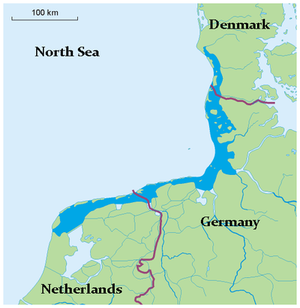
The Wadden Sea is an intertidal zone of the North Sea situated between the coast of northwestern continental Europe and the range of Frisian Islands.
The Wadden Sea comprises a shallow body of water of 1,350,600 hectares, with tidal mudflats, marshes and other wetlands. It exhibits high biodiversity, and in the year 2009, the Dutch and German parts of the Wadden Sea were inscribed on the World Heritage List.
The Wadden is one of the youngest seas of the world, not being inundated until the early Holocene; moreover, it is a sea whose coastline and islands have been most strongly influenced by humans, who created artificial near coastal islands to support an early Iron Age agricultural economy. In fact, human earthworks over the last three millennia have resulted in diking of most of the mainland coast as well as the Wadden Sea inboard side of the barrier islands.
An estimated 9.3 million herbivorous birds visit the Wadden Sea each year in migration and resting stops. The high variability in salinity and meterological parameters, combined with the extensive wetlands, has created an environment that provides habitat for over 250 endemic species. The largest extent of tidal flats in the world, this small sea accounted for sixty percent of all tidelands in the entirety of Europe and North Africa; in fact, over two thirds of the Wadden Sea are tidal flats.
Contents
Circulation and Hydrology
The outboard margin of the Wadden Sea is rimmed by approximately 50 barrier islands, 21 of which are of moderate size and 29 are somewhat small. The width of the Wadden Sea is 15 to 25 kilometres (km) wide, decreasing to three to four km wide in Germany. The width is ten to twelve km at the German Bight and about five km at Fano.
For the Dutch Wadden Sea the flushing time is high in relation to that of the deeper channels of sea. However, the reduction in mixing process intensity is less than what could be expected from values of tidal velocities. This situation could be due to a domination of the mixing by robust tidal mean circulations established by non-linear interactions of a tidal wave propagating over a complex bottom topography. The supposition of such circulations was first based on the extremely evident ebb surplus measured within all of the deeper parts, for which a compensating food surplus on the adjacent shoals was thought to exist.
In the East Frisian Wadden Sea, the shallow seabed slows the tidal signal north of the barrier islands. South of these barrier islands, total channel water volume is less than that of the tidal prism, and asymettry of the tidal signal is shifted towards ebb dominance, especially at spring tide. At the open northern boundary of the East Frisian Wadden Sea there are robust alongshore currents, with a net southward transport. This circulation pattern conforms with the field observation of sediment accumulation in the intertidal zone mudflats.
Significant ongoing deposition of sediment is occurring in the Wadden Sea, the source of this silt deriving chiefly from the North Sea, rather than direct terrestrial erosion. The majority of this deposition occurs along the inner margins and within the tidal watersheds of the mainland and nearshore islands. Net silt accumulation is presently taking place at the rate of approximately 800,000 tonnes per annum.
Water Quality
Water pollution issues that have plagued the Wadden Sea include excess turbidity, along with mainland runoff (Surface runoff) of pesticides, herbicides and agricultural nutrients. Massive amounts of dredge disposal near Hoek van Holland from 1970 to 1973 caused a major spike in turbidity during the 20th century; furthermore, aggressive cultivation of mussel stocks beginning in 1950 contributed further to the silt loading of the water column. Several bird species suffered substantial population declines in the 1960s due to excessive pesticide runoff.
Geological Origin
The area designated as the Wadden Sea is a relatively new water body, since early Holocene sea levels were much lower, and the continental landform has correspondingly undergone subsidence over the last 12,000 years. The earliest marine incursions in this area were paleo-channels that arose approximately 8000 years before present. Moreover, by 6500 years before present coastal sediment aggredation and sea-level rise reached competing rates, such that extensive salt marshes were created on the inboard side of the barrier islands.
Formation of the barrier islands is placed at approximately 6500 to 5000 years before present; the gaps between these islands are well correlated with the paleo-valleys tracing back to the Pleistocene.
Islands
Inside the North Frisian Wadden Sea, a number of Halligen islands (small salt marsh low lying landforms) and polder islands occur, of which Fohr has a Pleistocene core. Other islands that manifest a glacial Pleistocene core are Sylt, Texel and Amrum.
The chief Danish Wadden islands are Mando, Fano and Romo; in addition, two prominent sandbanks are Jordsand and Koresand. Some of these islands such as Mando have diked areas to allow water protected areas for sheep grazing. They have perimeters of expansive mudflats and marshes.
In addition to the natural islands within the Wadden Sea, humans have created a number of artificial islands near the mainland; these islands, called terpens, were constructed primarily in the epoch of 1000 BC to 500 AD. Most of these artificial islands are off the coasts of Friesland, Niedersachsen, Groningen and Schleswig-Holstein. For example the terpen near the mouth of the River Wesen was constructed at least as early as the first century BC; these islands allowed access to rich saltmarsh grazing areas that would otherwise not be accessible. Interestingly most of the houses excavated from circa 50 BC have their own granaries, indicating the significance of the individual family as an economic unit; there were also identifiable labourers' houses, which features denote the formation of separate social and economic classes at this stage of European development.
Ecology
Microbial mats in the marine environment cover 70 percent of the Earth's surface, and hence are a vital part of understanding primary productivity on our planet. The benthic micro-organism composition of the Wadden Sea has best been studied off the German coast. There the great majority of benthic microbes are found within the top five centimetres of silt. The microbial communities are dominated by Bacteria, whereas Archaea and Eucarya were detected only in numbers that remained below the experimental detection limit.
There are a number of mollusk species present in the Wadden Sea, the most commercially important being th Blue mussel, Mytilus edulis; peak annual landings of M. edulis have amounted to as much as 27,000 tonnes. Since this bivalve is an important prey of many bird species of the region, it is vital that the Blue mussel not be overharvested.
Over fifty species of migrating birds spend time in the Wadden Sea each year, making this a key resting and feeding area for Western European migrations. Avian species seen here include Pied avocet (Recurvirostra avosetta), Osprey (Pandion haliaetus), Barnacle goose (Branta leucopsis), Sandwich tern (Thalasseus sandvicensis) and Bar-tailed godwit (Limosa lapponica). On the dunes and marshes of the islands there are over 900 species of vascular plants, 300 Mosses, 650 fungi and 350 species of lichen found.
Conservation
The waters, islands and marshes of the Wadden Sea offer many ecological niches for birdlife and other biological resources. Correspondingly Dutch and German parts of the Wadden Sea were inscribed on the World Heritage List in the year 2009. Nation specific conservation actions have also been taken, since specific parts of the Wadden Sea have been denoted Ramsar sites and Important Bird Areas. In particular in Germany, the entire Hamburg area of Wadden Sea has been placed under the most stringent protection category of the Hamburg Nature Protection Act. In 1986 Niedersachsen placed the entirety of the German Niedersachsen Wadden Sea into national park status including the East Frisian Islands.
References
- Gavin Burnell. 2001. Coastal shellfish: a sustainable resource : proceedings of the Third International Conference on Shellfish Restoration, held in Cork, Ireland, 28 September - 2 October 1999 (Google eBook) Springer. 224 pages
- Dominic Couzens. 2008. Top 100 Birding Sites of the World. University of California Press. ISBN 978-0-520-25932-4.
- K.S Dijkema, Hans-Erich Reineck, Wim J.Wolff. 1980. Geomorphology of the Wadden Sea area: final report. A. A. Balkema. 135 pages
- Doeke Eisma, Dr. D. Eisma, Poppe Lubberts de Boer. 1998. Intertidal deposits: river mouths, tidal flats, and coastal lagoons. CRC Press. 525 pages
- Donald M. Kent. 2000. Applied wetlands science and technology. 454 pages. Google eBook. CRC Press. 454 pages
- Enric Llobet-Brossa, Ramon Rosselló-Mora and Rudolf Amann. 1998. Microbial Community Composition of Wadden Sea Sediments as Revealed by Fluorescence In Situ Hybridization. Appl Environ Microbiol. 64(7): 2691–2696. American Society for Microbiology
- Swie-Djin Nio, Tjeerd C. E. van Weering. 1981. Holocene marine sedimentation in the North Sea basin. John Wiley and Sons, 515 pages
- Richard C. Smardon. 2009. Sustaining the world's wetlands: setting policy and resolving conflicts. (Google eBook) Springer. 326 pages
- Emil V.Stanev, Jorg-Olaf Wolff, Hans Burchard, Karsten Bolding and Gotz Floser. 2003. On the circuation in the East Frisian Wadden Sea: numerical modeling and data analysis. Ocean Dynamics 53: 27-51
- Robert Van de Noort. 2011. North Sea Archaeologies: A Maritime Biography, 10,000 BC - AD 1500. Oxford University Press. 520 pages
- J.T.F..Zimmerman, 1974. Circulation and water exchange near a tidal watershed in the Dutch Wadden Sea. Neth. J. Sea Res. 8(2-3): 126-138