Victoria Nile
| Topics: |
Geology (main)
|
The Victoria Nile is a 260 mile section of the White Nile (one of the two major tributaries of the Nile River) beginning at northern shore of Lake Victoria and ending at Lake Albert in northwest Uganda.
[Image:Rivers_and_lakes_of_Uganda.png.jpeg|thumb|Rivers and lakes of Uganda. Source: Ezeu]]
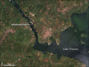

Until the 1950s, the Victoria Nile began as it flowed out of Lake Victoria over Rippon Falls west of Jinja. Rippon Falls are now submerged as a result of the building of Nalubaale (Owens) Dam in the mid-1950s and thus, the river is now considered to begin at that secondary point.
About 70 miles north of Lake Victoria the river widens and slows, becoming the large and shallow Lake Kyoga, which also receives water from eastern Uganda and the Kafu River from the west. This slow moving lake is fringed with swamps and is less than 12 feet (4 meters) deep in most places. Lake Kyoga and the surrounding basin dominate central Uganda. Extensions of Lake Kyoga include Lake Kwania, Lake Bugondo, and Lake Opeta. These "finger lakes" are surrounded by swampland during rainy seasons. All lakes in the Lake Kyoga Basin are shallow, usually reaching a depth of only eight or nine meters, and Lake Opeta forms a separate lake during dry seasons.
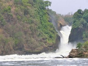
When the river exits Lake Kyoga 50 miles northwest from its entry point, the Victoria Nile turns from an easterly direction to the north, northwest, and north again, before turning east toward Lake Albert. The river passes through a number of rapids and falls. Most striking is Murchison Falls, 20 miles east of Lake Albert. Here, the river narrows, and at one point is reduced to a width of merely 20 feet (six meters) and cascades 400 feet (120 meters) in three stages .
The Victoria Nile enters Lake Albert along the border with the Democratic Republic of the Congo, near its northern end, where the next section of the Nile, the Albert Nile begins. The lake also receives the flow of several other rivers, most notably the Semliki River at its southern end. Lake Albert lies at the northern end of the Albertine rift, the western branch of the Great Rift System.
See Also
- Albert Nile
- Major rivers, lakes, mountains, and other terrestrial features of Uganda
- Uganda country profile
References
- Sir William Willcocks, Hugh John Llewellyn Beadnell. 1904. The Nile in 1904 (Google eBook) E.& F.N. Spon, limited, 225 pages
- Julian Rzóska. 1976. The Nile: biology of an ancient river 417 pages