Uruguayan savanna
The unique grasslands, palm savannas, and gallery forests of this ecoregion cover a vast area including the entire country of Uruguay.
Unfortunately, agriculture and cattle ranching have heavily altered these natural communities. The Uruguayan government, however, is acting to preserve what remains of the native flora in this ecoregion.
Location and General Description
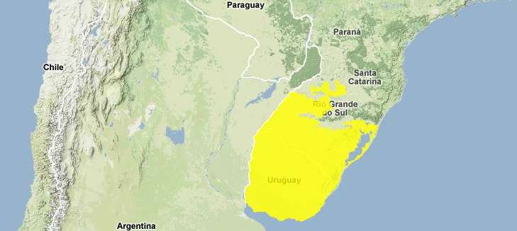
The Uruguayan savanna ecoregion extends from the extreme southern part of the Rio Grande do Sul, a Brazilian state, to include the entire country of Uruguay, and a small section of the Argentinean province of Entre Ríos. These savannas encompass a mosaic of gallery forests, palm savannas and out cropping of submontane forests. The gallery forests are found along the Uruguay, Negro, Yaguarí, Queguay, and Tacuarembo Rivers in the easternmost part of the ecoregion, while submontane forests and palm savannas are scattered throughout the ecoregion.
The complex geology of the ecoregion includes precambric, cretaceous and jurassic rocks, as well as more recent sedimentary rocks. Two-million year old metamorphic and magmatic rocks are predominant in the eastern side of the ecoregion. There is a two-hundred-kilometer-wide strip from the coastal area to the northern part of the ecoregion containing six-million year old metamorphic rocks.
Annual precipitation in the area ranges between 1,000 millimeters (mm) in the southern part, and 1,300 mm in the northern part of the ecoregion. The average temperature in the south is 16°C but is higher with an average of 19°C in the north. This large ecoregion is relatively flat, ranging from sea-level to elevations of about 500 meters in some areas.
The majority of the ecoregion includes medium-tall grasslands. In the Brazilian side these grasslands are called the campos limpos; there are almost no gallery forests on this side. The [[Uruguay]an] savannas include about 400 species of annual and perennial grasses. Some of the most common grasses are Aristida sp., Axonopus sp., Briza sp., Bromus aulecticus, B. unioloides, Eragrostis neesii, Eryanthus sp., Paspalum dilatatum, P. notatum, P. sanguinale, Sporobolus poiretti, Stenotaphrum secundatum, Schyzachirium sp., and Stipa sp. A dominant species in the northern areas with sandy soils is Andropogon lateralis. Common estival genera are Paspalum, Panicum, Rotboelia, Andropogon, Chloris, Sporoblus. Common hibernal genera are Stipa, Piptochaetum, Poa, and Bromus (Republica Oriental del.
The gallery forests are caused by an abundance of water in the soil. Dominant species found in these forests include Salix humboldtiana and Ruprenchtia salicifolia.
The palm savannas are located in areas where water accumulates. Some of the common grasses are Arsitida sp., Axonompus copressus, Eragrostis lagers, Panicum bergii, Paspalum notatum, P. urvillei. Among the palms are Acromia totati, Arecastrum romanzoffianum, Butia yatay Copernicia australis, Syagrus yatay, Trithrinax campestris. In areas permanently inundated with water the following species are found: Cyperus giganteus, Fuirena robusta, Scirpus californicus, Thalia geniculata, T. multiflora, and Typha domingensis.
Biodiversity Features
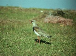
 Southern lapwing (Vanellu chilensis), Brazil (Photograph by WWF)
 The fauna in the area most closely resembles that of subtropical origin. Seventy-two species of mammals occur in this ecoregion including four marsupials, seventeen chiropterans, five xenarthrans, seventeen carnivores, two artiodactyls, and twenty rodents. Some of the native mammals in the savannas are the pampas deer (Ozotoceros bezoarticus), Guazauvirá deer (Mazama gouazoubira) and capybara (Hydrochoerus hydrochaeris). Most of the mammals from this ecoregion are found in the gallery forests along the Uruguay River and in the small ravines of the north. The majority of the avian fauna (400 species) is concentrated in wetlands. Only 80 species of birds inhabit the savannas. There has been a recent decline in the numbers of the endangered greater rhea (Rhea americana) in this ecoregion. Other endangered birds that utilize this and neighboring ecoregions include the ochre-breasted pipit (Anthus nattereri), yellow cardinal (Gubernatrix cristata), saffron-cowled blackbird (Xanthopsar flavus), and pampas meadowlark (Sturnella militaris).
Near-endemic birds that utilize this ecoregion as well as the Humid Pampas and Southern Cone Mesopotamian savannas ecoregions include two threatened species: marsh seedeater (Sporophila palustris), Entre Ríos seedeater (S. zelichi), and one near threatened species: chestnut seedeater (S. cinnamomea). The three species are patchily distributed east in the ecoregion, and in southeast Uruguay; they are found in low, seasonally wet grassland, and freshwater marshes. The marsh and Entre Ríos seedeaters are also found in riparian thickets.
There is one endemic palm: palma yatay (Butia yatay), found also in the Mesopotamian savannas ecoregion.
Current Status
The savannas are critically endangered due to the fact that there are few small isolated patches of intact habitat remaining. The whole ecoregion has been severely altered by cattle ranching- one of the main pillars of the national economy in Uruguay. About 80% of Uruguayan territory is used for cattle ranching on natural and artificial savannas. Over-grazing with unequal distribution of cattle in some areas has degraded the natural vegetation in the savannas. Artificial grasslands increased by 32% between 1980 and 1990 in Uruguay. The historical extension of the palm savannas was much greater than the isolated patches found today. The palm savannas have been greatly affected by grazing. Only adult and old palms are left; livestock feeding on the young palms has stopped their regeneration.
Habitat destruction and modification, and introduction of alien species to the ecoregion have caused the extinction of the collared peccary (Tayassu tajacu), the giant anteater (Myrmecophaga tridactyla), tamandua (Tamandua tetradactyla), jaguar (Panthera onca), and jaguarundi (Herpailurus yaguarondi). Among some of the introduced species are the axis deer (Axis axis), fallow deer (Dama dama), European hare (Lepus europeous) and wild boar (Sus scrofa).
The use of fertilizers has increased in pasturelands and agricultural crops. It is estimated that 53% of the agricultural lands use fertilizers in Uruguay. The introduction of fertilizers, pesticides and herbicides has effected food chains at the terrestrial and aquatic levels in the area.
The Uruguayan government identified 36 areas for wildlife protection. The current status of the national parks is poor. There are 15 protected areas that have been highly degraded, and are not adequate for protection of native species. There are also areas that do not protect the native fauna and flora in the ecoregion but instead introduced species, such is the case of the Roosevelt National Park with eucalyptus as the dominant species.
Types and Severity of Threats
Continuous excessive grazing by livestock and conversion of natural [[habitat]s] for agriculture threaten the few remaining isolated patches of grasslands and forests. Soil erosion due mainly to agriculture activities is one of the major threats. The western portion of the ecoregion is threatened by logging. Thirty-one tons of top soil per hectare was lost in one year in the territory of Uruguay. Sporophila zelichi and S. palustris are threatened because of habitat destruction, as well as trapping. The males are popular cage-birds.
Justification of Ecoregion Delineation
These savannas of southern-most Brazil, all of Uruguay, and portions of Argentina have been severely modified by agriculture and other human-modified landscape. To derive the linework we followed a number of sources. In Brazil we followed the IBGE map classifications of , and lumped the following categories: "woody-grass (Gramineae) savanna", "woody-grass (Gramineae) savanna steppe", "woody-grass (Gramineae) steppe", "agricultural activities" (in all classifications), "savanna-steppe", "savanna-savanna steppe", "savanna-park", and "open tree savanna". For the historic coverages of Uruguay we consulted Republica Oriental del Uruguay et al.
Additional Information on this Ecoregion
- For a shorter summary of this entry, see the WWF WildWorld profile of this ecoregion.
- To see the species that live in this ecoregion, including images and threat levels, see the WWF Wildfinder description of this ecoregion.
- World Wildlife Fund Homepage
Further Reading
- Fundação Instituto Brasilero de Geografia Estatástica-IBGE. 1993. Mapa de vegetação do Brasil. Map 1:5,000,000. Rio de Janeiro, Brazil.
- Grau, R. 1996. Uruguayan savannas. Identifying Gaps in Botanical Information for Biodiversity Conservation in Latin America and the Caribbean Proceedings of a Workshop. Washington, DC. WWF, Washington, DC.
- Gudynas, E. 2000. Preservando Nuestras Areas Naturales. Website Retrieved (2001).
- Republica Oriental del Uruguay, OEA, and BID. 1992. Estudio Ambiental Nacional: Plan de Accion Ambiental. Organizacion de los Estados Americanos, Washington, DC.
- Stattersfield, A.J., M. J. Crosby, A. J. Long, and D. C. Wege, editors. 1998. Endemic bird areas of the World: Priorities for biodiversity conservation. BirdLife International, Cambridge, UK. ISBN: 1560985747
- UNESCO. 1981. Vegetation Map of South America: Explanatory Notes. UNESCO, Paris. ISBN: 923001933X
| Disclaimer: This article is taken wholly from, or contains information that was originally published by, the World Wildlife Fund. Topic editors and authors for the Encyclopedia of Earth may have edited its content or added new information. The use of information from the World Wildlife Fund should not be construed as support for or endorsement by that organization for any new information added by EoE personnel, or for any editing of the original content. |

