Uganda
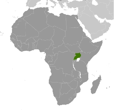
Countries and Regions of the World Collection  Uganda is a landlocked nation of thirty-six million people in eastern-Africa, that straddles the equator, west of Kenya, south of Sudan, with Rwanda and Tanzania to the south. It is a fertile, well-watered country with many lakes and rivers.
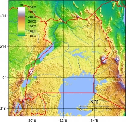
Uganda's western border with the Democratic Republic of the Congo is defined by the Albertine rift, the western branch of the Great Rift System of Africa.
This Rift valley boundary area includes two of African Great Lakes, Lake Albert and Lake Edward, the snow-capped Ruwenzori mountains (considered by many to be the legendary "Mountains of the Moon"), as well as many imperiled species, like the Mountain gorilla.
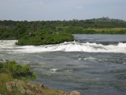
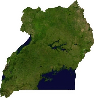
Uganda is a fertile, well-watered country with many lakes and rivers, including a sizable part of Lake Victoria (a fifth of the country's area is water).
The country is mostly plateau declining in to the north and rimmed with highlands and mountains and volcanoes.
Uganda's major environmental issues are rooted in meeting the human needs for land, firewood, and other natural resources for a rapidly growing population (3.6% per year). Issues include:
- draining of wetlands for agricultural use;
- deforestation;
- overgrazing;
- soil erosion;
- water hyacinth infestation in Lake Victoria; and,
- widespread poaching
The country's environmental challenges have been exacerbated by regional wars and civil unrest.
The colonial boundaries created by Britain to delimit Uganda grouped together a wide range of ethnic groups with different political systems and cultures. These differences prevented the establishment of a working political community after independence was achieved in 1962.
The dictatorial regime of Idi Amin (1971-79) was responsible for the deaths of some 300,000 opponents; guerrilla war and human rights abuses under Milton Obote (1980-85) claimed at least another 100,000 lives.
The rule of Yoweri Museveni since 1986 has brought relative stability and economic growth to Uganda. During the 1990s, the government promulgated non-party presidential and legislative elections.
Uganda is subject to armed fighting among hostile ethnic groups, rebels, armed gangs, militias, and various government forces that extend across its borders/ Uganda hosts 209,860 Sudanese, 27,560 Congolese, and 19,710 Rwandan refugees.
The vicious and cult-like Lord's Resistance Army (LRA) operated from 1986 to 2006 in northern Uganda, where it killed tens of thousands of people, abducted thousands of children to serve as soldiers and slaves, and displaced approximately 1.8 million Ugandans. In 2005, the Ugandan military pushed the LRA out of northern Uganda and into neighboring Democratic Republic of the Congo (D.R.C.). In December 2008, the Governments of Uganda, the D.R.C., and Southern Sudan launched a joint military operation against the LRA in northeastern D.R.C., dispersing groups of LRA fighters across the D.R.C., Central African Republic, and Southern Sudan (now South Sudan), where the group continues to commit atrocities against local populations. In 2011, the United States sent a small number of military advisers to the LRA-affected region to enhance the capacity of the Ugandan and other regional militaries to pursue the LRA and protect civilian populations.
There have been no LRA attacks in northern Uganda since August 2006. As a result, the vast majority of the 1.8 million former internally displaced persons (IDPs) have returned to or near their homes. Assistance from the Government of Uganda through its Peace, Recovery and Development Plan (PRDP) and from international donors has helped communities in northern Uganda rebuild and recover from the 20-year humanitarian catastrophe caused by the LRA.
After decades of internal strife, Uganda has experienced more than 20 years of relative political stability and economic growth. However, rampant corruption and one of the world’s highest population growth rates present challenges to the country’s continued economic growth and political stability.
Contents
Geography
Location: Eastern Africa, west of Kenya and east of the Democratic Republic of the Congo (whose border region is part of the Albertine rift)
Geographic Coordinates: between latitudes 4o12' N and 1o29'S and longitudes 29o35'E and 35o00'E
Area: 236,040 km2 (199,710 km2 land and 36,330 km2 water)
arable land: 21.57%
permanent crops: 8.92%
other: 69.51% (2005)
Land Boundaries: 2,698 km. Border countries: Democratic Republic of the Congo 765 km, Kenya 933 km, Rwanda 169 km, South Sudan 435 km, Tanzania 396 km
Coastline: 0 km (landlocked)
Maritime Claims: none (landlocked)
Natural Hazards: NA
Terrain: Mostly plateau with rim of mountains. Its lowest point is Lake Albert (621 metres) and its highest point is Margherita Peak on Mount Stanley (5,110 metres)
Climate: Tropical; generally rainy with two dry seasons (December to February, June to August); semiarid in northeast
See: Environmental Issues and Natural Resources of Uganda
|
|
Ecology
|
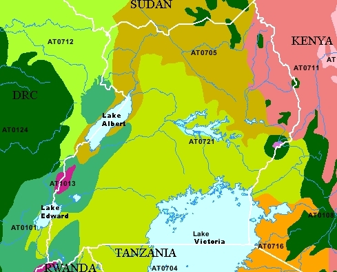
The following WWF ecoregions are found in Uganda: 1. Victoria Basin forest-savanna mosaic (AT0721) covers much of Uganda spreading north and east from Lake Victoria. 2. East Sudanian savanna (AT0705) reaches down from the north to encompass much of northern Uganda and reaching further south to encompass Lake Albert in the west to near Mount Elgon National Park in the east. 3. Albertine Rift montane forests (AT0101) in the west of Urganda represent the largest ecoregion in the Albertine rift, particularly in the middle section. These mountains also support the Mountain gorilla, which is one of the most charismatic flagship species in Africa, and an effective target for much of the current conservation investment in the area. 4. Ruwenzori-Virunga montane moorlands (AT1013) occur mostly above 9,800 feet (3,000 m) in two areas atop the Ruwenzori and Virunga mountains. 5. East African montane forests (AT0108) are found mostly in Kenya to the east, however,six smaller area of this ecoregion occur in Uganda, most notably, encircling Mount Elgon on the border with Tanzania. |
Source: World Wildlife Fund |
- Northern Acacia-Commiphora bushlands and thickets (AT0711) cover a large area of eastern Uganda and and across the border in Kenya.
- Northern Congolian forest-savanna mosaic (AT0712) touches upon a small are of Uganda's western Albertine rift region from the north east where its large extent covers the norther east of the DRC and the south west of Sudan.
National Parks
- Bwindi Impenetrable National Park
- Kibale National Park
- Kidepo Valley National Park
- Lake Mburo National Park
- Mgahinga Gorilla National Park
- Mount Elgon National Park
- Murchison Falls National Park
- Queen Elizabeth National Park
- Rwenzori Mountains National Park
- Semuliki National Park
|
|
|
|
|
|
|
|
|
|
|
|
|
|
|
|
|
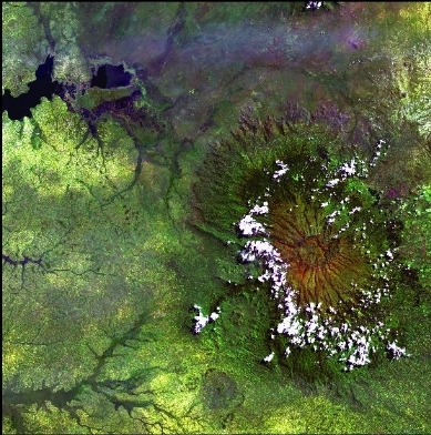
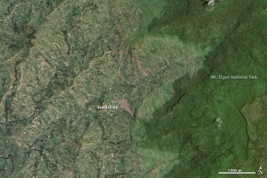
Heavy rains triggered these landslides on the steep slopes of Mt. Elgon in Uganda, on March 1, 2010. The newly exposed earth is slightly pink, raw compared to other patches of bare ground, which are lighter brown. As the older scars hint, landslides are common in the region, but the new landslides are much larger than previous slides. The slides buried three villages, leaving 83 dead and more than 300 missing as of March 8, reported the United Nations Office for the Coordination of Humanitarian Affairs. This natural-color image, acquired by the Advanced Land Imager on NASA’s Earth Observing-1 (EO-1) satellite on March 11, 2010, provides clues that the landslide area had been populated. Bright roofs reflect light extremely well. Tiny white dots scattered across the western slopes of Mt. Elgon are probably structures. Several structures surround the slides. Heavy rain caused the slides, but deforestation may have also played a role, said the Ugandan government. Dark green forest grows on the slope above the slide area. A strip of pale green land, free of settlements, separates the forest from the slide. This region had been deforested since 2007, according to the government analysis. On a steep slope, trees anchor the soil. Deforested mountains are very prone to landslides. Source: NASA. Credit: NASA Earth Observatory image created by Jesse Allen, using EO-1 ALI data provided courtesy of the NASA EO-1 team. Caption by Holli Riebeek. |
People and Society
Population: 35,873,253 (July 2012 est.)
Ethnic groups: Baganda 16.9%, Banyakole 9.5%, Basoga 8.4%, Bakiga 6.9%, Iteso 6.4%, Langi 6.1%, Acholi 4.7%, Bagisu 4.6%, Lugbara 4.2%, Bunyoro 2.7%, other 29.6% (2002 census)
Uganda's population is predominately rural, and its population density is highest in the southern regions. Asians constituted the largest nonindigenous ethnic group in Uganda until 1972, when the Idi Amin regime expelled 50,000 Asians who had been engaged in trade, industry, and various professions. After Amin's overthrow in 1979, Asians slowly began returning, but Uganda's Asian population has never reached its pre-1972 numbers.
Age Structure:
0-14 years: 49.9% (male 8,692,239/female 8,564,571)
15-64 years: 48.1% (male 8,383,548/female 8,255,473)
65 years and over: 2.1% (male 291,602/female 424,817) (2011 est.)
Population Growth Rate: 3.582% (2012 est.) - the fourth highest in the world after Qatar, Zimbabwe, and Niger.
Birth Rate: 47.38 births/1,000 population (2012 est.)
Death Rate: 11.54 deaths/1,000 population (July 2012 est.)
Net Migration Rate: -0.02 migrant(s)/1,000 population (2012 est.)
Life Expectancy at Birth: 52.34 years (2008 est.)
Total Fertility Rate: 6.81 children born/woman (2008 est.)
Languages: English (official national language, taught in grade schools, used in courts of law and by most newspapers and some radio broadcasts), Ganda or Luganda (most widely used of the Niger-Congo languages, preferred for native language publications in the capital and may be taught in school), other Niger-Congo languages, Nilo-Saharan languages, Swahili, Arabic
Literacy (2002 census): 66.8% (male: 76.8% - female: 57.7%)
Urbanization: 13% of total population (2010) growing at an annual rate of change of 4.8% (2010-15 est.)
History
Britain granted internal self-government to Uganda in 1961, with the first elections held on March 1, 1961. Benedicto Kiwanuka of the Democratic Party became the first Chief Minister. Uganda maintained its Commonwealth membership. A second round of elections in April 1962 elected members to a new National Assembly. Milton Obote, leader of the majority coalition in the National Assembly, became prime minister and led Uganda to formal independence on October 9, 1962.
In succeeding years, supporters of a centralized state vied with those in favor of a loose federation and a strong role for tribally-based local kingdoms. Political maneuvering climaxed in February 1966, when Prime Minister Milton Obote suspended the constitution, assumed all government powers, and removed the ceremonial president and vice president. In September 1967, a new constitution proclaimed Uganda a republic, gave the president even greater powers, and abolished the traditional kingdoms. On January 25, 1971, Obote's government was ousted in a military coup led by armed forces commander Idi Amin Dada. Amin declared himself president, dissolved the parliament, and amended the constitution to give himself absolute power.
Idi Amin's 8-year rule produced economic decline, social disintegration, and massive human rights violations. The Acholi and Langi ethnic groups were particular objects of Amin's political persecution because they had supported Obote and made up a large part of the army. In 1978, the International Commission of Jurists estimated that more than 100,000 Ugandans had been murdered during Amin's reign of terror; some estimates place the figure much higher.
In October 1978, Tanzanian armed forces repulsed an incursion of Amin's troops into Tanzanian territory. The Tanzanian force, backed by Ugandan exiles, waged a war of liberation against Amin's troops and Libyan soldiers sent to help him. On April 11, 1979, Kampala was captured, and Amin fled with his remaining forces.
After Amin's removal, the Uganda National Liberation Front formed an interim government with Yusuf Lule as president. This government adopted a ministerial system of administration and created a quasi-parliamentary organ known as the National Consultative Commission (NCC). The NCC and the Lule cabinet reflected widely differing political views. In June 1979, following a dispute over the extent of presidential powers, the NCC replaced Lule with Godfrey Binaisa. In a continuing dispute over the powers of the interim presidency, Binaisa was removed in May 1980. Thereafter, Uganda was ruled by a military commission chaired by Paulo Muwanga. December 1980 elections returned the UPC to power under the leadership of President Obote, with Muwanga serving as vice president. Under Obote, the security forces had one of the world's worst human rights records. In their efforts to stamp out an insurgency led by Yoweri Museveni's National Resistance Army (NRA), they laid waste to a substantial section of the country, especially in the Luwero area north of Kampala.
Obote ruled until July 27, 1985, when an army brigade, composed mostly of ethnic Acholi troops and commanded by Lt. Gen. Basilio Olara-Okello, took Kampala and proclaimed a military government. Obote fled to exile in Zambia. The new regime, headed by former defense force commander Gen. Tito Okello (no relation to Lt. Gen. Olara-Okello), opened negotiations with Museveni's insurgent forces and pledged to improve respect for human rights, end tribal rivalry, and conduct free and fair elections. In the meantime, massive human rights violations continued as the Okello government murdered civilians and ravaged the countryside in order to destroy the NRA's support.
Negotiations between the Okello government and the NRA were conducted in Nairobi in the fall of 1985, with Kenyan President Daniel Moi seeking a cease-fire and a coalition government in Uganda. Although agreeing in late 1985 to a cease-fire, the NRA continued fighting, seized Kampala in late January 1986, and assumed control of the country, forcing Okello to flee north into Sudan. Museveni's forces organized a government with Museveni as president and dominated by the political grouping called the National Resistance Movement (NRM or the "Movement").
A referendum was held in March 2000 on whether Uganda should retain the Movement system, with limited operation of political parties, or adopt multiparty politics. Although 70% of voters endorsed retention of the Movement system, the referendum was widely criticized for low voter turnout and unfair restrictions on Movement opponents. Museveni was reelected to a second 5-year term in March 2001. Parliamentary elections were held in June 2001, and more than 50% of contested seats were won by newcomers. Movement supporters nevertheless retained firm control of the legislative branch. Observers believed that the 2001 presidential and parliamentary elections generally reflected the will of the electorate; however, both were marred by serious irregularities, particularly in the period leading up to the elections, such as restrictions on political party activities, incidents of violence, voter intimidation, and fraud.
A July 2005 national referendum resulted in the adoption of a multiparty system of government, but in September 2005 Uganda's parliament amended the constitution to remove term limits for the president, enabling President Museveni to run again in the 2006 elections. In February 2006, the country held its first multiparty general elections since 1980. Ruling NRM candidate President Museveni was declared the winner with 59% of the vote, giving him a third term in office. Opposition Forum for a Democratic Change (FDC) leader Kizza Besigye captured 37% of the vote, while the remaining contestants received less than 2% of the vote each, according to official figures from the Electoral Commission. Besigye challenged the results in Uganda's Supreme Court, which ruled that serious irregularities had occurred but were not significant enough to alter the outcome of the elections.
On February 18, 2011, Uganda held its fourth presidential and parliamentary elections since Museveni came to power. Seven opposition presidential candidates, including FDC leader Kizza Besigye (the Inter-Party Cooperation candidate) ran against Museveni. On February 20, the Electoral Commission declared Museveni the winner with 68% of the vote; Kizza Besigye came in second with 26% of the vote.
Government
Government Type: Republic
Capitol: Kampala - 1.535 million (2009)
Administrative Divisions: 112 districts; Abim, Adjumani, Agago, Alebtong, Amolatar, Amudat, Amuria, Amuru, Apac, Arua, Budaka, Bududa, Bugiri, Buhweju, Bukedea, Bukomansimbi, Bukwa, Bulisa, Bundibugyo, Bushenyi, Busia, Butaleja, Butambala, Buvuma, Bwikwe, Dokolo, Gombe, Gulu, Hoima, Ibanda, Iganga, Isingiro, Jinja, Kaabong, Kabale, Kabarole, Kaberamaido, Kalangala, Kaliro, Kalungu Kampala, Kamuli, Kamwenge, Kanungu, Kapchorwa, Kasese, Katakwi, Kayunga, Kibale, Kiboga, Kibingo, Kibuku, Kiruhara, Kisoro, Kitgum, Kiryandongo, Koboko, Kole, Kotido, Kumi, Kwene, Kyegegwa, Kyenjojo, Lamwo, Lira, Luuka, Luwero, Lwengo, Lyantonde, Manafwa, Maracha, Masaka, Masindi, Mayuge, Mbale, Mbarara, Mitooma, Mityana, Moroto, Moyo, Mpigi, Mubende, Mukono, Nakapiripirit, Nakaseke, Nakasongola, Namayingo, Namutumba, Napak Nebbi, Ngora, Nsika, Ntoroko, Ntungamo, Nwoyo, Nyadri, Otuke, Oyam, Pader, Pallisa, Patongo, Rakai, Rubirizi, Rukungiri, Sembabule, Sheema, Sironko, Soroti, Tororo, Wakiso, Yumbe, Zombo
Independence Date: 9 October 1962 (from UK)
Legal System: mixed legal system of English common law and customary law. Uganda accepts compulsory International Court of Justice ( ICJ) jurisdiction with reservations; and, accepts International Criminal Court (ICCt) jurisdiction
Suffrage: 18 years of age; universal
International Environmental Agreements
Uganda is party to international agreements on: Biodiversity, Climate Change, Climate Change-Kyoto Protocol, Desertification, Endangered Species, Hazardous Wastes, Law of the Sea, Marine Life Conservation, Ozone Layer Protection, and Wetlands, It has signed, but not ratified an international agreement on Environmental Modification.
Water
Total Renewable Water Resources: 66 cu km (1970)
Freshwater Withdrawal: Total: 0.3 cu km/yr (43% domestic, 17% industrial, 40% agricultural).
Per Capita Freshwater Withdrawal: : 10 cu m/yr (2002)
Access to improved drinking waters sources: 67% of population
Access to improved sanitation facilities: 48% of population
Agriculture
Agricultural Products: coffee, tea, cotton, tobacco, cassava (tapioca), potatoes, corn, millet, pulses, cut flowers; beef, goat meat, milk, poultry
Irrigated Land: 90 sq km (2003)
Resources
Natural Resources: copper, cobalt, hydropower, limestone, salt, arable land.
Energy
Uganda is an energy poor nation with limited access to electricity (less than 10% of the population, 3% in rural areas) and a heavy reliance of wood for the needs of most Ugandans. This is connected to economic poverty and continuing deforestation.
A drop in the water level of Lake Victoria in 2005/6 led to a major reduction in the nation's electricity supply and an energy crisis. Uganda has rapidly expanded and diversified its energy supplies away from its near exclusive reliance of two hydroelectric facilities, but still has a supply shortfall.
New energy hydroelectric and fossil fuel electric generating facilities are projected to come online over the next few years. Oil has recently been discovered in the western part of the country.
Oil experts estimate Uganda’s Albertine Basin has about 2.5 billion barrels of recoverable oil, positioning Uganda to become one of sub-Saharan Africa’s top oil producers and potentially doubling current government revenues within 10 years. Most of Uganda’s known oil reserves are located along Lake Albert and the D.R.C. border, in one of Africa’s most ecologically sensitive areas. Uganda and several private oil companies had hoped to begin small-scale production as early as 2012, but production has been delayed due to a capital gains tax dispute and a parliamentary resolution blocking new agreements with oil companies pending passage of oil legislation. Potential construction of a domestic oil refinery and export pipeline are contingent upon ongoing feasibility studies and negotiations between oil companies and the government.
These developments should help Uganda sustain the brisk economic growth experienced during much of the past two decades and broaden the access to modern energy supplies. However, growing Uganda's energy supplies include significant financial and environmental challenges.
Economy
Uganda has substantial natural resources, including fertile soils, regular rainfall, small deposits of copper, gold, and other minerals, and recently discovered oil. Uganda has never conducted a national minerals survey.
Agriculture is the most important sector of the economy, employing over 80% of the work force. Coffee accounts for the bulk of export revenues.
Since 1986, the government - with the support of foreign countries and international agencies - has acted to rehabilitate and stabilize the economy by undertaking currency reform, raising producer prices on export crops, increasing prices of petroleum products, and improving civil service wages. The policy changes are especially aimed at dampening inflation and boosting production and export earnings.
Since 1990 economic reforms ushered in an era of solid economic growth based on continued investment in infrastructure, improved incentives for production and exports, lower inflation, better domestic security, and the return of exiled Indian-Ugandan entrepreneurs.
Uganda has received about $2 billion in multilateral and bilateral debt relief. In 2007 Uganda received $10 million for a Millennium Challenge Account Threshold Program.
The global economic downturn has hurt Uganda's exports; however, Uganda's GDP growth is still relatively strong due to past reforms and sound management of the downturn.
Oil revenues and taxes will become a larger source of government funding as oil comes on line in the next few years.
The service sector was the largest contributor to GDP in 2010 (at 50%). Manufacturing and agriculture contributed 26% and 24%, respectively. Despite their dwindling shares of Uganda’s GDP, the agriculture and fishing sectors provide approximately 80% of employment in Uganda. Uganda is Africa's second-leading producer of coffee, which accounted for about 17% of the country's exports in 2009 and 2010. Exports of nontraditional products, including apparel, hides, skins, vanilla, vegetables, fruits, cut flowers, and fish, are growing, while traditional exports such as cotton, tea, and tobacco continue to be mainstays.
Most industry is related to agriculture. The industrial sector has been rehabilitated and resumed production of building and construction materials, such as cement, reinforcing rods, corrugated roofing sheets, and paint. Domestically-produced consumer goods include plastics, soap, cork, beer, and soft drinks.
Rising food and fuel prices in 2011 led to protests. Instability in southern Sudan is a risk for the Ugandan economy in 2012 because Uganda's main export partner is Sudan, and Uganda is a key destination for Sudanese refugees.
GDP (Purchasing Power Parity): $45.9 billion (2011 est.)
GDP (Official Exchange Rate): $16 billion (2011 est.)
GDP- per capita (PPP): $1,300 (2011 est.)
GDP- composition by sector:
agriculture: 21.8%
industry: 26.1%
services: 52.1% (2011 est.)
Industries: sugar, brewing, tobacco, cotton textiles; cement, steel production
Exports: coffee, fish and fish products, tea, cotton, flowers, horticultural products; gold
Imports: capital equipment, vehicles, petroleum, medical supplies; cereals
Currency: Ugandan shilling (UGX)
Ports and Terminals: Entebbe, Jinja, Port Bell
Roads are the most commonly used transportation infrastructure in Uganda, accounting for more than 90% of cargo freight and passenger transportation. Uganda has about 78,100 kilometers (48,529 mi.) of roads. Only 3,000 kilometers (1,864 mi.) are paved, and most roads radiate from Kampala. The country has a 321 kilometer (200 mi.) rail network, much of which is not currently in use. Uganda's road and rail links to Mombasa serve some of the transportation needs of the neighboring countries of Rwanda, Burundi, and parts of D.R.C. and Sudan. Entebbe International Airport is on the shore of Lake Victoria, some 32 kilometers (20 mi.) south of Kampala.
