Northern Acacia-Commiphora bushlands and thickets
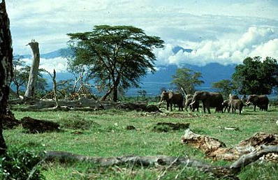
Amboseli National Park, Kenya. (Photograph by WWF/ Mauri Rautkari)
Introduction The ecoregion, comprised of semi-arid mixed woodland, scrub and grassland, is reasonably protected within a well-functioning system of national parks and other reserves. However, numbers of humans and livestock are increasing outside protected areas, and nomadic pastoralism is declining in favor of settlement, causing environmental degradation through heavy grazing and agricultural (Northern Acacia-Commiphora bushlands and thickets) expansion. Water is always in short supply in this region, where one or both rainy seasons commonly fail. Certain species such as Grevy’s zebra (Equus grevyi) have undergone severe declines because of competition with livestock for, and often exclusion from, water supplies. Poaching also threatens some of the large herbivores found here, particularly the black rhinoceros (Diceros bicornis) and, until recently, the African elephant (Loxodonta africana).
Location and General Description
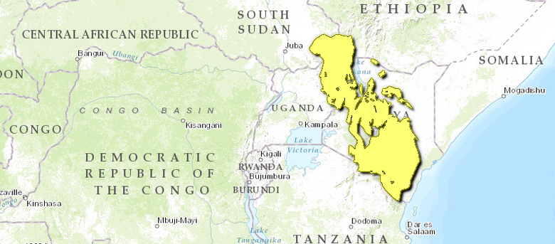
This ecoregion extends from the southeast corner of Sudan and northeast Uganda, through much of lowland Kenya, reaching as far as the border with the Northern Zanzibar-Inhambane Coastal Forest Mosaic. To the north, it is replaced by drier savanna and semi-desert vegetation. To the south it grades into the southern Acacia-Commiphora bushland and thicket around the Kenya-Tanzania border.
 WWF Climatically, the area falls within the seasonal tropics, with seasonality controlled by movement of the Inter Tropical Convergence Zone. Mean maximum temperatures are 30°C in the lowlands, falling to around 24°C in the higher areas. Mean minimum temperatures range from 18 to 21°C. Annual rainfall ranges from 200 milimeters (mm) in the drier areas near Lake Turkana, to about 600 mm closer to the Kenyan Coast. It is strongly seasonal, with most precipitation occurring in the long rains, typically from March to June, and less falling in the short rains of October to December. The timing and amounts of rainfall vary greatly from year to year, and it is fairly common that one, or both, rainy seasons fail. In Turkana, Kenya, and southern Sudan, there is typically one rainy period per year. During drier times the desiccated vegetation becomes highly flammable and large areas of the ecoregion burn every year.
Geologically, the ecoregion is situated on a mixture of basement rocks. These range from Precambrian basement, through Tertiary volcanic lavas, to Quaternary basin and dune formations. These sediments outcrop at the surface in many places due to the shallow soils. Apart from these outcrops, the ecoregion is generally level and gently undulating, with lowest elevation in the east, north and northwest (elevations of 200 meters (m) to 400 m), increasing towards the south and southwest, where elevations rise up to 1,000 m, but there are a number of notable mountains, such as Moroto in Uganda, which exceeds 3000 m, and several in Turkana which are above 2000 m. The soils of the southeast portion of the ecoregion are mainly aridisols, with entisols around Lake Turkana Basin. Along the western margins of the ecoregion, vertisols can also be found.
The ecoregion is part of White’s Somali-Masai regional center of phytogeographical endemism and is predominately Acacia-Commiphora bushland and thicket. Common plant genera include Acacia, Commiphora, and Boswellia, and Aristida, Stipa, and Chloris grasses.
Biodiversity Features
This region is essentially a transition zone between the drier Somali ''Acacia-Commiphora'' Bushland and Thicket ecoregion to the north and the wetter Southern ''Acacia-Commiphora'' Bushland and Thicket ecoregion to the south. Much of the flora and fauna overlap from these adjacent regions, resulting in a mixture of drought-adapted and tropical savanna species. While the dry climate means that there is an insufficient vegetation base to sustain the vast migratory herds of large mammals found in the south, it is too wet to be inhabited solely by the more arid-adapted species found in the north. Despite being semi-arid, biodiversity studies in southern Karamoja testify to the species richness of the area.
_in_Buffalo_Springs_National_Reserve%2c_Kenya.jpg) Gerenuk (Litocranius walleri) in Buffalo Springs National Reserve, Kenya. (Photograph by Mary Rowen)
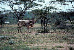
Gerenuk (Litocranius walleri) in Buffalo Springs National Reserve, Kenya. (Photograph by Mary Rowen) Mammalian species diversity in this ecoregion is high. Few species are strictly endemic, however, and those that are, are rodents: three gerbils; Cosens’ gerbil (Gerbillus cosensi, CR), diminutive gerbil (G. diminutus), and Percival’s gerbil (G. percivali), and an Acacia rat (Thallomys loringi). The ecoregion also features several species of arid-adapted ungulate: the endangered Grevy’s zebra (Equus grevyi), beisa oryx (Oryx gazella beisa), gerenuk (Litocranius walleri) and lesser kudu (Tragelaphus imberbis).
The ecoregion has a rich avian fauna. Endemism is low, and the majority of species are found elsewhere in East Africa or are European and Asian migrants. Strict endemics are Friedmann's lark (Mirafra pulpa, DD), Williams' lark (Mirafra williamsi, DD), and Hinde's pied-babbler (Turdoides hindei, VU). The same is generally true for reptiles; there is a rich fauna but the number of endemic species is quite low. Strictly endemic reptiles are Scheffler's dwarf gecko (Lygodactylus scheffleri), side spotted dwarf gecko (Lygodactylus laterimaculatus), and Amblyodipsas teitana. One amphibian is believed strictly endemic to the area, Hyperolius sheldricki.
 Buffalo Springs National Reserve, Kenya. (Photograph by Mary Rowen)
 Elephants are major architects of woodland-savanna habitats because they are large browsers and frequently knock down trees for forage. This opens and transforms woodlands into grassland savannas. With lower elephant densities, grasslands change into woodland thickets. The ratio of woodland-to-savanna affects both plant and animal species composition and densities, so the elephant is extremely important in this ecosystem. The elephant population here is now considered relatively stable, although between 1975 and 1980, elephant numbers in Tsavo National Park declined from nearly 35,000 to about 14,000. This decline was the result of a period of drought followed by heavy poaching. Tsavo N.P. now contains an estimated 7,400 animals. The international ban on ivory trading imposed by CITES is thought to have been crucial in reducing poaching. Much of our knowledge about African elephants comes from long-term studies in Amboseli and Tsavo National Parks, which are located in this ecoregion. In addition to elephants, fire also keeps grasslands open. Although fire occurs naturally, burning by pastoralists has increased its frequency.
Once numerous in the central and southern portions of this ecoregion, the endangered black rhinoceros (Diceros bicornis) has been extirpated in much of East Africa. Of an estimated 65,000 individuals present in the 1960s, only about 420 remain in all of Kenya. The situation for black rhino in East Africa is dire: these 420 animals represent as much as 88% of the region’s surviving population. Today, the surviving east African black rhinos exist primarily in heavily guarded areas of national parks and fenced sanctuaries, many of which are located in this ecoregion. Wild dogs (Lycaon pictus) have suffered the fastest and greatest range contraction of all of Africa’s carnivores, through loss of habitat to livestock, direct persecution and diseases contracted from domestic dogs. Wild dogs once ranged over most of Sub-Saharan Africa, excluding forest and desert areas. Now, for the most part, they do not even occur in protected areas. Within this ecoregion, they are now extinct in Amboseli and Nairobi National Parks (NP), as well as Buffalo Springs National Reserve (NR). They are listed as "Vagrant" in Samburu NR, "Rare" in South Turkana NR and Tsavo West NP and "Uncommon"in Tsavo East NP. They have been seen outside of protected areas, in Kajiado district and near Laikipia, suggesting that these packs are in danger of conflict with humans in future. Other carnivores of conservation concern in this ecoregion are the leopard (Panthera pardus) and cheetah (Acinonyx jubatus), both listed as vulnerable by IUCN. The spotted hyaena (Crocuta crocuta) and lion (Panthera leo) are also top predators in this ecoregion.
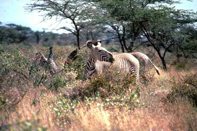 Grevy's Zebra (Equus grevyi) in Buffalo Springs National Reserve, Kenya. (Photograph by Mary Rowen)
 Approximately 80 percent of the remaining 4,500 Grevy’s zebras in the wild are found in the Laikipia-Samburu areas of this ecoregion. Range depletion and scarcity of safe water sources have effectively limited most of the population to the wettest and best-protected southernmost portion of its historic range. The Tsavo area and the Meru and Samburu/Buffalo Springs/Shaba area are high priority areas for antelope conservation. This ecoregion is also important for the reticulated and Masai giraffe (Giraffa camelopardalis subspp. tippelskirchi and reticulata), and the pancake tortoise (Malacochersus tornieri, VU) which is overexploited for the pet trade.
Of most concern amongst the bird species is Hinde’s pied babbler, which has undergone considerable range contraction over the last 100 years. This contraction appears to be primarily the result of its riverine habitat being cleared for cultivation, as well as irrigation schemes and creation of dams along rivers. Curiously, it is increasingly dependent upon an exotic weed, Lantana camara.
Current Status
The ecoregion is reasonably well-protected within a well-functioning system of national parks and other reserves. Protected areas in Kenya include South Turkana and Samburu National Reserves and a number of National Parks: Meru, Kora, Longonot, Ol Donyo Sabuk, Nairobi, Amboseli, Chyulu, Tsavo East and West, and Maralai National Parks. Many of these have a long history of ecological research. In Tanzania, Umba and Mkomazi Game Reserves are in this ecoregion, and in Uganda, Matheniko and Pian Upe Wildlife Reserves are connected by the Bokora corridor. Pian Upe is being considered for National Park status.
These protected areas represent a good cross-section of the ecoregion’s flora and fauna. Many of the larger and/or less-visited areas are subject to varying levels of livestock grazing and bushmeat hunting. In some cases the levels are quite high. These areas may become critical refuges during drought, therefore increased efforts should be made to ensure adequate funding and staffing. In Kenya, there are also numerous private ranches and sanctuaries that support important wildlife populations. These lands, especially those that are near protected areas, are increasingly valuable to the survival of the fauna and flora of this ecoregion.
Despite heavy ivory poaching, fair-sized populations of elephants are still found in three areas within the ecoregion: (1) Amboseli National Park in Kenya (approximately 1,000) and the Kilimanjaro area of Tanzania; (2) Tsavo National Park in Kenya (approximately 7,400); and 3) Mkomazi, Tanzania, and the Laikipia-Samburu area (approximately 3,700) in north-central Kenya. While elephants frequently move outside and between parks and reserves, the majority of their time is spent within the protected area system and wildlife-focused private lands and sanctuaries.
The creation of some of these protected areas has been controversial. The Masai, who formerly grazed their cattle in Amboseli, were excluded from an 80 km2 wildlife viewing area and received no compensation or financial benefits from park entrance fees. In protest, they killed both rhino and elephants and largely as a result of their actions, the number of rhinos in the park decreased from 120 animals to eight. The exclusion from their former grazing lands has influenced the Maasai both socially and economically. It is also thought that the creation of the park may have disrupted a system maintained by pastoralism over thousands of years. The reduced competition from livestock has resulted in marked increases in zebra, wildebeest and elephant. These changes in large mammal assemblages and the concomitant changes in plant assemblages could have complex effects on the population dynamics of predators and other large herbivores.
Types and Severity of Threats
Pastoralists have been an integral part of the ecoregion for thousands of years, and their herds of cattle, sheep, goats, and camels are a significant component of the system. Historically, human use of the area has been limited to pastoralist and hunter-gatherer societies because little of the land is suitable for intensive agriculture, with less than 600 millimeters (mm) rainfall annually. However, unsustainable water use, frequent grassland burning, and overgrazing by domestic livestock have led to habitat fragmentation, increased land degradation, and desertification. Illegal hunting for skins, ivory and rhino horn have severely reduced populations of large animals, particularly elephants and rhinoceros. While much of this illegal hunting has been curtailed, an increasing level of bushmeat hunting threatens many wildlife species. Tourists are also problematic in some of the protected areas of this ecoregion, harassing species of conservation concern such as Grevy’s zebra and cheetah.
Ivory poaching remains a potentially serious threat to the elephants of this ecoregion, although the threat has been temporarily neutralized by the CITES ban. Unfortunately, the demand for rhino horn from Asia and the Middle East persists, and a return to large-scale poaching could be a significant menace. Given the political will, stability and sufficient field expenditure, it is believed that rhinos can be conserved in the wild.
Water is the scarcest resource in the region and the human dominance of standing waterholes and springs as well as the diversion of rivers poses threats to wildlife. Upstream irrigation of the Ewaso Nyiro River, which is heavily used for food and flower production is particularly problematic. Historically, the Ewaso Nyiro flowed year-round (except during severe droughts) through the Buffalo Springs, Samburu, and Shaba reserves. It now frequently dries up during regular dry seasons, thereby limiting the viability of the reserves as dry season refuges for Grevy’s zebras, elephants and giraffes.
The habitats of the ecoregion are moderately fragmented in areas of higher human population (Population growth rate). In drier areas, increasing numbers of domestic livestock combined with a sedentary rather than nomadic form of pastoralism has resulted in range depletion and competition for scarce water sources. In the wetter areas near the coast, threats to the habitat include farming and clearance for large-scale estate agriculture (sisal, cotton, and tobacco). Throughout the ecoregion, cutting of trees for firewood and charcoal production is a major threat to the maintenance of the Acacia-Commiphora bushland and thicket.
Populations of larger mammal species are highly fragmented due to the effects of hunting for meat, poaching of a few species for valuable body parts (elephants and rhinos), and removal of other species which are, or are perceived to be, dangerous to people (lions and African wild dogs). Most of these animals are predominately found in protected areas and in private and community wildlife areas. Poaching for bushmeat is a growing problem, both in areas adjacent to protected areas and in the large areas of common grazing lands. Many groups traditionally have used bushmeat as an important part of their diet. The demand for subsistence bushmeat trade has increased dramatically in recent years, while the resource base is decreasing.
Some plant species, such as the African blackwood (Dalbergia melanoxylon), are also threatened by over-harvesting. These plants are mainly used to make carvings (largely along the coast), for sale to the tourist industry.
Justification of Ecoregion Delineation
This ecoregion forms the central portion of the ‘Somali-Masai Acacia-Commiphora bushland and thicket’ vegetation unit of White. This larger unit was separated into three ecoregions based on different bioclimatic and associated floral and faunal patterns. The ‘East African evergreen bushland and secondary Acacia wooded grassland’ of White was included to better reflect potential vegetation. The ecoregion is bound by the alluvial plains and rocky plateau of the Masai Xeric Grassland and Shrubland ecoregion and the Tana River to the northeast, which represent the extent of some species, such as the common eland (Taurotragus oryx), Bohor reedbuck (Redunca redunca) and Burchell’s zebra (Equus burchelli). To the south it is divided from the Southern Acacia-Commiphora Bushland and Thicket ecoregion roughly by the chain of mountains along the Kenya-Tanzania border. This represents the extent of some species like the gerenuk (Litocranius walleri), which is present in the north, but is absent in much of the south. Additional studies of herbs, birds and plants may help to better define this ecoregion.
Additional information on this ecoregion
- For a shorter summary of this entry, see the WWF WildWorld profile of this ecoregion.
- To see the species that live in this ecoregion, including images and threat levels, see the WWF Wildfinder description of this ecoregion.
- World Wildlife Fund Homepage
Further Reading
- Barnes, R.F.W., and G.C. Craig, H.T. Dublin, G. Overton, W. Simons, C.R. Thouless. 1998. African Elephant Database 1998. Occasional Paper of the IUCN Species Survival Commission No. 22. IUCN, Gland. ISBN: 2831704928
- Brooks, M and R. Emslie. 2000. African Rhino Specialist Group Report. IUCN. Retrieved (2001).
- Burney, D.A. 1996. Paleoecology of humans and their ancestors. Pages 19-36 in T.R. McClanahan and T.P. Young, editors. East African Ecosystems and Their Conservation. Oxford University Press. ISBN: 0195108175
- Collar, N.J. and Stuart, S.N. 1985. Threatened birds of African and related Islands. The ICBP/IUCN Red Data Book, Part 1. Cambridge, UK.
- Emslie, R., M. Brooks. and IUCN/SSC African Rhino Specialist Group. 1999. African Rhino: Status Survey and Conservation Action Plan. Species Survival Commission of IUCN. IUCN, Gland, Switzerland and Cambridge, UK. ISBN: 2831705029
- Hilton-Taylor, C. 2000. The IUCN red list of threatened species. Gland, Switzerland and Cambridge, U.K. ISBN: 2831705649
- IUCN/UNEP 1987. The IUCN Directory of Afrotropical protected areas. IUCN, Gland, Switzerland and Cambridge, UK. ISBN: 2880328047
- Kingdon, J. 1997. The Kingdon field guide to African mammals. Academic Press, London. ISBN: 069111692X
- MacKinnon, J. and K. MacKinnon. 1986. Review of the protected areas system in the Afrotropical realm. Prepared by the IUCN Commission on National Parks and Protected Areas in collaboration with UNEP. IUCN, Gland, Switzerland and Cambridge, UK.
- Maggi, A. 1995. Wild dog sighting in Laikipa, Kenya. Canid News 3: 35.
- Njoroge, P. and L.A. Bennun. 2000. Status and conservation of Hinde’s Babbler Turdoides hindei, a threatened species in an agricultural landscape. Ostrich 71(1 & 2): 69-72.
- Ottichilo, W.K. 1987. The causes of recent heavy elephant mortality in the Tsavo ecosystem, Kenya 1975 – 1980. Biological Conservation 41: 279 – 289.
- Pomeroy, D. and H. Tushabe. 1996. Biodiversity of Karamoja. MUIENR, Kampala, Uganda.
- Stuart, S.N., R.J. Adams and M.D. Jenkins. 1990. Biodiversity in Sub-saharan Africa and its islands: conservation, management and sustainable use. Occasional papers of IUCN/SSC No. 6. IUCN. Gland. ISBN: 2831700213
- TRAFFIC. 2000. Food for thought: the utilization of wild meat in eastern and southern Africa. Retrieved (2001).
- White, F. 1983. The vegetation of Africa, a descriptive memoir to accompany the UNESCO/AETFAT/UNSO Vegetation Map of Africa (3 Plates, Northwestern Africa, Northeastern Africa, and Southern Africa, 1:5,000,000. UNESCO. Paris.
- Woodroffe, R., J.R. Ginsberg, and D.W. Macdonald, editors. 1997. The African wild dog: status survey and conservation action plan. IUCN, Gland, Switzerland. ISBN: 2831704189
| Disclaimer: This article is taken wholly from, or contains information that was originally published by, the World Wildlife Fund. Topic editors and authors for the Encyclopedia of Earth may have edited its content or added new information. The use of information from the World Wildlife Fund should not be construed as support for or endorsement by that organization for any new information added by EoE personnel, or for any editing of the original content. |