Lake Edward
Lake Edward, Africa
| Topics: |
This content is not assigned to a topic
|
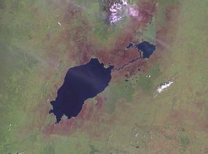
Lake Edward (also known as Lake Rutanzige and formerly as Albert Edward Nyanza) is a major lake in central Africa on the border between Uganda and the Democratic Republic of the Congo (DRC)just south of the equator. It is part of the Nile River system feeding into Lake Albert via the Semliki River.
Geography
Size: 43 miles (70 km) long; 25 miles (40 km) wide;
Area: 830 miles2 (2,150 km2)
Geographic coordinates: The lake extends northwest from approximately 0°4'S 29°23'E to 0°7'S 29°50'E
Location: 150 miles west of Lake Victoria.
Surface altitude: 2,992 feet (912 m)
Maximum Depth: 367 feet (112 m)
The lake receives the inflow of the Kazinga Channel which flows from Lake George 22 miles (36 km) to the northwest. It also recieves inflows four small rivers, the Nyamugasani, Ishasha, Rutshuru and Rwindi rivers.
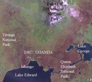
The lake's only outflow is the Semliki River which beginsnear Ishango on the northwestern end within Virunga National Park in the Democratic Republic of the Congo (DRC). The River meanders north and north-northeast, flanked by the Rwenzori Mountains 143 miles (230 km) north across the equator from Lake Edward to Lake Albert.
Lake Edward in bisected by the border between Uganda and the Democratic Republic of the Congo. The north and eastern third of the lake iswithin Uganda while the other two-thirds of the lake, with the entire western and southern shores, are included within the DRC.
Lake Edward lies in the Albertine rift, the western branch of the Great Rift System. On its western side, the high Rwenzori Mountains rise steeply from the lake shore and extend north and south of the lake. This steep terrain continues into the lake and its deepest part is near its western shore under the Rwenzori Mountains. An outcropping of the Rwenzori rises to north of the lake east of the Semliki river valley.
On the eastern side the terrain is a lot less steeper with rolling hills. The south of the lake is flankedby the lowland valley swamps and savannas of the Rwindi, Rutshuru and Ishasha rivers.
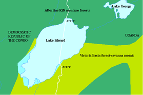
The area around Lake Edward is included within two ecoregions. The western and northern areas are covered by ecologically-rich Albertine Rift montane forests which takes in much of Rwenzori Mountains extending north and south. The Albertine Rift montane forests are famous for their high numbers of endemic species, including the Mountain gorillas which are found south of Lake Edward.
The eastern shore of the lake meets the rolling hills and plateaus of the Victoria Basin forest-savanna mosaic which extends to and around much of Lake Victoria.
The DRC's Virunga National Park takes all of the lake included within the DRC's border as well as the eastern shore of the lake, the forested Semliki valley to the north and lowland valley swamps and savannas of the Rwindi, Rutshuru and Ishasha rivers to the south.
Uganda's Queen Elizabeth National Park includes most of the eastern and northern shore of Lake Edward. The park covers 794 miles2 (2,056 km2) and is recognized for its ecological significance under the UNESCO Man in the Biosphere Programme.
Further Reading:
- Freshwater Ecoregions of Africa and Madagascar: A Conservation Assessment (World Wildlife Fund Ecoregion Assessments) by Michele L. Thieme, Robin Abell, Melanie L. J. S. Stiassny, Paul Skelton, Neil Burgess, Bernhard Lehner, Eric Dinerstein, David Olson, Guy Teugels, and Andre Kamdem-Toham, Island Press, 2005 ISBN: 1559633654.
- Africa by John Reader, National Geographic Society, 2001 ISBN: 0792276817.
- Merriam-Webster's Geographical Dictionary, Third Edition, 2007 ISBN: 0877795460.
- Uganda by Philip Briggs, Bradt Travel Guides; 5th edition, 2007 ISBN: 184162182X.
See Major rivers, lakes, mountains, and other terrestrial features of Uganda and Uganda country profile


