UKhahlamba/Drakensberg Park, South Africa
| Topics: |
Contents
- 1 Introduction
- 2 Geographical Location
- 3 Date and History of Establishment
- 4 Area
- 5 Land Tenure
- 6 Altitude
- 7 Physical Features
- 8 Climate
- 9 Vegetation
- 10 Fauna
- 11 Cultural Heritage
- 12 Local Human Population
- 13 Visitors and Visitor Facilities
- 14 Scientific Research and Facilities
- 15 Conservation Value
- 16 Conservation Management
- 17 IUCN Management Category
- 18 Further Reading
Introduction
The Ukhahlamba-Drakensberg Park (28°55' to 29°55' S and 29°05' to 29°45'E), a World Heritage Site, is a mountain range of spectacular natural beauty which is a major center of endemism and has a great diversity of birdlife and plants. Its ramparts of golden sandstone and soaring basalt buttresses rise above pristine steep-sided river valleys, rocky gorges and high rolling grasslands. It also harbors in hundreds of caves and rock shelters the largest concentration of early rock art in Africa south of the Sahara made over a period of 4,000 years by the San people. These are outstanding in their quality and diversity of subject and their depiction of animals and human beings and of the spiritual life of the San people who no longer live in the region.
Geographical Location
The Drakensberg or uKhahlamba Park is part of a 200 kilometers (km) long crescent-shaped island mountain range in Kwazulu-Natal Province along its western border with Lesotho. It lies between 28°55' to 29°55' S and 29°05' to 29°45'E, with a northern outlier, Royal Natal National Park, between 28°38' to 28°46' S and 28°52' to 29°00' E.
Date and History of Establishment
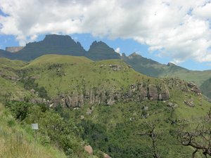 Drakensberg Mountain. (Source: Virginia Tech University)
 The Park comprises 12 protected areas established under 4 different designations between 1903 and 1973: one National Park: four Nature Reserves: six State Forests: and one Game Reserve.
- 1903: A game reserve near Giant’s Castle established by Government Notice 735;
- 1905: The area declared a Demarcated Forest; 1907: Proclaimed a Game Reserve by Government Notice 356;
- 1916: The Natal National Park formally established by the Provincial administration;
- 1922: The first forest reserve in the region proclaimed (Cathkin Forest Reserve);
- 1927-51: State Forests were demarcated to ensure the protection of water-producing areas;
- 1947: The northern section renamed Royal Natal National Park after a royal family visit;
- 1951: Kamberg Nature Reserve proclaimed under the Nature Conservation Ordinance;
- 1953: Loteni Nature Reserve proclaimed under the ordinance;
- 1967: Vergelegen Nature Reserve proclaimed under the ordinance;
- 1973: Mdedelelo and Mkhomazi areas within State Forests proclaimed Wilderness Areas;
- 1979: Mzimkulu and Mlambonja areas within State Forests proclaimed Wilderness Areas;
- 1992: All State Forest areas in the Drakensberg assigned to the Natal Provincial Administration;
- 1993: Control of all protected areas in the Drakensberg assigned to the Natal Parks Board;
- 1993: The uKhahlamba / Drakensberg Park established;
- 1997: Inscribed on the list of Wetlands of International Importance under the Ramsar Convention;
- 1998: The Natal Parks Board and Kwazulu Department of Nature Conservation were amalgamated in the Kwazulu-Natal Nature Conservation Service (KNNCS).
Area
The total area of the Park is 242,813ha. It comprises the following protected areas:
- Royal Natal National Park 8,094 ha
- Mkhomazi State Forest 49,156 ha
- Loteni Nature Reserve 3,984 ha
- Cathedral Peak State Forest 32,246 ha
- Kamberg Nature Reserve 2,980 ha
- Garden Castle State Forest 30,766 ha
- Vergelegen Nature Reserve 1,159 ha
- Cobham State Forest 30,498 ha
- Rugged Glen Nature Reserve 762 ha
- Highmoor State Forest 28,151 ha
- Giant’s Castle Game Reserve 34,638 ha
- Monk’s Cowl Sate Forest 20,379 ha
Within State Forest areas:
- Mdedelelo Wilderness Area 27,000 ha
- Mkhomazi Wilderness Area 56,155 ha
- Mzimkulu Wilderness Area 28,340 ha
- Mlambonja Wilderness Area 6,270 ha
Land Tenure
State owned. Administered by the KwaZulu-Natal Nature Conservation Service.
Altitude
1,280 meters (m) to 3,446 m (Mafadi).
Physical Features
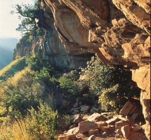 uKhahlamba / Drakensberg Park. (Source: UNESCO)
 The Drakensberg Mountains which reach from Cape Province to eastern Transvaal are the towering outer rim of the Great Escarpment of the interior plateau. The rugged topography has a great variety of summits, peaks and plateaus, basalt-capped sandstone cliffs, basalt buttresses and deep valleys between high spurs. In Natal the range divides into two distinct regions: the main basalt and sandstone escarpment rising to more than 3,400 m above sea level, and the foothill escarpment or Little Berg of steep-sided spurs, terraces and valleys below 2,000 m. The Park's upper boundary follows the border with Lesotho where the western half of the range is called the Maluti Highlands.
The Drakensberg consists of a number of horizontally bedded geological strata forming steps. The thick sedimentary succession is capped by an accumulation of basaltic lava, comprising the upper part of the Karoo Supergroup which has a composite thickness of up to 7,000 m in this area. It is comparable to the Simen Massif in Ethiopia in its igneous basalts that have been eroded to form precipitous cliffs and deep valleys. The underlying sedimentary rocks accumulated in pulses of sedimentation in a depositional basin that developed in response to compressional tectonics in the Cape Fold belt, to the south and south-east, which was the area of provenance for much of the Karoo Supergroup.
The most distinctive physiographic features of the Drakensberg foothills are the high cliffs formed of cream to maroon fine-grained sandstone of the Clarens Formation and the high basalt cliffs which in the Amphitheatre form a massive crescent over 600 m high and 5 km long. The sandstone succession is up to 150 m thick, accumulated as desert dunes and wadi systems during the arid Late Jurassic period. Thinly-bedded lacustrine and interdune sediments preserve footprints of quadrupedal and bipedal dinosaurs which are exposed in the roofs of caves and overhangs in some areas. Large blocks of massive sandstone litter the slopes below the cliffs. Hundreds of caves or overhangs are present which were once inhabited by the San people and preserve their rock-art.
The environmental heterogeneity of the Great Escarpment region are due to its range of altitudes, to temperature extremes and high rainfall, a varied geology and the associated acidic lithosols, its geomorphological diversity and a concentration of high altitude mountain wetlands: springs, tarns, bogs, marshes and streams. The Park contains landscapes and features of exceptional natural beauty. Notable are the barrier of high jagged peaks and intervening spurs, the escarpment walls of dark basalt above the light colored Clarens sandstone, the pristine steep-sided river valleys and rocky gorges containing patches of forest, thickets and grasslands, waterfalls, cascades and rock pools, the rolling high-altitude grasslands with their contrasting seasonal colors, the displays of spring flowers, and the view from the top of the mountains across the vast distances of the grasslands of Kwazulu-Natal. Ten rivers or major streams originate in the Park including the Boesman's, Mkhomaasi and Mzimkhulu rivers and tributaries of the Tugela. The Park which backs onto the headwaters in Lesotho of the Orange river is one of the country's major water catchments.
Climate
The climate of the region is dominated by the influence of subtropical anticyclones and the Drakensberg is one of the best watered, least drought-prone areas of southern Africa. In winter, the subsidence of cold air causes atmospheric stability and a distinct dry season. In summer, the subsidence inversion may rise above the escarpment resulting in an influx of humid air from the Indian Ocean in south-easterly winds. Precipitation is often in the form of thunderstorms. The annual precipitation is between ~1,000 and 2,000 millimeters (mm) on the escarpment, precipitation between November to March accounting for 70% of the annual total with the winter months accounting for less than 10%.
The mean annual temperature of the Drakensberg is about 16°C, but both seasonal and diurnal variations are considerable. The highest temperatures (up to 35°C) occur during summer on north-facing slopes at lower latitudes, while the lowest temperatures (down to about -20°C) occur during winter nights on the summit plateau. Frost is common in winter with about 180 days between mid April and October at higher elevations, but the local topography controls its distribution and intensity. It also occurs lower down when cold air from the high plateaus drains into lower-lying valleys.
Vegetation
The vegetation reflects the effects of climate and fire and the variety of the topography, elevation, geology, soils, slopes and drainage. It is largely grassland and occurs in three main belts: the river valleys, the spurs and the summit plateau which is an island of Afro-alpine flora. These form the low altitude valley belt (1,280-1,830 m) with Podocarpus latifolius forest in sheltered areas, the mid altitude belt (1,830-2,865 m) with Passerina-Phillipia-Widdringtonia fynbos with Protea parkland on spurs and the high altitude belt of Afro-alpine tundra (2,865-3,480 m) with Erica-Helichrysum climax heath. The grassland is a dense sour Alti-grassland. The vegetation of the high-altitude wetlands is almost unique and supports 36 endemics and a high diversity of restricted species.
2,153 species of plants have been described in the Park, including 1,993 species of angiosperms, 5 gymnosperms, 70 ferns and 85 mosses. The two outstanding features of the representation of families in the southern Drakensberg flora are the high percentages of Compositae (285 species) and of monocotyledons (five families), which together comprise over 55% of the flora. Among these, 109 are internationally threatened and 109 also nationally threatened. There is a large number of endemic species. Of the 394 species recorded for the Drakensberg Alpine Region, at least 247 species occur in the Park of which some 98 species (51.5%) are endemic or near-endemic. The percentage of endemism of the whole flora is 29.5%.
Fauna
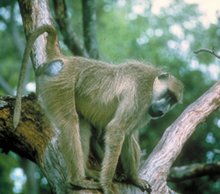 Yellow baboon, Papio cynocephalus. (Source: University of Wiscosin-Madison)
 The fauna includes a total of 48 mammals, 299 birds, 48 reptiles, 26 amphibians and 8 species of fish. The 48 mammal species include Chacma baboon Papio cynocephalus ursinus, 5 species of carnivora including the blackbacked jackal Canis mesomelas, ardwolf Proteles cristatus and serval Felis serval, 11 species of artiodactyla and 16 species of rodentia, 11 of which last are endemic to South Africa. The largest populations of the clawless otterAonyx capensisand spotted-necked otterLutra maculicollis (VU)in KwaZulu-Natal, and possibly South Africa, occur within the Park. Large populations of several antelopes are present and include an estimated population of 1,500-2,000 of the endemic grey rhebok Pelea capreolus, 1,000 reedbuck Redunca arundinum, and approximately 2,000 eland Taurotragus oryx; also bushbuck Tragelaphus scriptus, blue duiker Cephalophus monticola , klipspringer Oreotragus oreotragus and oribi Ourebia ourebi. The Park is the only protected area in Kwazulu-Natal known to have populations of Sclater's golden mole Chlorotalpa sclateri (VU), Cape mole rat Georychus capensis, ice rat Otomys sloggetti and the small grey mongoose Galerella pulverulentus. There are no mammals included on the international list of threatened species, but 11 species are listed in the Red Data Book for South Africa and seven are listed under CITES Appendices I or II.
A total of 296 species have been recorded, 37% of the non-marine bird fauna of South Africa. 10 species are internationally threatened and 18 are listed in the Red Book for South Africa. 43 species are endemic, among them species of restricted range such as the whitewinged flufftail or crake Sarothrura ayresi (EN), ground woodpecker Geocolaptes olivaceus, Rudd's lark Heteromirafra ruddi (CR), buffstreaked chat Saxicola bifasciata, Cape rock thrush Monticola rupestris, sentinel rock thrush Monticola explorator, black bushcap Lioptilus nigricapillus, Drakensberg prinia Prinia hypoxantha, Gurney's sugarbird Promerops gurneyi, and the high altitude species yellowbreasted pipit Anthus chloris (VU), mountain pipit Anthus hoeschi, orangebreasted rockjumper Chaetops auranticus, and Drakensberg siskin Serinus symonsi.Also recorded are black-headed heron Ardea melanocephala, white stork Ciconia ciconia, black stork Ciconia nigra, southern bald ibis Geronticus calvus (VU), Cape vulture Gyps coprotheres (VU), lammergeyer Gypaetus barbatus, black harrier Circus maurus, lesser kestrel Falco naumanni (VU), corncrake Crex crex (VU), wattled crane Grus carunculata (VU), and blue crane Grus paradisea (VU).
Seven species of fish have been recorded, including two introduced alien species of salmonidae and the rare endemic Drakensberg minnow Oreodaimon zuathlambae. The Park contains 26 species and subspecies of frogs which is 21% of the national total of 124. Rare species include the longtoed tree frog Leptopelus xenodactylus and Hewitt's ghost frog Heliophryne hewitti. Of particular interest are several species limited to the very high altitudes and low [[temperature]s]: water rana Rana vertebralis, Lesotho river frog R.dracomantana (VU), Drakensberg stream frog Strongylopus hymenopus (VU), Drakensberg toad Bufo gariepensis nubicolus (VU) and dwarf dainty frog Cacosternum nanum parvum (VU). There are 23 lizard species including the water monitor Varanus niloticus and three endemic species: Lang's crag lizard Pseudocordylus langi, Tropdosaura cottrelli and T.essexi, also 25 species of snakes, one endemic: the cream-spotted mountain snake Montaspis gilvomaculata.
The invertebrate fauna of the park is less well known but includes many species endemic to the region. These include for example 21 species of millipedes, and 32 species of craneflies. Of the 156 South African species of dragonflies, 44 have been found in the Park, one being endemic, and 74 butterfly species which is 11.7% of the butterflies found in the country.
Cultural Heritage
The Drakensberg region ranks as one of the most important archaeological areas in South Africa. Archaeological sites from the Early, Middle and Late Stone Ages and the Late Iron Age are present, indicating that this region may have been occupied by man over the last million years. The first evidence of human occupation of the Park area dates from the Middle Stone Age, 20,000 years ago, but it was the Late Stone Age San people who inhabited the area from about 8,000 years ago. The population was small, probably never more than a thousand in the Park, and therefore had little significant impact on the vegetation or wildlife population of the area. These Bushmen were hunter-gatherers and often lived in caves and rock shelters, now adorned with thousands of rock paintings dating from 2-3000 years ago up to the 19th century when they were added to by Bantu settlers. Several caves containing important San rock art were declared national monuments by the National Monuments Act, namely Battle Cave, Main Caves, Game Pass 1 and Kanti 1.
The settlement of Iron Age farmers in the foothill areas east of the main escarpment may possibly date from the 1200s, or earlier. These people brought cattle and sheep into the region. However by the late 1600s there were African cattle-herding people living in permanent settlements in areas adjacent to the northern and central Drakensberg region. The people living in the area to the north were known as the Zizi and to the south, the Tholo. Relations between these people and the San were complex during the nineteenth century. From 1816, under the leadership of Shaka, the rise of Zulu military power in Zululand far to the north-east brought an end to peace in the region as successive waves of refugees displaced by the Zulu army (impis) settled towards the Drakensberg, in turn attacking those already there. They named the [[mountain]s] the Barrier of Spears, uKhahlamba.
The white settlers (voortrekkers) arrived in late 1837. Many turned to livestock farming and hunted down the wild game. This brought them into conflict with the native hunter-gatherer people of the area who were partly dependent on hunting. These then raided the livestock and the Natal colonial authorities organized their containment and pursuit. By 1871 the last of the Lesotho San were destroyed and from then on were no longer found in the Drakensberg as a viable community.
Local Human Population
In the north the protected area is divided by the Mnweni Tribal Area, who may begin running ecotourism programs there compatible with the Park. No private persons occupy the Park itself except staff employed by the KNNCS. The use of the Park by the San and Iron Age agriculturists probably contributed to the diversity of habitat types in some areas. The nature-based tourism plan is based on the principles of integrated environmental management, and is designed to provide appropriate and sustainable access to resources within the Park, while ensuring the protection of the most fragile and the equitable distribution of benefits to local communities in the region.
Visitors and Visitor Facilities
Ecotourism is recognized as one of the Park's most attractive development options because of the sustainable character of nature conservation as a land use in sensitive natural environments. Ecotourism and nature conservation are seen to be a labor intensive industry with the potential to provide employment and other benefits to neighboring impoverished rural communities.
There are 15 entrance gates to the Park. Members of the public enter either as day or overnight visitors using caravan and camping areas, caves and mountain huts. The Park can currently accommodate 2,000 people per night in ten centers. Tendele in Royal Natal National Park and Giant's Castle both have lodges and multi-person chalets. In addition, almost 2,200 beds are provided by nearby private enterprise outside the Park. The number of visitors has ranged between 224,000 (1994-95) to 288,200 (1996-97). Activities permitted are: day-walks and overnight hiking, the use of chalets and mountain huts, camping and caravaning, game and plant viewing, bird-watching, mountaineering, rock and ice climbing, paragliding, education, interpretation, recreation and religious worship. Access to the recreational opportunities of the Park is provided by the Nature Conservation Service and private operators by vehicles and horses via wilderness trails, guided walks, and day and overnight hiking.
Scientific Research and Facilities
There is a research station at Cathedral Peak run by the Council for Scientific and Industrial Research. A large number and wide range of projects have been researched over the past 25 years, and a high level of monitoring continues. Knowledge of many taxonomic groups in the Park is poor, particularly of the lower plant and invertebrate groups. Palynological studies on wetland deposits in areas surrounding the Drakensberg have yielded evidence of significant change in plant communities in response to cyclic climate change during the Quaternary period. The Late Pleistocene Hypothermal resulted in a regional desiccation and lowering of [[temperature]s] by up to 6° which led to a spread of components of the fynbos vegetation typical of high altitudes to distant river valley areas as much as 900 m lower. The effect of vegetation change on faunal populations during these climatic changes has been documented from fossil evidence at numerous sites around the Drakensberg area. Archaeological research and particularly research into the rock art has been undertaken by several archaeologists in the last few decades. The history of this research is compiled in Mazel (1989).
Conservation Value
The Park is located within the Drakensberg alpine region, one of the world's oldest centers of endemism and an outstanding center of plant diversity. Endemic plant species number 394 for the region and 247 for the Park. It contains a diversity of [[habitat]s] from mountain peaks and summit plateaus which include the unique alpine tundra and Erica-Helichrysum heath through steep mid-altitude slopes supporting a wide variety of fynbos scrub, grassland and woodland communities to lower lying valleys containing various types of grassland and forest. The species richness results from the Park's subcontinental position on the complex interface between Cape and subtropical biota; also in the past speciation events within the Drakensberg center of endemism (Vavilov center), the impact of major past erosion and uplift events, many successful dispersal and establishment events, and the resultant wide diversity of habitats. The mountain region round the Park is ancient, has played an important role in the distribution of ancient invertebrate lineages and been a refuge for some relict palaeogenic taxa, particularly invertebrate groups.
Conservation Management
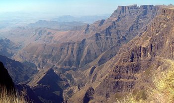 On the Ridge of the Amphitheatre, Drakensberg (Royal Natal National Park, KwaZulu-Natal, South Africa). (Source: Wikimedia Commons)
 The laws that establish the Drakensberg Park as a conservation unit are the KwaZulu-Natal Nature Conservation Management Act 9 of 1997 as amended and the Republic of South Africa National Forest Act 84 of 1998. All components of the Park are defined as protected areas by this legislation and listed in a schedule in the act. The control and management of State Forests proclaimed under the National Forest Act 84 of 1998 lies with the Minister of Water Affairs and Forestry. The KNNCS is seeking re-assignment of the control and management for the State Forest components of the Park. Other legislation under which the Park is protected are: The Water Act 54 of 1956 as amended, the National Water Act 36 of 1998, the National Monuments Act 28 of 1969, the Environment Conservation Act 73 of 1989 as amended, the KwaZulu-Natal Heritage Act 10 of 1997, and the National Environmental Management Act 107 of 1998.
The management of the Park is delegated by the Provincial Administration to the KwaZulu-Natal Nature Conservation Service. Plans for component areas of the park have been revised, adopted or are nearly complete. Drakensberg is one of the Special Case Areas, where restrictions on development are applied to preserve those features which make the region a special area. The first phase of a study has been completed documenting the unique and sensitive nature of the environment of the Drakensberg and recognizing the need for a planning framework to co-ordinate appropriate sustainable development. The framework was based on the boundaries of the area, sub-regions and zones in which preferred, prohibited or non-preferred land uses have been identified. The study has drawn on the provisions of the UNESCO Seville Strategy for the statutory requirements for the designation of Biosphere Reserves.
The Park is part of the Drakensberg-Maluti Transfrontier Conservation and Development Area, established in June 2001 by the National Environment Secretariat of Lesotho and the KwaZulu-Natal Nature Conservation Service with the help of the Global Environment Facility and the World Bank. It totals 8,113 square kilometers (km2) in area, 5170 km2 in Lesotho which includes over 80% of the Afro-alpine zone of southern Africa, and 2,943 km2 (36.3%) in South Africa. The enabling Giant's Castle Declaration endorsed the concept of a protected area embracing the Lesotho Maluti Highlands and the KwaZulu-Natal Drakensberg Mountains and recognized the importance of formally declaring a core Transfrontier Peace Park linking the Sehlabathebe National Park in Lesotho with the southern end of the Drakensberg Park.
The KwaZulu-Natal Nature Conservation Service has instituted a comprehensive community conservation program for the whole Park. Partnership forums with all communities and interest groups have been established. An integrated conservation and development program known as the Partners in Mountain Conservation program has been running for several years. Sustainable use of certain products is permitted. These include harvesting of various grass and sedge species for construction of buildings, thatching and handicrafts, the collection of seeds of medicinal plants, removal of certain surplus herbivores (Herbivory) for translocation to other conservation areas or private game ranches, collection of biological material for scientific research, fishing, fly fishing for trout in dams and rivers and the removal of timber of alien species for fuelwood.
Management Constraints
Threats to the integrity of the Park are related to land claims within certain areas of the park and invasive alien plants. In addition, tourism developments have impacted trails in the vulnerable alpine areas, caves and the rock art. It is estimated that the total area of the Park transformed by both alien plant infestation and infrastructural developments is approximately 1.4% (3,452 ha).
Alien invasive plants are considered the most serious threat to the ecological integrity of the Park, but the area currently affected by such invasions is limited. The principal threats are posed by black wattle Acacia mearnsi, silver wattle A. dealbata, patula pine Pinus patula, American bramble Rubus cuneifolus, grey poplar Populus canescens and Cotoneaster spp. As part of the South African Working for Water campaign, areas within the mountain catchments of the Drakensberg have been cleared, or are in the process of being cleared of major infestations of alien tree species. Programs of controlled burning are also part of the routine maintenance. At lower elevations overgrazing pressure round the Park is heavy and from time to time there are requests from local communities to graze domestic stock inside the Park or to establish water supply schemes and from developers wishing to establish resorts. For claims to the land in the Park to be successful claimants must prove prior ownership or occupation. The authorities, after considering the desirability of restoring the land, would have to find in favor of the claimants where claims are proven.
There are several threats to the rock art of the Drakensberg. The main causes of deterioration in rock painting are natural weathering of the rock and paint, and vandalism. The principal threat is the irreversible and ongoing process of the weathering that created the rock shelters in the first place. Research is being conducted on weathering to determine ways to reduce, if not eliminate, natural threats to the art. In addition, campers light fires in painted rock shelters, and the smoke blackens the walls and ceilings, and people often wet the paintings to bring out the colors, sometimes using carbonated soft drinks that have an even more destructive effect. The risk of these human activities has been reduced in the Drakensberg region: the location of most painted sites does not now appear on maps available to the public; access to the entire region and camping in painted caves is strictly controlled and a few sites have been fenced (Main Caves, Game Pass and Battle Cave). However, access to them is permitted in the company of a guide. In addition, a rock art interpretative center has been planned.
As the Drakensberg is prone to heavy winter snowfalls, and summer [[rainfall]s] may result in flooding in valleys and landslides on the mountain slopes, a mountain rescue service is in place.
Staff
All major decisions are taken by the KwaZulu-Natal Nature Conservation Board.The Park is administered by a Chief Conservator and a staff of 604 permanent and part-time employees in three divisions; conservation (with four sub-directorates), scientific services (with three sub-directorates) and administration (with three sub-directorates). There are three administrative centers: at Royal Natal National Park in the northern region of the Park with five management offices, at Giant's Castle Game Reserve in the central region with six management offices, and in the southern region at Himeville outside the Park, with four management offices within the Park.
In addition to conservation, staff are employed to undertake support functions such as construction, planning, public relations, secretariat services, accounting and accommodation bookings. Staff stationed within reserves are responsible for implementing wildlife management programs, for the management of visitor facilities and the provision of environmental awareness programs, or for undertaking research and monitoring projects.
Budget
The KwaZulu-Natal Nature Conservation Service is a semi-autonomous and non-profit making organization, funded by the KwaZulu-Natal Provincial Legislature (60% of total funding). It earned R131, 613, 712 during 1998/99 financial year.
IUCN Management Category
- Category I (48%) and II (51.5%)Ramsar site.
- Natural and Cultural World Heritage Site: Natural Criteria iii, iv. Cultural Criteria i, iii
- Inscribed on the World Heritage list in 2000
Further Reading
- Bowie, R. & Frank, A. (2001). Drakensberg Alti-Montane Grasslands and Woodlands. WWF Report.
- Branch, W. (1998). Field Guide to Snakes and Other Reptiles of Southern Africa. Struik, Cape Town. ISBN: 0883590425.
- Cowling, R., Richardson, D. & Pierce, S. (1997). Vegetation of South Africa. Cambridge University Press, Cambridge, United Kingdom. ISBN: 0521571421.
- Dely, J.,Kotze, D.,Quinn, N. & Marder, J. (1995). A Pilot Project to Compile an Inventory and Classification of Wetlands in the Natal Drakensberg Park. Report No.101, Institute of Natural Resources, Pietermaritzburg.
- Dowsett, R. (1986). Origins of the high-altitude avifaunas of tropical Africa. in Vuilleumier, F. & Monasterio, M., (eds). High Altitude Tropical Biogeography. Oxford University Press, New York. Pp 557-585. ISBN: 0195036255.
- Fishpool, L.& Evans,M.(eds) (2001). Important Bird Areas for Africa and Associated Islands.Priority Sites for Conservation. Pisces Publications and Birdlife International, Newbury and Cambridge, U.K. BLI Conservation Series No.11. ISBN: 187435720X.
- Hedberg, O. (1986). Origins of the Afroalpine flora. in Vuilleumier, F. & Monasterio, M. (eds). High Altitude Tropical Biogeography. Oxford University Press, New York. Pp 443-465. ISBN: 0195036255.
- Hilliard, O. & Burtt, B. (1987). The Botany of the Southern Natal Drakensberg. National Botanical Gardens, Pretoria. CTP Book Printers, Cape Town. ISBN: 0620106255.
- Hilton-Taylor, C.(1996). Red Data List of Southern African Plants. National Botanical Institute, Pretoria. Strelitzia 4.
- Hilton-Taylor, C. (2000). 2000 IUCN Red List of Threatened Species. IUCN, Gland, Switzerland & Cambridge, United Kingdom. ISBN: 2831705657.
- Irwin, D & Irwin P. (1992). A Field Guide to the Natal Drakensberg. The Natal Witness, Pietermaritzburg.
- Killick, D. (1990). Field Guide to the Flora of the Natal Drakensberg. Jonathan Ball & Ad Donker Publishers. Johanesburg. ISBN: 0947464352.
- Killick, D. (1994). Drakensberg alpine region. In Davis, S. & Heywood, V. 1994. Centres of Plant Diversity: a Guide and Strategy for Their Conservation. Oxford University Press, Oxford. ISBN: 283170197X.
- Killick, D. (1997). Alpine tundra of southern Africa. In Wielgolaski, F.(ed.). Ecosystems of the World 3: Polar and Alpine Tundra. Elsevier, Amsterdam. ISBN: 0444882650.
- KwaZulu-Natal Nature Conservation Service (1999). Nomination Proposal for the Drakensberg Park Alternatively Known as Okhahlamba Park to be Listed as a World Heritage Site. Department of Environmental Affairs & Tourism, South Africa.
- Lewis-Williams, J. & Dowson, T. (1992). Rock Paintings of the Natal Drakensberg. University of Natal Press, Pietermarirzburg. /?tag=encycofearth-20 ISBN:.
- Little, R. & Bainbridge, W. (1992). Birds of the Drakensberg Park. Wildlife Society of Southern Africa, Durban.
- Low, A. & Rebelo, A. (1998). Vegetation of South Africa, Lesotho and Swaziland. Department of Environmental Affairs and Tourism, Pretoria. 2nd
- Mazel, A. (1989). People making history: the last ten thousand years of hunter-gatherers communities in the Thukela basin. Natal Museum J. Humanities. 1: 1-168.
- Passmore, N. & Carruthers,V. (1995). South African Frogs: a Complete Guide. Witwatersrand University Press, Johannesburg. ISBN: 1868125173.
- Rowe-Rowe, D. (1994). The Ungulates of Natal. Natal Parks Board, Pietermaritzburg.
- Stuart, C. & Stuart, T. (1995). Field Guide to the Mammals of Southern Africa. Struik, Cape Town. ISBN: 177007404X.
- Ward, V. (1997). A Century of Change: Rock deterioration in the Natal Drakensberg, South Africa. Natal Mus. J. Humanities 9: 75-97.
- Wright, J. (1971). Bushman Raiders of the Drakensberg. University of Natal Press, Pietermaritzburg.
| Disclaimer: This article is taken wholly from, or contains information that was originally published by, the United Nations Environment Programme-World Conservation Monitoring Centre (UNEP-WCMC). Topic editors and authors for the Encyclopedia of Earth may have edited its content or added new information. The use of information from the United Nations Environment Programme-World Conservation Monitoring Centre (UNEP-WCMC) should not be construed as support for or endorsement by that organization for any new information added by EoE personnel, or for any editing of the original content. |
1 Comment
Peter Howard wrote: 01-27-2011 22:51:47
Readers may want to visit the African Natural Heritage website to view a selection of images and map of the uKhahlamba/Drakensberg Park world heritage site, and follow links to Google Earth and other relevant web resources: http://www.africannaturalheritage.org/Drakensberg-South-Africa.html