Tropical Rainforest Heritage of Sumatra, Indonesia
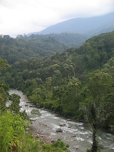
Agusan River and Gunung Leuser National Park. Source: Erwin Adriawan Perbatakusuma
The Tropical Rainforest Heritage od Sumtra, Indonesia is a serial World Heritage Site that comprises three widely separated nationally protected areas along the Bukit Barisan mountain range, which runs along the western side of the island of Sumatra.
The sites are:
- Gunung Leuser National Park (2°53'-3°50'N x 96°45'-97°35'E) in the northern provinces of Nanggroe Aceh Darussalam and Sumatra Utara;
- Kerinci Sablat National Park (1°7'13"-3°26'14"S x 100°31'18"-102°44'1"E) in the south-central provinces of Sumatra Barat, Jambi, Sumatra Selatan and Benkulu; and,
- Bukit Barisan Selatan National Park (4°29'-5°57'S x103°24'-104°44'E) in the far southern provinces of Sumatra Selatan, Bengkulu and Lampung, partly bordering the southwest coast.

Contents
- 1 Dates and History of Establishment
- 2 Areas
- 3 Land Tenure
- 4 Altitude
- 5 Physical Features
- 6 Climate
- 7 Vegetation
- 8 Fauna
- 9 Cultural Heritage
- 10 Local Human Population
- 11 Visitors and Visitor Facilities
- 12 Scientific Research and Facilities
- 13 Conservation Value
- 14 Conservation Management
- 15 Tropical Rainforest Heritage of Sumatra
- 16 Further reading
Dates and History of Establishment
- 1914: The Acehnese requested protection of forests in Aceh province;{| align="right"
|
 Bukit Barisan Selatan National Park, Indonesia. (Source: Departemen Kehutanan Republik Indonesia)
|}
- 1934: Gunung Leuser Wildlife Reserve established (416,500 hectares (ha)); 1936 and 1938: area enlarged;
- 1972,1973: Two private orangutan rehabilitation and research stations set up;1976: area again enlarged;
- 1980: Gunung Leuser National Park established by Forestry decree # 719 DJ/VI;
- 1984: Final additions made to Gunung Leuser Park.
- 1921: Kerinci Sablat National Park area: 3 forests created Nature Reserves, and 3 given limited protection status (270,637 ha);
- 1929,1936: Five forests given Nature Reserve status;
- 1979: Three forests given Wildlife Reserve status;
- 1982: National Park status extended to a total of 17 gazetted and proposed reserves and forests;
- 1992: Kerinci Sablat National Park established by Ministry of Forestry decree #1049/Kpts II; amended by decrees # 192/Kpts II in 1996 and by # 991/Kpts in 1999;
- 1999: KSNP officially gazetted.
- 1935: Bukit Barisan Selatan area: a Wildlife Reserve set up; 1979: proclaimed a Nature Reserve;
- 1982: BBSNP established by Ministry of Agriculture decree #736/MENTAN/X, and in 1982 by Ministry of Forestry decree # 096/Kpts II;
- 1990: BBSNP Marine Reserve (21,600 ha) established by Ministry of Forestry decree #71/Kpts II;
- 1990: Management plans required from Parks under law UURI #5 on biological reserve conservation.
Areas
Total area of this serial site is 2,595,124 ha, comprising the following protected areas:
- Gunung Leuser National Park (GLNP): 862,975 ha
- Kerinci Sablat National Park (KSNP): 1,375,349.867 ha
- Bukit Barisan Selatan National Park (BBSNP): 356,800 ha
Land Tenure
State. Administered by the Directorate General of Forest Production and Forest Conservation in the national Ministry of Forestry through separate managements for each Park. The European Union (EU) sponsored Leuser Ecosystem of protected areas adjacent to GLNP will be managed by the Leuser International Foundation from 2004 onwards.
Altitude
Sea level to 3,805 meters (m) (the summit of Gunung [Mount] Kerinci).
Physical Features
The proposed composite site of the Tropical Rainforest Heritage of Sumatra, Indonesia's third largest island, straddles the equator along the north, center and south of the Bukit Barisan mountain range. This runs 1,650 kilometers (km) down the western side of the island studded with active volcanoes, with a rift valley to the east which almost divides the Parks. Geologically the range and valley result from the down-thrusting of the Austro-Indian tectonic plate under the Asian plate. The eastern side of Sumatra is predominantly lowland and in the past has periodically been linked to the Asian mainland.
Gunung Leuser National Park in the north is 150 km long, over 100 km wide and is predominantly mountainous. It covers most of the West Barisan, West Alas and East Barisan ranges and is nearly divided by the Alas valley graben. 40% of the Park, mainly in the north, is steep and over 1,500 m; 12% of the Park only, in the lower southern half, is below 600 m but for 25 km runs along the coast. Eleven peaks are over 2,700 m and the highest point is 3,466 m.
Kerinci Sablat National Park in the center extends 350 km down the spine of the Bukit Barisan, averaging 45 km wide and 2,000 m above sea level. The northern half includes a lower eastern mountain range 800-1,500 m high, nearly cut off by the 15 km wide Sungai Penuh valley graben and is about 75 km wide. Three quarters of the park is steep. Its highest point is the magnificent Gunung Kerinci at 3,805 m, the highest peak in Sumatra and highest volcano in Indonesia. It is active. Nearby Gunung Tujuh is an outstandingly beautiful crater lake at 1,996 m.
Bukit Barisan Selatan National Park is also 350 km long but only 45 km wide on average. The northern two-thirds are mountainous, averaging 1,500 m with a highpoint at Gunung Pulung of 1,964 m. The southern half is lower; 90 km of it is a peninsula and the Park borders the sea for half its length. Dozens of rivers originate in the Parks and there are several lakes and hot springs.
The Bukit Barisan range is composed largely of sedimentary rocks uplifted at the same time as the Himalayas about 70 million years ago: limestone, shale, schist, sandstone, quartzite and breccias. Relatively recent magmatic activity associated with tectonic movement created volcanoes still active today; the most devastating of which, 75,000 years ago, being the eruption of Gunung Toba just south of Gunung Leuser. Three million years ago a period of faulting also created the central rift valley (Semangko zone) which parallels the Bukit Barisan on the east. Many soil types in the humid climate result from these rocks, especially in GLNP where brown and red-yellow podsols with lithosols and latosols predominate. In KSNP there are three main soils: podsols, erodable and infertile, are dominant, latosols in the lowlands are somewhat more fertile, and in the volcanic uplands, moderately to highly fertile andosols are common. Most of BBSNP has easily eroded rather infertile podsols.
Climate
The [[mountain]s] have year-round little varying high temperatures, high [[humid]ity] and high rainfall for 9 months in wetter areas, 7 months in drier areas. This climate has encouraged the high speciation and diversity of species. GLNP has a 3,000 millimeters (mm) rainfall in the north to 4,657 mm in the lowland south. Temperatures average between 21° to 28° Celsius (C) and the humidity is always above 60%, especially over 1,700 m. In KSNP the rainfall averages 2,990 mm, temperatures range from 16° to 28°C and humidity is constantly high (77-90%). In BBSNP the mountainous west is wet especially during the November to May monsoon: rainfall is 3,000-4,000 mm but the east is drier: 2,500-3,000 mm. Temperatures range between 20°and 28°C.
Vegetation
The Indonesian archipelago contains 10% of the world's flowering plants and Sumatra, the third largest island, is the location of the Sumatran Islands Lowland and Montane Forests Ecoregion and part of the WWF's Sundaland hotspot. Its forests are among the largest tropical rainforests in southeast Asia, comparable with those of Borneo and Papua-New Guinea. They contain an estimated 10,000 species of plants, including mainland species, in conditions from [[coast]al] to subalpine. This very diverse flora is largely shared with the West Malesian region that extends from southern Thailand to the island of New Guinea. North of Lake Toba near KSNP there is a distinctive Sumatran flora most distinctive in the montane and sub-alpine vegetation, especially the blang forest. GLNP is the largest block of yet undisturbed wilderness in the north of the island. It contains 12% of all Sumatran species and 17% of its genera are endemic. KSNP is one of the most important rainforests in Asia, and BBSNP has the last and largest block of Sumatran lowland forest. All are species-rich, totaling over 4,000 species.
There are major differences between the lowland and highland vegetation, and between north and south due partly to physical barriers that have encouraged sub-speciation. But the lowland tropical forest, the most threatened type of forest on the island, is now only 20% of its original extent of 25 million hectares. It has been largely destroyed in recent decades, only some 20% remaining, mostly as small remnants. And montane forest is increasingly threatened by logging and agricultural encroachment. Between 1985 and 2002, GLNP lost 9.37% of its forests; in 1997 BBSNP lost 1,500-2,000 ha, about 1% of its area, to fire and since 1998 KSNP's forests have been reduced by 0.4%.
Distinct phytogeographic sub-regions are visible in all the parks, especially at the higher elevations of GLNP. There, tropical conditions extend up to 1,000 m: 5% of the Park's forest is comprised of coastal forest and other varieties of lowland forest from sea level to 300 m, 29% is foothill forest from 400 m to 1,000/1,300 m; 30% is submontane forest between 1,000 m and 1,500 m, rich in Fagaceae and Lauraceae; 35% is montane forest from 1,500 m to c.2,500 m - the lower,15%, is rich in rattans, palms and mosses, and the upper, 20%, with acid-loving plants. The remainder is low subalpine forest and ericoid scrub from 2,400 m to 3,400 m. This zone includes the distinctive heath-like blang forest, in wet peaty or dry stony conditions, and sphagnum swamp. 4,000 species are recorded, 92 being locally endemic. A dry season regimen along with the tuff and unusual [[soil]s] resulting from the Mt. Toba eruptions appear to have blocked seed dispersal and increased the conditions for endemics.
In KSNP [[mountain]s] cover 70% of the area. It has a little lowland forest (150 m-200 m), hill forest (300 m-800 m) dominated by Hopea beccariana (CR), Dipterocarpaceae, Fagaceae and Burseraceae, submontane forest (800 m-1,400 m) with Myrtaceae and Fagaceae, lower, mid and upper montane forests (1,400 m-1,900 m, 1,900 m-2,400 m and 2,400 m-2,900 m) with a great variety of genera and species, and sedge-peat swamp and subalpine thickets (above 2,900 m) dominated by Ericaceae. There are several types of forested wetlands and a distinct forest type on the karst of Sebelah Hill. Again, 4000 species are recorded, and 300 orchids. The record includes these threatened species: Hopea beccariana (CR), Shorea ovalis ssp.seicea (CR), Vatica obovata (CR), S. ovata (EN), S. platyclados (EN), Horsfieldia triandra (VU), H. mecilenta (VU), and H.macrothyrsa.
55% of BBSNP is mountainous but lower than 2,000 m. It has [[coast]al] forest (1% of the Park's area), a very diverse lowland forest up to 600 m (45%) dominated by Shorea, Dipterocarpus and Hopea species; highland forest from 600 m to 1,000 m (34%) with trees of the Dipterocarpaceae, Lauraceae, Myrtaceae and Annonaceae, submontane forest from 1,000 m to 1,500 m (17%) and above 1,500m, montane forest covering 3% of the Park. 514 species are recorded, with 126 orchids, 26 rattans and 15 bamboos. The record includes these threatened species: Vatica obovata (CR), Anisoptera costata (EN), Shorea ovata (EN), Dipterocarpus retusus (VU), Saurauia cauliflora (VU), Casearia flovovirens (VU) Aglaia edulis and Knema intermedia. In all three Parks, the giant meter-wide flower Rafflesia arnoldii and the 2-meter high flowers Amorphophallus titanum and A. gigas grow. More species probably await discovery. Many of the Dipterocarpus, Hopea , Shorea and Vatica species of Sumatra are critically endangered or endangered (IUCN Red List Criteria for Endangered).
Fauna
Animal diversity in Sumatra is impressive, with some 180 mammal species in the nominated sites, and some 450 bird species. The mammalian fauna of Sumatra, which includes some mainland Asian species, is comparable in diversity with those of much larger Borneo and New Guinea: Sumatra 201 species, Borneo 222, New Guinea 220 and Java 182. 22 are Asian species not found elsewhere in the [[Indonesia]n] archipelago and 15 are confined to the region, including the endemic Sumatran orang-utan Pongo abelii (CR). The wide range of different vegetation types and habitats from lowland to highland, and between north and south due partly to physical barriers, have increased sub-speciation and resulted in the very rich mammalian fauna. Sumatra's 465 species of breeding birds compare with 420 on Borneo and 340 on Java. 58 birds in the nominated sites are listed in the 2000 IUCN global Red List. The comparative herpetofauna, (about 200 species), fish species (30 or more species) and invertebrates of the nominated sites are comparably rich.
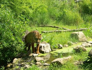 One of the key mammals of the Tropical Rainforest Heritage Parks is the Sumatran tiger Panthera tigris sumatrae. (Source: Wikimedia Commons)
 Sumatra has a high level of endemism, which is well represented in the nominated sites. It is evidence of the land bridge/barrier between the Sumatran biota and that of mainland Asia due to changes in sea level. Some of the animal distributions may also be evidence of the effect of the Mount Toba tuff eruptions 75,000 years ago. The Sumatran orangutan for example, is not found south of Lake Toba nor the Asian tapir Tapirus indicus (EN) north of it. The altitudinal range and connections between the diverse habitats in these areas, in particular in GLNP and KSNP, must have facilitated the on-going ecological and biological evolution. Key mammals of the Parks are:
- Sumatran tiger Panthera tigris sumatrae (CR);
- Sumatran rhino Dicerhinos sumatrensis (CR);
- orangutan;
- Sumatran elephant Elephas maximus sumatranus (EN); and,
- Malayan sun-bear Helarctos malayanus; and,
the endemics:
- Sumatran grizzled langur Presbytis thomasi;
- Hoogerwerf's rat Rattus hoogerwerfi (VU); and;
- Maxomys hylomoides.
Rare birds noted in the nomination are:
- Sumatran ground cuckoo Carpococcyx viridis (CR);
- Rueck's blue flycatcher Cyornis ruckii (CR);
- Storm's stork Ciconia stormi (EN); and,
- white-winged duck Cairina scutulata (EN).
Gunung Leuser National Park is a part of one of 18 Indonesian regions classified by the WWF among the 200 global ecoregions of importance for conservation of the world's biodiversity. It has a cross-section of north Sumatran wildlife: 174 mammals, 3 being endemic and 21 listed as threatened in 2000 (3 CR 1 EN and 9 VU). Little is known about the smaller mammals. The birds are not known in depth but 380 species are listed, 13 being endemic and 52 threatened (1 CR, 1 EN and 6 VU). Important mammal species in GLNP are:
- the orangutan, its flagship symbol;
- Panthera tigris sumatrae (CR);
- Sumatran rhino Dicerhinos sumatrensis (CR);
- otter civet Cynogale bennettii (EN);
- clouded Asian wild dog Cuon alpinus (VU);
- Eurasian otter lutra lutra (VU);
- leopard Neofelis nebulosa (VU);
- Indian porcupine Hystrix brachyura (VU); and,
- pigtailed monkey Macaca nemestriana.
Important bird species are:
- Rueck's blue flycatcher Cyornis ruckii (CR);
- white-winged duck Cairina scutulata (EN);
- Spizaetus nanus (VU);
- Lophura hoogerwerfi (VU);
- L. inornata (VU);
- Treron capellei (VU);
- Pitta schneideri (VU); and,
- Cochoa beccari (VU).
57 species of the herpetofauna are also recorded.
For Kerinci Sablat National Park, 85 mammal species are recorded, 5 endemic and 23 listed threatened (4 CR, 3 EN and 6 VU). 370 species of birds are listed, 13 being endemic and 58 threatened (1 CR, 1 EN and 7 VU). Important mammal species are:
- dwarf gymnure Holomys parvus (CR);
- Sumatran hare Nesolagus netscheri (CR);
- Panthera tigris sumatrae (CR);
- Sumatran rhino Dicerorhinos sumatrensis (CR);
- Beccari's shrew Crocidura beccari (EN);
- Sumatran elephant Elephas maximus sumatranus (EN);
- Asian tapir;
- Asian wild dog Cuon alpinus (VU);
- clouded leopard Neofelis nebulosa (VU); and,
- Sumatran goral Naemorhedus sumatrensis.
Important bird species are:
- Sumatran ground cuckoo Carpococcyx viridis (CR);
- white-winged duck Cairina scutulata (EN);
- Lophura inornata (VU);
- Heliopais personata (VU);
- Treron capellei (VU);
- Alcedo euryzona (VU);
- Pitta schneideri (VU);
- P. venusta (VU); and,
- Cochoa beccari (VU).
It has also nine species of hornbill. Lake Gunung Tujuh has an interesting fauna of amphibians and insects.
In Bukit Barisan Selatan National Park, 98 mammals are recorded, with 1 endemic and 25 threatened (4 CR, 6 EN and 6 VU). 379 species of birds are listed, 7 being endemic and 58 threatened (2 CR, 2 EN and 5 VU). 59 reptile and amphibian species are recorded (3 EN and 1VU). In BBSNP important mammal species are:
- Panthera tigris sumatrae (CR);
- Sumatran rhino Dicerhinos sumatrensis (CR);
- Sumatran hare Nesolagus netscheri (CR);
- Sumatran elephant Elephas maximus sumatranus (EN);
- otter civet Cynogale bennettii (EN);
- Asian tapir,;
- smoothcoated otter Lutrogale perspicillata (VU);
- flatheaded cat Prionailurus planiceps (VU); and,
- Chinese porcupine Hystrix brachyura (VU).
The herpetofauna includes:
- leatherback turtle Dermochelys coriaceae (CR);
- green turtle Chelonia mydas (EN);
- spiny terrapin Heosemys spinosa (EN);
- Bornean river turtle Orlitia borneensis (EN); and,
- Malayan flatshell turtle Notochelys platynota (VU).
Important bird species are:
- Sumatran ground cuckoo Carpococcyx viridis (CR);
- Rueck's blue flycatcher Cyornis ruckii (CR);
- Storm's stork Ciconia stormi (EN);
- white-winged duck Cairina scutulata (EN);
- Alcedo euryzona (VU);
- Spizaetus nanus (VU);
- Mycteria cinerea (VU);
- Treron capellei (VU); and,
- Pitta venusta (VU).
Cultural Heritage
Ten sites with tools of stone and wood 10,000 years old have recently been discovered in Tiangko Panjang cave in KSNP, proving long settlement of the island. Sumatra has a great variety of ancient and sophisticated ethnic tribal groups and sub-groups among which the Minangkaban have a very finely developed artistic tradition. There are at least seven different tribes in and around GLNP, with their own languages and cultures from the Aceh and Gayo muslim farmers in the north, Batak highland farmers and Pakpak hunters and swidden hill farmers to the Alas, Singhil and Melayu rice farmers and fishermen of the lowlands mixed with Javanese once imported by the Dutch. The Minangkaban are a leading tribe in the north of KSNP with the Kerinci in the middle, the Ipuh on the west coast and the Rejangin in the south. Most farm various crops, living in longhouses with traditional clothing and dances but are being challenged by outside influences. In BBSNP the native Lampung form only 15%, the rest being immigrants from further north or from Java, Sunda, Bali, and Madura.
Local Human Population
In GLNP a population of over 867,000 lived in the 31 buffer sub-districts in 1990, itself an increase of 50% on the 1970 figure. Six small enclaves have been discovered whose people have been persuaded not to harm the forest. Within the nine buffer zones of KSNP 3,647,241 lived in 1996, an increase of a fifth on the population ten years previously. And within the 20 buffer zone sub-districts and 4 enclaves of BBSNP 225,471 people lived in 2001. This fast expanding population is putting pressure on Park boundaries, forests and resources which makes effective protection of these all the more urgent.
Visitors and Visitor Facilities
All three nominated parks have outstanding tourism potential. However, a variety of factors impede the its development: inadequate strategic planning, totally inadequate and derelict infrastructure in parks and poor roads in some places outside parks, uncertainty in the protection of natural resources, illegal activities degrading the Parks and security problems in the Aceh province. Relatively little tourism has therefore developed except for visitors to the orangutan rehabilitation stations in GLNP where there is also some jungle trekking and river rafting. Visitation has fluctuated with the political situation but GLNP has averaged 15,490 visitors a year during the past five years, over half being foreigners. Facilities include accommodation, a visitor center, guides, a trail, observation tower, campground and shelter. KSNP averaged 3,799 visitors a year between 1993 and 2001. It has accommodation, interpretation boards and a trail. From 1995 to 2001 BBSNP had an average of 331 visitors a year. It has four cottages, a guest house, a dock with 2 speedboats, an information center, a campground, 2 shelters and 13 km of trails. This low level of tourism has not yet degraded the land, but all the Parks plan to develop ecotourism in the future.
Scientific Research and Facilities
Nearly all the references quoted in the bibliography are from the last twenty years, most from the last decade. However, from 1972 and 1973, work has been done in the two private orangutan rehabilitation and research stations, now to be continued by Conservation International (CI). In GLNP during the 1980s and 1990s, several inventories were made with WWF-Indonesia of species, habitats and [[population]s] in certain areas, including of rhino, elephant and tiger. With cooperation between universities and the Park's research stations, 34 research projects were started between 1999, 12 by Indonesians, 22 by foreigners, and in 2000, 60 projects are said to be ongoing, three-quarters of them by Indonesian researchers. Funding has come from government, WWF-I, the EU and CI. In KSNP there have been 30 small recent projects with funding from FFI, WWF-I, and the Indonesian Biodiversity Foundation. Forest cover and loss have been analysed. In BBSNP 15 surveys have been ongoing into birds, monkeys, rhinos, tiger, elephant, green turtles, the herpetofauna, communities and fire prevention, funded by the EU, WWF, the World Conservation Society, the Indonesian Rhino Conservation Program and PT Sac Nusantara, a private nature tourism project.
Conservation Value
Despite vast destruction, Sumatra still contains some of the [[rich]est] and most varied of the world's remaining rainforests, comparable with those of Borneo and New Guinea. They retain their importance as critically important refugia for future [[evolution]ary] processes but they are under threat. In the three National Parks it has a series of forested [[mountain]s] of exceptional beauty, from lowlands to highlands, large enough to preserve the integrity of their ecosystems and water catchments, with a wide range of [[soil]s], hydrological conditions and habitats from marine to subalpine and a high diversity of flora and fauna representing much of Sumatra's natural heritage and threatened species.
Conservation Management
A main reason for the Parks' nomination as a cluster is to promote internal coordination and international cooperation. If World Heritage status is granted, workshops involving government, villagers, stakeholders and nongovernmental organizations (NGOs) will work towards these goals, but there is no coordinated management framework at present. Each of the parks is administered by a separate authority under the national Directorate General of Forest Production & Nature Conservation in the Ministry of Forestry and each park follows its own policies. The government's policy of decentralization to district level is not applied to protected areas because some extend over several districts and some districts see them as uneconomical and neglect their upkeep. There is unsettling confusion about this.
In 1990 the government required each Park to produce a 25-year Master Plan. These were completed in 1995. Adjusted for each park, they covered boundaries, zoning, species and habitat management, protection, coordination with local government, NGOs and villagers, sustainable uses and community participation, services and public awareness, nature tourism, training, facilities and infrastructure, research, monitoring and enlargement of the protected area. At present policies for protection cover the improvement of training, equipment and the regularity of ranger patrols, the coordination of different agencies and educating villagers especially in buffer zones to help fight natural disasters and to help to police illegal logging and poaching. Monitoring reports are expected every month, 3-months, 6 months and year on primary indicators of the Parks' health: forest loss through fire, logging and disease, presence of indicator species, numbers of visitors, research projects and publications, arrests and prosecutions and condition of staff and equipment.
Each Park has developed major programs to meet specific needs, often assisted and funded by national and international organizations. GLNP has five: a Less Developed Village Program to improve villagers' welfare and reduce their pressure on the Park with advice on farming and crafts; an Enclave Development Program to move people living in the Park and train them not to disturb it; a Conservation Development Program with WWF-Indonesia to provide alternatives to conflict between local communities and the Park; also educational exhibitions, training and >conservation courses and rallies; the Leuser Development Program with the EU to conserve 2.5 million hectares of rainforest in the Leuser ecosystem; CI's Indonesia's Orangutan Project to promote law enforcement and public awareness and CI's Critical Ecosystem Partnership Fund to provide district level coordination for effective forest stewardship.
KSNP has four programs: the Kerinci Sablat Integrated Conservation and Development Project (with the World Bank, GEF, FFI, WWF-I, the Indonesian Biodiversity Foundation, local NGOs and villagers) to secure biodiversity and halt fragmentation by improving the protection and management of the Park; a Village Conservation Agreement to legalize accession to the Park for 72 villages in return for their cooperation in protection, using local sanctions against violators; an Adat Village Forest Program to conserve rich buffer area forests through local village participation using traditional sanctions (adat); support for the inclusion of Sippurak Hook to absorb a rich privately owned primary lowland forest; 4 Governors and 9 District Heads have also signed a note of agreement to cooperate to protect the Park; also awareness campaigns among politicians, journalists and NGOs and an extension service to villagers, schools and youth clubs.
BBSNP has four programs: a Wildlife Conservation Society-Indonesia Program to research and conserve the Sumatran tiger and elephant populations; a WWF-Indonesia Program to improve the protection of the Sumatran rhino and elephant; the Indonesian Rhino Conservation Program; and PT Sac Nusantara; also conservation education for local people. All three use all the usual written methods of dissemination.
The EU sponsored Leuser Ecosystem of protected areas within which the GLNP is embedded is to be independently managed as a buffer area for the next 30 years. However, the Ecosystem, especially the Singkil Barat Wildlife Reserve, Langsa lowlands and foothills, and the Aceh Highlands and Tapaktuan lowlands, has essential (and for orangutan, critically important) habitat and migration routes for the four GLNP threatened flagship species, but they are all outside the nominated area. Similar protected buffer areas adjoin the other sites but are more vulnerable to encroachment. The nominated area of KSNP has many irregular borders which are difficult to defend and which exclude several adjacent areas used by flagship species. Pressures are not much less on BBSNP.
Management Constraints
The protection of these forests which are among the last and largest sources of commercially valuable tropical hardwoods in Asia is threatened by four major factors - encroachment for illegal logging, for agriculture and settlements, large animal poaching and roads, and two lesser threats - mining and natural disasters. Road construction is the major threat to all three Parks since, in the absence of effective law enforcement, it opens the way for logging which is the major cause of degradation, and the other main threats. Encroachment by fire is also serious. In 1997 1.5 million hectares of Sumatra were burnt, mostly due to fires deliberately set to clear land for other uses (Land-use). Other natural disasters such as landslides and erosion, flooding and silting of rivers, are aggravated by such clearance and other human disturbance such as mining and oil prospecting. However, in GLNP these have been limited by objections lodged with the Ministry of Forests; in KSNP there small gold mines which are less damaging than their access roads. Although countered by confiscation and arrests there is little political will to control the illegal activities of the combination of businessmen and powerful members of the police, the army, the government and parliament who profit greatly from them.
Logging seriously degraded GLNP between 1976 and 1988, which now suffers from smaller agricultural encroachments. A mixture of persuasion and legal action is used to control loggers. But in Aceh province a network of roads is proposed which will fragment the northern part of the National Park, especially the Ladia Galaska road. KSNP is very vulnerable because of its irregular borders; its flat lands have suffered much incursion by farming, especially for cinnamon gardens and it lost 10% of its forests between 1998 and 2000. The narrow link between the east and west parts of the Park needs reinforcement. Poaching, especially of rhino and tiger, also of elephant, sambar, wild pig and birds is serious. BBSNP which also has irregular borders has been invaded for coffee and rice cultivation and, legally, for logging. Three roads cutting across the Park are planned which, as with logging access roads, will inevitably open it up to other uses. Between 1998 and 2001, 32 tigers were taken - 10 tigers in 2001 alone. It is in need of far better protection and management. The surrounding people regard the forests as theirs to use by right and their poverty leads to lack of cooperation and conflict.
Management plans exist but are not well known by the staff: better training is necessary; also better pay to attract more rangers, better villager relations and better departmental cooperation at government level. The lack of staff, threats to life and corruption are major problems. Law enforcement needs to be more effective and better supported with vehicles and equipment. Management's successes in limiting logging, poaching and new roads in the Parks have alienated local governments. Several programs of cooperation with local people have been tried with varying success. In some cases, local communities and local government are seen by managers as a serious threat to the parks: in others they play a supporting role.
Staff
GLNP: 4 Heads of sub-areas with 237 staff: 7 administrative with 124 support staff, 82 rangers and 24 foresters. KSNP: 4 Heads of sub-areas with 162 staff: 57 administrative staff, 105 rangers plus 5 provincial officials and 176 in regional offices. BBSNP: 3 Heads of sub-areas with 127 staff: 6 administrative with 42 support staff, 61 rangers, 8 foresters and 10 labourers. Training is given in park management, administration and finance, tourism and ecotourism, inventorying species, forest protection and fire fighting, communication and guiding, wardening and law enforcement.
Budget
GLNP: In 2001, based on the figures for 2000, this was estimated at US$190,000: 50% from the national budget, 43% from the Reforestation and Forest Development Funds and 7% from the Management Strengthening Fund. KSNP: From 1996-2002 funding of US$46,000,000 came from the Kerinci Sablat Integrated Conservation & Development Project,: a US$19 million loan from the World Bank, US$15 million from the GEF and US$12.5million from the government. New sources are now needed. BBSNP: In 2001 this was approximately US$6,976,000: 73.5% from the national budget directly and through provincial and district subventions, 26.5% from the Reforestation Fund.
Tropical Rainforest Heritage of Sumatra
- Gunung Leuser National Park (GLNP) II (National Park)
- Kerinci Sablat National Park (KSNP) II (National Park)
- Bukit Barisan Selatan National Park (BBSNP) II (National Park)
- Natural World Heritage serial site Natural criteria ii, iii, iv.
Further reading
- Tropical Rainforest Herigage of Sumatra, World Heritage Scanned Nomination (2004) /files/200201_200300/200254/tropical-rainforest-heritage-of-sumatra---world-heritage-scanned-nomination.pdf
- De Wilde, W. & Duyfjes, B. (1996). Vegetation, Floristics and Plant Biogeography in Gunung Leuser National Park. In van Schaik, C. & Supriatna, J. (2000). Leuser: A Sumatran Sanctuary, Yayasan Bina Sains Hayati Indonesia. ISBN: 9799509904.
- Directorate General of Forest Production & Nature Conservation (2003). Submission for Nomination of Tropical Rainforest Heritage of Sumatra to be Included in the World Heritage List. Ministry of Forestry, Jakarta. A bibliography of 42 references.
- Flora and Fauna International, (2003). The Ecological and Subsequent Social-Economic Impacts of Ladia Galaska, Technical Memorandum, Sumatran Elephant Conservation Program, FFI, Cambridge, U.K.
- Hilton-Taylor, C. (compiler) (2000). 2002 IUCN Red List of Threatened Species. IUCN, Cambridge, U.K. ISBN: 2831705657.
- Marshall, A., Jones, J. & Wrangham R. (2000). The Plight of the Apes: a Global Survey of Ape Populations. Briefing paper. Department of Anthropology, Harvard University.
- Thornton, I. (1997). Krakatau: The Destruction and Reassembly of an Island Ecosystem, Harvard University Press.
- van Schaik, C., Monk, K. & Robertson, J. (2000). Dramatic decline in orang-utan numbers in the Leuser Ecosystem, Northern Sumatra. Oryx ,Vol. 35 (1):249-258.
- Whitten, T., Damanik, S., Jazanul A. & Nazzaruddin H. (2000), The Ecology of Sumatra, The Ecology of Indonesia Series, Vol. I. Periplus Editions, Hong Kong. ISBN: 9625930744.
| Disclaimer: This article is taken wholly from, or contains information that was originally published by, the United Nations Environment Programme-World Conservation Monitoring Centre (UNEP-WCMC). Topic editors and authors for the Encyclopedia of Earth may have edited its content or added new information. The use of information from the United Nations Environment Programme-World Conservation Monitoring Centre (UNEP-WCMC) should not be construed as support for or endorsement by that organization for any new information added by EoE personnel, or for any editing of the original content. |