Tropical Dry Forests ecoregion
Contents
Tropical Dry Forests ecoregion (CEC)
| Topics: |
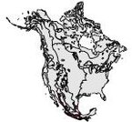 Map of the Tropical Dry Forest ecoregion.
 This ecological region stretches in a narrow and interrupted strip from Eastern Sonora and Southeastern Chihuahua to Chiapas; at Michoacán it includes the Balsas Basin. In the Tehuantepec isthmus, it splits to embrace the Central Chiapas Depression where it stretches along the Pacific to Central America and the northern extreme of South America. It also occupies the Northern Gulf Coastal Plain, the north of the Yucatán Peninsula and the southern tip of the Baja California Peninsula, covering almost 13 percent of Mexico.
Physical Setting
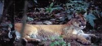 Cougars were once abundant in the Tropical Dry Forests. (Photo: Marcelo Aranda)
 This region occupies an altitudinal range between 200 and 1,000 meters (m) above sea level. Average annual temperatures vary between 20°C and 29°C. This tropical climate is characterized by intense episodes of rainfall, especially during summer. Overall, average annual [../155339/index.html precipitation is between 600 and 1,600 millimeters (mm). The dry season varies from 5 to 8 months. Soils are weakly developed, mainly from calcareous, metamorphic rocks and volcanic rocks. They have a variable depth from shallow to deep. Textures are also variable, from clayey to sandy, depending on the nature of the underlying bedrock. Steep relief occurs over 75 percent of the region.
The Pacific Coastal Plain and the Western Sierra Madre emerged in Paleozoic times. The Coastal Plain is a flat region dipping gently to the sea, interrupted by eroded hills surrounded by extended alluvial cones. Detritic material from Pleistocene and recent times cover the surface. A number of rivers traverse the plain as they drain toward the Pacific Ocean.
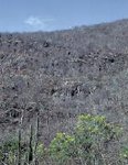 Hill near Tehuantepec, Oaxaca, that supports a tropical deciduous forest. (Photo: F. Takaki)
 The Balsas Basin emerged at the end of the Mesozoic period, and it is formed by mid-Cretaceous limestone; it is demarked by mountains of steep slopes. The Balsas Mezcala River and its tributaries dominate the surface waters of this basin. This ecological region only occupies the northwest corner of the Yucatán Peninsula, which is formed of Cretaceous sedimentary rocks, overlain by tertiary formations. The karst plains lack surficial flows.
Biological Setting
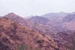 Hills and canyons of the Balsas River basin in Michoacan. (Photo: F. Takaki)
 A diverse flora is present, particularly in the tree and bush layers that are dominant in most of this area. Southern floristic elements are prominent, along with numerous endemic genera in the Mexican Pacific side. Low deciduous and sub-deciduous forests dominate. This implies a marked seasonal pattern and a physiognomic difference between dry and humid seasons. These forests are from 4 to 15 m tall and have three distinct strata. The low deciduous forests contain about 6,000 vascular plant species, of which 40 percent are endemic to Mexico. In its composition, legumes are predominant, and the floristic richness decreases from southeast to northwest. In the Balsas Basin, a large number of endemic species occurs, and it is the most significant region for the family of copales (papelillos), trees that are harvested for commercial and ritualistic uses. Other species of economic importance include parota, cuéramo, Mexican red cedar, palo de rosa, sabicú, jabin and henequen (false sisal).
Fauna include hare, squirrel, deer, lynx, ocelot and coati. Of the 253 vertebrates associated with Tropical Dry Forests, eight are endangered (IUCN Red List Criteria for Endangered). Thirteen species of vertebrates associated with the sub-deciduous forests are also close to extinction.
Human Activities
About 40 percent of the land area of this region has been converted to agriculture over the past few years. Total population is close to 13 million people, of whom 8 percent are indigenous. Twenty-nine percent of this population works in the agricultural sector. A third of Mexico’s agricultural products are produced in this ecological region, including 10 percent of the cattle and 65 percent of the total sorghum. Other important crops include wheat, sesame, henequen, cane, sunflower and corn. The region also contributes 45 percent of the pork production, 31 percent of chicken production and 20 percent of Mexico’s eggs.
Economic planning and development within the region has been haphazard. A few decades ago a development program was implemented to distribute large pieces of land within the Balsas Watershed and Apatzingán-Tepalcatepec. The objective was to promote production of basic grains. However, because of low returns, a switch to other crops took place. At the beginning, cotton was introduced. This crop soon caused considerable damage because of the abuse in associated agrochemicals which adversely affected flora and fauna. Cotton was abandoned when its international price dropped and was replaced by commercially valuable cash crops such as melon and mangoes. However, cultivation of these crops continues under the same intensive use of chemicals.
In the southeast, the Yucatán’s northern forests have been under human influence since the Prehispanic epoch. Slash-and-burn systems prevail in corn cultivation. In this century, sugar cane cultivation first, and henequen later, promoted a huge transformation of land use. During the mid-1970s, the failure of the henequen crop provoked abandonment of large areas that now are in different stages of afforestation. Backyard gardening and small-scale vegetable cultivation complement the low yields of corn production. Almost all production is intended for self-consumption. The city of Mérida and the port of Yucalpetén have become centers of economic activity and thus have attracted laborers from the entire Yucatán Peninsula.
| Disclaimer: This article is taken wholly from, or contains information that was originally published by, the Commission for Environmental Cooperation. Topic editors and authors for the Encyclopedia of Earth may have edited its content or added new information. The use of information from the Commission for Environmental Cooperation should not be construed as support for or endorsement by that organization for any new information added by EoE personnel, or for any editing of the original content. |