Tromelin Island
| Topics: |
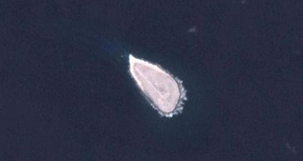
Tromelin Island is in the Indian Ocean east of Madagascar.
|
|

it is part of the French Southern and Antarctic Lands. It is also considered part of the Îles Éparses (Scattered Islands or Scattered Islands in the Indian Ocean -Îles éparses de l'océan indien) which include Bassas da India, Europa Island, Glorioso Islands, Juan de Nova Island, and Tromelin Island.
First explored by the French in 1776, the island came under the jurisdiction of Reunion in 1814.
At present, it serves as a sea turtle sanctuary and is the site of an important meteorological station.
Tromelin Island is climatologically important location for forecasting cyclones in the western Indian Ocean. It is uninhabited, except for visits by scientists.
Geographic Coodinates: 15 52 S, 54 25 E
Area: 1 sq km
Coastline: 3.7 km
Maritime claims:
territorial sea: 12 nm
exclusive economic zone: 200 nm
continental shelf of 200-m depth or to the depth of exploitation
Climate: tropical
Terrain: low, flat, sandy; likely volcanic seamount. The highest point is an unnamed location (7 m)
Natural Resources: fish, crayfish, guano, phosphates, and coconuts
Land Use: 100% grasses and scattered brush (2005)
Natural Hazard: subject to periodic cyclones
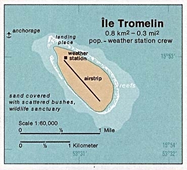
1976 Map. Source: CIA Map