Bassas da India
| Topics: |
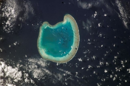
Source: NASA
Bassas da India (also Basse de Judie) is an atoll located in the southern Mozambique Channel, between Madagascar and Mozambique.
|
|

The atoll sits atop a long-extinct, submerged volcano and is surrounded by reefs.
Bassas da India atoll is an almost perfectly circular atoll with less than 1 km2 of permanently dry land area. The reef is 12-13 km in diameter, though it is almost entirely submerged at high tide, and therefore, does not support any vegetation. At low tide, the reef rim emerges 1.20 m, however, several rocks to the north are exposed at all times to a height of 2-3 m. Bassas da India's coral structure is still forming.
These islands are subject to the Agulhas Current and experience occasional cyclones. Water temperatures are usually above 30°C, and southeast trade winds dominate during the austral winter. Annual rainfall averages at about 600 millimeters (mm).
A French possession since 1897, it is part of the French Southern and Antarctic Lands. It is also considered part of the Îles Éparses (Scattered Islands or Scattered Islands in the Indian Ocean -Îles éparses de l'océan indien) which include Banc du Geyser, Bassas da India, Europa Island, Glorioso Islands (Glorieuse), Juan de Nova Island, and Tromelin Island.
Europa Island is about 100 kilometers (km) southeast of Bassas da India.
Ecologically, Bassas da India is part of the Ile Europa and Bassas da India xeric scrub ecoregion which covers the the atolls.
Bassas da India is claimed by Madagascar.
It is uninhabitable.
Geography
Geographic Coodinates: 21 30 S, 39 50 E
Area: 80 sq km (Note: land - 0.2 sq km; water - 79.8 sq km lagoon)
Coastline: 35.2 km
Maritime claims:
territorial sea: 12 nm
exclusive economic zone: 200 nm
Climate: tropical
Terrain: atoll, awash at high tide; shallow (15 m) lagoon. The highest point is an unnamed location (2.4 m).
Land Use: 100% rock, coral reef, and sand
Natural Hazard: subject to periodic cyclones. Bassas da India is a maritime hazard since it is under water for a period of three hours prior to and following the high tide and surrounded by reefs

Source: Eric Gaba/Wikipedia