Tonle Sap-Mekong peat swamp forests
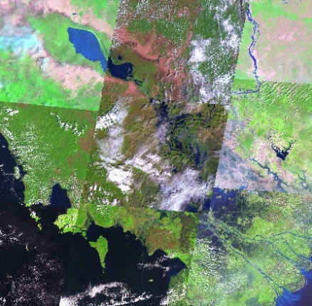
Satellite view of Tonle Sap (upper left) and the surrounding peat forest in Cambodia and southern Vietnam Photograph by USGS
The Tonle Sap-Mekong Peat Swamp Forests are only a small vestige of their former range and function.
More than 90 percent of this ecoregion has been converted to scrub or degraded forests. Intensive agriculture and the alteration of the hydrodynamics of the river systems in the region have altered the natural river fluctuations, adversely affecting the remaining native vegetation.
Contents
Location and General Description
The Tonle Sap-Mekong Peat Swamp Forests ecoregion extends over areas permanently inundated with shallow freshwater, although the region as mapped includes mosaics of swamp forest and herbaceous wetland interposed with upland areas of dry forest. However, care must be given in separating permanently flooded swamp forests of southeast Asia from seasonal swamp forests that characterize extensive areas of the Tonle Sap Basin and the floodplain of major Cambodian [[river]s]. Conditions of permanent flooding compared with flooding for 6-8 months produce differential selective factors and thus a distinctive floristic assemblage. Such conditions produce several notable characteristics of these floodplain habitats. Native palms, often a characteristic component of typical swamp forests, generally are absent from the Tonle Sap floodplain with the exception of the local occurrences of rattans in some gallery forests.
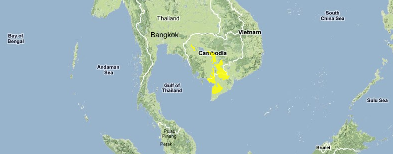 Source: WWF
Large areas of swamp forest are present in poorly drained landscapes of the Haut Chhlong and Blao regions of Vietnam where the water table reaches to the surface. These soils are saturated, with an upper horizon very rich in organic matter. Several formations of swamp forest have been described. The most widespread of these occurs at an elevation of 600-900 meters (m) and is characterized by a dominance of Livistona cochinchinensis (Arecaceae). This palm reaches up to 30 m in height. Many associated dicot canopy species have stilt roots or pneumatophores. These include species of Eugenia (Myrtaceae), Elaeocarpus (Elaeocarpaceae), and Calophyllum (Guttiferae).
Extensive areas of grass and sedge wetlands are also included in this ecoregion. Tall grasses such as Phragmites karka, Saccharum arundinaceum, and Coix gigantea generally dominate fertile alluvial clay sediments. Less fertile soils typically are characterized by a diverse assemblage of Poaceae and Cyperaceae and other herbaceous species.
Brackish and freshwater wetlands behind mangrove areas in Cambodia and the Mekong delta area of Vietnam typically are dominated by dense stands of Meleuca leucadendron called the paperbark [[swamp]s] or rear mangrove communities. Paperbark swamps once covered large areas of the Mekong delta region with acid sulfate soils subjected to seasonal inundation. Today the area of Melaleuca forests has been greatly diminished, although successful reforestation efforts have occurred. The largest remaining stands of Melaleuca forest occur on peat soils of the U Minh area of Minh Hai Province and on the acidic soils of the Plain of Reeds and Ha Tien plain in Vietnam.
Paperbark swamps are low in plant diversity but have a great significance in maintaining natural ecosystem function. These swamps reduce water flow in the wet season and thus minimize flooding, store fresh water, reduce soil acidification, promote biodiversity of many aquatic organisms, and provide a sustainable source of wood for construction and fuel.
Biodiversity Features
Mammal species of conservation significance include the possibly extinct wild water buffalo (Bubalus arnee), Eld's deer (Cervus eldii siamensis), Indochinese hog deer (Axis procinus annamiticus), and banteng (Bos javanicus). The reed beds are important sites for waterfowl, and the habitats provide feeding grounds for the eastern sarus crane (Grus antigone), the near-endemic giant ibis (Pseudibis gigantea), white-shouldered ibis (P. davisoni), glossy ibis (Plegadis falcinellus), black-headed ibis (Threskiornis melanocephalus), Asian openbill (Anastomus oscitans), and possibly the lesser adjutant (Leptoptilos javanicus) (Table 1).
Table 1. Endemic and Near-Endemic Bird Species.
|
Family |
Common Name |
Species |
|
Threskiornithidae |
Giant ibis |
Pseudibis gigantea |
An asterisk signifies that the species' range is limited to this ecoregion.
Current Status
This ecoregion is heavily altered, and very little (<10 percent) of the original habitat is left. Excessive forest exploitation has reduced many areas to scrub or secondary forest comprising non-indigenous species. Very little (<1 percent) of the ecoregion is protected, although the Tonle Sap Great Lake reserve, which extends into the ecoregion, is large (2,725 square kilometers (km2))) (Table 2).
Table 2. WCMC (1997) Protected Areas That Overlap with the Ecoregion.
|
Protected Area |
Area (km2) |
IUCN Category |
|
Hon Chong |
40 |
UA |
|
Vo Doi |
20 |
IV |
|
Total |
60 |
Types and Severity of Threats
Large areas of acid sulfate peat soils have been drained, cultivated, and subsequently abandoned, and these areas have become extensive reed beds. The mangroves and Melaleuca forests of the Mekong delta were severely affected by military activities in the Vietnamese wars; however, they have partially recovered through replanting programs. The vast floodplains of the Mekong River and Tonle Sap are extensively cultivated during the dry season, and local fishing communities have greatly altered the Tonle Sap swamp forests. The area of the Mekong delta that lies in southern Vietnam has also been severely affected by deforestation in water catchments in Laos, Thailand, and southern China. The river is now prone to flood more frequently and violently in the wet season but to reach very low levels in the dry season; this altered flow is creating increasing problems for local agriculture.
Justification of Ecoregion Delineation
We separated out the mangroves, freshwater swamp forests, and peat swamps in MacKinnon's subunit 05a and represented the peat swamps with theTonle Sap-Mekong Peat Swamp Forests.
| Disclaimer: This article is taken wholly from, or contains information that was originally published by, the World Wildlife Fund. Topic editors and authors for the Encyclopedia of Earth may have edited its content or added new information. The use of information from the World Wildlife Fund should not be construed as support for or endorsement by that organization for any new information added by EoE personnel, or for any editing of the original content. |