Thung Yai Naresuan Wildlife Sanctuary, Thailand
Contents
- 1 Geographic Location
- 2 Date and History of Establishment
- 3 Area
- 4 Land Tenure
- 5 Altitude
- 6 Physical Features
- 7 Climate
- 8 Vegetation
- 9 Fauna
- 10 Cultural Heritage
- 11 Local Human Population
- 12 Visitors and Visitor Facilities
- 13 Scientific Research and Facilities
- 14 Conservation Value
- 15 Conservation Management
- 16 IUCN Management Category
- 17 Further Reading
Geographic Location
Thung Yai Naresuan Wildlife Sanctuary (14°55'-15°45'N, 98°28'-99°05'E) is a World Heritage Site situated in the Kanchanaburi and Tak provinces of Thailand alongside the western international border with Burma and located at the southern end of the Dawna Range.
Date and History of Establishment
- Established: 24 April 1974.
- Inscribed with Huai Kha Kaeng Wildlife Sanctuary on the World Heritage List in 1991.
Area
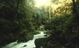 The Lum Klong Ngoo, Thung Yai Sanctuary. (Source: Western Forest Conservation Club)
 At 320,000 hectares (ha), it is the largest conservation area in Thailand. With the inclusion of recent extensions and combined with the adjacent Huai Kha Khaeng Wildlife Sanctuary (257,464 ha), it is the largest conservation area in Mainland Southeast Asia, covering a total 622,200 ha. In addition, Thung Yai adjoins Umphang Wildlife Sanctuary to the north (251,600 ha), which has been demarcated but not yet gazetted, and Bung Kroeng Kawia Non-Hunting Area (51,200 ha) and Khao Laem proposed National Park (122,300 ha) to the south. Both Thung Yai Naresuan and Huai Kha Khaeng wildlife sanctuaries constitute a major component of the protected areas cluster in western Thailand, comprising Sri Nakarin National Park (153,200 ha), Chaloem Rattankosin National Park (5,900 ha), Erawan National Park (55,000 ha), Sai Yok National Park (50,000 ha) and Salak Phra Wildlife Sanctuary (85,855 ha). It is proposed to increase the size of the sanctuary by 47,700 ha with the incorporation of the Nam Choan Forest Reserve. Recent additions have increased the total area protected to 1,208,300 ha.
Land Tenure
Government.
Altitude
Ranges from 250 meters (m) to the peak of Khao Thai Par at 1,811 m in the southwest quarter of the sanctuary. There are several peaks over 1,500 m and many over 1,100 m distributed throughout the sanctuary.
Physical Features
The topography is generally mountainous with a network of many permanent rivers and streams dividing the area into valleys and lowland plains. The sanctuary's distinguishing feature is a large central grassland plain, from which it takes the name of Thung Yai (meaning 'big field'). Within the catchment area are four important rivers: the Mae Khlong, which flows into the Kwai Yai (of "Bridge over the River Kwai" notoriety) and feeds into the Sri Nakarind Dam; Kwae Noi, which feeds into Khao Laem Reservoir; and Mae Kasart and Mae Suriat which, respectively, flow into Mekathat and Huang Tharaw rivers in Myanma. Red-brown earths and red-yellow podzols are the predominant soils, the former derived from limestone and found in the level uplands and Mae Chan Valley, whilst the latter is found in the Huai Kha Khaeng Valley. A physical feature that is important for wildlife is the presence of mineral licks. These occur throughout the sanctuary as either wet or dry, and most appear to be located on, or around, granite intrusions in areas with red-yellow podzolic soil and may be associated with the massive faults or lineaments in the intensely folded geomorphology of this area. Small lakes, ponds and swampy areas occur, some being seasonal whilst others are perennial; these are important wildlife habitats. Limestone sink holes are found; most are only about 20 m in diameter and 10-12 m in diameter, but some are more than 2 kilometers (km) long, 250 m wide and drop as much as 30 m depth.
Climate
Conditions range from tropical to semi-tropical. The climate is monsoonal, with a dry season from November to April/May, and a hot wet season from May to October. Mean annual rainfall in the west is 2,000-2,400 mm, declining to 1,600-2,000 mm in the east. There is a strong orographic effect, and more than 80% of the rain is brought by the southwest monsoon. Mean minimum and maximum temperatures range from 15 degrees Celsius (°C) to 35°C during the hot season; 20°C to 33°C during the wet season and 10°C to 29°C during the cooler season. Minimum and maximum night and day temperatures fall in the range 7°C to 40°C.
Vegetation
The principal vegetation types, and their estimated cover is as follows: hill evergreen forest (54,900 ha); dry evergreen forest (112,900 ha); mixed deciduous forest (164,100 ha); dry dipterocarp forest (3,600 ha); savanna forest (9,900 ha); grassland (3,900 ha); and areas of swidden agriculture (15,400 ha). The highest ground is generally covered with hill evergreen forest, also known as tropical lower montane rain forest, but slopes above 600 m generally support dry evergreen forest (seasonal evergreen forest). This latter formation is tall, dense, stratified and always dominated by Dipterocarps, and may appear to be evergreen in wet areas such as the central uplands of the sanctuary. In some areas, particularly broad valleys, there is often a mosaic of vegetation types.
At lower altitudes mixed deciduous and bamboo forests predominate, with dry deciduous dipterocarp forest occurring in areas with poor or shallow soil. Mixed deciduous forest is the most predominant formation, probably dominated by Lagerstroemia calyculata associations, although pure stands of Xylia xylocarpa are found. Dry dipterocarp forest, also referred to as dry deciduous dipterocarp, is unique to mainland Southeast Asia. It is dominated by five xerophilous dipterocarps and is confined to the poorest and most porous soils where fire occurs. Savanna forest and grassland, both very similar formations, occur at every elevation, although the 'thung yai' covers 14,000 ha. Some 17 trees occur in the savanna forests, of which L. macrocarpa, Stereospermum nueranthum, Terminalia chebula and Dalbergia cultrata are amongst the most common. Trees within grassland are smaller, of generally the same genera, but not exceeding 5 m, and stunted either by fire or other edaphic constraints.
In particularly moist areas along rivers and streams, evergreen gallery forest is present. This is noticeably lusher than other formations, and harbours many more creepers, climbers and epiphytes, with emergents as high as 40 m. The gallery forest sustains a higher than usuallevel of biological diversity in comparison to the more widespread but drier habitats, especially during dry season fires. The most important wetlands are those along the upper Khwae Yai and is tributaries, the Mae Klong and Mae Chan, both deep, fast flowing rivers with steep banks, muddy bottoms and frequent rapids and rocky ravines.
Secondary forest on areas of former swidden agriculture are found in the Mae Chan Valley and central uplands towards the east. Swidden agriculture has been practiced in areas of the most fertile soils which indicates that some of the richest forest has been destroyed but also that there is a good chance of regeneration. Characteristic species are those that grow in the surrounding forest, including L. macrocarpa, Vitex peduncularis, Bauhinia acuminata and Albizia odoratissima.
Fauna
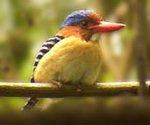 The Banded Kingfisher, Thung Yai Sanctuary. (Source: Western Forest Conservation Club)
 The fauna of both Thung Yai and Huai Kha Khaeng includes an unusual mix of species with primarily Sundaic, Indo-Chinese, Indo-Burmese and Sino-Himalayan affinities, many of whose ranges do not overlap. Most species are either characteristic of the Oriental/Indo-Malayan region or more specifically associated with the Indo-Chinese province of that region, but with a strong Sundaic element included. A small proportion is Palaearctic.
Thung Yai has not been comprehensively surveyed, but it is known to support a significant proportion of Thailand's fauna. It is big enough to support several of the larger and increasingly rare mammal species, such as tiger Panthera tigris (E), leopard P. pardus, clouded leopard Neofelis nebulosa (V), Elephas maximus (E), tapir Tapirus indicus (E), Sumatran rhinoceros Didermocerus sumatraensis (E), gaur Bos gaurus (V), mainland serow Capricornis sumatraensis (I) and hog deer Cervus porcinus. A herd of 50 gaur was seen in 1985, making it the largest herd recorded in Thailand. Neither banteng B. javanicus (V), nor wild water buffalo Bubalus arnee (E) has yet been reported from Thung Yai, although both occur in neighbouring Huai Kha Khaeng Wildlife Sanctuary. The Javan rhinoceros Rhinoceros sondaicus (E) is said to have existed in the area and a track was photographed in 1988.
Notable bird species include white-winged wood duck Cairina scutulata, Kalij pheasant Lophura leucomelana, Burmese peafowl Polyplectron bicalaratum and green peafowl Pavo muticus (V).
A detailed summary discussion of the fauna of the combined Thung Yai-Huai Kha Khaeng sanctuaries is given in ONEB (1990) and species lists have been compiled. This includes some 120 mammals, 400 birds, 96 reptiles, 43 amphibians and 113 freshwater fish as confirmed occurrences, with a number of species suspected as being present but not confirmed. Thirty-four internationally threatened species are also found within the confines of the two sanctuaries.
Cultural Heritage
It is certain that Thung Yai contains several sites of great archaeological interest, possibly dating back to the Pleistocene era when early hominids are thought to have migrated east and southwards through the area. Stone artifacts have been found which reinforce this supposition, but the area has yet to be properly investigated.
Local Human Population
Some 3,800 tribal people live within the sanctuary. There are still four Hmong villages, mainly in the north-east and east although 900 peoplewere moved out of the sanctuary in 1988. Some Karen have been established in the area for at least 50 years, whereas the Hmong are said to have moved in from further north 20-30 years ago. Both groups cultivate crops around their villages, but the impact of their activities on the forest has not been assessed. Since 1987, 2-3 Hmong villages have been moved each year to Phop Phra district in Tak province, about 80km north of the Thung Yai-Huai Kha Khaeng sanctuary complex. By 1991 all villages will have been closed. Sixteen Karen villages (1,826 people) are still resident, but there are plans to resettle them. Similarly, it is envisaged that Thai villages established in the proposed buffer zone around the Thung Yai-Huai Kha Khaeng sanctuary complex will also be resettled.
Visitors and Visitor Facilities
The sanctuary is not open to the general public, but permission may be given to researchers, naturalists and education groups for specific purposes. Some 400-500 visitors come each dry season. Permits can be obtained from the Wildlife Conservation Division in Bangkok, or from the Chief of the Sanctuary. Thung Yai is accessible by road (mostly unsurfaced) from Bangkok via Kanchanaburi. The journey takes 10-12 hours. A four-wheel drive road passes through the sanctuary from the headquarters to a mining concession on the international border.
Scientific Research and Facilities
Very little scientific research has been undertaken and there are no facilities. Approximately six times more research has been conducted in Huai Kha Khaeng than in Thung Yai.
Conservation Value
Watershed protection in both Thung Yai and Huai Kha Khaeng is conservatively estimated to be worth some US$ 13.8 million annually. Both Thung Yai and Huai Kha Khaeng are considered key sites for the conservation of lowland and montane bird species and Thung Yai contains the largest and least disturbed expanse of riverine forest in Thailand. The justification for the inscription of the Thung Yai-Huai Kha Khaeng sanctuary complex on the World Heritage List, argues that the site is biogeographically unique, capable of sustaining flora and fauna indefinitely, of exceptional natural beauty and scientific value, and includes very high biological diversity. Being located in a transition zone between the tropics and sub-tropics and, perhaps, because it was a Pleistocene refugium, a number of species of birds and mammals are found to be sympatric here. Few other areas of dry tropical forest in the region are as large, as well protected or as pristine. The complex also contains outstanding examples of the rock formations which distinguish the western edge of mainland South-East Asia from the more stable continental core, and is probably one of the best modern examples of the impact of the Pleistocene epoch on the distribution and dispersal of South-East Asian fauna. The impact of geological activity on an area of pristine dry tropical forest is exemplified better than elsewhere.
Conservation Management
A management plan has been prepared by a team from Kasetsart University, and this has been discussed and approved by the Royal Forest Department's Management Plan Committee. Four permanent and five temporary guard stations were established in the south between 1982-1986 and six more approved for the north in 1988. A further 9 are planned, bringing the total to 19, with a commitment to eventually reduce the area of sanctuary per guard station from 214 square kilometers (km2) to 64 km2. Remoteness and difficulty ofaccess are its main safeguards at present. There is at present no legally defined buffer zone although the need for one is recognised.
Management Constraints
Despite being the largest conservation area in Thailand, Thung Yai receives roughly the same allocation of manpower and money as sanctuaries half its size. Poaching is the most persistent problem and more resources are badly needed to effectively protect the area. Encroachment is increasing with the construction of the Sri Nakarin and Khao Laem dams to the south and EGAT's illegal road to the proposed Nam Choan Dam site.
The most serious threat was the proposed Nam Choan Dam project which was revived in 1986 but indefinitely postponed in 1988. There was fierce opposition to the project from wildlife conservationists for two main reasons. First, the dam's 75 km reservoir would have split the sanctuary into three smaller areas, which would greatly reduce the long-term survival prospects of the larger mammals. Secondly, the reservoir would have flooded lowland habitat below 380 m. Lowland forests are already rare in Thailand and are poorly represented in the protected areas system. Lowland riverine habitat is especially rare. Several threatened species occur almost exclusively in this kind of habitat, for example short-clawed otter, smooth-coated otter, green peafowl, lesser fish eagle, white-winged wood duck and red-headed vulture as well as many plant species. Valley bottom habitats, such as the Mae Chan Valley which would be flooded, are thought to provide optimal habitats for most of the large herbivores, for example tapir, elephant and wild cattle species. Although the Nam Choam dam project has been shelved there remains the possibility that it could be revived at some point in the future.
Staff
Thung Yai Naresuan has 6 officials, 13 rangers and about 150 guards. This is expected to increase during the 1991-1995 period of the management plan.
Budget
The allocation in 1986 was 828,000 (US$ 30,100) and 1.9 million baht in 1989. The current management plan envisages a budget of 13.5 million baht annually during the period 1991-1995. However, the allocation is unlikely to be granted in full.
IUCN Management Category
- IV (Habitat/Species Management Area)
- Natural World Heritage Site - Criteria ii, iii, iv
Further Reading
- Bhumpakan, N. and Kutintara, U. (1984). The wild fauna of Thung Yai Naresuan. Unpublished report. Kasetsart University, Bangkok.
- Brockelman, W.Y. (1987). 'Nature Conservation' in Arbhabhirama, Phantumvanit and Elkington. Thailand Natural Resources Profile. Thailand Development Research Institute, Bangkok. ISBN: 0195888871.
- Dobias, R.J., Tech, T., Wangwacharakul, V. and Sansawang, N. (1988). Beneficial use quantifications of the Huai Kha Khaeng and Thung Yai Naresuan Wildlife Sanctuary complex. Executive summary and main report. WWF Project 3757. (Unseen)
- Kasetsart University (1987). Assessment of national parks, wildlife sanctuaries and other preserves in Thailand. Final report. Faculty of Forestry, Kasetsart University, Royal Forest Department, Office of the National Environment Board, USAID. 130 pp.
- Kutintara, U. and Bhumpakkapun, N. (1989). Draft management plan for the Thung Yai Wildlife Sanctuary. Forest Biology Group, Faculty of Forestry, Kasetsart University, Bangkok. In Thai. (Unseen)
- Lekagul, B. (1983) Why the Nam Choan Dam must not be built. Conservation News, Association for Conservation of Wildlife, Bangkok. December: 3-5.
- Nakasathien, S., Bhumpakkapan, B. and Simcharoen, S. (1987). Forest and wildlife ecology in Thung Yai Naresuan and Huai Kha Khaeng Wildlife Sanctuaries. Wildlife Fund Thailand, Bangkok.
- ONEB (1990). Nomination of natural property to the World Heritage List: Thungyai-Huaikhakhaeng Wildlife Sanctuary. Office of the National Environment Board, Bangkok.
- Round, P.D. (1985). Status and conservation of resident birds in Thailand. Association for the Conservation of Wildlife. Bangkok. 143 pp.
- Round, P.D. (1988). Resident forest birds in Thailand: their status and conservation. ICBP Monograph No. 2. International Council for Bird Preservation, Cambridge, UK. 211 pp.
| Disclaimer: This article is taken wholly from, or contains information that was originally published by, the United Nations Environment Programme-World Conservation Monitoring Centre (UNEP-WCMC). Topic editors and authors for the Encyclopedia of Earth may have edited its content or added new information. The use of information from the United Nations Environment Programme-World Conservation Monitoring Centre (UNEP-WCMC) should not be construed as support for or endorsement by that organization for any new information added by EoE personnel, or for any editing of the original content. |